- May. 7, 2025
Arid Land Geography ›› 2021, Vol. 44 ›› Issue (3): 796-806.doi: 10.12118/j.issn.1000–6060.2021.03.22
• Climatology and Hydrology • Previous Articles Next Articles
WANG Shaona1( ),SONG Xiaoyu1(),LI Lanjun1,LI Huaiyou2,LI Yaolin2
Received:2020-04-26
Revised:2020-11-13
Online:2021-05-25
Published:2021-06-01
Contact:
Xiaoyu SONG
E-mail:1208766620@qq.com;songxy@xaut.edu.cn
WANG Shaona,SONG Xiaoyu,LI Lanjun,LI Huaiyou,LI Yaolin. Changing trend of green water and its driving factors in the gully region of the Loess Plateau[J].Arid Land Geography, 2021, 44(3): 796-806.
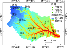
Fig. 1
Geographical location of Yanwachuan Basin and the distributions of meteorological, precipitation and hydrological stations"

Tab. 1
Basic hydrological and climatic characteristics of the Yanwachuan Basin"
| 年份 | 降雨/mm | 潜在蒸散发/mm | 气温/℃ | 干旱指数 |
|---|---|---|---|---|
| 1981—1989 | 541.2 | 1735.0 | 8.4 | 3.21 |
| 1990—1999 | 474.6 | 1818.8 | 9.1 | 3.83 |
| 2000—2009 | 540.0 | 1773.5 | 10.0 | 3.28 |
| 2010—2016 | 564.1 | 1762.2 | 10.2 | 3.12 |

Fig. 2
Interannual variation of annual rainfall, potential evapotranspiration and temperature in the Yanwachuan Basin"
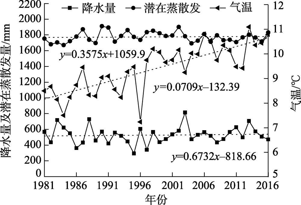

Fig. 3
Cumulative interannual anomaly values of rainfall, potential evapotranspiration and temperature in the Yanwachuan Basin"
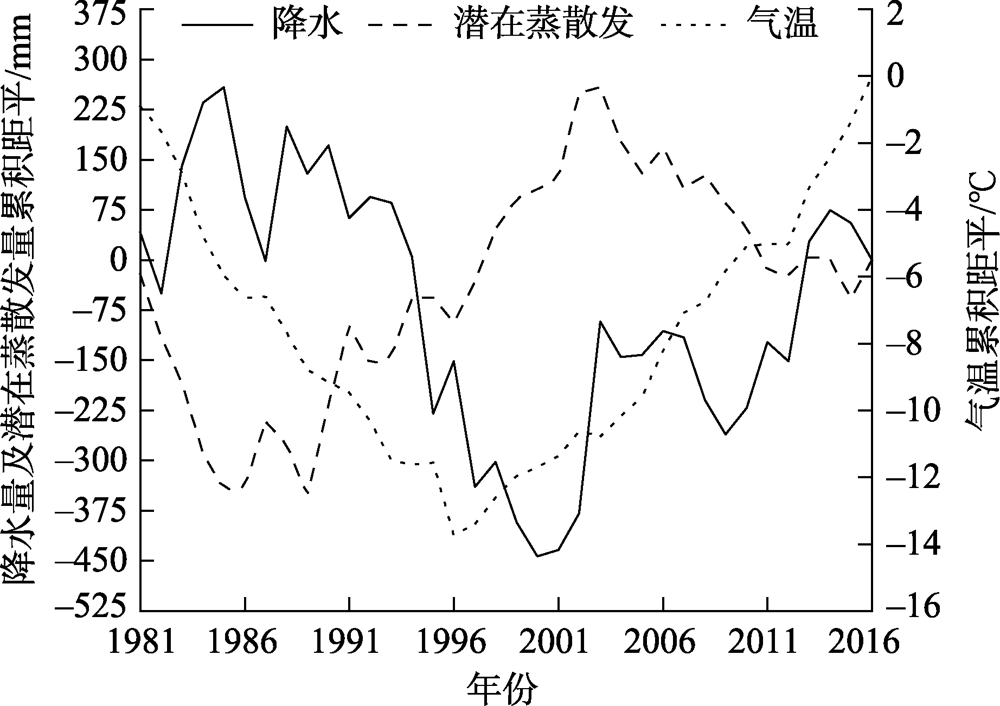

Fig. 4
Distribution of land use and area proportion of Yanwachuan Basin in different periods"
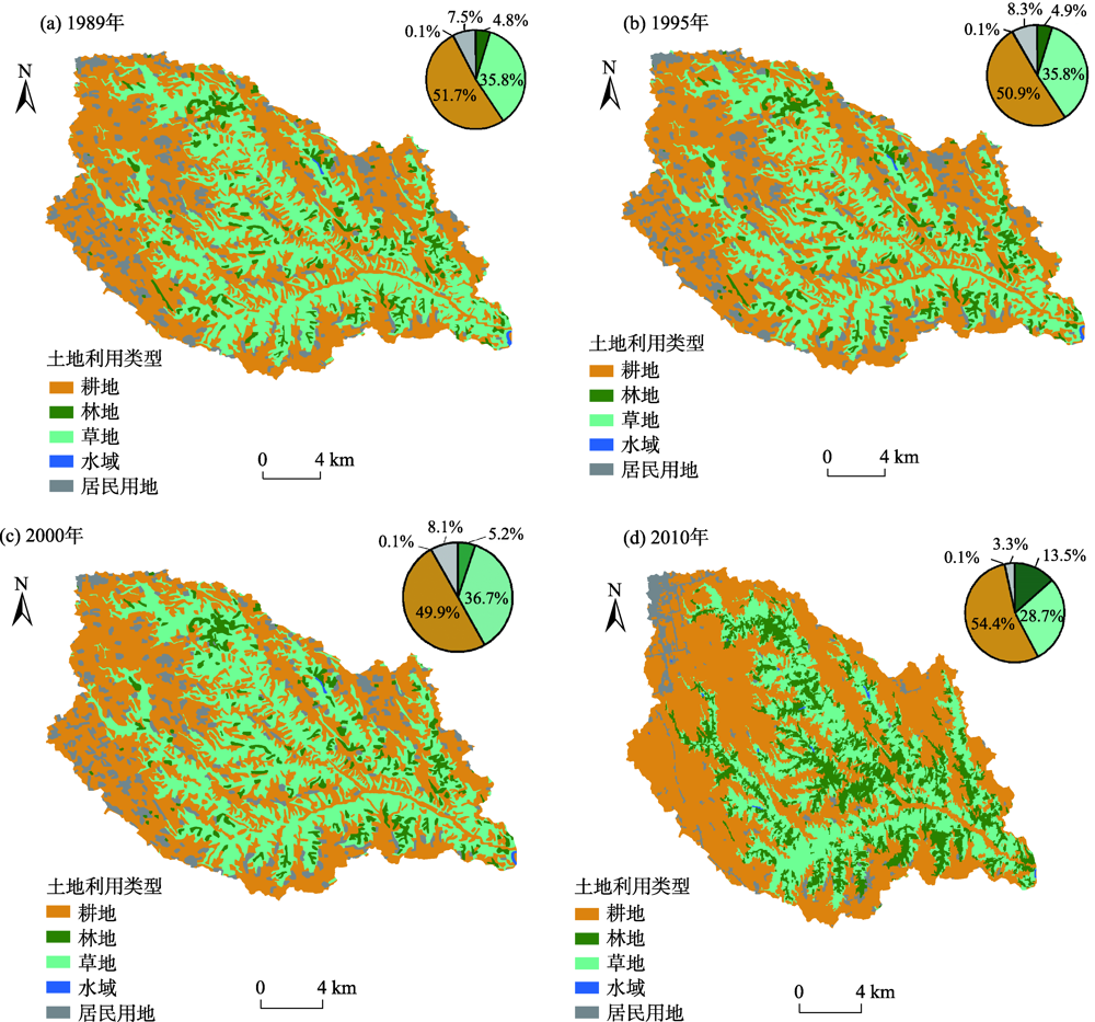

Fig. 5
Proportion of land use area change in the Yanwachuan Basin in different periods"
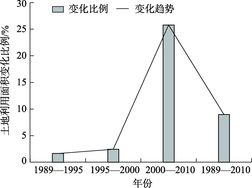
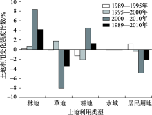
Fig. 6
Intensity index of land use change in the Yanwachuan Basin in different periods"
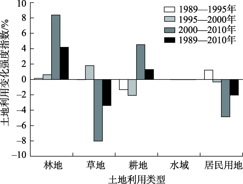
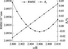
Fig. 7
Variations of Re and RMSE with ω"

Tab. 2
Statistics of the annual green water of Fu Baopu model"
 | 相对误差(  | 均方根误差(RMSE)/mm | ||
|---|---|---|---|---|
| 变化范围/% | 均值/% | |||
| 率定期(1981—2007年) | 2.806 | -5.22~4.30 | 0.02 | 0.0209 |
| 验证期(2008—2016年) | 2.806 | -2.83~1.17 | -0.92 | 1.0142 |
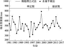
Fig. 8
Simulation results of actual annual green water during the calibration and verification period"


Fig. 9
Variation trend of green water in the Yanwachuan Basin from 1981 to 2016"

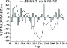
Fig. 10
Aomaly of annual green water in the Yanwachuan Basin from 1981 to 2016"
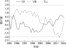
Fig. 11
Results of M-K test for annual green water in Yanwachuan Basin"


Fig. 12
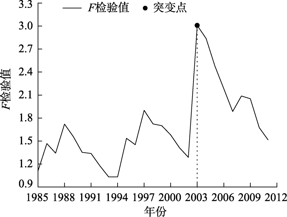
Sliding F test of annual average green water in the Yanwachuan Basin"
Tab. 3
Elasticity coefficient of green water to climate and parameter ω in Yanwachuan Basin"
| 年份 |  |    | |   |    |  |
|---|---|---|---|---|---|---|
| 1981—2002 | 509.6 | 1785.6 | 2.704 | 0.93 | 0.08 | 0.25 |
| 2003—2016 | 553.9 | 1756.4 | 3.004 | 0.94 | 0.07 | 0.15 |
| 1981—2016 | 526.8 | 1774.3 | 2.806 | 0.93 | 0.07 | 0.18 |
| 突变点前后变化 | 44.3 | 29.2 | 0.300 | - | - | - |
Tab. 4
Attribution of green water changes during the two periods"
     |  | | | 对绿水变化的贡献率/% | ||
|---|---|---|---|---|---|---|
| | | ||||
| 52.07 | 39.38 | -0.63 | 13.32 | 75.63 | -1.21 | 25.58 |
| [1] |
Falkenmark M. Meting water requirements of an expanding world population[J]. Philosophical Transactions of the Royal Society B Biological Sciences, 1997,352:929-936.
doi: 10.1098/rstb.1997.0072 |
| [2] | Rockström J. Green water security for the food makers of tomorrow: Windows of opportunity in drought-prone savannahs[J]. Water Science & Technology: A Journal of the International Association on Water Pollution Research, 2001,43(4):71. |
| [3] | 程国栋, 赵文智. 绿水及其研究进展[J]. 地球科学进展, 2006,21(3):221-227. |
| [ Cheng Guodong, Zhao Wenzhi. Green water and its research progresses[J]. Advances in Earth Science, 2006,21(3):221-227. ] | |
| [4] |
Postel S, Daily G, Ehrlich P. Human appropriation of renewable fresh water[J]. Science, 1996,271(5250):785-788.
doi: 10.1126/science.271.5250.785 |
| [5] | 李蓝君. 南小河沟流域绿水的水文过程及其与植被类型的耦合关系[D]. 西安: 西安理工大学, 2018. |
| [ Li Lanjun. Hydrological process of green water in the Nanxiaohegou Basin and its coupling relationship with vegetation types[D]. Xi’an: Xi’an University of Technology, 2018. ] | |
| [6] | 韩其飞, 陆研, 李超凡, 等. 气候变化对中亚草地生态系统碳循环的影响研究[J]. 干旱区地理, 2018,41(6):1351-1357. |
| [ Han Qifei, Lu Yan, Li Chaofan, et al. Impact of climate change on grassland carbon cycling in Central Asia[J]. Arid Land Geography, 2018,41(6):1351-1357. ] | |
| [7] | 刘濛濛, 隆永兰. 巴音布鲁克近58 a气候变化特征分析[J]. 干旱区地理, 2019,42(4):715-723. |
| [ Liu Mengmeng, Long Yonglan. Climatic variation characteristics in Bayinbuluke during the past 58 years[J]. Arid Land Geography, 2019,42(4):715-723. ] | |
| [8] | 岳辉, 刘英. 近15 a陕西省植被时空变化与影响因素分析[J]. 干旱区地理, 2019,42(2):314-323. |
| [ Yue Hui, Liu Ying. Vegetation spatiotemporal variation and its driving factors of Shaanxi Province in recent 15 years[J]. Arid Land Geography, 2019,42(2):314-323. ] | |
| [9] | 靳含, 杨爱民, 夏鑫鑫, 等. 基于CA-Markov模型的多时间跨度土地利用变化模拟[J]. 干旱区地理, 2019,42(6):1415-1426. |
| [ Jin Han, Yang Aiming, Xia Xinxin, et al. Simulation of land use change at different time spans based on CA-Markov model[J]. Arid Land Geography, 2019,42(6):1415-1426. ] | |
| [10] |
Li L, Song X, Xia L, et al. Modelling the effects of climate change on transpiration and evaporation in natural and constructed grasslands in the semi-arid Loess Plateau, China[J]. Agriculture Ecosystems & Environment, 2020,302:107077, doi: 10.1016/j.agee.2020.107077.
doi: 10.1016/j.agee.2020.107077 |
| [11] | 李蓝君, 宋孝玉, 夏露, 等. 黄土高原沟壑区典型造林树种蒸散发对气候变化的响应[J]. 农业工程学报, 2018,34(20):148-159. |
| [ Li Lanjun, Song Xioayu, Xia Lu, et al. Response of evaporation and transpiration of typical afforestation tree species to climate changes in gully region of Loess Plateau[J]. Transactions of the Chinese Society of Agricultural Engineering, 2018,34(20):148-159. ] | |
| [12] | 赵安周, 朱秀芳, 潘耀忠, 等. 典型年份渭河流域蓝水绿水时空差异分析[J]. 中国农业气象, 2016,37(2):149-157. |
| [ Zhao Anzhou, Zhu Xiufang, Pan Yaozhong, et al. Spatiotemporal variation of blue-green water under typical reference years in the Weihe River Basin[J]. Chinese Journal of Agrometeorology, 2016,37(2):149-157. ] | |
| [13] | 甄婷婷, 徐宗学, 程磊, 等. 蓝水绿水资源量估算方法及时空分布规律研究——以卢氏流域为例[J]. 资源科学, 2010,32(6):1177-1183. |
| [ Zhen Tingting, Xu Zongxue, Cheng Lei, et al. Spatiotemporal distributions of blue and green water resources: A case study on the Lushi Watershed[J]. Resources Science, 2010,32(6):1177-1183. ] | |
| [14] | 吕乐婷, 王晓蕊, 孙才志, 等. 基于SWAT模型的细河流域蓝水绿水资源量时空分布研究[J]. 长江流域资源与环境, 2019,28(1):39-47. |
| [ Lü Leting, Wang Xiaorui, Sun Caizhi, et al. Study on the spatiotemporal variations of blue and green water resources in Xi River Basin using the SWAT model[J]. Resources and Environment in the Yangtze Basin, 2019,28(1):39-47. ] | |
| [15] |
Gerten D, Hoff H, Bondeau A, et al. Contemporary green water flows: Simulations with a dynamic global vegetation and water balance model[J]. Physics and Chemistry of the Earth Parts A/B/C, 2005,30(6-7):334-338.
doi: 10.1016/j.pce.2005.06.002 |
| [16] | Zang C, Liu J, Jiang L, et al. Impacts of human activities and climate variability on green and blue water flows in the Heihe River Basin in northwest China[J]. Hydrology and Earth System Sciences Discussions, 2013,10(7):9477-9504. |
| [17] | 傅抱璞. 论陆面蒸发的计算[J]. 大气科学, 1981,5(1):23-31. |
| [ Fu Baopu. On the calculation of the evaporation from land surface[J]. Chinese Journal of Atmospheric Sciences, 1981,5(1):23-31. ] | |
| [18] | Budyko M I. Climate and life[M]. Pittsburgh: Academic Press, 1974: 508. |
| [19] | Yang D, Sun F, Liu Z, et al. Interpreting the complementary relationship in non-humid environments based on the Budyko and Penman hypotheses[J]. Geophysical Research Letters, 2006, 33(18): GL027657, doi: 10.1029/2006GL027657. |
| [20] | 闫浩芳, 史海滨, 薛铸, 等. 内蒙古河套灌区ET0不同计算方法的对比研究[J]. 农业工程学报, 2008,24(4):103-106. |
| [ Yan Haofang, Shi Haibin, Xue Zhu, et al. Comparison of estimating ET0 with different methods in Hetao Irrigation District in Inner Mongolia[J]. Society of Agricultural Engineering, 2008,24(4):103-106. ] | |
| [21] | 黄俊雄, 韩丽, 许志兰, 等. 基于Budyko理论的北京地区实际蒸散发估算及特征研究[J]. 水资源与水工程学报, 2020,31(3):1-7. |
| [ Huang Junxiong, Han Li, Xu Zhilan, et al. Estimation and variation of actual evapotranspiration of Beijing region based on Budyko theory[J]. Journal of Water Resources and Water Engineering, 2020,31(3):1-7. ] | |
| [22] | Kendall M G. Rank correlation methods[M]. London: Charles Griffin, 1975: 202. |
| [23] | 韩飞飞, 闫俊杰, 郭斌, 等. 阿勒泰地区植被覆盖度及ET对气温变化的响应[J]. 干旱区地理, 2019,42(6):1436-1444. |
| [ Han Feifei, Yan Junjie, Guo Bin, et al. Response of vegetation cover and ET to temperature variation in Altay Prefecture[J]. Arid Land Geography, 2019,42(6):1436-1444. ] | |
| [24] | 陈广才, 谢平. 水文变异的滑动F识别与检验方法[J]. 水文, 2006,26(2):57-60. |
| [ Chen Guangcai, Xie Ping. Slide F test of change-point analysis[J]. Journal of China Hydrology, 2006,26(2):57-60. ] | |
| [25] | 张冉, 王义民, 畅建霞, 等. 基于水资源分区的黄河流域土地利用变化对人类活动的响应[J]. 自然资源学报, 2019,34(2):274-287. |
| [ Zhang Ran, Wang Yimin, Chang Jianxia, et al. Response of land use change to human activities in the Yellow River Basin based on water resources division[J]. Journal of Natural Resources, 2019,34(2):274-287. ] | |
| [26] | 张飞, 塔西甫拉提·特依拜, 丁建丽, 等. 干旱区绿洲土地利用/覆被及景观格局变化特征——以新疆精河县为例[J]. 生态学报, 2009,29(3):1251-1263. |
| [ Zhang Fei, Tashpolat Tiyip, Ding Jianli, et al. The change of land use /cover and characteristics of landscape pattern in arid areas oasis: A case study of Jinghe County, Xinjiang Province[J]. Acta Ecologica Sinica, 2009,29(3):1251-1263. ] | |
| [27] | 张树磊, 杨大文, 杨汉波, 等. 1960—2010年中国主要流域径流量减小原因探讨分析[J]. 水科学进展, 2015,26(5):605-613. |
| [ Zhang Shulei, Yang Dawen, Yang Hanbo, et al. Analysis of the dominant causes for runoff reduction in five major basins over China during 1960—2010[J]. Advances in Water Science, 2015,26(5):605-613. ] | |
| [28] | 杨大文, 张树磊, 徐翔宇, 等. 基于水热耦合平衡方程的黄河流域径流变化归因分析[J]. 中国科学: 技术科学, 2015,45(10):1024-1034. |
| [ Yang Dawen, Zhang Shulei, Xu Xiangyu, et al. Attribution analysis for runoff decline in Yellow River Basin during past fifty years based on Budyko hypojournal[J]. Scientia Sinica (Technologica), 2015,45(10):1024-1034. ] | |
| [29] | 冯畅, 毛德华, 周慧, 等. 气候变化对涟水流域蓝水绿水资源的影响[J]. 长江流域资源与环境, 2017,26(10):1525-1537. |
| [ Feng Chang, Mao Dehua, Zhou Hui, et al. Impact of climate change on blue and green water resources in the Lianshui River Basin[J]. Resources and Environment in the Yangtze Basin, 2017,26(10):1525-1537. ] | |
| [30] |
赵安周, 赵玉玲, 刘宪锋, 等. 气候变化和人类活动对渭河流域蓝水绿水影响研究[J]. 地理科学, 2016,36(4):571-579.
doi: 10.13249/j.cnki.sgs.2016.04.011 |
|
[ Zhao Anzhou, Zhao Yuling, Liu Xianfeng, et al. Impact of human activities and climate variability on green and blue water resources in the Weihe River Basin of northwest China[J]. Scientia Geographica Sinica, 2016,36(4):571-579. ]
doi: 10.13249/j.cnki.sgs.2016.04.011 |
|
| [31] | 连勰, 黄峰. 伊洛河上游流域退耕还林/还草对蓝水绿水分配的影响[J]. 中国生态农业学报, 2019,27(9):1409-1420. |
| [ Lian Xie, Huang Feng. Green/blue water allocation as affected by Grain-for-Green practices in the upper reaches of the Yiluo River[J]. Chinese Journal of Eco-Agriculture, 2019,27(9):1409-1420. ] | |
| [32] | 荣琨, 陈兴伟. 用SWAT模拟土地利用对绿水蓝水的影响: 以晋江西溪流域为例[J]. 环境科学与技术, 2016,39(1):199-204. |
| [ Rong Kun, Chen Xingwei. Simulation of the effect of land use/cover change on green and blue water resource in Xixi watershed of the Jinjiang Basin with SWAT model[J]. Environmental Science & Technology, 2016,39(1):199-204. ] | |
| [33] | 夏露, 宋孝玉, 符娜, 等. 黄土高塬沟壑区绿水对土地利用和气候变化的响应研究——以南小河沟流域为例[J]. 水利学报, 2017,48(6):678-688. |
| [ Xia Lu, Song Xiaoyu, Fu Na, et al. Impacts of land use change and climate variation on green water in the Loess Plateau gully region: A case study of Nanxiaohegou Basin[J]. Journal of Hydraulic Engineering, 2017,48(6):678-688. ] | |
| [34] |
Zhang L, Dawes W R, Walker G R. Response of mean annual evapotranspiration to vegetation changes at catchment scale[J]. Water Resources Research, 2001,37(3):701-708.
doi: 10.1029/2000WR900325 |
| [35] |
Zhao A, Zhu X, Liu X, et al. Impacts of land use change and climate variability on green and blue water resources in the Weihe River Basin of northwest China[J]. Catena, 2016,137:318-327.
doi: 10.1016/j.catena.2015.09.018 |
| [1] | SUI Lu, YAN Zhiming, LI Kaifang, HE Peien, MA Yingjie, ZHANG Rucui. Prediction of habitat quality in the Ili River Valley under the influence of human activities and climate change [J]. Arid Land Geography, 2024, 47(1): 104-116. |
| [2] | TIAN Haowei, CHEN Fulong, LONG Aihua, LIU Jing, HAI Yang. Response and prediction of runoff to climate change in the headwaters of the Bortala River [J]. Arid Land Geography, 2023, 46(9): 1432-1442. |
| [3] | AI Liya, WANG Yongfang, GUO Enliang, YIN Shan, GU Xiling. NDVI change and its influencing factors of Daqingshan National Nature Reserve based on GEE [J]. Arid Land Geography, 2023, 46(8): 1279-1290. |
| [4] | GAO Xiaoyu, HAO Haichao, ZHANG Xueqi, CHEN Yaning. Responses of vegetation water use efficiency to meteorological factors in arid areas of northwest China: A case of Xinjiang [J]. Arid Land Geography, 2023, 46(7): 1111-1120. |
| [5] | GU Chaolin, SU Hefang, GU Jiang, GAO Zhe, CHEN Lelin, GUO Li. On the new era of earth science [J]. Arid Land Geography, 2023, 46(7): 1176-1195. |
| [6] | CHEN Shujun,XU Guochang,LYU Zhiping,MA Mingyue,LI Hanyu,ZHU Yuyan. Spatiotemporal variations of fractional vegetation cover and its response to climate change and urbanization in China [J]. Arid Land Geography, 2023, 46(5): 742-752. |
| [7] | LI Na,WU Yongli,ZHAO Guixiang,QIAN Jinxia,LI Fen,ZHAO Haiying,HAN Pu. Interannual variations of extreme air temperature events and its response to regional warming in Shanxi Province in recent 60 years [J]. Arid Land Geography, 2023, 46(3): 337-348. |
| [8] | REN Taotao,LI Shuangshuang,DUAN Keqin,HE Jinping. Spatiotemporal variation characteristics and influencing factors of heat wave and precipitation deficit flash drought in the Loess Plateau [J]. Arid Land Geography, 2023, 46(3): 360-370. |
| [9] | JIN Zizhen, QIN Xiang, ZHAO Qiudong, LI Yanzhao, LIU Yushuo, CHEN Jizu, WANG Lihui, WANG Qiang. Characteristics of runoff variation during ablation season in Laohugou watershed of western Qilian Mountains [J]. Arid Land Geography, 2023, 46(2): 178-190. |
| [10] | MA Li’na, ZHANG Feiyun, ZHAI Yuxin, TENG Lun, KANG Jianguo. Temporal and spatial evolution of ecosystem service value under land use change in Xinjiang from 1980 to 2020 [J]. Arid Land Geography, 2023, 46(2): 253-263. |
| [11] | CAO Xiaoyun,XIAO Jianshe,HAO Xiaohua,SHI Feifei,LIU Zhiyuan,LI Suyun. Variation of snow cover days and topographic differentiation in Sanjiangyuan area from 2001 to 2020 [J]. Arid Land Geography, 2022, 45(5): 1370-1380. |
| [12] | LIANG Pengfei,XIN Huijuan,LI Zongxing,ZHANG Baijuan,GUI Juan,DUAN Ran,NAN Fusen,DINGZENG Yangping,YANG Shengmei. Runoff variation characteristics and influencing factors in the Heihe River Basin in the Qilian Mountains [J]. Arid Land Geography, 2022, 45(5): 1460-1471. |
| [13] | HU Keke,HE Jiancun,ZHAO Jian,SU Litan,ZHANG Yin. Ecological base flow in Niya River Basin under climate change [J]. Arid Land Geography, 2022, 45(5): 1472-1480. |
| [14] | SU Yue,ZHANG Cunhou, Amuersana,LI Ke. Response of seasonal frozen soil to climate change on a typical steppe of Inner Mongolia during 1981—2018 [J]. Arid Land Geography, 2022, 45(3): 684-694. |
| [15] | HUANG Ying,YANG Jianling,LI Xin,CUI Yang,MA Yang,ZHANG Wen. Climate change characteristics and circulation anomaly causes of the first frost date in Ningxia based on ground temperature [J]. Arid Land Geography, 2022, 45(2): 359-369. |
| Viewed | ||||||||||||||||||||||||||||||||||||||||||||||||||
|
Full text 120
|
|
|||||||||||||||||||||||||||||||||||||||||||||||||
|
Abstract 339
|
|
|||||||||||||||||||||||||||||||||||||||||||||||||
Cited |
|
|||||||||||||||||||||||||||||||||||||||||||||||||
| Shared | ||||||||||||||||||||||||||||||||||||||||||||||||||
|
||