Arid Land Geography ›› 2022, Vol. 45 ›› Issue (2): 488-498.doi: 10.12118/j.issn.1000–6060.2021.236
• Earth Information Sciences • Previous Articles Next Articles
YIN Hanmin1,2( ),Guli JIAPAER1,2,3(),YU Tao1,2,Jeanine UMUHOZA1,2,LI Xu1,2
Received:2021-05-20
Revised:2021-08-03
Online:2022-03-25
Published:2022-04-02
Contact:
JIAPAER Guli
E-mail:yinhanmin18@163.com;glmr@ms.xjb.ac.cn
YIN Hanmin,Guli JIAPAER,YU Tao,Jeanine UMUHOZA,LI Xu. Wheat yield estimation with remote sensing in northern Kazakhstan[J].Arid Land Geography, 2022, 45(2): 488-498.
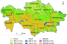
Fig. 1
Location and types of land use in northern Kazakhstan"

Tab. 1
Vegetation index formulas"
| 植被指数 | 公式 | 参考文献 |
|---|---|---|
| NDVI | | [ |
| EVI2 | | [ |
| WDRVI | | [ |
| SANDVI | | [ |
| WDRVIgreen | | [ |
| CIgreen | | [ |
| DVI | | [ |
| OSAVI | | [ |
| NMDI | | [ |
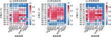
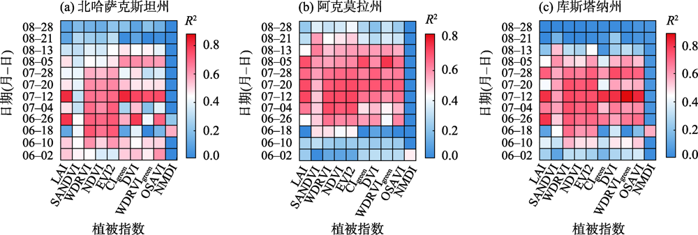
Fig. 2
Coefficient of determination between the vegetation index and the yield per unit of spring wheat in northern Kazakhstan"
Tab. 2
Optimal vegetation index and best estimated date of spring wheat yield in northern Kazakhstan"
| 地名 | 最优植被指数(排名前5位) | 最佳观测日期(月-日) | R2 | RMSE/kg |
|---|---|---|---|---|
| 北哈萨克斯坦州 | CIgreen | 07-12 | 0.83 | 131.8 |
| LAI | 07-12 | 0.82 | 135.5 | |
| LAI | 06-26 | 0.80 | 143.0 | |
| DVI | 07-12 | 0.77 | 153.6 | |
| OSAVI | 07-12 | 0.76 | 155.3 | |
| 阿克莫拉州 | WDRVIgreen | 08-05 | 0.80 | 137.5 |
| EVI2 | 07-12 | 0.78 | 143.9 | |
| LAI | 07-12 | 0.77 | 145.0 | |
| WDRVI | 07-12 | 0.76 | 147.6 | |
| EVI2 | 07-20 | 0.76 | 148.2 | |
| 库斯塔纳州 | WDRVIgreen | 07-12 | 0.88 | 123.6 |
| OSAVI | 07-12 | 0.83 | 150.7 | |
| CIgreen | 07-12 | 0.81 | 157.5 | |
| DVI | 07-12 | 0.81 | 158.2 | |
| LAI | 06-26 | 0.80 | 163.7 |
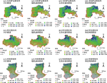
Fig. 3
Estimated annual average production of spring wheat yield in northern Kazakhstan from 2007 to 2016"

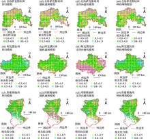
Fig. 4
Spatial validation of spring wheat yield estimation in northern Kazakhstan"


Fig. 5
Classification of the correlation between NPP and spring wheat yield"

| [1] | 李宁. 哈萨克斯坦小麦产业的发展与问题[J]. 粮食流通技术, 2013(2):37-42. |
| [ Li Ning. Study on Kazakhstan’s wheat industry and its problems[J]. Grain Distribution Technology, 2013(2):37-42. ] | |
| [2] | 马骏, 龚新蜀. 中亚国家粮食安全问题研究[J]. 世界农业, 2014(8):22-26. |
| [ Ma Jun, Gong Xinshu. Research on food security in Central Asian countries[J]. World Agriculture, 2014(8):22-26. ] | |
| [3] | 周清波. 国内外农情遥感现状与发展趋势[J]. 中国农业资源与区划, 2004, 25(5):12-17. |
| [ Zhou Qingbo. Status and tendency for development in remote sensing of agriculture situation[J]. Journal of China Agricultural Resources and Regional Planning, 2004, 25(5):12-17. ] | |
| [4] |
Anup K P, Lim C, Ramesh P S, et al. Crop yield estimation model for Iowa using remote sensing and surface parameters[J]. International Journal of Applied Earth Observation and Geoinformation, 2006, 8(1):26-33.
doi: 10.1016/j.jag.2005.06.002 |
| [5] | Michael S R. Assessment of millet yields and production in northern Burkina Faso using integrated NDVI from the AVHRR[J]. International Journal of Remote Sensing, 1992, 13(18):3871-3879. |
| [6] |
Michael S R. Operational yield forecast using AVHRR NDVI data: Reduction of environmental and inter-annual variability[J]. International Journal of Remote Sensing, 1997, 18(5):1059-1077.
doi: 10.1080/014311697218575 |
| [7] | 焦险峰, 杨邦杰, 裴志远, 等. 基于植被指数的作物产量监测方法研究[J]. 农业工程学报, 2005, 21(4):104-108. |
| [ Jiao Xianfeng, Yang Bangjie, Pei Zhiyuan, et al. Monitoring crop yield using NOAA/AVHRR based vegetation indices[J]. Transactions of the Chinese Society of Agricultural Engineering, 2005, 21(4):104-108. ] | |
| [8] |
Tuvdendorj B. Determination of appropriate remote sensing indices for spring wheat yield estimation in Mongolia[J]. Remote Sensing, 2019, 11(21):2568-2570.
doi: 10.3390/rs11212568 |
| [9] | 李军玲, 郭其乐, 彭记永. 基于MODIS数据的河南省冬小麦产量遥感估算模型[J]. 生态环境学报, 2012, 21(10):1665-1669. |
| [ Li Junling, Guo Qile, Peng Jiyong. Remote sensing estimation model of Henan Province winter wheat yield based on MODIS data[J]. Ecology and Environmental Sciences, 2012, 21(10):1665-1669. ] | |
| [10] | 谭昌伟. 基于开花期卫星遥感数据的大田小麦估产方法比较[J]. 中国农业科学, 2017, 50(16):3101-3109. |
| [ Tan Changwei. Comparison of the methods for predicting wheat yield based on satellite remote sensing data at anjournal[J]. Scientia Agricultura Sinica, 2017, 50(16):3101-3109. ] | |
| [11] | Uno Y. Artificial neural networks to predict corn yield from compact airborne spectrographic imager data[J]. Computers and Electronics in Agriculture, 2005, 47(2):149-161. |
| [12] | 王恺宁, 王修信. 多植被指数组合的冬小麦遥感估产方法研究[J]. 干旱区资源与环境, 2017, 31(7):44-49. |
| [ Wang Kaining, Wang Xiuxin. Research on winter wheat yield estimtion with the multipy remote sensing vegetation index combination[J]. Journal of Arid Land Resources and Environment, 2017, 31(7):44-49. ] | |
| [13] | 徐春萌. 基于DSSAT作物模型的中美大豆主产区单产模拟与验证[J]. 农业工程学报, 2021, 37(3):132-139. |
| [ Xu Chunmeng. Simulations and validations of the soybean yields per unit area using DSSAT crop model in the major soybean producing areas of China and America[J]. Transactions of the Chinese Society of Agricultural Engineering, 2021, 37(3):132-139. ] | |
| [14] | 赵军. 基于净初级生产力的春小麦生产潜力及估产研究——以甘肃省白银区为例[J]. 干旱地区农业研究, 2015, 33(1):199-204. |
| [ Zhao Jun. Potential productivity and yield estimation of spring wheat based on a net primary production model: Taking Baiyin District in Gansu Province as an example[J]. Agricultural Research in the Arid Areas, 2015, 33(1):199-204. ] | |
| [15] |
Bolton D K, Friedl M A. Forecasting crop yield using remotely sensed vegetation indices and crop phenology metrics[J]. Agricultural and Forest Meteorology, 2013, 173:74-84.
doi: 10.1016/j.agrformet.2013.01.007 |
| [16] |
Leroux L. Crop monitoring using vegetation and thermal indices for yield estimates: Case study of a rainfed cereal in semi-arid west Africa[J]. IEEE Journal of Selected Topics in Applied Earth Observations and Remote Sensing, 2016, 9(1):347-362.
doi: 10.1109/JSTARS.4609443 |
| [17] | 郭锐. 山东省冬小麦单产监测与预报方法研究[J]. 农业机械学报, 2020, 51(7):156-163. |
| [ Guo Rui. Monitoring and forecasting method of winter wheat yield in Shandong Province[J]. Transactions of the Chinese Society for Agricultural Machinery, 2020, 51(7):156-163. ] | |
| [18] | 安秦. 长春地区玉米产量遥感估算方法研究[D]. 长春: 吉林大学, 2018. |
| [ An Qin. Research on methods of maize yield estimation by remote sensing in Changchun region[D]. Changchun: Jilin University, 2018. ] | |
| [19] | 曾妍, 王迪, 赵小娟, 等. 基于支持向量回归的关中平原冬小麦估产研究[J]. 中国农业信息, 2019, 31(6):10-20. |
| [ Zeng Yan, Wang Di, Zhao Xiaojuan, et al. Study on yield prediction of winter wheat in Guanzhong Plain based on SVR[J]. China Agricultural Informatics, 2019, 31(6):10-20. ] | |
| [20] | 黄健熙, 马鸿元, 田丽燕, 等. 基于时间序列LAI和ET同化的冬小麦遥感估产方法比较[J]. 农业工程学报, 2015, 31(4):197-203. |
| [ Huang Jianxi, Ma Hongyuan, Tian Liyan, et al. Comparison of remote sensing yield estimation methods for winter wheat based on assimilating time-sequence LAI and ET[J]. Transactions of the Chinese Society of Agricultural Engineering, 2015, 31(4):197-203. ] | |
| [21] | 马鸿元, 黄健熙, 黄海, 等. 基于历史气象资料和WOFOST模型的区域产量集合预报[J]. 农业机械学报, 2018, 49(9):257-266. |
| [ Ma Hongyuan, Huang Jianxi, Huang Hai, et al. Ensemble forecasting of regional yield of winter wheat based on WOFOST model using historical metrological dataset[J]. Transactions of the Chinese Society for Agricultural Machinery, 2018, 49(9):257-266. ] | |
| [22] | 杨练兵, 郑宏伟, 罗格平, 等. 基于遗传算法优化BP神经网络的土壤盐渍化反演[J]. 地理与地理信息科学, 2021, 37(2):21-37. |
| [ Yang Lianbing, Zheng Hongwei, Luo Geping, et al. Retrieval of soil salinity content based on BP neural network optimized by genetic algorithm[J]. Geography and Geo-Information Science, 2021, 37(2):21-37. ] | |
| [23] |
Dara A. Mapping the timing of cropland abandonment and recultivation in northern Kazakhstan using annual Landsat time series[J]. Remote Sensing of Environment, 2018, 213:49-60.
doi: 10.1016/j.rse.2018.05.005 |
| [24] | Guo H. Determining variable weights for an optimal scaled drought condition index (OSDCI): Evaluation in Central Asia[J]. Remote Sensing of Environment, 2019, 231:1-17. |
| [25] |
Yin H. Monitoring fire regimes and assessing their driving factors in Central Asia[J]. Journal of Arid Land, 2021, 13(5):500-515.
doi: 10.1007/s40333-021-0008-2 |
| [26] | 韩其飞, 罗格平, 白洁, 等. 基于多期数据集的中亚五国土地利用/覆盖变化分析[J]. 干旱区地理, 2012, 35(6):909-918. |
| [ Han Qifei, Luo Geping, Bai Jie, et al. Characteristics of land use and cover change in Central Asia in recent 30 years[J]. Arid Land Geography, 2012, 35(6):909-918. ] | |
| [27] | Yao F. Estimation of maize yield by using a process-based model and remote sensing data in the Northeast China Plain[J]. Physics and Chemistry of the Earth, 2015, 87:142-152. |
| [28] |
Mkhabela M S, Mashinini N N. Early maize yield forecasting in the four agro-ecological regions of Swaziland using NDVI data derived from NOAA’s-AVHRR[J]. Agricultural and Forest Meteorology, 2005, 129(1):1-9.
doi: 10.1016/j.agrformet.2004.12.006 |
| [29] | 田艳君, 石莹, 帅艳民, 等. 基于遥感时序特征的地表覆被信息提取[J]. 干旱区地理, 2021, 44(2):450-459. |
| [ Tian Yanjun, Shi Ying, Shuai Yanmin, et al. Land cover information retrieval from temporal features based remote sensing images[J]. Arid Land Geography, 2021, 44(2):450-459. ] | |
| [30] | 王华, 杨乾鹏, 田云杰, 等. 基于多时相Landsat影像的中亚地区植被覆盖遥感监测[J]. 干旱区地理, 2020, 43(4):1023-1032. |
| [ Wang Hua, Yang Qianpeng, Tian Yunjie, et al. Vegetation coverage monitoring in the Central Asian countries using multi-temporal Landsat images[J]. Arid Land Geography, 2020, 43(4):1023-1032. ] | |
| [31] |
Jiang Z. Development of a two-band enhanced vegetation index without a blue band[J]. Remote Sensing of Environment, 2008, 112(10):3833-3845.
doi: 10.1016/j.rse.2008.06.006 |
| [32] |
Gitelson A A. Wide dynamic range vegetation index for remote quantification of biophysical characteristics of vegetation[J]. Journal of Plant Physiology, 2004, 161(2):165-173.
pmid: 15022830 |
| [33] |
Gu Y. NDVI saturation adjustment: A new approach for improving cropland performance estimates in the Greater Platte River Basin, USA[J]. Ecological Indicators, 2013, 30:1-6.
doi: 10.1016/j.ecolind.2013.01.041 |
| [34] |
Gitelson A A. Remote estimation of crop gross primary production with Landsat data[J]. Remote Sensing of Environment, 2012, 121:404-414.
doi: 10.1016/j.rse.2012.02.017 |
| [35] | Gitelson A A. Remote estimation of canopy chlorophyll content in crops[J]. Geophysical Research Letters, 2005, 32(8):1-4. |
| [36] | Mirchooli F. Spatial distribution dependency of soil organic carbon content to important environmental variables[J]. Ecological Indicators, 2020, 116:1-5. |
| [37] |
Jin Y. Remote sensing-based biomass estimation and its spatio-temporal variations in temperate grassland, northern China[J]. Remote Sensing, 2014, 6(2):1496-1513.
doi: 10.3390/rs6021496 |
| [38] | 高煜堃. 基于机器学习及多源数据的亚热带典型区域森林地上生物量估测研究[D]. 杭州: 浙江农林大学, 2018. |
| [ Gao Yukun. Aboveground forest biomass estimation based on machine learning algorithms and multi-source data in a typical subtropical region[D]. Hangzhou: Zhejiang Agriculture and Forestry University, 2018. ] | |
| [39] | 郜燕芳, 李俊明, 刘东伟, 等. 基于随机森林模型的城市不透水面提取研究——以呼和浩特市为例[J]. 冰川冻土, 2018, 40(4):828-836. |
| [ Gao Yanfang, Li Junming, Liu Dongwei, et al. Research on extraction of urban impervious surface based on random forest model: A case study in Hohhot[J]. Journal of Glaciology and Geocryology, 2018, 40(4):828-836. ] | |
| [40] | 徐新刚, 吴炳方, 蒙继华, 等. 农作物单产遥感估算模型研究进展[J]. 农业工程学报, 2008(2):290-298. |
| [ Xu Xingang, Wu Bingfang, Meng Jihua, et al. Research advances in crop yield estimation models based on remote sensing[J]. Transactions of the Chinese Society of Agricultural Engineering, 2018(2):290-298. ] | |
| [41] | 徐逸, 董轩妍, 王俊杰. 4种机器学习模型反演太湖叶绿素a浓度的比较[J]. 水生态学杂志, 2019, 40(4):48-57. |
| [ Xu Yi, Dong Xuanyan, Wang Junjie. Use of remote multispectral imaging to monitor chlorophyll-a in Taihu Lake: A comparison of machine learning models[J]. Journal of Hydroecology, 2019, 40(4):48-57. ] |
| [1] | BAI He, MING Yisen, LIU Qihang, HUANG Chang. Downscaling of GPM satellite precipitation data in the Yellow River Basin based on MGWR model [J]. Arid Land Geography, 2023, 46(7): 1052-1062. |
| [2] | NI Honghong, MA Qiang, BU Yuankun, YANG Xiaoxuan, LI Weizhong. Spatiotemporal distribution pattern evolution and influencing factors of forestry enterprises in Shaanxi Province [J]. Arid Land Geography, 2023, 46(12): 2098-2110. |
| [3] | CUI Jintao, Mamat SAWUT. Estimation of leaf water content in upland cotton based on feature band selection and machine learning [J]. Arid Land Geography, 2023, 46(11): 1836-1847. |
| [4] | WEI Huimin, JIA Keli, ZHANG Xu, ZHANG Junhua. Prediction of soil salinity based on machine learning and multispectral remote sensing in Yinchuan Plain [J]. Arid Land Geography, 2023, 46(1): 103-114. |
| [5] | HE Junqi,WEI Yan,GAO Wande,CHEN Yunfei,MA Yandong,LIU Xiuhua. Temporal and spatial variation of vegetation NDVI and its response to climatic factors in the southeastern margin of Mu Us Sandy Land [J]. Arid Land Geography, 2022, 45(5): 1523-1533. |
| [6] | ZHAO Shuang,DING Jianli,HAN Lijing,HUANG Shuai,GE Xiangyu. Response analysis and modeling of microwave dielectric properties of typical saline soil in Xinjiang [J]. Arid Land Geography, 2022, 45(5): 1534-1546. |
| [7] | LIU Xuhui,BAI Yungang,CHAI Zhongping,ZHANG Jianghui,DING Bangxin,JIANG Zhu. Inversion and validation of soil salinity based on multispectral remote sensing in typical oasis cotton field in spring [J]. Arid Land Geography, 2022, 45(4): 1165-1175. |
| [8] | DAI Yunhao,GUAN Yao,ZHANG Qinkai,SUN Junjie,HE Xinghong. Remote sensing monitoring and temporal and spatial characteristics of soil salinization in Aral Reclamation Area [J]. Arid Land Geography, 2022, 45(4): 1176-1185. |
| [9] | CHENG Danni,WANG Yingqi,CHENG Yongxiang,HUANG Jingfeng. Vegetation-water vapor-land surface temperature correlation analysis of typical deserts and oases in Xinjiang [J]. Arid Land Geography, 2022, 45(2): 456-466. |
| [10] | REN Liqing. Spatiotemporal change and driving force of vegetation in Ebinur Lake Basin [J]. Arid Land Geography, 2022, 45(2): 467-477. |
| [11] | YE Jingyun,WU Bo,JIA Xiaohong,FEI Bingqiang,GAO Junliang,CHENG Long,PANG Yingjun,YAO Bin,KONG Deyong. Estimation of aboveground biomass of sparse desert vegetation based on remote sensing techniques in hyper-arid area [J]. Arid Land Geography, 2022, 45(2): 478-487. |
| [12] | CHEN Shuo,DUAN Weili,LI Xiaoyang. Runoff changes of the Aksu River under different exploitation scenarios in the upper river [J]. Arid Land Geography, 2021, 44(5): 1365-1372. |
| [13] | ZHU Shuzhen,HUANG Farong,LI Lanhai. Drought characteristics and its risk assessment across Pakistan [J]. Arid Land Geography, 2021, 44(4): 1058-1069. |
| [14] | HU Guigui,YANG Fenli,YANG Lian’an,ZHENG Yurong,WANG Hui,CHEN Weijun,LI Yali. Spatial prediction modeling of soil organic matter content based on principal components and machine learning [J]. Arid Land Geography, 2021, 44(4): 1114-1124. |
| [15] | WEN Boqing,LIU Rong,PANG Guowei,ZHANG Quan. Downscaling study of GPM satellite precipitation data: A case study of Shaanxi Province [J]. Arid Land Geography, 2021, 44(3): 786-795. |
|
||