- Aug. 13, 2025
Arid Land Geography ›› 2022, Vol. 45 ›› Issue (4): 1155-1164.doi: 10.12118/j.issn.1000-6060.2021.551
• Earth Information Sciences • Previous Articles Next Articles
ZHAO Qiaozhen1,2( ),DING Jianli1,2,3(),HAN Lijing1,2,JIN Xiaoye1,2,HAO Jianping4
Received:2021-11-22
Revised:2022-01-19
Online:2022-07-25
Published:2022-08-11
Contact:
Jianli DING
E-mail:zhaoqz1026@163.com;watarid@xju.edu.cn
ZHAO Qiaozhen,DING Jianli,HAN Lijing,JIN Xiaoye,HAO Jianping. Exploring the application of MODIS and Landsat spatiotemporal fusion images in soil salinization: A case of Ugan River-Kuqa River Delta Oasis[J].Arid Land Geography, 2022, 45(4): 1155-1164.
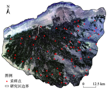
Fig. 1
Distribution of sampling points in the study area"

Tab. 1
Remote sensing image data information"
| 波段名称 | Landsat波段 | 分辨率/m | 波谱范围/nm | 波段名称 | MODIS波段 | 分辨率/m | 波谱范围/nm |
|---|---|---|---|---|---|---|---|
| Blue | 2 | 30 | 450~515 | Blue | 3 | 500 | 459~479 |
| Green | 3 | 30 | 525~600 | Green | 4 | 500 | 545~565 |
| Red | 4 | 30 | 630~680 | Red | 1 | 500 | 620~670 |
| NIR | 5 | 30 | 845~885 | NIR | 2 | 500 | 841~876 |
| SWIR1 | 6 | 30 | 1560~1651 | SWIR1 | 5 | 500 | 1628~1652 |
| SWIR2 | 7 | 30 | 2100~2300 | SWIR2 | 6 | 500 | 2105~2155 |
Tab. 2
Variable indices and calculation formulas involved in inversion"
| 指数 | 公式 |
|---|---|
| 归一化植被指数(NDVI)[ | (NIR-Red)/(NIR+Red) |
| 增强型植被指数(EVI)[ | 2.5×[(NIR-Red)/(NIR+6Red-7.5Blue+1)] |
| 扩展差值植被指数(EDVI)[ | NIR+SWIR1-Red |
| 比值植被指数(RVI)[ | NIR/Green |
| 扩展的归一化植被指数(ENDVI)[ | (NIR+SWIR2-Red)/(NIR+SWIR2+Red) |
| 扩展的增强型植被指数(EEVI)[ | 2.5×[(NIR+SWIR1-Red)/(NIR+SWIR1+6Red-7.5Blue+1)] |
| 盐分指数(SIT)[ | (Red/NIR)×100 |
| 盐分指数(SI)[ | (Blue×Red)0.5 |
| 盐分指数(SI1)[ | (Green×Red)0.5 |
| 盐分指数(SI2)[ | (Green2+Red2+NIR2)0.5 |
| 盐分指数(SI3)[ | (Red2+Green2)0.5 |
| 归一化盐分指数(NDSI)[ | (Red-NIR)/(Red+NIR) |
| 盐分指数(S1)[ | Blue/Red |
| 盐分指数(S2)[ | (Blue-Red)/(Blue+Red) |
| 盐分指数(S3)[ | (Green×Red)/Blue |
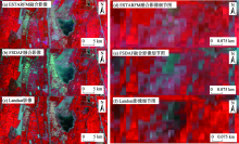
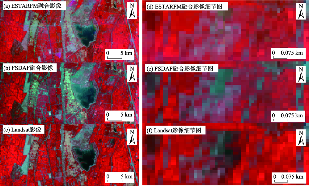
Fig. 2
Partial comparison of false color synthesized from fusion image and verification image"
Tab. 3
Analysis of the reflectance characteristics of the fusion image and the verification image band"
| 模型 | Blue | Green | Red | NIR | SWIR1 | SWIR2 |
|---|---|---|---|---|---|---|
| ESTARFM 模型 | y=-128.8+1.0848x R2=0.6443 | y=-113.7+1.0552x R2=0.6996 | y=-272.8+1.1213x R2=0.8066 | y=-91.10+1.0880x R2=0.7496 | y=407.07+0.8961x R2=0.6358 | y=-59.69+1.0485x R2=0.8444 |
| FSDAF 模型 | y=-263.2+1.2043x R2=0.4959 | y=-411.1+1.2268x R2=0.5525 | y=-521.9+1.2656x R2=0.6999 | y=-11.97+1.1058x R2=0.6202 | y=445.28+0.9519x R2=0.4909 | y=-267.6+1.1818x R2=0.7493 |
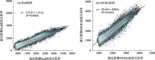
Fig. 3
2D scatter plot of ESTARFM model fusion image and verification image"
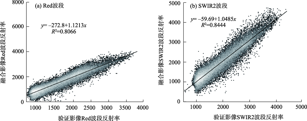
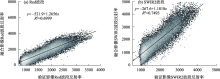
Fig. 4
2D scatter plot of FSDAF model fusion image and verification image"

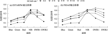
Fig. 5
Reflectance spectrum curves of soils with different salinities in spatio-temporal fusion images"

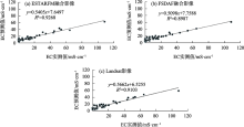
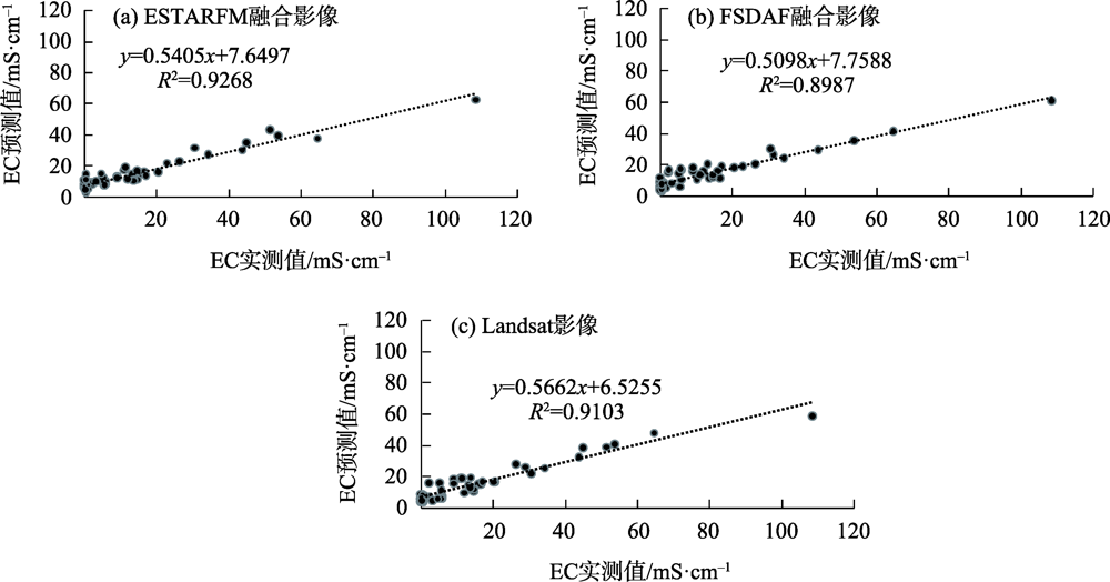
Fig. 6
EC values fitting based on 3 kinds of image"
| [1] | 吴亚坤, 刘广明, 苏里坦, 等. 多源数据的区域土壤盐渍化精确评估[J]. 光谱学与光谱分析, 2018, 38(11): 3528-3533. |
| [ Wu Yakun, Liu Guangming, Su Litan, et al. Accurate evaluation of regional soil salinization using multi-source data[J]. Spectroscopy and Spectral Analysis, 2018, 38(11): 3528-3533. ] | |
| [2] |
Han L J, Ding J L, Zhang J Y, et al. Precipitation events determine the spatiotemporal distribution of playa surface salinity in arid regions: Evidence from satellite data fused via the enhanced spatial and temporal adaptive reflectance fusion model[J]. Catena, 2021, 206: 105546, doi: 10.1016/J.CATENA.2021.105546.
doi: 10.1016/J.CATENA.2021.105546 |
| [3] |
Zhu X L, Chen J, Gao F, et al. An enhanced spatial and temporal adaptive reflectance fusion model for complex heterogeneous regions[J]. Remote Sensing of Environment, 2010, 114(11): 2610-2623.
doi: 10.1016/j.rse.2010.05.032 |
| [4] | 黄波. 时空遥感影像融合研究的进展与趋势[J]. 四川师范大学学报(自然科学版), 2020, 43(4): 427-434, 424. |
| [ Huang Bo. Research progress and trend of spatial and temporal remote sensing image fusion[J]. Journal of Sichuan Normal University (Natural Science Edition), 2020, 43(4): 427-434, 424. ] | |
| [5] |
Hilker T, Wulder M A, Coops N C, et al. A new data fusion model for high spatial-and temporal-resolution mapping of forest disturbance based on Landsat and MODIS[J]. Remote Sensing of Environment, 2009, 113(8): 1613-1627.
doi: 10.1016/j.rse.2009.03.007 |
| [6] |
Zhao Y Q, Huang B, Song H H. A robust adaptive spatial and temporal image fusion model for complex land surface changes[J]. Remote Sensing of Environment, 2018, 208: 42-62.
doi: 10.1016/j.rse.2018.02.009 |
| [7] |
Meng L H, Liu H J, Ustin S L, et al. Assessment of FSDAF accuracy on cotton yield estimation using different MODIS products and landsat based on the mixed degree index with different surroundings[J]. Sensors (Basel, Switzerland), 2021, 21(15): 5184, doi: 10.3390/S21155184.
doi: 10.3390/S21155184 |
| [8] | 马倩倩, 董博, 许旺旺, 等. 干旱区耕地质量等级评价及土壤养分与盐渍化的分析研究--以民勤绿洲为例[J]. 干旱区地理, 2021, 44(2): 514-524. |
| [ Ma Qianqian, Dong Bo, Xu Wangwang, et al. Evaluation of cultivated land quality and analysis of soil nutrients and in arid areas: Taking Minqin Oasis as an example[J]. Arid Land Geography, 2021, 44(2): 514-524. ] | |
| [9] | 柳菲, 陈沛源, 于海超, 等. 民勤绿洲不同土地利用类型下土壤水盐的空间分布特征分析[J]. 干旱区地理, 2020, 43(2): 406-414. |
| [ Liu Fei, Chen Peiyuan, Yu Haichao, et al. Spatial distribution characteristics of soil water and salt under different land use types in Minqin Oasis[J]. Arid Land Geography, 2020, 43(2): 406-414. ] | |
| [10] | 张晓川, 王杰. 基于遥感时空融合的升金湖湿地生态水文结构分析[J]. 遥感技术与应用, 2020, 35(5): 1109-1117. |
| [ Zhang Xiaochuan, Wang Jie. The analysis of eco-hydrological structure of Shengjin Lake Wetland based on spatial and temporal fusion technology of remote sensing[J]. Remote Sensing Technology and Application, 2020, 35(5): 1109-1117. ] | |
| [11] | 李超, 李雪梅, 田亚林, 等. 温度植被干旱指数时空融合模型对比[J]. 遥感技术与应用, 2020, 35(4): 832-844. |
| [ Li Chao, Li Xuemei, Tian Yalin, et al. Time and space fusion model comparison of temperature vegetation drought index[J]. Remote Sensing Technology and Application, 2020, 35(4): 832-844. ] | |
| [12] | 石晨烈, 王旭红, 张萌. 3种时空融合算法在洪水监测中的适用性研究[J]. 国土资源遥感, 2020, 32(2): 111-119. |
| [ Shi Chenlie, Wang Xuhong, Zhang Meng. Analysis of the applicability of three remote sensing spatiotemporal fusion algorithms in flood monitoring[J]. Remote Sensing for Land and Resources, 2020, 32(2): 111-119. ] | |
| [13] | 王爽, 王承武, 张飞云. 基于FSDAF模型的干旱区典型绿洲城市夏季地表热岛效应时空演变研究[J]. 干旱区地理, 2021, 44(1): 118-130. |
| [ Wang Shuang, Wang Chengwu, Zhang Feiyun. Spatiotemporal variations of the summer daytime surface urban heat island of oasis city in arid area based on FSDAF model[J]. Arid Land Geography, 2021, 44(1): 118-130. ] | |
| [14] | 何珍珍, 王宏卫, 杨胜天, 等. 渭干河-库车河绿洲景观生态安全时空分异及格局优化[J]. 生态学报, 2019, 39(15): 5473-5482. |
| [ He Zhenzhen, Wang Hongwei, Yang Shengtian, et al. Spatial-temporal differentiation and pattern optimization of land scape ecological security in the Ugan-Kuqa River oasis[J]. Acta Ecologica Sinica, 2019, 39(15): 5473-5482. ] | |
| [15] | 马国林, 丁建丽, 韩礼敬, 等. 基于变量优选与机器学习的干旱区湿地土壤盐渍化数字制图[J]. 农业工程学报, 2020, 36(19): 124-131. |
| [ Ma Guolin, Ding Jianli, Han Lijing, et al. Digital mapping of soil salinization in arid area wetland based on variable optimized selection and machine learning[J]. Transactions of the Chinese Society of Agricultural Engineering, 2020, 36(19): 124-131. ] | |
| [16] |
Lobell D B, Lesch S M, Corwin D L, et al. Regional-scale assessment of soil salinity in the Red River Valley using multi-year MODIS EVI and NDVI[J]. Journal of Environmental Quality, 2010, 39(1): 35-41.
doi: 10.2134/jeq2009.0140 pmid: 20048292 |
| [17] | 郑裕东, 徐云成, 严海军, 等. 基于近地遥感系统的小麦玉米冠层RVI和NDVI获取影响因素分析[J]. 光谱学与光谱分析, 2021, 41(8): 2578-2585. |
| [ Zheng Yudong, Xu Yuncheng, Yan Haijun, et al. Analysis of influencing factors in wheat/maize canopy RVI and NDVI acquisition using ground-based remote sensing system[J]. Spectroscopy and Spectral Analysis, 2021, 41(8): 2578-2585. ] | |
| [18] | 魏阳, 丁建丽, 王飞. 基于Landsat OLI的绿洲灌区土壤盐度最优预测尺度分析[J]. 中国农业科学, 2017, 50(15): 2969-2982. |
| [ Wei Yang, Ding Jianli, Wang Fei. Optimal scale analysis of soil salinity prediction in oasis irrigated area of arid land based on Landsat OLI[J]. Scientia Agricultura Sinica, 2017, 50(15): 2969-2982. ] | |
| [19] | 王飞, 丁建丽, 魏阳, 等. 基于Landsat系列数据的盐分指数和植被指数对土壤盐度变异性的响应分析--以新疆天山南北典型绿洲为例[J]. 生态学报, 2017, 37(15): 5007-5022. |
| [ Wang Fei, Ding Jianli, Wei Yang, et al. Sensitivity analysis of soil salinity and vegetation indices to detect soil salinity variation by using Landsat series images: Applications in different oases in Xinjiang, China[J]. Acta Ecologica Sinica, 2017, 37(15): 5007-5022. ] | |
| [20] | 陈红艳, 赵庚星, 陈敬春, 等. 基于改进植被指数的黄河口区盐渍土盐分遥感反演[J]. 农业工程学报, 2015, 31(5): 107-114. |
| [ Chen Hongyan, Zhao Gengxing, Cheng Jingchun, et al. Remote sensing inversion of saline soil salinity based on modified vegetation index in estuary area of Yellow River[J]. Transactions of the Chinese Society of Agricultural Engineering, 2015, 31(5): 107-114. ] | |
| [21] | 冯娟, 丁建丽, 杨爱霞, 等. 干旱区土壤盐渍化信息遥感建模[J]. 干旱地区农业研究, 2018, 36(1): 266-273. |
| [ Fen Juan, Ding Jianli, Yang Aixia, et al. Remote sensing modeling of soil salinization information in arid areas[J]. Agricultural Research in the Arid Areas, 2018, 36(1): 266-273. ] | |
| [22] | 樊彦国, 张维康, 刘敬一. 基于植被指数-盐分指数特征空间的黄河三角洲盐渍化遥感监测研究[J]. 山东农业科学, 2016, 48(5): 137-141. |
| [ Fan Yanguo, Zhang Weikang, Liu Jingyi. Remote sensing monitoring model of soil salinization in the Yellow River Delta Zone based on vegetation index-salt index feature space[J]. Shandong Agricultural Sciences, 2016, 48(5): 137-141. ] | |
| [23] | 曹雷, 丁建丽, 玉米提·哈力克, 等. 基于国产高分一号卫星数据的区域土壤盐渍化信息提取与建模[J]. 土壤学报, 2016, 53(6): 1399-1409. |
| [ Cao Lei, Ding Jianli, Halik Umut, et al. Extraction and modeling of regional soil salinization based on data from GF-1 satellite[J]. Acta Pedologica Sinica, 2016, 53(6): 1399-1409. ] | |
| [24] |
Kamh G M E, Ismael B, Oguchi C T. Pore size distribution and wall side orientation controlling salt susceptibility index “SSI” and weathering rate of stratified pharaonic rock art[J]. Restoration of Buildings and Monuments, 2013, 19(5): 341-362.
doi: 10.1515/rbm-2013-6617 |
| [25] |
Sahana M, Rehman S, Patel P P, et al. Assessing the degree of soil salinity in the Indian Sundarban Biosphere Reserve using measured soil electrical conductivity and remote sensing data-derived salinity indices[J]. Arabian Journal of Geosciences, 2020, 13(24): 1289, doi: 10.1007/S12517-020-06310-W.
doi: 10.1007/S12517-020-06310-W |
| [26] |
Nguyen K A, Liou Y A, Tran H P, et al. Soil salinity assessment by using near-infrared channel and vegetation soil salinity index derived from Landsat 8 OLI data: A case study in the Tra Vinh Province, Mekong Delta, Vietnam[J]. Progress in Earth and Planetary Science, 2020, 7(1): 1-16.
doi: 10.1186/s40645-019-0311-0 |
| [27] | 马国林. 耦合多源传感器与机器学习算法的渭-库绿洲土壤盐分估测[D]. 乌鲁木齐: 新疆大学, 2021. |
| [ Ma Guolin. Estimation of soil salinity in Weigan-Kuqa Oasis coupling multi-source sensors and machine learning algorithms[D]. Urumqi: Xinjiang University, 2021. ] |
| [1] | MENG Huimin, ZHAN Chesheng, HU Shi, LIN Zhonghui. Research progress on simulation of soil water-salt transport in large-scale irrigation districts [J]. Arid Land Geography, 2024, 47(9): 1566-1576. |
| [2] | XIE Junbo, WANG Xingpeng, HE Shuai, LIU Yang, ZHONG Zhibo, LI Yan, HONG Guojun. Soil salinity inversion in the Shajingzi irrigation district based on spectral index modeling [J]. Arid Land Geography, 2024, 47(7): 1199-1209. |
| [3] | ZHAO Guobing, ZHENG Jianghua, WANG Lei, GAO Jian, LUO Lei, Nigela TUERXUN, HAN Wanqiang, GUAN Jingyun. Remote sensing extraction of jujube planting area in Xinjiang based on RF classification optimization and SNIC clustering [J]. Arid Land Geography, 2024, 47(6): 1004-1014. |
| [4] | WANG Anqi, ZHANG Yu, LIU Jiawei, ZHAO Wei, LIU Xinyu, LI Kai. Vegetation community diversity and spatial distribution pattern in Ganjiahu Saxoul National Nature Reserve, Xinjiang [J]. Arid Land Geography, 2024, 47(11): 1841-1851. |
| [5] | SHI Cong, CHEN Lihan, ZHANG Yifei, HE Shuai, XIE Haixia. Soil salinization characteristics of cultivated land in Xiaohaizi Irrigation Area of Xinjiang [J]. Arid Land Geography, 2023, 46(8): 1314-1323. |
| [6] | LI Ke, DING Jianli, HAN Lijing, GE Xiangyu, GU Yongsheng, ZHOU Qian, LYU Yangxia. Digital mapping of soil salinization in a typical oasis based on PlanetScope images [J]. Arid Land Geography, 2023, 46(8): 1291-1302. |
| [7] | JIANG Lei, LIU Xiaolong, GUO Shuai, HE Liang, XING Jianlei, GUO Junjie. Evaluation of soil salinization susceptibility based on Logistic regression analysis: A case of Tarim irrigation area in southern Xinjiang [J]. Arid Land Geography, 2023, 46(11): 1858-1867. |
| [8] | ZHANG Juan, YAO Xiaojun, LI Jing, WANG Xiaoyan. Agricultural drought research based on multi-source remote sensing data in Gansu Province [J]. Arid Land Geography, 2023, 46(1): 11-22. |
| [9] | Mihray MOYIDIN, Mamat SAWUT, LI Jinzhao. Extraction of cotton planting area based on Sentinel-2 time series data and phenological characteristics [J]. Arid Land Geography, 2022, 45(6): 1847-1859. |
| [10] | PAN Qun,SHI Haiyang,ZHANG Wenqiang,LUO Geping,CHEN Chunbo. Spatiotemporal distribution of rat population density in grassland on the north slope of Tianshan Mountains based on Cubist model [J]. Arid Land Geography, 2022, 45(4): 1200-1211. |
| [11] | DAI Yunhao,GUAN Yao,ZHANG Qinkai,SUN Junjie,HE Xinghong. Remote sensing monitoring and temporal and spatial characteristics of soil salinization in Aral Reclamation Area [J]. Arid Land Geography, 2022, 45(4): 1176-1185. |
| [12] | XU Li’na,SHEN Yanbo,FENG Zhen,YE Hu. Applicability research and integrated application of various correction methods for wind speed forecast in a wind farm [J]. Arid Land Geography, 2022, 45(4): 1114-1124. |
| [13] | JIANG Li,WEI Tianxing,LI Yiran,WEI Anqi. Effects of topographical factors on tree species distribution of shelter forest in Loess hilly region of northern Shaanxi [J]. Arid Land Geography, 2021, 44(6): 1763-1771. |
| [14] | ZHAO Yongyu,Alimujiang KASIM,GAO Pengwen,LIANG Hongwu. Quantitative analysis of urban expansion and response factors in Urumqi City based on random forest algorithm and geographical detector [J]. Arid Land Geography, 2021, 44(6): 1729-1739. |
| [15] | BAO Qing-ling, DING Jian-li, WANG Jing-zhe, CAI Liang-hong. Hyperspectral detection of soil organic matter content based on random forest algorithm [J]. Arid Land Geography, 2019, 42(6): 1404-1414. |
| Viewed | ||||||||||||||||||||||||||||||||||||||||||||||||||
|
Full text 965
|
|
|||||||||||||||||||||||||||||||||||||||||||||||||
|
Abstract 636
|
|
|||||||||||||||||||||||||||||||||||||||||||||||||
Cited |
|
|||||||||||||||||||||||||||||||||||||||||||||||||
| Shared | ||||||||||||||||||||||||||||||||||||||||||||||||||
|
||