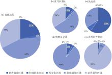
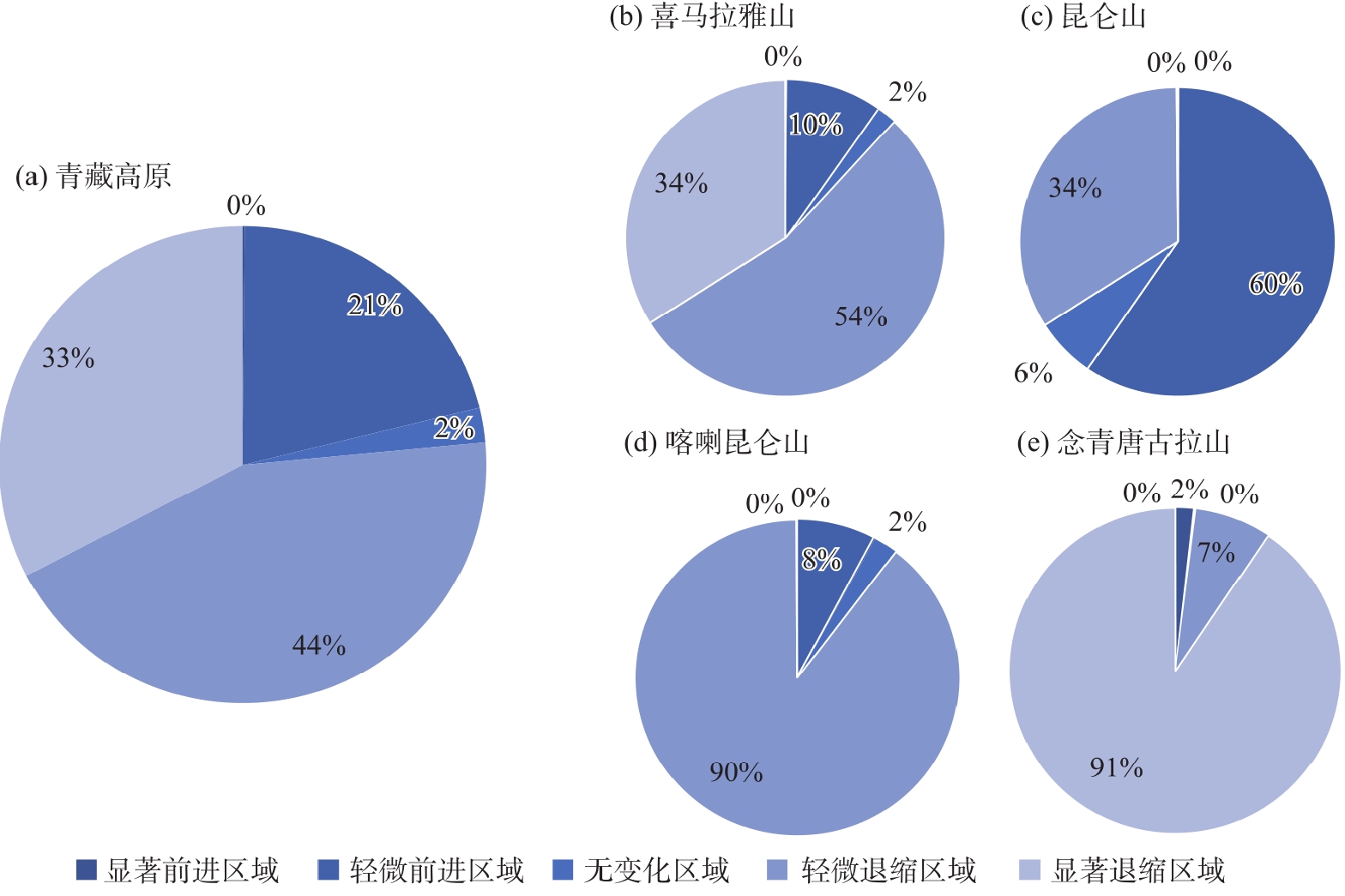
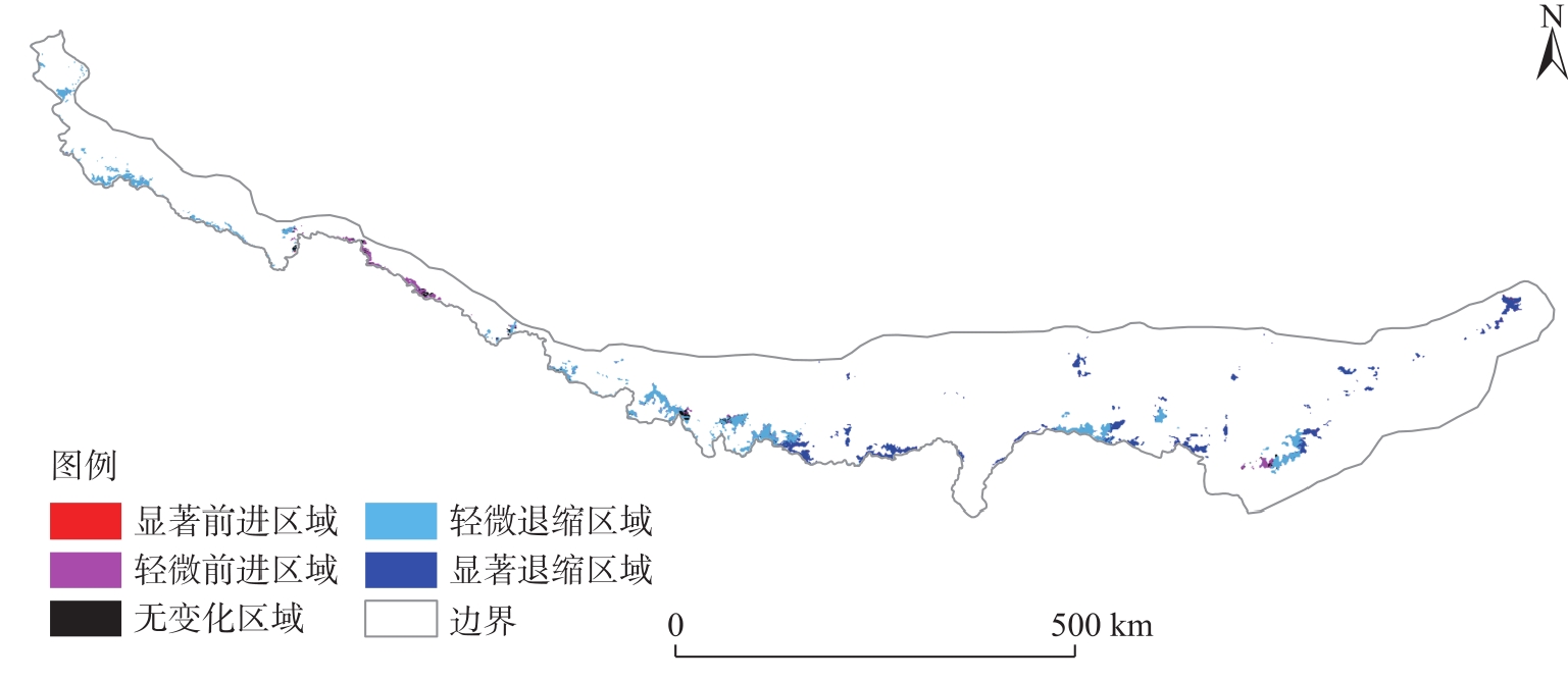
| [1] |
周玉杉. 基于多源遥感数据的青藏高原及其周边区域冰川物质平衡变化研究[J]. 地理与地理信息科学, 2019, 35(4): 142.
|
|
[Zhou Yushan. Investigation of glacier mass balance in the Qinghai-Tibet Plateau and its surroundings base on multi-source remote sencing data[J]. Geography and Geo-information Science, 2019, 35(4): 142. ]
|
| [2] |
顾云杨. 利用影像大地测量技术监测2000—2020年长江源冰川物质平衡变化[D]. 长沙: 中南大学, 2023.
|
|
[Gu Yunyang. Monitoring the changes of glacier mass balance in the source region of the Yangtze River from 2000 to 2020 with the imaging geodetic method[D]. Changsha: Central South University, 2023. ]
|
| [3] |
王宁练, 姚檀栋, 徐柏青, 等. 全球变暖背景下青藏高原及周边地区冰川变化的时空格局与趋势及影响[J]. 中国科学院院刊, 2019, 34(11): 1220-1232.
|
|
[Wang Ninglian, Yao Tandong, Xu Baiqing, et al. Spatiotemporal pattern, trend, and influence of glacier change in Tibetan Plateau and surroundings under global warming[J]. Bulletin of Chinese Academy of Sciences, 2019, 34(11): 1220-1232. ]
|
| [4] |
汪赢政, 李佳, 吴立新, 等. 1987—2018年祁连山冰川变化遥感监测及影响因子分析[J]. 冰川冻土, 2020, 42(2): 344-356.
doi: 10.7522/j.issn.1000-0240.2019.0080
|
|
[Wang Yingzheng, Li Jia, Wu Lixin, et al. Using remote sensing images to monitor the glacier changes in Qilian Mountains during 1987—2018 and analyzing the impact factors[J]. Journal of Glaciology and Geocryology, 2020, 42(2): 344-356. ]
doi: 10.7522/j.issn.1000-0240.2019.0080
|
| [5] |
冀琴, 张翠兰, 丁悦凯, 等. 基于多源遥感数据的珠峰自然保护区冰川监测研究[J]. 干旱区地理, 2023, 46(10): 1591-1601.
doi: 10.12118/j.issn.1000-6060.2022.624
|
|
[Ji Qin, Zhang Cuilan, Ding Yuekai, et al. Glacier monitoring in Qomolangma Nature Reserve based on multi-source remote sensing data[J]. Arid Land Geography, 2023, 46(10): 1591-1601. ]
doi: 10.12118/j.issn.1000-6060.2022.624
|
| [6] |
张裕. 1980—2020年唐古拉山冰川变化及其对气候波动的响应[D]. 大连: 辽宁师范大学, 2023.
|
|
[Zhang Yu. Glacier change in Tanggula Mountain and its response to climate fluctuation from 1980 to 2020[D]. Dalian: Liaoning Normal University, 2023. ]
|
| [7] |
田梦祺, 段克勤, 石培宏. 基于Google Earth Engine平台的青藏高原冰川变化研究——以普若岗日冰原为例[J]. 地理科学, 2023, 43(6): 943-951.
doi: 10.13249/j.cnki.sgs.2023.06.001
|
|
[Tian Mengqi, Duan Keqin, Shi Peihong. Glacier changes on the Qinghai-Tibet Plateau based on Google Earth Engine: A case study of the Purog Kangri glacier[J]. Scientia Geographica Sinica, 2023, 43(6): 943-951. ]
doi: 10.13249/j.cnki.sgs.2023.06.001
|
| [8] |
张萌. 基于Landsat影像构建新指数提取冰川面积信息的方法研究[D]. 西安: 西北大学, 2020.
|
|
[Zhang Meng. Research on the method of extracting glacier area information based on the new index using Landsat imagery[D]. Xi’an: Northwest University, 2020. ]
|
| [9] |
彦立利, 王建. 基于遥感的冰川信息提取方法研究进展[J]. 冰川冻土, 2013, 35(1): 110-118.
doi: 10.7522/j.issn.1000-0240.2013.0013
|
|
[Yan Lili, Wang Jian. Study of extracting glacier information from remote sensing[J]. Journal of Glaciology and Geocryology, 2013, 35(1): 110-118. ]
doi: 10.7522/j.issn.1000-0240.2013.0013
|
| [10] |
张镱锂. 青藏高原边界数据总集[EB/OL]. [2019-06-11]. https://portal.casearth.cn/dataDetail/64b8866cd6067c9150a4a7ad.
|
|
[Zhang Yili. Data sets of Qinghai-Tibet Plateau boundary[EB/OL]. [2019-06-11]. https://portal.casearth.cn/dataDetail/64b8866cd6067c9150a4a7ad. ]
|
| [11] |
张镱锂, 李炳元, 郑度. 《论青藏高原范围与面积》一文数据的发表——青藏高原范围界线与面积地理信息系统数据[J]. 地理学报, 2014, 69(增刊1): 65-68.
|
|
[Zhang Yili, Li Bingyuan, Zheng Du. Datasets of the boundary and area of the Tibetan Plateau[J]. Acta Geographica Sinica, 2014, 69(Suppl. 1): 65-68. ]
|
| [12] |
刘时银, 丁永建, 李晶, 等. 中国西部冰川对近期气候变暖的响应[J]. 第四纪研究, 2006, 26(5): 762-771.
|
|
[Liu Shiyin, Ding Yongjian, Li Jing, et al. Glaciers in response to recent climate warming in western China[J]. Quaternary Sciences, 2006, 26(5): 762-771. ]
|
| [13] |
叶庆华, 吴玉伟. 青藏高原2001年冰川数据-TPG2001(V1.0)[EB/OL]. [2018]. https://data.tpdc.ac.cn/zh-hans/data/4fc1e6b1-da41-46ad-a8b5-5f3adc4fde19.
|
|
[Ye Qinghua, Wu Yuwei. Glacier coverage data on the Tibetan Plateau in 2001 (TPG2001, Version1.0)[EB/OL]. [2018]. https://data.tpdc.ac.cn/zh-hans/data/4fc1e6b1-da41-46ad-a8b5-5f3adc4fde19. ]
|
| [14] |
叶庆华. 青藏高原2013年冰川数据-TPG2013(V1.0)[EB/OL]. [2018]. https://data.tpdc.ac.cn/zh-hans/data/38d741e0-ec7c-4aa5-8d10-d732a01b8063.
|
|
[Ye Qinghua. Glacier coverage data on the Tibetan Plateau in 2013 (TPG2013, Version1.0)[EB/OL]. [2018]. https://data.tpdc.ac.cn/zh-hans/data/38d741e0-ec7c-4aa5-8d10-d732a01b8063. ]
|
| [15] |
叶庆华. 青藏高原2017年冰川数据-TPG2017(V1.0)[EB/OL]. [2019]. https://data.tpdc.ac.cn/zh-hans/data/9777a877-a787-4e43-bf4c-8bee492c75a4.
|
|
[Ye Qinghua. Glacier coverage data on the Tibetan Plateau in 2017 (TPG2017, Version1.0)[EB/OL]. [2019]. https://data.tpdc.ac.cn/zh-hans/data/9777a877-a787-4e43-bf4c-8bee492c75a4. ]
|
| [16] |
Ye Q H, Zong J B, Tian L D, et al. Glacier changes on the Tibetan Plateau derived from Landsat imagery: Mid-1970s-2000-2013[J]. Journal of Glaciology, 2017, 63(238): 273-287.
|
| [17] |
Svetnik V, Liaw A, Tong C, et al. Random forest: A classification and regression tool for compound classification and QSAR modeling[J]. Journal of Chemical Information and Computer Sciences, 2003, 43(6): 1947-1958.
doi: 10.1021/ci034160g
pmid: 14632445
|
| [18] |
周继华, 来利明, 陈巧娥, 等. 基于机器学习和经验知识的青藏高原多时段植被制图[J]. 科学通报, 2025, 70(1): 134-144.
|
|
[Zhou Jihua, Lai Liming, Chen Qiao’e, et al. Multi temporal vegetation mapping of the Tibetan Plateau via machine learning model simulation and experiential knowledge[J]. Chinese Science Bulletin, 2025, 70(1): 134-144. ]
|
| [19] |
Wright M N, Ziegler A. Ranger: A fast implementation of random forests for high dimensional data in C++ and R[J]. Journal of Statistical Software, 2017, 77(1): 1-17.
|
| [20] |
丁悦凯, 刘睿, 张翠兰, 等. 喜马拉雅地区叶如藏布流域冰川和冰湖变化遥感监测研究[J]. 干旱区地理, 2022, 45(6): 1870-1880.
doi: 10.12118/j.issn.1000-6060.2022.110
|
|
[Ding Yuekai, Liu Rui, Zhang Cuilan, et al. Remote sensing monitoring of glacier and glacial lake changes in Yairu Zangbo Basin, Himalayas[J]. Arid Land Geography, 2022, 45(6): 1870-1880. ]
doi: 10.12118/j.issn.1000-6060.2022.110
|
| [21] |
刘时银, 姚晓军, 郭万钦, 等. 基于第二次冰川编目的中国冰川现状[J]. 地理学报, 2015, 70(1): 3-16.
doi: 10.11821/dlxb201501001
|
|
[Liu Shiyin, Yao Xiaojun, Guo Wanqin, et al. The contemporary glaciers in China based on the Second Chinese Glacier Inventory[J]. Acta Geographica Sinica, 2015, 70(1): 3-16. ]
doi: 10.11821/dlxb201501001
|
| [22] |
廖美玉, 方秀琴, 蒋心远, 等. 黄河流域近40年土地利用/覆被时空变化特征[J]. 水土保持学报, 2024, 38(2): 165-177.
|
|
[Liao Meiyu, Fang Xiuqin, Jiang Xinyuan, et al. Spatiotemporal characteristics of land use/cover changes in the Yellow River Basin over the past 40 years[J]. Journal of Soil and Water Conservation, 2024, 38(2): 165-177. ]
|
| [23] |
叶庆华, 程维明, 赵永利, 等. 青藏高原冰川变化遥感监测研究综述[J]. 地球信息科学学报, 2016, 18(7): 920-930.
|
|
[Ye Qinghua, Cheng Weiming, Zhao Yongli, et al. A review on the research of glacier changes on the Tibetan Plateau by remote sensing technologies[J]. Journal of Geo-information Science, 2016, 18(7): 920-930. ]
|
 ), 汤宇磊3(