干旱区地理 ›› 2025, Vol. 48 ›› Issue (9): 1672-1682.doi: 10.12118/j.issn.1000-6060.2024.537 cstr: 32274.14.ALG2024537
芮东升1,2( ), 毛璐1,2, 任艳霞1,2, 贡浩轩1,2, 李延萍1,2, 付志聪1,2()
收稿日期:2024-09-09
修回日期:2024-11-07
出版日期:2025-09-25
发布日期:2025-09-17
通讯作者:
付志聪(1998-),男,硕士研究生,主要从事流行病与卫生统计学研究. E-mail: 15770189555@163.com作者简介:芮东升(1976-),男,硕士,副教授,主要从事流行病与卫生统计学研究. E-mail: ruidongsheng@shzu.edu.cn
基金资助:
RUI Dongsheng1,2(), MAO Lu1,2, REN Yanxia1,2, GONG Haoxuan1,2, LI Yanping1,2, FU Zhicong1,2()
Received:2024-09-09
Revised:2024-11-07
Published:2025-09-25
Online:2025-09-17
摘要:
通过对新疆相对贫困空间分布特征进行描述及障碍因素分析,确定贫困空间分异机制,进一步判识减贫效果和制定反贫困策略。选取2016—2021年新疆14个地州市作为研究对象,使用TOPSIS模型并结合熵值法评价相对贫困,利用空间自相关分析相对贫困的空间分布特征,并运用障碍度模型和地理探测器分析各地州市相对贫困的驱动因素。 结果表明:(1) 新疆14个地州市相对贫困分布具有显著的空间分异性和集聚特征,相对贫困发生风险较高的区域主要以南疆阿克苏地区、喀什地区、和田地区、克孜勒苏柯尔克孜自治州及北疆阿勒泰地区为主。(2) 障碍度模型分析发现人均播种面积、人均农业机械总动力、非私营单位就业人员平均工资等因子对新疆各地州市相对贫困发生风险影响显著,经济和人力发展程度是影响空间贫困的主要驱动因素。(3) 相对贫困水平空间分布是各影响因子相互作用的结果,影响因子间存在明显的“木桶效应”,社会因素与其他因素的交互作用将加强对相对贫困的影响。因此,在区域经济的可持续发展过程中,精准减贫和扶贫政策起到了促进发展机会空间均等化的作用。
芮东升, 毛璐, 任艳霞, 贡浩轩, 李延萍, 付志聪. 新疆相对贫困空间分布特征及障碍因素分析[J]. 干旱区地理, 2025, 48(9): 1672-1682.
RUI Dongsheng, MAO Lu, REN Yanxia, GONG Haoxuan, LI Yanping, FU Zhicong. Spatial distribution characteristics and obstacle factors of relative poverty in Xinjiang[J]. Arid Land Geography, 2025, 48(9): 1672-1682.
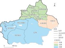
图1
研究区示意图 注:基于新疆标准地图服务网站审图号为新S(2023)061号的标准地图制作,底图边界无修改。昌吉州、伊犁州直、博州、巴州和克州分别为昌吉回族自治州、伊犁哈萨克自治州直属县市、博尔塔拉蒙古自治州、巴音郭楞蒙古自治州、克孜勒苏柯尔克孜自治州的简称。空白区域表示新疆生产建设兵团。下同。"
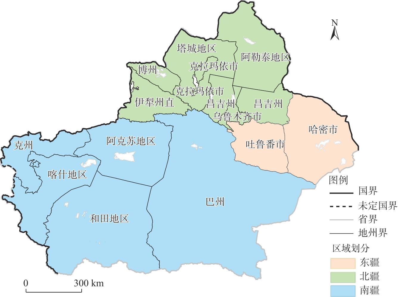
表1
新疆各地州市多维相对贫困指标体系"
| 目标层 | 维度层 | 指标层 | 指标 单位 | 指标 属性 |
|---|---|---|---|---|
| 多维 相对 贫困 指标 体系 | 自然 | 人均农作物播种面积(X1) | hm2·人-1 | 正向 |
| 年均降水量(X2) | mm | 正向 | ||
| 单位面积粮食产量(X3) | kg·hm-2 | 正向 | ||
| 人力 | 平均万人普通中小学在校 生数(X4) | 人·(10人)-4 | 正向 | |
| 平均万人普通中小学教 师数(X5) | 人·(10人)-4 | 正向 | ||
| 乡村劳动力占乡村人口比例(X6) | % | 正向 | ||
| 人均农业机械总动力(X7) | kW·人-1 | 正向 | ||
| 经济 | 人均GDP(X8) | 元 | 正向 | |
| 非私营单位就业人员平均 工资(X9) | 元 | 正向 | ||
| 私营单位就业人员平均工资(X10) | 元 | 正向 | ||
| 人均社会消费品零售总额(X11) | 元 | 正向 | ||
| 城镇居民人均可支配收入(X12) | 元 | 正向 | ||
| 农村居民人均可支配收入(X13) | 元 | 正向 | ||
| 社会 | 平均万人拥有卫生机构数(X14) | 个·(10人)-4 | 正向 | |
| 平均万人拥有卫生机构床位 数(X15) | 张·(10人)-4 | 正向 | ||
| 平均万人拥有卫生技术人员 数(X16) | 人·(10人)-4 | 正向 | ||
| 一般公共预算收支比(X17) | % | 正向 | ||
| 第一产业增加值占比(X18) | % | 负向 |
表2
交互探测器交互作用类型"
| 交互特征 | 交互类型 |
|---|---|
| q(X1∩X2)>q(X1)+q(X2) | 非线性增强 |
| q(X1∩X2)<Min[q(X1), q(X2)] | 非线性减弱 |
| q(X1∩X2)>Max[q(X1), q(X2)] | 双因子增强 |
| Min[q(X1), q(X2)]<q(X1∩X2)<Min[q(X1), q(X2)] | 单因子非线性减弱 |
| q(X1∩X2)=q(X1)+q(X2) | 独立 |
表3
多维相对贫困指标权重赋值结果"
| 维度层 | 指标层 | 2016年 | 2017年 | 2018年 | 2019年 | 2020年 | 2021年 |
|---|---|---|---|---|---|---|---|
| 自然 | X1 | 7.579 | 7.734 | 8.822 | 8.746 | 8.321 | 9.261 |
| X2 | 5.610 | 4.978 | 5.222 | 4.700 | 6.629 | 4.332 | |
| X3 | 5.213 | 5.493 | 2.636 | 6.573 | 7.239 | 7.438 | |
| 人力 | X4 | 7.256 | 6.711 | 6.316 | 7.005 | 8.570 | 8.382 |
| X5 | 3.631 | 3.794 | 4.793 | 3.972 | 3.633 | 4.494 | |
| X6 | 3.309 | 3.072 | 3.412 | 2.574 | 5.730 | 3.896 | |
| X7 | 11.254 | 11.523 | 14.667 | 13.615 | 10.803 | 12.963 | |
| 经济 | X8 | 6.155 | 5.995 | 5.791 | 5.647 | 5.178 | 5.321 |
| X9 | 4.242 | 4.986 | 5.590 | 8.484 | 7.527 | 6.251 | |
| X10 | 4.442 | 5.937 | 6.190 | 3.480 | 3.467 | 2.301 | |
| X11 | 6.184 | 6.263 | 5.858 | 4.853 | 4.623 | 4.750 | |
| X12 | 4.721 | 4.556 | 4.375 | 4.333 | 4.209 | 4.283 | |
| X13 | 4.286 | 4.717 | 4.732 | 4.521 | 4.653 | 5.210 | |
| 社会 | X14 | 2.261 | 2.231 | 2.103 | 2.027 | 2.184 | 3.262 |
| X15 | 7.180 | 4.240 | 3.327 | 5.311 | 3.401 | 5.770 | |
| X16 | 5.832 | 6.112 | 6.321 | 5.049 | 5.326 | 3.239 | |
| X17 | 6.884 | 7.706 | 6.701 | 6.561 | 6.370 | 6.561 | |
| X18 | 3.961 | 3.953 | 3.144 | 2.549 | 2.140 | 2.286 |
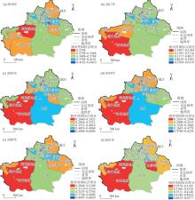
图2
新疆各地州市多维相对贫困指数空间分布"

表4
新疆各地州市相对贫困水平的全局莫兰指数(Moran’s I)"
| 年份 | 全局Moran’s I | Z值 | P值 |
|---|---|---|---|
| 2016 | 0.058476 | 0.561573 | 0.574407 |
| 2017 | 0.228289 | 1.175644 | 0.239737 |
| 2018 | 0.000995 | 0.309823 | 0.756696 |
| 2019 | 0.274568 | -0.856337 | 0.391811 |
| 2020 | 0.015039 | 0.392820 | 0.694452 |
| 2021 | 0.089280 | 1.129658 | 0.258620 |
表5
新疆相对贫困影响因子障碍度排序"
| 地州市 | 障碍度指标排序 | |||||
|---|---|---|---|---|---|---|
| 1 | 2 | 3 | 4 | 5 | 6 | |
| 乌鲁木齐市 | X7(0.193) | X1(0.153) | X4(0.150) | X3(0.096) | X2(0.075) | X5(0.067) |
| 克拉玛依市 | X4(0.242) | X2(0.190) | X15(0.103) | X6(0.086) | X5(0.083) | X14(0.070) |
| 吐鲁番市 | X7(0.141) | X1(0.113) | X3(0.098) | X2(0.090) | X9(0.086) | X4(0.067) |
| 哈密市 | X7(0.141) | X4(0.067) | X1(0.113) | X3(0.098) | X2(0.090) | X17(0.046) |
| 昌吉州 | X7(0.142) | X4(0.134) | X3(0.096) | X1(0.079) | X9(0.072) | X2(0.071) |
| 伊犁州直 | X7(0.163) | X1(0.108) | X9(0.097) | X4(0.078) | X17(0.073) | X8(0.068) |
| 塔城地区 | X7(0.135) | X4(0.125) | X9(0.092) | X17(0.081) | X16(0.064) | X11(0.062) |
| 阿勒泰地区 | X7(0.139) | X9(0.103) | X4(0.092) | X17(0.081) | X6(0.071) | X1(0.066) |
| 博州 | X7(0.146) | X4(0.128) | X17(0.082) | X6(0.080) | X1(0.060) | X2(0.059) |
| 巴州 | X7(0.127) | X9(0.115) | X4(0.097) | X2(0.091) | X1(0.068) | X17(0.068) |
| 阿克苏地区 | X7(0.143) | X9(0.090) | X1(0.079) | X3(0.077) | X2(0.067) | X17(0.067) |
| 克州 | X7(0.145) | X1(0.111) | X3(0.094) | X17(0.085) | X9(0.081) | X6(0.079) |
| 喀什地区 | X7(0.141) | X1(0.100) | X3(0.089) | X17(0.085) | X9(0.069) | X16(0.067) |
| 和田地区 | X7(0.135) | X1(0.102) | X3(0.090) | X9(0.089) | X17(0.079) | X16(0.066) |
图3
相对贫困指标障碍度排前6位的雷达图 注:X1~X18含义如表1所示。"
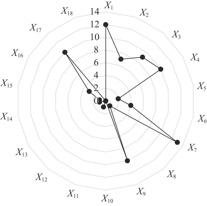
表6
不同因子间交互作用对新疆相对贫困的影响"
| 指标 | X1 | X2 | X3 | X4 | X5 | X6 | X7 | X8 | X9 | X10 | X11 | X12 | X13 | X14 | X15 | X16 | X17 | X18 |
|---|---|---|---|---|---|---|---|---|---|---|---|---|---|---|---|---|---|---|
| X1 | 0.729 | - | - | - | - | - | - | - | - | - | - | - | - | - | - | - | - | - |
| X2 | 0.984 | 0.420 | - | - | - | - | - | - | - | - | - | - | - | - | - | - | - | - |
| X3 | 0.987 | 1.000 | 0.460 | - | - | - | - | - | - | - | - | - | - | - | - | - | - | - |
| X4 | 0.992 | 0.621 | 0.677 | 0.390 | - | - | - | - | - | - | - | - | - | - | - | - | - | - |
| X5 | 0.999 | 0.988 | 0.677 | 0.574 | 0.515 | - | - | - | - | - | - | - | - | - | - | - | - | - |
| X6 | 1.000 | 0.976 | 0.941 | 0.948 | 0.950 | 0.540 | - | - | - | - | - | - | - | - | - | - | - | - |
| X7 | 0.770 | 0.993 | 0.987 | 0.962 | 0.999 | 1.000 | 0.739 | - | - | - | - | - | - | - | - | - | - | - |
| X8 | 0.986 | 0.993 | 0.979 | 0.917 | 0.927 | 0.950 | 0.949 | 0.891 | - | - | - | - | - | - | - | - | - | - |
| X9 | 1.000 | 0.998 | 0.992 | 0.879 | 0.971 | 0.972 | 0.968 | 0.942 | 0.836 | - | - | - | - | - | - | - | - | - |
| X10 | 0.837 | 0.987 | 0.928 | 0.874 | 0.985 | 0.941 | 0.843 | 0.968 | 0.871 | 0.769 | - | - | - | - | - | - | - | - |
| X11 | 0.991 | 0.959 | 0.974 | 0.959 | 0.971 | 0.976 | 0.961 | 0.956 | 0.955 | 0.919 | 0.888 | - | - | - | - | - | - | - |
| X12 | 0.966 | 0.958 | 0.953 | 0.988 | 0.971 | 0.967 | 0.983 | 0.959 | 0.969 | 0.938 | 0.945 | 0.906 | - | - | - | - | - | - |
| X13 | 0.991 | 0.988 | 0.990 | 0.949 | 0.964 | 0.998 | 0.961 | 0.956 | 0.945 | 0.956 | 0.954 | 0.968 | 0.939 | - | - | - | - | - |
| X14 | 0.969 | 0.962 | 0.966 | 0.968 | 0.996 | 0.990 | 0.968 | 0.968 | 0.968 | 0.962 | 0.962 | 0.974 | 0.964 | 0.917 | - | - | - | - |
| X15 | 0.915 | 0.621 | 1.000 | 0.619 | 0.990 | 1.000 | 0.907 | 0.987 | 0.991 | 0.898 | 0.994 | 0.991 | 0.983 | 0.992 | 0.489 | - | - | - |
| X16 | 0.994 | 0.980 | 0.984 | 0.965 | 0.976 | 0.981 | 0.967 | 0.962 | 0.956 | 0.950 | 0.949 | 0.968 | 0.959 | 0.962 | 0.999 | 0.916 | - | - |
| X17 | 0.983 | 0.989 | 0.963 | 0.997 | 0.977 | 0.991 | 0.987 | 0.965 | 0.977 | 0.948 | 0.945 | 0.934 | 0.967 | 0.986 | 0.999 | 0.970 | 0.908 | - |
| X18 | 0.986 | 0.998 | 0.992 | 0.887 | 0.971 | 0.938 | 0.954 | 0.971 | 0.963 | 0.934 | 0.931 | 0.947 | 0.971 | 0.974 | 0.994 | 0.948 | 0.931 | 0.758 |
| [1] | 人民日报. 历史性的跨越, 新奋斗的起点——习近平总书记关于打赢脱贫攻坚战重要论述综述[EB/OL]. [2021-02-24]. https://www.gov.cn/xinwen/2021-02/24/content_5588553.htm. |
| [Pe-ople’s daily. A historic leap, a new starting point for new struggles: A summary of the important statements by the general secretary on winning the poverty alleviation campaign[EB/OL]. [2021-02-24]. https://www.gov.cn/xinwen/2021-02/24/content_5588553.htm.] | |
| [2] | Chong C, Cai M, Yue X M. Focus shift needed: From development-oriented to social security-based poverty alleviation in rural China[J]. Economic and Political Studies, 2022, 10(1): 62-84. |
| [3] | 薛子涵, 温立洲, 李金荣, 等. 河北省农村多维相对贫困的测度、分解与影响因素研究[J]. 统计理论与实践, 2023(10): 30-35. |
| [Xue Zihan, Wen Lizhou, Li Jinrong, et al. Measurement, decomposition and influencing factors of multidimensional relative poverty in rural Hebei Province[J]. Statistical Theory and Practice, 2023(10): 30-35.] | |
| [4] | 王婴, 唐钧. 现代贫困研究: 从绝对到相对再到多维[J]. 河海大学学报(哲学社会科学版), 2020, 22(6): 83-89, 112. |
| [Wang Ying, Tang Jun. Modern poverty research: From absolute to relative to multi-dimensional[J]. Journal of Hohai University (Philosophy and Social Sciences Edition), 2020, 22(6): 83-89, 112.] | |
| [5] | Townsend R M. Optimal contracts and competitive markets with costly state verification[J]. Journal of Economic Theory, 1979, 21(2): 265-293. |
| [6] |
何仁伟, 刘邵权, 陈国阶, 等. 中国农户可持续生计研究进展及趋向[J]. 地理科学进展, 2013, 32(4): 657-670.
doi: 10.11820/dlkxjz.2013.04.018 |
|
[He Renwei, Liu Shaoquan, Chen Guojie, et al. Research progress and tendency of sustainable livelihoods for peasant household in China[J]. Progress in Geography, 2013, 32(4): 657-670.]
doi: 10.11820/dlkxjz.2013.04.018 |
|
| [7] |
袁梦, 谢保鹏, 田丽敏, 等. 六盘山甘肃片区土地利用多功能与多维相对贫困的时空耦合关系[J]. 干旱区地理, 2025, 48(7): 1304-1316.
doi: 10.12118/j.issn.1000-6060.2024.447 |
| [Yuan Meng, Xie Baopeng, Tian Limin, et al. Spatiotemporal coupling relationship between multi-function land use and multi-dimension relative poverty in Liupanshan, Gansu Province[J]. Arid Land Geography, 2025, 48(7): 1304-1316.] | |
| [8] | 张建勋, 夏咏. 深度贫困地区多维贫困测度与时空分异特征——来自新疆南疆四地州的证据[J]. 干旱区资源与环境, 2020, 34(4): 88-93. |
| [Zhang Jianxun, Xia Yong. Multidimensional poverty measurement and spatial-temporal differentiation characteristics in the poverty-stricken areas: Evidence from the four regions in southern Xinjiang[J]. Journal of Arid Land Resources and Environment, 2020, 34(4): 88-93.] | |
| [9] | 汪晓文, 何明辉, 李玉洁. 基于空间贫困视角的扶贫模式再选择——以甘肃为例[J]. 甘肃社会科学, 2012(6): 95-98, 108. |
| [Wang Xiaowen, He Minghui, Li Yujie. Re-choosing poverty alleviation models based on spatial poverty perspective: A case study of Gansu Province[J]. Gansu Social Sciences, 2012(6): 95-98, 108.] | |
| [10] |
金贵, 邓祥征, 董寅, 等. 发展地理学视角下中国多维贫困测度及时空交互特征[J]. 地理学报, 2020, 75(8): 1633-1646.
doi: 10.11821/dlxb202008006 |
| [Jin Gui, Deng Xiangzheng, Dong Yin, et al. China’s multidimensional poverty measurement and its spatiotemporal interaction characteristics in the perspective of development geography[J]. Acta Geographica Sinica, 2020, 75(8): 1633-1646.] | |
| [11] | 王佳珊. 贵州省农村贫困测评及其影响因素分析[D]. 贵阳: 贵州财经大学, 2016. |
| [Wang Jiashan. Rural poverty assessment and analysis of its influencing factors in Guizhou Province[D]. Guiyang: Guizhou University of Finance and Economics, 2016.] | |
| [12] | 杨振, 江琪, 刘会敏, 等. 中国农村居民多维贫困测度与空间格局[J]. 经济地理, 2015, 35(12): 148-153. |
| [Yang Zhen, Jiang Qi, Liu Huimin, et al. Multi-dimensional poverty measure and spatial pattern of China’s rural residents[J]. Economic Geography, 2015, 35(12): 148-153.] | |
| [13] | 陈全功, 程蹊. 空间贫困理论视野下的民族地区扶贫问题[J]. 中南民族大学学报(人文社会科学版), 2011, 31(1): 58-63. |
| [Chen Quangong, Cheng Xi. Poverty in space: Issues of poverty alleviation in ethnic regions from the perspective of spatial poverty theory[J]. Journal of Central South University for Nationalities (Humanities and Social Sciences Edition), 2011, 31(1): 58-63.] | |
| [14] |
陈烨烽, 王艳慧, 赵文吉, 等. 中国贫困村致贫因素分析及贫困类型划分[J]. 地理学报, 2017, 72(10): 1827-1844.
doi: 10.11821/dlxb201710008 |
|
[Chen Yefeng, Wang Yanhui, Zhao Wenji, et al. Contributing factors and classification of poor villages in China[J]. Acta Geographica Sinica, 2017, 72(10): 1827-1844.]
doi: 10.11821/dlxb201710008 |
|
| [15] |
刘艳华, 徐勇. 中国农村多维贫困地理识别及类型划分[J]. 地理学报, 2015, 70(6): 993-1007.
doi: 10.11821/dlxb201506012 |
|
[Liu Yanhua, Xu Yong. Geographical identification and classification of multi-dimensional poverty in rural China[J]. Acta Geographica Sinica, 2015, 70(6): 993-1007.]
doi: 10.11821/dlxb201506012 |
|
| [16] |
周扬, 郭远智, 刘彦随. 中国县域贫困综合测度及2020年后减贫瞄准[J]. 地理学报, 2018, 73(8): 1478-1493.
doi: 10.11821/dlxb201808007 |
|
[Zhou Yang, Guo Yuanzhi, Liu Yansui. Comprehensive measurement of county poverty and anti-poverty targeting after 2020 in China[J]. Acta Geographica Sinica, 2018, 73(8): 1478-1493.]
doi: 10.11821/dlxb201808007 |
|
| [17] | 夏春萍, 雷欣悦, 王翠翠. 我国农村多维贫困的空间分布特征及影响因素分析——基于31省的多维贫困测度[J]. 中国农业大学学报, 2019, 24(8): 229-238. |
| [Xia Chunping, Lei Xinyue, Wang Cuicui. Analysis of the spatial distribution characteristics and influencing factors of multidimensional poverty in rural China: Based on a multidimensional poverty measurement of 31 provinces[J]. Journal of China Agricultural University, 2019, 24(8): 229-238.] | |
| [18] | 马文利. 国内外贫困研究热点及前沿动态分析——基于CiteSpace的文献计量[J]. 新疆财经大学学报, 2020(2): 5-15. |
| [Ma Wenli. An analysis of hotspots and frontiers of poverty studies in china and foreign countries: Bibliometrics based on CiteSpace[J]. Journal of Xinjiang University of Finance and Economics, 2020(2): 5-15.] | |
| [19] | 樊增增, 邹薇. 从脱贫攻坚走向共同富裕: 中国相对贫困的动态识别与贫困变化的量化分解[J]. 中国工业经济, 2021(10): 59-77. |
| [Fan Zengzeng, Zou Wei. From anti-poverty campaign to common prosperity: Dynamic identification of relative poverty and quantitative decomposition of poverty changes in China[J]. China Industrial Economics, 2021(10): 59-77.] | |
| [20] | 苏芳, 常江波, 范冰洁, 等. 多维视角下相对贫困治理的中国探索[J]. 中国软科学, 2023(11): 66-73. |
| [Su Fang, Chang Jiangbo, Fan Bingjie, et al. Exploration of relative poverty governance in China from a multidimensional perspective[J]. China Soft Science, 2023(11): 66-73.] | |
| [21] | 高杰. 新疆南疆农村少数民族家庭相对贫困的长效治理路径研究[D]. 阿拉尔: 塔里木大学, 2023. |
| [Gao Jie. Research on the long-term governance path of relative poverty among ethnic minority families in southern Xinjiang[D]. Aral: Tarim University, 2023.] | |
| [22] | 王小林, 冯贺霞. 2020年后中国多维相对贫困标准: 国际经验与政策取向[J]. 中国农村经济, 2020(3): 2-21. |
| [Wang Xiaolin, Feng Hexia. China’s multidimensional relative poverty standards in the post-2020 era: International experience and policy orientation[J]. Chinese Rural Economy, 2020(3): 2-21.] | |
| [23] | 侯守杰. 后小康时代的相对贫困治理[J]. 西北农林科技大学学报(社会科学版), 2021, 21(2): 36-42. |
| [Hou Shoujie. Relative poverty control in the post-well-off era[J]. Journal of Northwest A & F University (Social Science Edition), 2021, 21(2): 36-42.] | |
| [24] |
刘新梅, 韩林芝, 郑江华, 等. 贫困县多维综合贫困度时空分异特征及其驱动机制——以南疆四地州深度贫困地区贫困县为例[J]. 经济地理, 2019, 39(7): 165-174.
doi: 10.15957/j.cnki.jjdl.2019.07.019 |
|
[Liu Xinmei, Han Linzhi, Zheng Jianghua, et al. Temporal-spatial characteristics and the driving mechanism of multidimensional comprehensive poverty degree in poverty-stricken counties: A case study of poor counties in deep poverty-stricken areas of southern Xinjiang[J]. Economic Geography, 2019, 39(7): 165-174.]
doi: 10.15957/j.cnki.jjdl.2019.07.019 |
|
| [25] | 郭显光. 熵值法及其在综合评价中的应用[J]. 财贸研究, 1994(6): 56-60. |
| [Guo Xianguang. Entropy value method and its application in comprehensive evaluation[J]. Finance and Trade Research, 1994(6): 56-60.] | |
| [26] | 苟廷佳, 陆威文. 基于组合赋权TOPSIS模型的生态文明建设评价——以青海省为例[J]. 统计与决策, 2020, 36(24): 57-60. |
| [Gou Tingjia, Lu Weiwen. Evaluation of ecological civilization construction based on combination weighted TOPSIS model: Taking Qinghai Province as an example[J]. Statistics & Decision, 2020, 36(24): 57-60.] | |
| [27] | 许月卿, 李双成, 蔡运龙. 基于GIS和人工神经网络的区域贫困化空间模拟分析——以贵州省猫跳河流域为例[J]. 地理科学进展, 2006, 25(3): 79-85, 140. |
| [Xu Yueqing, Li Shuangcheng, Cai Yunlong. Spatial simulation using GIS and artificial neural network for regional poverty: A case study of Maotiaohe Watershed, Guizhou Province[J]. Progress in Geography, 2006, 25(3): 79-85, 140.] | |
| [28] | 王成武, 黄佳. 基于TOPSIS模型的凉山州空间贫困特征及障碍因素分析[J]. 时空信息学报, 2020, 27(2): 87-93. |
| [Wang Chengwu, Huang Jia. On the spatial distribution and influencing factors of poverty in Liangshan Prefecture using TOPSIS model[J]. Journal of Spatio-temporal Information, 2020, 27(2): 87-93.] | |
| [29] | 尹晓翠, 许洋, 张艺琳, 等. 基于熵权TOPSIS法的青岛市农业高质量发展评价及障碍度分析[J]. 青岛农业大学学报(自然科学版), 2023, 40(4): 304-307, 311. |
| [Yin Xiaocui, Xu Yang, Zhang Yilin, et al. Evaluation and obstacle degree analysis for high-quality development of agriculture in Qingdao based on entropy weight TOPSIS method[J]. Journal of Qingdao Agricultural University (Natural Science Edition), 2023, 40(4): 304-307, 311.] | |
| [30] | 李东, 由亚男, 马长发, 等. 干旱区绿洲城镇空间贫困分异特征及其影响因素分析——以新疆南疆三地州为例[J]. 世界地理研究, 2018, 27(3): 86-98. |
| [Li Dong, You Yanan, Ma Changfa, et al. Analysis on the differentiation characteristics of spatial poverty and its influencing factors in the oasis towns of arid areas: Taking three south Xinjiang districts as an example[J]. World Regional Studies, 2018, 27(3): 86-98.] | |
| [31] |
王劲峰, 徐成东. 地理探测器: 原理与展望[J]. 地理学报, 2017, 72(1): 116-134.
doi: 10.11821/dlxb201701010 |
|
[Wang Jinfeng, Xu Chengdong. Geodetector: Principle and prospective[J]. Acta Geographica Sinica, 2017, 72(1): 116-134.]
doi: 10.11821/dlxb201701010 |
|
| [32] |
郭佳丽, 杜宏茹. 多元流视角下新疆绿洲城市网络格局研究[J]. 干旱区地理, 2025, 48(2): 323-332.
doi: 10.12118/j.issn.1000-6060.2024.158 |
|
[Guo Jiali, Du Hongru. Network pattern of oasis cities in Xinjiang from the perspective of multiple flows[J]. Arid Land Geography, 2025, 48(2): 323-332.]
doi: 10.12118/j.issn.1000-6060.2024.158 |
|
| [33] | 聂蕊, 刘伟, 刘思文. 南疆四地州相对贫困的多维识别与协同治理[J]. 河北农业大学学报(社会科学版), 2022, 24(5): 115-124. |
| [Nie Rui, Liu Wei, Liu Siwen. Multi-dimensional identification and collaborative governance of relative poverty in four prefectures in southern Xinjiang[J]. Journal of Hebei Agricultural University (Social Sciences Edition), 2022, 24(5): 115-124.] | |
| [34] | 蔡兴冉, 梁彦庆, 黄志英, 等. 河北省县域相对贫困度空间分异及影响因素分析[J]. 西南大学学报(自然科学版), 2019, 41(10): 62-71. |
| [Cai Xingran, Liang Yanqing, Huang Zhiying, et al. Analysis of relative poverty degree of the counties of Hebei Province and its influencing factors[J]. Journal of Southwest University (Natural Science Edition), 2019, 41(10): 62-71.] |
| [1] | 李亮亮, 夏咏, 王福红, 郭冰心, 赵兰兰. 新疆甜瓜生产格局及其贡献因素分析[J]. 干旱区地理, 2025, 48(9): 1567-1577. |
| [2] | 石卓达, 杨宏伟. 旅游经济高质量发展测度及影响因素分析——以新疆为例[J]. 干旱区地理, 2025, 48(7): 1233-1242. |
| [3] | 袁梦, 谢保鹏, 田丽敏, 陈英, 裴婷婷. 六盘山甘肃片区土地利用多功能与多维相对贫困的时空耦合关系[J]. 干旱区地理, 2025, 48(7): 1304-1316. |
| [4] | 苗颖凤, 原野, 周正伟, 赵嘉瑜, 郭宇茜. 汾渭平原农作物种植结构时空格局演变特征研究[J]. 干旱区地理, 2025, 48(6): 995-1005. |
| [5] | 刘海军, 张海虹, 闫俊杰, 李想, 李高峰. 新疆农业碳排放效率时空异质性及其影响因素[J]. 干旱区地理, 2025, 48(5): 866-878. |
| [6] | 李松芮, 林秋平, 杨上广. 新疆物流企业空间布局多尺度演化特征及影响因素研究[J]. 干旱区地理, 2025, 48(4): 739-752. |
| [7] | 王福红, 夏咏. 干旱区主要农作物生产时空格局演化及影响因素分析——以新疆地区为例[J]. 干旱区地理, 2025, 48(3): 444-454. |
| [8] | 李梦园, 庞家朋, 李欢. 省域典型旅游集散地综合可达性协调发展及空间关系研究——以新疆为例[J]. 干旱区地理, 2025, 48(3): 539-548. |
| [9] | 贾妮娅·叶力肯, 侯建楠, 刘思博. 近30 a新疆地州市旅游气候舒适度时空特征分析[J]. 干旱区地理, 2025, 48(2): 212-222. |
| [10] | 郭佳丽, 杜宏茹. 多元流视角下新疆绿洲城市网络格局研究[J]. 干旱区地理, 2025, 48(2): 323-332. |
| [11] | 李刚. 高质量发展的新疆实践:评估体系构建及测度研究[J]. 干旱区地理, 2025, 48(1): 143-152. |
| [12] | 刘慧, 孙思奥, 方创琳, 周迪, 鲍超. 1990—2020年新疆用水量时空演化格局及影响因素分析[J]. 干旱区地理, 2024, 47(9): 1451-1461. |
| [13] | 石玉东, 王圣杰, 张明军, 朱成刚, 车彦军. 昆仑山北坡地表水氢氧稳定同位素空间分布特征[J]. 干旱区地理, 2024, 47(7): 1127-1135. |
| [14] | 夏文浩, 霍瑜, 逯渊, 王超毅. 新疆农业碳排放的时空差异与空间溢出效应分析[J]. 干旱区地理, 2024, 47(6): 1084-1096. |
| [15] | 樊静, 申彦波, 常蕊. 气候变化对太阳能资源评估典型气象年选取的影响[J]. 干旱区地理, 2024, 47(6): 922-931. |
|
||