| [1] |
田亚林, 李雪梅, 李珍, 等. 1980—2017年天山山区不同降水形态的时空变化[J]. 干旱区地理, 2020, 43(2): 308-318.
|
|
[Tian Yalin, Li Xuemei, Li Zhen, et al. Spatial and temporal variations of different precipitation types in the Tianshan Mountains from 1980 to 2017[J]. Arid Land Geography, 2020, 43(2): 308-318.]
|
| [2] |
刘梅, 俞剑蔚, 蒋义芳, 等. 2020年3月28日沿江和苏南突发降雪多源监测特征及成因分析[J]. 气象, 2021, 47(10): 1169-1181.
|
|
[Liu Mei, Yu Jianwei, Jiang Yifang, et al. Multi-source monitoring characteristics and causes of abrupt snowfall in southern Jiangsu on 28 March 2020[J]. Meteorological Monthly, 2021, 47(10): 1169-1181.]
|
| [3] |
孙继松, 梁丰, 陈敏, 等. 北京地区一次小雪天气过程造成路面交通严重受阻的成因分析[J]. 大气科学, 2003, 27(6): 1057-1066.
|
|
[Sun Jisong, Liang Feng, Chen Min, et al. An analysis on serious city traffic trouble caused by light snow[J]. Chinese Journal of Atmospheric Sciences, 2003, 27(6): 1057-1066.]
|
| [4] |
龙柯吉, 王佳津, 郭旭, 等. 四川省降水相态识别判据研究[J]. 高原山地气象研究, 2016, 36(3): 57-65.
|
|
[Long Keji, Wang Jiajin, Guo Xu, et al. Research on discrimination criterion of precipitation types in Sichuan Province[J]. Plateau and Mountain Meteorology Research, 2016, 36(3): 57-65.]
|
| [5] |
Pierre B. A method to determine precipitation types[J]. Weather and Forecasting, 2000, 15(5): 583-592.
doi: 10.1175/1520-0434(2000)015<0583:AMTDPT>2.0.CO;2
|
| [6] |
Heppner, Paul O G. Snow versus rain: Looking beyond the “Magic” numbers[J]. Weather and Forecasting, 1992, 7(4): 683-691.
doi: 10.1175/1520-0434(1992)007<0683:SVRLBT>2.0.CO;2
|
| [7] |
Czys R R, Scott R W, Tang K C. A physically based, nondimensional parameter for discriminating between locations of freezing rain and ice pellets[J]. Weather and Forecasting, 1996, 11(4): 591-598.
doi: 10.1175/1520-0434(1996)011<0591:APBNPF>2.0.CO;2
|
| [8] |
李江波, 李根娥, 裴雨杰, 等. 一次春季强寒潮的降水相态变化分析[J]. 气象, 2009, 35(7): 87-94.
|
|
[Li Jiangbo, Li Gen’e, Pei Yujie, et al. Analysis on the phase transformation of precipitation during a strong cold wave happened in spring[J]. Meteorological Monthly, 2009, 35(7): 87-94.]
|
| [9] |
高松影, 李慧琳, 宋丽丽, 等. 丹东冬季降水相态判据研究[J]. 气象与环境学报, 2014, 30(2): 38-44.
|
|
[Gao Songying, Li Huilin, Song Lili, et al. Study on criteria for winter precipitation phase states in Dandong[J]. Journal of Meteorology Environment, 2014, 30(2): 38-44.]
|
| [10] |
漆梁波, 张瑛. 中国东部地区冬季降水相态的识别判据研究[J]. 气象, 2012, 38(1): 96-102.
|
|
[Qi Liangbo, Zhang Ying. Research on winter precipitation types discrimination criterion in eastern China[J]. Meteorological Monthly, 2012, 38(1): 96-102.]
|
| [11] |
王洪霞, 苗爱梅, 董春卿, 等. 山西一次春季降水过程相态变化的成因分析[J]. 高原气象, 2013, 32(6): 1787-1794.
doi: 10.7522/j.issn.1000-0534.2012.00165
|
|
[Wang Hongxia, Miao Aimei, Dong Chunqing, et al. Cause analysis on the phase transformation of precipitation in Shanxi in spring[J]. Plateau Meteorology, 2013, 32(6): 1787-1794.]
doi: 10.7522/j.issn.1000-0534.2012.00165
|
| [12] |
高婧, 杨涛, 李海燕, 等. 近60 a新疆塔城地区不同相态降水时空变化特征[J]. 干旱区地理, 2022, 45(5): 1347-1356.
|
|
[Gao Jing, Yang Tao, Li Haiyan, et al. Temporal and spatial variation of different precipitation types in Tacheng area of Xinjiang in recent 60 years[J]. Arid Land Geography, 2022, 45(5): 1347-1356.]
|
| [13] |
张琳娜, 郭锐, 曾剑, 等. 北京地区冬季降水相态的识别判据研究[J]. 高原气象, 2013, 32(6): 1780-1786.
doi: 10.7522/j.issn.1000-0534.2012.00147
|
|
[Zhang Linna, Guo Rui, Zeng Jian, et al. Research on winter precipitation types discrimination criterion in Beijing[J]. Plateau Meteorology, 2013, 32(6): 1780-1786.]
doi: 10.7522/j.issn.1000-0534.2012.00147
|
| [14] |
许美玲, 梁红丽, 金少华, 等. 昆明冬季降水相态识别判据研究[J]. 气象, 2015, 41(4): 474-479.
|
|
[Xu Meiling, Liang Hongli, Jin Shaohua, et al. Study on identification criterion for precipitation phase in winter Kunming[J]. Meteorological Monthly, 2015, 41(4): 474-479.]
|
| [15] |
张志杰, 王志楠. 呼和浩特市降水相态识别判据研究[J]. 内蒙古林业科技, 2017, 43(1): 42-47.
|
|
[Zhang Zhijie, Wang Zhinan. Research on identification criterion of precipitation phase in Hohhot[J]. Journal of Inner Mongolia Forestry Science and Technology, 2017, 43(1): 42-47.]
|
| [16] |
段云霞, 李得勤, 李大为, 等. 沈阳降水相态特征分析及预报方法[J]. 干旱气象, 2016, 34(1): 51-57.
doi: 10.11755/j.issn.1006-7639(2016)-01-0051P457
|
|
[Duan Yunxia, Li Deqin, Li Dawei, et al. Analysis on precipitation phase characteristics and its forecast methods of Shenyang[J]. Journal of Arid Meteorology, 2016, 34(1): 51-57.]
doi: 10.11755/j.issn.1006-7639(2016)-01-0051P457
|
| [17] |
张俊兰, 彭军. 北疆春季降水相态转换判识和成因分析[J]. 高原气象, 2017, 36(4): 939-949.
doi: 10.7522/j.issn.1000-0534.2016.00094
|
|
[Zhang Junlan, Peng Jun. A forecast analysis of precipitation phase transformation and rainfall intensity in spring over northern Xinjiang[J]. Plateau Meteorology, 2017, 36(4): 939-949.]
doi: 10.7522/j.issn.1000-0534.2016.00094
|
| [18] |
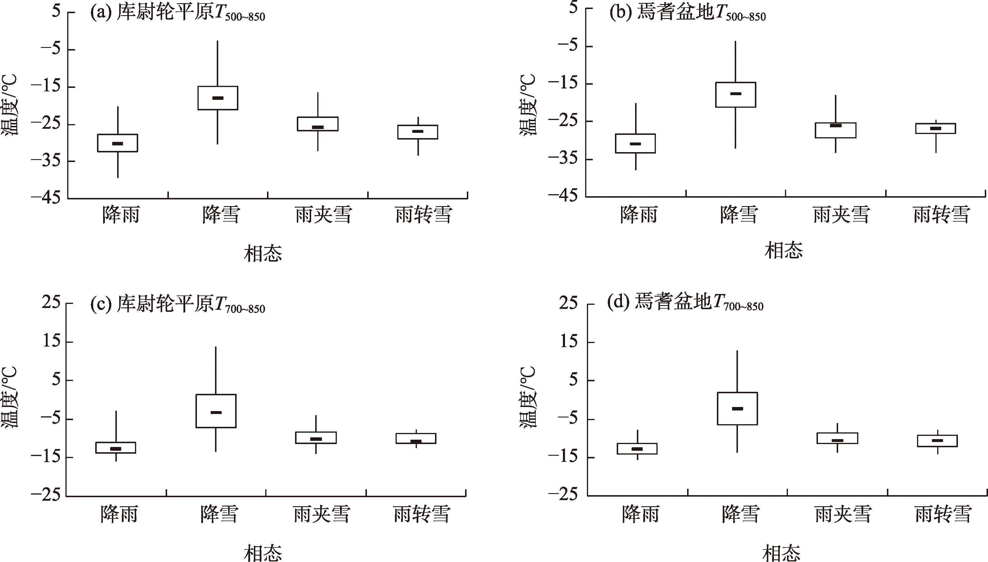
杨贵名, 宗志平, 马学款. “方框-端须图”及其应用示例[J]. 气象, 2005, 31(3): 53-55.
|
|
[Yang Guiming, Zong Zhiping, Ma Xuekuan. “Box-whiskey”and its application examples[J]. Meteorology Monthly, 2005, 31(3): 53-55.]
|
| [19] |
王焕毅, 张翘, 効碧鸿, 等. 本溪冬半年降水相态的识别判据研究[J]. 中国农学通报, 2015, 31(22): 243-247.
doi: 10.11924/j.issn.1000-6850.casb15020104
|
|
[Wang Huanyi, Zhang Qiao, Xiao Bihong, et al. Study on identification criterion of precipitation phase in winter-half-year in Benxi[J]. Chinese Agricultural Science Bulletin, 2015, 31(22): 243-247.]
doi: 10.11924/j.issn.1000-6850.casb15020104
|
| [20] |
戴东新. 暴雪[M]. 上海: 上海科学技术文献出版社, 2014: 94-95.
|
|
[Dai Dongxin. Blizzard[M]. Shanghai: Shanghai Scientific and Technological Literature Press, 2014: 94-95.]
|
| [21] |
杨成芳, 姜鹏, 张少林, 等. 山东冬半年降水相态的温度特征统计分析[J]. 气象, 2013, 39(3): 355-361.
|
|
[Yang Chengfang, Jiang Peng, Zhang Shaolin, et al. Analysis on temperature of precipitation types in cold seasons in Shandong[J]. Meteorology Monthly, 2013, 39(3): 355-361.]
|
| [22] |
孙燕, 严文莲, 尹东屏, 等. 江苏冬季降水相态气候分布特征及预报方法探讨[J]. 气象科学, 2013, 33(3): 325-332.
|
|
[Sun Yan, Yan Wenlian, Yin Dongping, et al. Climatic characteristics and forecast of precipitation phase in winter of Jiangsu[J]. Journal of the Meteorological Sciences, 2013, 33(3): 325-332.]
|
| [23] |
李延香. 1993年LAFS数值降水预报产品评价[J]. 应用气象学报, 1995, 6(3): 281-288.
|
|
[Li Yanxiang. Verification of precipitation forecasts for 1993 from limited-area analysis forecast system[J]. Journal of Applied Meteorological Science, 1995, 6(3): 281-288.]
|
| [24] |
隋玉秀, 杨景泰, 王建, 等. 大连地区冬季降水相态的预报方法初探[J]. 气象, 2015, 41(4): 464-473.
|
|
[Sui Yuxiu, Yang Jingtai, Wang Jian, et al. Preliminary study about the forecasting of winter precipitation types in Dalian[J]. Meteorology Monthly, 2015, 41(4): 464-473.]
|
| [25] |
任兆鹏, 张苏平, 马艳, 等. 青岛冬半年降水相态统计分析及判别方法研究[J]. 海洋气象学报, 2018, 38(1): 27-33.
|
|
[Ren Zhaopeng, Zhang Suping, Ma Yan, et al. Statistical analysis and discrimination criterion on precipitation types of winter half year in Qingdao[J]. Journal of Marine Meteorology, 2018, 38(1): 27-33.]
|
| [26] |
张丽, 徐朋飞, 吴胜平, 等. 安庆市降水相态识别判据研究[J]. 气象与环境学报, 2018, 34(1): 30-37.
|
|
[Zhang Li, Xu Pengfei, Wu Shengping, et al. Analysis of identification criterion of precipitation phase in Anqing City[J]. Journal of Meteorology and Environment, 2018, 34(1): 30-37.]
|
 ),万瑜2,张仕明1(