Arid Land Geography ›› 2026, Vol. 49 ›› Issue (7): 1418-1429.doi: 10.12118/j.issn.1000-6060.2025.395
• Land Use and Ecosystem • Previous Articles Next Articles
LI Lingling1( ), REN Jun1,2,3, LI Chengying1(), WANG Shuqi1, CHEN Rui1, WEN Shuo1
Received:2025-07-09
Revised:2025-09-01
Online:2026-07-25
Published:2026-07-07
Contact:
LI Chengying
E-mail:lilingling@qhu.edu.cn;lichengying@qhu.edu.cn
LI Lingling, REN Jun, LI Chengying, WANG Shuqi, CHEN Rui, WEN Shuo. Spatiotemporal differentiation characteristics and driving factors of sustainable utilization of natural capital in the Qinghai-Xizang alpine region: A case of Qinghai Province[J].Arid Land Geography, 2026, 49(7): 1418-1429.
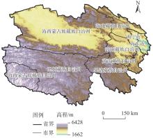
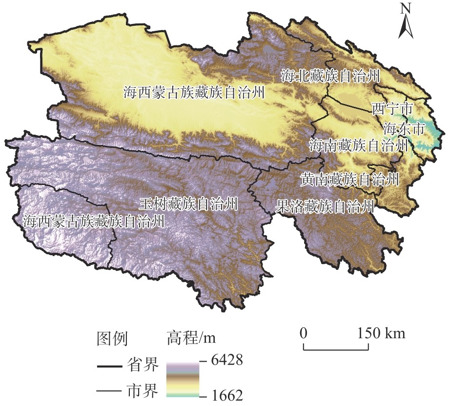
Fig. 1
Schematic diagram of the study area"

Tab. 1
Classification of consumption items"
| 足迹类别 | 土地类型 | 消费项目 | 均衡因子 | 产量因子 |
|---|---|---|---|---|
| 生物资源 | 耕地 | 小麦、杂粮、蚕豆、豌豆、薯类、油菜籽、烟叶、蔬菜和食用菌、瓜果、甜菜、枸杞、猪肉 | 4.3805 | 0.7442 |
| 林地 | 苹果、梨、葡萄、蜂蜜、木材 | 0.1676 | 0.0801 | |
| 草地 | 牛肉、羊肉、其他、牛奶、羊毛 | 0.0722 | 0.2382 | |
| 水域(湖泊、河流积雪和冰川) | 水产品 | 0.0475 | 4.2342 | |
| 能源资源 | 建设用地 | 一次电力、原煤、天然气、石油 | 4.3805 | 0.7442 |
Tab. 2
Grades of ecological sustainable development levels"
| 生态可持续发展指数(ESI) | ESI<0.20 | 0.20≤ESI<0.35 | 0.35≤ESI<0.50 | 0.50≤ESI<0.65 | 0.65≤ESI<0.80 | 0.80≤ESI<1.00 |
|---|---|---|---|---|---|---|
| 生态可持续发展程度 | 严重不可持续 | 中等不可持续 | 轻度不可持续 | 轻度可持续 | 中等可持续 | 强可持续 |
Tab. 3
Index system of driving factors for the sustainable utilization of natural capital in Qinghai Province"
| 类型 | 解释变量 | 方差膨胀因子 |
|---|---|---|
| 经济发展 | 地区生产总值/108元 | 30.691 |
| 第二产业增加值占地区生产总值的比重/% | 8.087 | |
| 第三产业增加值占地区生产总值的比重/% | 7.263 | |
| 固定资产投资增速/% | 1.393 | |
| 社会发展 | 城镇居民可支配收入/元 | 20.226 |
| 城镇居民人均消费生活支出/元·人-1 | 10.855 | |
| 农村居民可支配收入/元 | 35.334 | |
| 农村居民人均消费生活支出/元·人-1 | 22.464 | |
| 科技进步 | 互联网宽带接入用户数/户 | 42.156 |
| 科学研究从业人员数量/人 | 5.720 | |
| 能源强度 | 农村用电量/104 kWh | 12.224 |
| 发电量/108 kWh | 1.701 | |
| 化肥施用量/t | 5.853 |
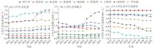
Fig. 2
Trends of per capita ecological footprint, per capita ecological carrying capacity, and per capita ecological deficit/surplus of Qinghai Province from 2012 to 2022"
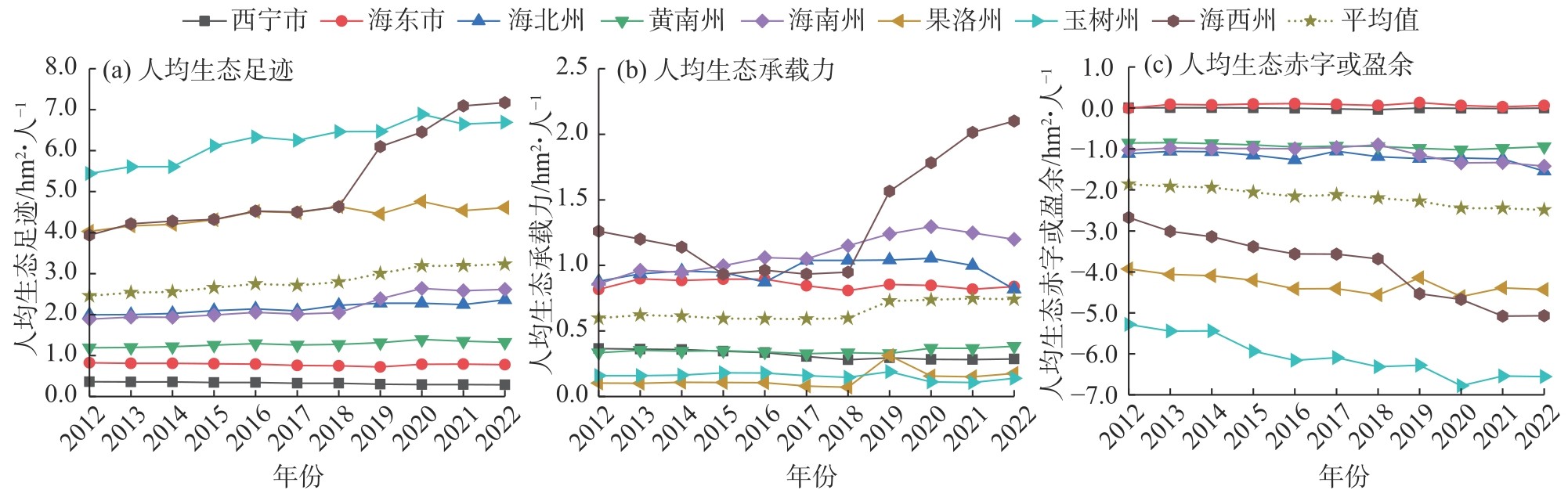
Fig. 3
Transfer trajectory of the per capita three-dimensional ecological footprint centroid of Qinghai Province from 2012 to 2022"
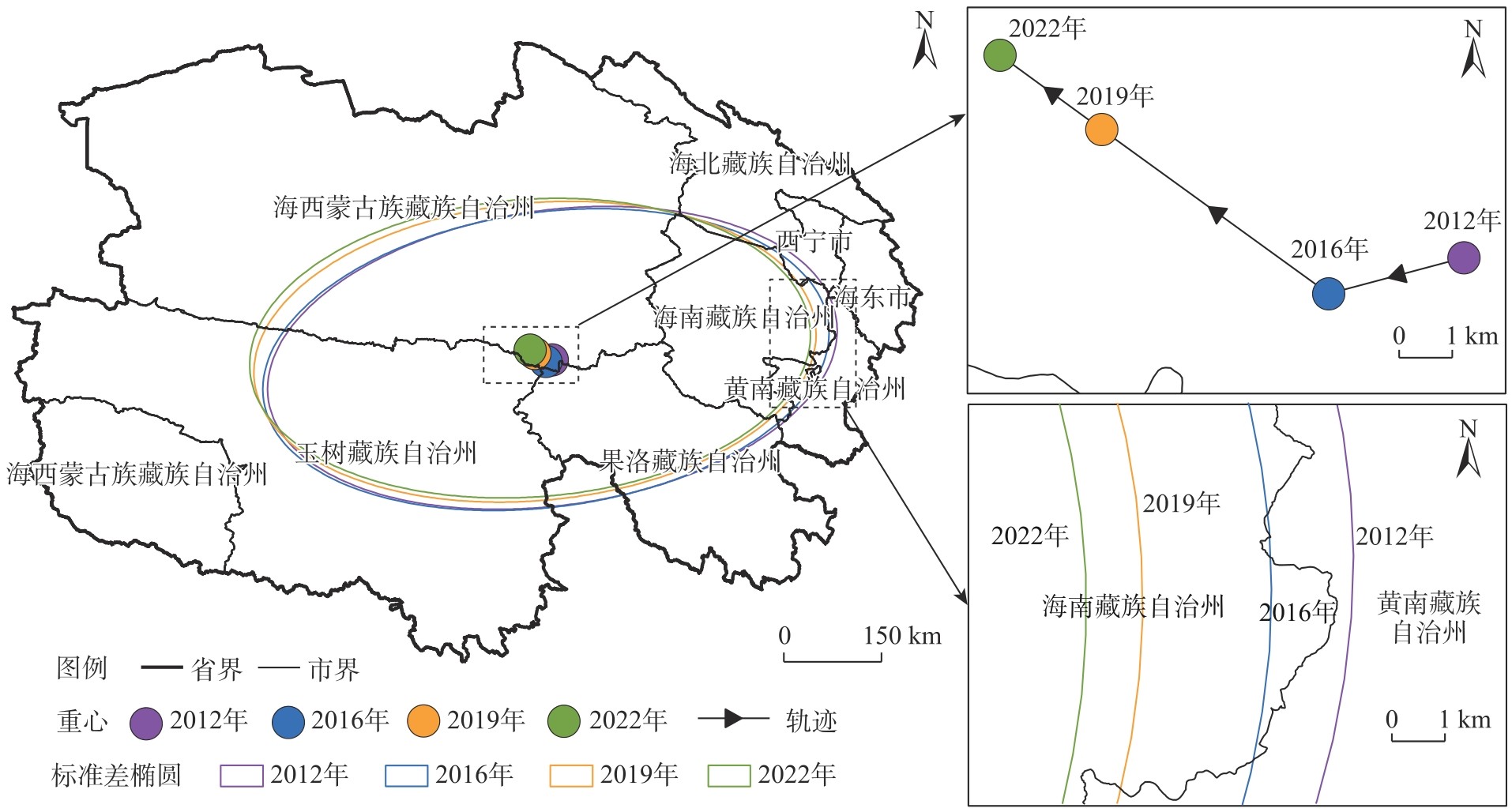
Fig. 4
Land type composition of ecological carrying capacity of Qinghai Province from 2012 to 2022"
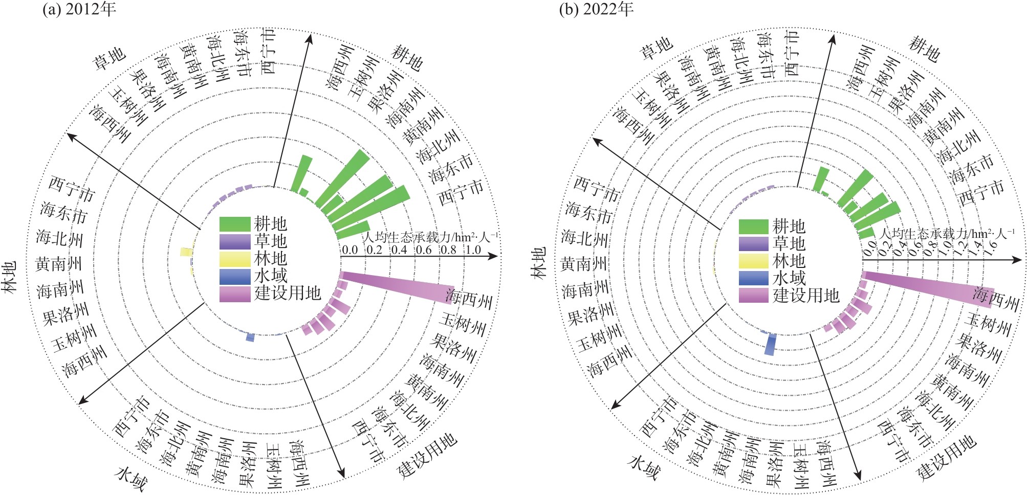
Fig. 5
Footprint breadth and depth of Qinghai Province from 2012 to 2022"
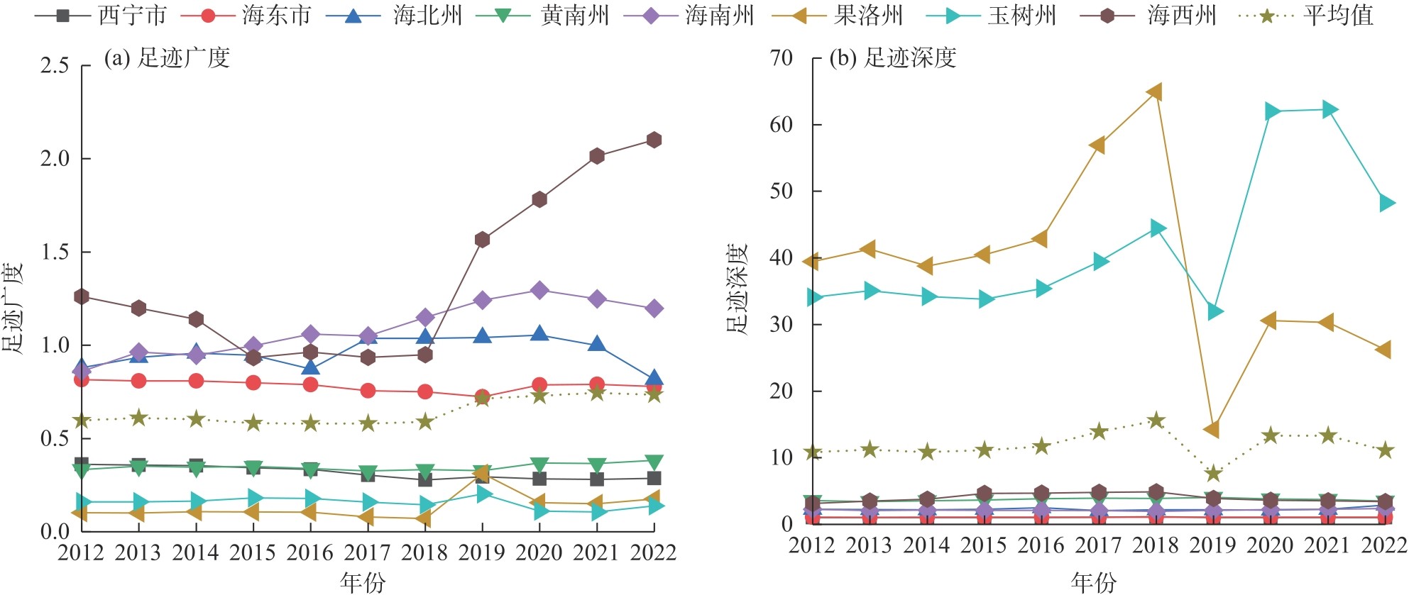
Fig. 6
Occupancy rates of capital flow of each land type and the utilization ratios of stock to flow of Qinghai Province in 2012 and 2022"
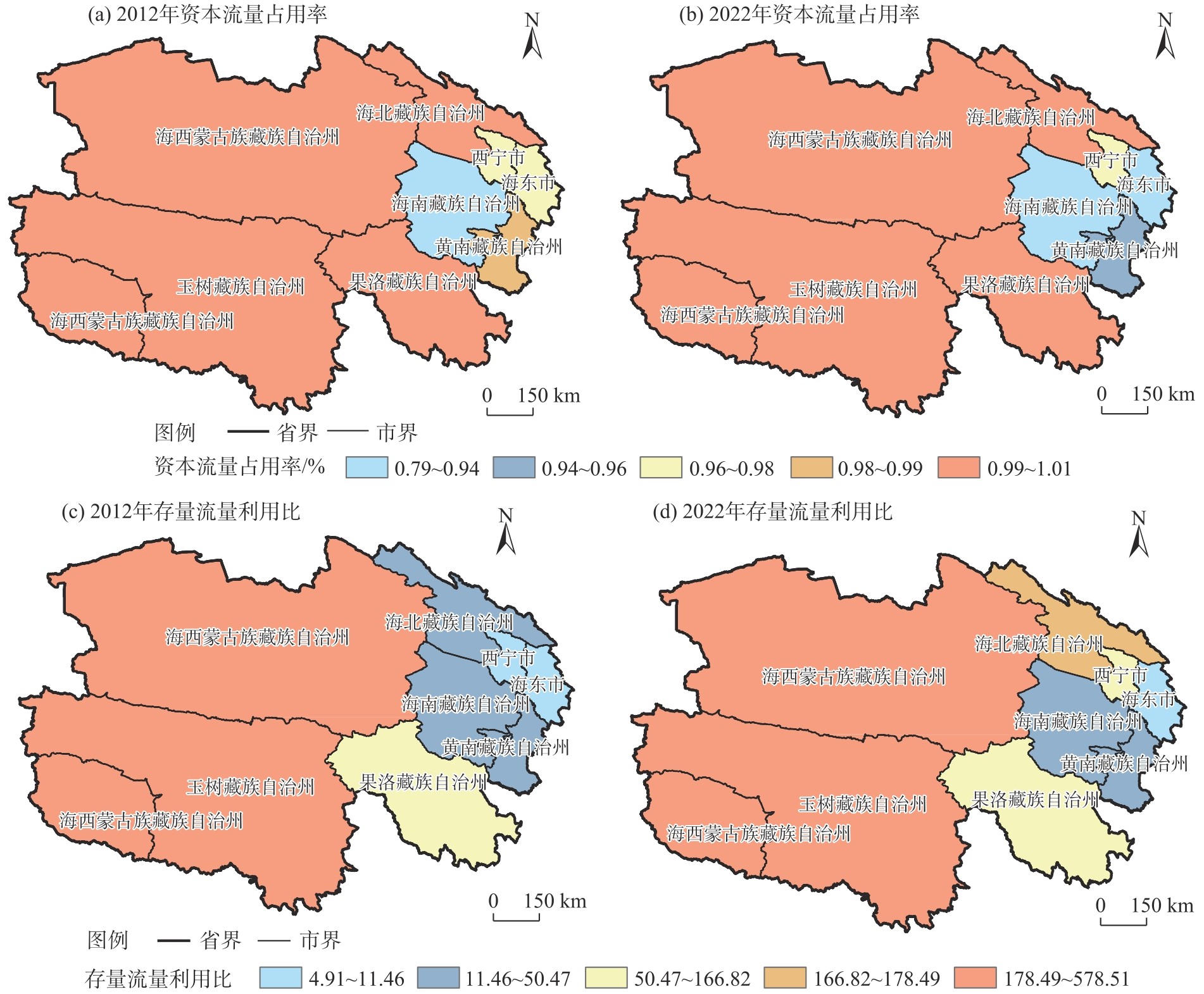
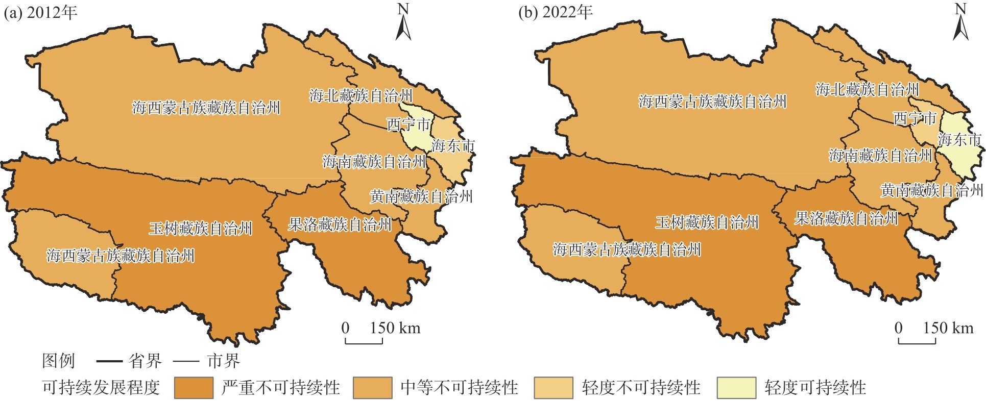
Fig. 7
Spatial pattern of the sustainable development level of Qinghai Province in 2012 and 2022"
Tab. 4
Results of linear regression"
| 自变量 | 系数估计 | 标准差 | t值 | P值 |
|---|---|---|---|---|
| 常数项 | 7.715 | 1.001 | 7.703 | 0.000 |
| 第二产业增加值占地区生产总值的比重 | -0.003 | 0.013 | -0.250 | 0.803 |
| 第三产业增加值占地区生产总值的比重 | -0.093 | 0.018 | -5.233 | 0.000 |
| 固定资产投资增速 | -0.011 | 0.007 | -1.663 | 0.100 |
| 科学研究从业人员数量 | 0.000 | 0.000 | 0.868 | 0.388 |
| 发电量 | -0.003 | 0.002 | -1.824 | 0.072 |
| 化肥施用量 | 0.000 | 0.000 | -5.178 | 0.000 |
Tab. 5
Model validation results"
| 模型参数 | OLS | GWR | GTWR |
|---|---|---|---|
| R2 | 0.5263 | 0.9957 | 0.9965 |
| AICc | 197.9 | 137.7 | 57.7 |
| 模型特征 | 无时间、无空间 | 有空间、无时间 | 有时间、有空间 |
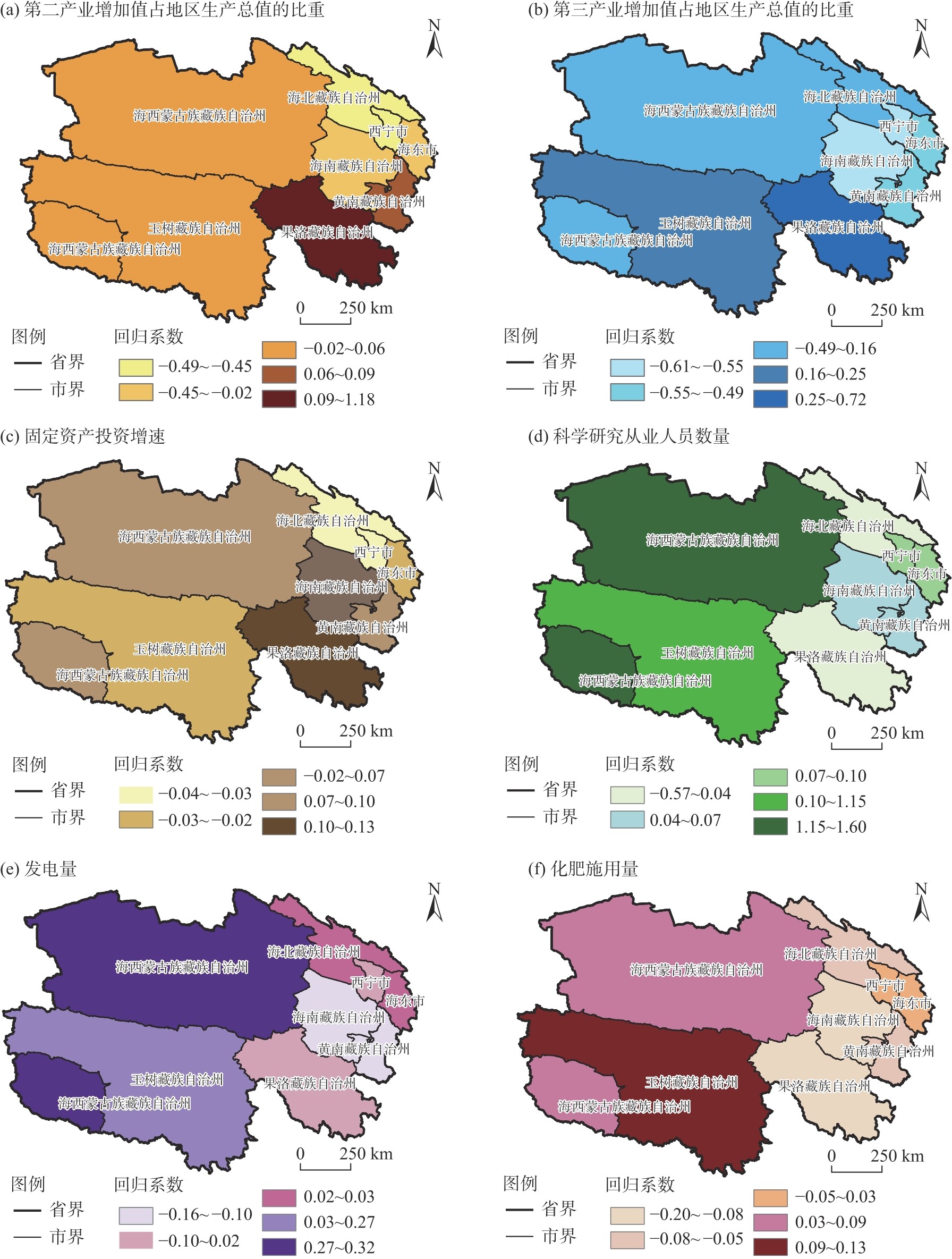
Fig. 8
Spatial distributions of influencing factors on sustainable utilization of natural capital based on GTWR model"
| [1] | 董建红, 张志斌, 张文斌. 基于三维生态足迹的甘肃省自然资本利用动态变化及驱动力[J]. 生态学杂志, 2019, 38(10): 3075-3085. |
| [Dong Jianhong, Zhang Zhibin, Zhang Wenbin. Dynamic changes and driving forces of natural capital utilization in Gansu Province based on the three-dimensional ecological footprint[J]. Chinese Journal of Ecology, 2019, 38(10): 3075-3085.] | |
| [2] | 张军泽, 王帅, 赵文武, 等. 可持续发展目标关系研究进展[J]. 生态学报, 2019, 39(22): 8327-8337. |
| [Zhang Junze, Wang Shuai, Zhao Wenwu, et al. Research progress on the relationships among sustainable development goals[J]. Acta Ecological Sinica, 2019, 39(22): 8327-8337.] | |
| [3] |
Farley J, Daly H. Natural capital: The limiting factor a reply to Aronson, Blignaut, Milton and Clewell[J]. Ecological Engineering, 2006, 28(1): 6-10.
doi: 10.1016/j.ecoleng.2006.05.021 |
| [4] |
Turner K R, Daily C G. The ecosystem services framework and natural capital conservation[J]. Environmental and Resource Economics, 2008, 39(1): 25-35.
doi: 10.1007/s10640-007-9176-6 |
| [5] | 张彩平, 姜紫薇, 韩宝龙, 等. 自然资本价值核算研究综述[J]. 生态学报, 2021, 41(23): 9174-9185. |
| [Zhang Caiping, Jiang Ziwei, Han Baolong, et al. A review of research on natural capital valuation[J]. Acta Ecological Sinica, 2021, 41(23): 9174-9185.] | |
| [6] | 刘洋, 王爱国. 自然资本核算研究的理论与方法综述[J]. 会计之友, 2019(3): 26-31. |
| [Liu Yang, Wang Aiguo. A review of the theories and methods of natural-capital accounting[J]. Friends of Accounting, 2019(3): 26-31.] | |
| [7] | 蒋毓琪, 杨怡康, 朱少英. 基于三维生态足迹模型的山西省矿区2010—2019年自然资本存量动态评估[J]. 水土保持通报, 2021, 41(6): 165-170, 179. |
| [Jiang Yuqi, Yang Yikang, Zhu Shaoying. Dynamic evaluation of natural capital stocks by three-dimension ecological footprint model of mining areas in Shanxi Province during 2010—2019[J]. Bulletin of Soil and Water Conservation, 2021, 41(6): 165-170, 179.] | |
| [8] | 李鹏辉. 生态足迹视角下的中国省域自然资本可持续利用评估[D]. 石河子: 石河子大学, 2022. |
| [Li Penghui. Evaluation of sustainable utilization of natural capital at the provincial level in China from the perspective of ecological footprint[D]. Shihezi: Shihezi University, 2022.] | |
| [9] |
王成军, 汤晶翔, 冯涛, 等. 基于能值生态足迹的黄河流域9省区可持续发展评价[J]. 中国沙漠, 2023, 43(3): 138-151.
doi: 10.7522/j.issn.1000-694X.2022.00170 |
|
[Wang Chengjun, Tang Jingxiang, Feng Tao, et al. Sustainable development evaluation of nine provinces in the Yellow River Basin based on emergy ecological footprint[J]. Journal of Desert Research, 2023, 43(3): 138-151.]
doi: 10.7522/j.issn.1000-694X.2022.00170 |
|
| [10] | 方恺. 基于改进生态足迹三维模型的自然资本利用特征分析——选取11个国家为数据源[J]. 生态学报, 2015, 35(11): 3766-3777. |
| [Fang Kai. Analysis of the characteristics of natural capital utilization based on the improved three-dimensional ecological footprint model: Taking 11 countries as data sources[J]. Acta Ecological Sinica, 2015, 35(11): 3766-3777.] | |
| [11] | Guo J, Wei Z, Xie X R, et al. Dynamic change and driving force of natural capital in Qinghai Province based on the three-dimensional ecological footprint, China[J]. Ecological Indicators, 2022, 145: 1-15. |
| [12] | 李少坤, 王少军, 张志, 等. 三维生态足迹视角下江西省自然资本可持续利用演化及其驱动因素[J]. 中国农业资源与区划, 2022, 43(1): 110-123. |
| [Li Shaokun, Wang Shaojun, Zhang Zhi, et al. Evolution and driving factors of sustainable utilization of natural capital in Jiangxi Province from the perspective of three-dimensional ecological footprint[J]. Chinese Journal of Agricultural Resources and Regional Planning, 2022, 43(1): 110-123.] | |
| [13] | 苏文亮, 李文龙, 朱亚莉, 等. 基于能值生态足迹模型的青海地区可持续发展评估[J]. 草业科学, 2019, 36(5): 1445-1456. |
| [Su Wenliang, Li Wenlong, Zhu Yali, et al. Assessment of sustainable development in Qinghai area based on emergy ecological footprint model[J]. Pratacultural Science, 2019, 36(5): 1445-1456.] | |
| [14] | 伍芮, 李成英. ArcGIS下基于三维生态足迹模型的土地利用分析——以青海省东部城市为例[J]. 国土与自然资源研究, 2020(6): 20-27. |
| [Wu Rui, Li Chengying. Land use analysis based on three-dimensional ecological footprint model under ArcGIS: A case study of eastern cities in Qinghai Province[J]. Territory & Natural Resources Study, 2020(6): 20-27.] | |
| [15] | 贾媛媛, 李维德. 基于生态足迹模型的海西州可持续发展评价[J]. 生态科学, 2024, 43(3): 94-103. |
| [Jia Yuanyuan, Li Weide. Evaluation of sustainable development in Haixi Prefecture based on the ecological footprint model[J]. Ecological Science, 2024, 43(3): 94-103.] | |
| [16] | 高亚培, 刘玮, 李成英, 等. 青藏高寒区“三生空间”演变及碳排放多情景模拟: 以青海省为例[J]. 环境科学, 2025, 46(8): 4923-4933. |
| [Gao Yapei, Liu Wei, Li Chengying, et al. Evolution of “production-living-ecological space” and multi-scenario simulation of carbon emissions in the Qinghai-Xizang alpine region: A case study of Qinghai Province[J]. Environmental Science, 2025, 46(8): 4923-4933.] | |
| [17] | 潘元琪, 陈文德, 郭悦. 根据“市公顷”模型分析2014年绵竹市的生态足迹[J]. 四川林业科技, 2017, 38(2): 100-102, 64. |
| [Pan Yuanqi, Chen Wende, Guo Yue. Analysis of ecological footprint in Mianzhu City in 2014 based on the “city hectare” model[J]. Journal of Sichuan Forestry Science and Technology, 2017, 38(2): 100-102, 64.] | |
| [18] | 王军邦, 欧阳熙煌, 明茹, 等. 基于草地资源空间优化配置的三江源区生物多样性保护途径探索[J]. 国家公园, 2025, 3(5): 286-300. |
| [Wang Junbang, Ouyang Xihuang, Ming Ru, et al. Exploring biodiversity conservation pathways in the Three-River-Source Region based on spatial optimization of grassland resources[J]. National Park, 2025, 3(5): 286-300.] | |
| [19] | 杨荣荣. 基于NPP的祁连山南坡草地生态足迹与生态承载力估算及影响因素分析[D]. 西宁: 青海师范大学, 2020. |
| [Yang Rongrong. Estimation of grassland ecological footprint and ecological carrying capacity on the southern slope of Qilian Mountains based on NPP and analysis of influencing factors[D]. Xining: Qinghai Normal University, 2020.] | |
| [20] |
Niccolucci V, Bastianoni S, Tiezzi E B P, et al. How deep is the footprint? A 3D representation[J]. Ecological Modelling, 2009, 220(20): 2819-2823.
doi: 10.1016/j.ecolmodel.2009.07.018 |
| [21] |
Niccolucci V, Galli A, Reed A, et al. Towards a 3D national ecological footprint geography[J]. Ecological Modelling, 2011, 222(16): 2939-2944.
doi: 10.1016/j.ecolmodel.2011.04.020 |
| [22] | 李曼, 韩丽, 刘焕才, 等. 基于GTWR模型的疏勒河流域人均三维生态足迹动态变化及其影响因素分析[J]. 生态经济, 2024, 40(3): 147-154. |
|
[Li Man, Han Li, Liu Huancai, et al. Dynamic changes of per capita three-dimensional ecological footprint and analysis of its influencing factors in the Shule River Basin based on the GTWR model[J]. Ecological Economy, 2024, 40(3): 147-154.]
doi: 10.1016/S0921-8009(02)00017-4 |
|
| [23] | 陆燕和, 刘彦花, 蒙烨铭, 等. 广西壮族自治区耕地绿色利用效率时空格局与影响因素[J]. 水土保持通报, 2025, 45(2): 325-336, 396. |
| [Lu Yanhe, Liu Yanhua, Meng Yeming, et al. Spatiotemporal pattern and influencing factors of cultivated land green utilization efficiency in Guangxi Zhuang Autonomous Region[J]. Bulletin of Soil and Water Conservation, 2025, 45(2): 325-336, 396.] | |
| [24] | 中共青海省委办公厅. 青海省加力推动大规模设备更新和消费品以旧换新实施方案[N]. 青海日报, 2024-08-26(010). |
| [General Office of Qinghai Provincial Committee of the Communist Party of China. Implementation plan for Qinghai Province to strengthen efforts in promoting large-scale equipment updates and consumer goods trade-ins[N]. Qinghai Daily, 2024-08-26(010).] | |
| [25] | 中共青海省委办公厅. 青海省人民政府办公厅关于贯彻落实《质量强国建设纲要》的实施意见[N]. 青海日报, 2023-05-06(003). |
| [Opinions of the General Office of the Communist Party of China. Qinghai Provincial Committee and the General Office of Qinghai Provincial People’s Government on implementing the outline for building a quality powerful country[N]. Qinghai Daily, 2023-05-06(003).] | |
| [26] | 侯霞, 胡春含. 三维生态足迹模型下西藏生态承载力分析与提升对策研究[J]. 西藏发展论坛, 2023(6): 66-72. |
| [Hou Xia, Hu Chunhan. Analysis and improvement of ecological carrying capacity in Xizang under 3D ecological footprint model[J]. The Theoretical Platform of Tibetan Development, 2023(6): 66-72.] | |
| [27] | 叶静. 我国西部地区生态足迹时空演变及驱动因素研究[D]. 呼和浩特: 内蒙古财经大学, 2022. |
| [Ye Jing. Research on the spatio-temporal evolution and driving factors of ecological footprint in western China[D]. Hohhot: Inner Mongolia University of Finance and Economics, 2022.] |
| [1] | LU Han, ZENG Yongnian, WANG Pancheng. Spatiotemporal variation of actual evapotranspiration and its influencing factors in the northeast Qinghai-Xizang Plateau [J]. Arid Land Geography, 2025, 48(5): 753-764. |
| [2] | MENG Wangsheng, LIU Weilin, LIU Huazhen. Measurement and analysis of inclusive green development efficiency in the Yellow River Basin cities from the perspective of water cycle [J]. Arid Land Geography, 2025, 48(10): 1841-1854. |
| [3] | YUAN Qingwen, LIU Yanfang, ZHAO Jinmei, AN Rui, LIU Yaolin. Spatial and temporal distribution characteristics and driving factors of land intensive utilization in development zones of Ningxia [J]. Arid Land Geography, 2024, 47(5): 861-871. |
| [4] | WANG Huixian, YANG Bei, YANG Ningjun, LI Luyao. Tourism economic differences and key driving factors in the Yellow River Basin [J]. Arid Land Geography, 2024, 47(3): 515-527. |
| [5] | ZHANG Jing, BAO Guangyu, LIU Wei, YANG Chunhua, YAN Zhenning, DAI Qingcuo, FU Yongchao. Characteristics and model of rainstorm and flood disaster risk index along Qinghai Highway [J]. Arid Land Geography, 2024, 47(1): 28-37. |
| [6] | DONG Jiefang, ZHANG Kaili, QU Xueshu, RUAN Zheng. Measurement and influencing factors of ecological well-being performance of cities in Yellow River Basin [J]. Arid Land Geography, 2023, 46(5): 834-845. |
| [7] | GAO Fuxin, ZHAO Ling, WEI Qiong. Spatiotemporal pattern and dynamic evolution of rural non-farm employment: A case of Qinghai Province [J]. Arid Land Geography, 2023, 46(12): 2111-2119. |
| [8] | ZHANG Jian-hai, ZHANG Qi, XU De-he, DING Yan. Application of a combined ARIMA-LSTM model based on SPI for the forecast of drought:A case study in Qinghai Province [J]. Arid Land Geography, 2020, 43(4): 1004-1013. |
| [9] |
HUANG Xin, LIU Jian-hong, SHEN Ke-jian, LIU Yong-mei, WANG Lei.
Grassland yield change in Qinghai Province based on MODIS data [J]. Arid Land Geography, 2020, 43(3): 715-725. |
| [10] | YANG Xiao-min, LI Ling-qin, FU Jian-xin, CAO Guang-chao, TANG Zhong-xia, LI Ya-ling, WANG Hao-wen, WANG Rui-qing, LIU Ai-jia. Pattern variation of accessibility and economic linkage at county scale in Qinghai Province from 1986 to 2016 [J]. 干旱区地理, 2018, 41(6): 1376-1387. |
| [11] | HAN Bing-hong, ZHOU Bing-rong, WU Rang, ZHAO Min, NIE Guo-yan, NIU De-cao, FU Hua. Grid-based estimation of drought disaster in Qinghai Province [J]. 干旱区地理, 2018, 41(6): 1194-1203. |
| [12] | MAO Xiao-Hui. STUDY ON SUSTAINABLE UTILIZATION STRATEGY OF WATER RESOURCES IN TARIM RIVER BASIN [J]. Arid Land Geography, 2001, 24(2): 136-140. |
| [13] | ZHAO Xue-yan. EVALUATION ON OASIS SUSTAINABLE UTILIZATION [J]. Arid Land Geography, 2001, 24(1): 86-89. |
| [14] | YAN Chang-zhen, WANG Yi-mou, FENG Yu-sun, WANG Jian-hua, WU Wei. PRESENT SITUATION AND DISTRIBUTING FEATURES OF THE SANDY LAND IN QINGHAI PROVINCE IN MID1990S [J]. Arid Land Geography, 2000, 23(2): 104-108. |
| [15] | BAI Yong-ping, WEN Jun. SYSTEMATIC ANALYSIS OF AGRO-ECOCLIMATIC RESOURCES IN QINGHAI PROVINCE [J]. Arid Land Geography, 2000, 23(2): 97-103. |
|
||

