- May. 9, 2025
Arid Land Geography ›› 2024, Vol. 47 ›› Issue (1): 28-37.doi: 10.12118/j.issn.1000-6060.2023.283
• Climatology and Hydrology • Previous Articles Next Articles
ZHANG Jing1( ),BAO Guangyu1(),LIU Wei1,YANG Chunhua1,YAN Zhenning1,DAI Qingcuo1,FU Yongchao2
Received:2023-06-15
Revised:2023-08-15
Online:2024-01-25
Published:2024-01-26
ZHANG Jing, BAO Guangyu, LIU Wei, YANG Chunhua, YAN Zhenning, DAI Qingcuo, FU Yongchao. Characteristics and model of rainstorm and flood disaster risk index along Qinghai Highway[J].Arid Land Geography, 2024, 47(1): 28-37.
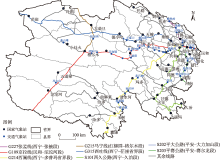
Fig. 1
Distribution of main highway research routes and meteorological stations in Qinghai Province"

Tab. 1
Index factors, weights and data types of rainstorm flood disaster risk in Qinghai Province"
| 目标层因子 | 权重 | 因素层因子 | 权重 | 数据类型 | |
|---|---|---|---|---|---|
| 致灾因子 | 0.42 | 年均小雨日数/d | 0.10 | 气象数据 | |
| 年均中雨日数/d | 0.30 | 气象数据 | |||
| 年累积强降雨日数/d | 0.60 | 气象数据 | |||
| 孕灾环境 | 0.25 | 地形起伏度/% | 0.26 | 环境数据 | |
| 河网密度/km·km-2 | 0.42 | 环境数据 | |||
| 植被覆盖度/% | 0.32 | 环境数据 | |||
| 承灾体 | 0.21 | 人口密度/人·km-2 | 0.11 | 人口密度数据 | |
| 地均耕地面积/m2 | 0.35 | 耕地密度数据 | |||
| 地均大牲畜数量/头 | 0.30 | 地均大牲畜数量 | |||
| 地均可利用草场面积/hm2 | 0.24 | 可利用草场面积 | |||
| 防灾减灾能力 | 0.12 | 人均GDP/104元·人-1 | 1.00 | 人均GDP |
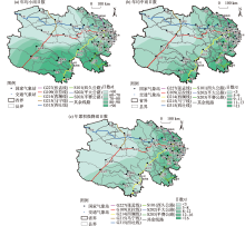
Fig. 2
Spatial distribution characteristics of different rainfall days along highways in Qinghai Province"

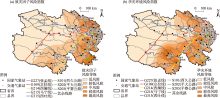
Fig. 3
Spatial distributions of disaster-causing factors and disaster-pregnant environmental risk indices along highways in Qinghai Province"

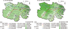
Fig. 4
Spatial distributions of risk indices of disaster bearing bodies and disaster prevention and reduction capability along highways in Qinghai Province"


Fig. 5
Distribution of rainstorm and flood risk comprehensive index along highways in Qinghai Province"

Tab. 2
Classification criteria of rainstorm flood hazard risk models along highways in Qinghai Province"
| 等级 | 强降水 | 评估风险 | 影响建议 |
|---|---|---|---|
| 1级 | MDRI≤0.58 | 最低风险 | 暴雨洪涝灾害风险很小,对交通无影响。 |
| 2级 | 0.58<MDRI≤0.61 | 次低风险 | 暴雨洪涝灾害风险较小,对交通影响不大。 |
| 3级 | 0.61<MDRI≤0.63 | 中等风险 | 暴雨洪涝灾害风险较大,对交通影响较大。 |
| 4级 | 0.63<MDRI≤0.65 | 次高风险 | 暴雨洪涝灾害风险很大,对交通运行影响很大。 |
| 5级 | MDRI>0.65 | 最高风险 | 暴雨洪涝灾害风险极大,对交通运行影响极大。 |
| [1] | 黄荣辉, 杜振彩. 全球变暖背景下中国旱涝气候灾害的演变特征及趋势[J]. 自然杂志, 2010, 32(4): 187-195. |
| [Huang Ronghui, Du Zhencai. Evolution characteristics and trends of droughts and floods in China under the background of global warming[J]. Chinese Journal of Nature, 2010, 32(4): 187-195.] | |
| [2] | 史培军. 中国自然灾害、减灾建设与可持续发展[J]. 自然资源学报, 1995, 10(3): 267-278. |
| [Shi Peijun. The natural disasters, constructions works for disaster reduction and sustainable development of China[J]. Journal of Natural Resources, 1995, 10(3): 267-278.] | |
| [3] | 何宗宜, 韩用顺. 基于GIS技术的洪水淹没计算分析系统[J]. 地理空间信息, 2003, 1(3): 5-7. |
| [He Zongyi, Han Yongshun. Flood drowning analysis system based on GIS[J]. Geospatial Information, 2003, 1(3): 5-7.] | |
| [4] | 刘艳, 何清, 戴晓爱, 等. 新疆铁路沿线主要气象灾害风险区划及减灾对策探讨[J]. 自然灾害学报, 2016, 27(3): 48-57. |
| [Liu Yan, He Qing, Dai Xiaoai, et al. Risk mapping of main meteorological disasters and disaster mitigation startegies for Xinjiang Railway lines[J]. Journal of Natural Disasters, 2016, 27(3): 48-57.] | |
| [5] | 汪超, 罗喜平. 基于GIS的贵州省道路结冰灾害风险区划分析[J]. 高原山地气象研究, 2017, 38(3): 71-77. |
| [Wang Chao, Luo Xiping. Analysis of icy road disaster risk zoning in Guizhou Province base on GIS[J]. Plateau and Mountain Meteorology Research, 2017, 38(3): 71-77.] | |
| [6] | 董鹏捷, 王建捷. 北京地区冰雹灾害风险评估模型及风险区划[J]. 暴雨灾害, 2012, 31(1): 29-34. |
| [Dong Pengjie, Wang Jianjie. Risk assessment model and regionalization of hail disaster in Beijing area[J]. Torrential Rain and Disasters, 2012, 31(1): 29-34.] | |
| [7] | 代娟, 崔新强, 刘文清, 等. 高速铁路气象灾害风险分析与区划方法探讨[J]. 灾害学, 2016, 31(4): 33-36. |
| [Dai Juan, Cui Xinqiang, Liu Wenqing, et al. Research on meteorological disaster risk analysis and regionalization in high speed railway[J]. Journal of Catastrophology, 2016, 31(4): 33-36.] | |
| [8] | 高展, 许剑勇, 王胜, 等. 黄山风景区暴雨山洪灾害风险区划研究[J]. 暴雨灾害, 2015, 34(3): 281-285. |
| [Gao Zhan, Xu Jianyong, Wang Sheng, et al. Research on regional risk zonation of mountain torrent disasters in Huangshan Scenic Area[J]. Torrential Rain and Disasters, 2015, 34(3): 281-285.] | |
| [9] | 朱小凡, 张明军, 王圣杰, 等. 1962—2012年青海省降雪初始终止日期和降雪日数时空变化特征[J]. 生态学杂志, 2014, 33(3): 761-770. |
| [Zhu Xiaofan, Zhang Mingjun, Wang Shengjie, et al. Spatiotemporal variation patterns of the beginning and ending dates of snowfall, and snowfall days in Qinghai Province during 1962 to 2012[J]. Chinese Journal of Ecology, 2014, 33(3): 761-770.] | |
| [10] |
宁贵财, 康彩燕, 陈东辉, 等. 2005—2014年我国不利天气条件下交通事故特征分析[J]. 干旱气象, 2016, 34(5): 753-762.
doi: 10.11755/j.issn.1006-7639(2016)-05-0753 |
|
[Ning Guicai, Kang Caiyan, Chen Donghui, et al. Analysis of characteristics of traffic accidents under adverse weather conditions in China during 2005—2014[J]. Journal of Arid Meteorology, 2016, 34(5): 753-762.]
doi: 10.11755/j.issn.1006-7639(2016)-05-0753 |
|
| [11] | 陈晓光, 李俊超, 李长林, 等. 风吹雪对公路交通的危害及其对策研讨[J]. 公路, 2001, 46(6): 113-118. |
| [Chen Xiaoguang, Li Junchao, Li Changlin, et al. Study on the hazards of wind-blown snow in highway traffic and its countermeasures[J]. Highway, 2001, 46(6): 113-118.] | |
| [12] | 胡钰玲, 康延臻, 杨旭, 等. 2008—2015年北京高速公路道面结冰特征分析[J]. 冰川冻土, 2017, 39(4): 811-823. |
| [Hu Yuling, Kang Yanzhen, Yang Xu, et al. An analysis of the temporal-spatial characteristics of highway surface freezing in Beijing from 2008 to 2015[J]. Journal of Glaciology and Geocryology, 2017, 39(4): 811-823.] | |
| [13] | 李刚, 罗喜平, 韩晓令. 贵州中西部道路结冰气象影响因子检验评估[J]. 贵州气象, 2016, 55(4): 6-10. |
| [Li Gang, Luo Xiping, Han Xiaoling. Validation and assessment of road icing impact factors in midwest of Guizhou[J]. Journal of Guizhou Meteorology, 2016, 55(4): 6-10.] | |
| [14] | 罗生洲, 汪青春, 戴升. 青海省气象灾害的若干气候特征分析[J]. 冰川冻土, 2012, 34(6): 1380-1387. |
| [Luo Shengzhou, Wang Qingchun, Dai Sheng. An analysis of climatic characteristics of meteorological disasters in Qinghai Province[J]. Journal of Glaciology and Geocryology, 2012, 34(6): 1380-1387.] | |
| [15] | 保广裕, 王文英, 张景华, 等. 青海省路结冰变化时空分布特征及其影响等级划分[J]. 气象科技, 2016, 44(1): 104-110. |
| [Bao Guangyu, Wang Wenying, Zhang Jinghua, et al. Temporal-spatial distribution of road icing in Qinghai and its impact[J]. Meteorological Science and Technology, 2016, 44(1): 104-110.] | |
| [16] | 保广裕, 周丹, 郑玲, 等. 青海省公路沿线强降雪天气灾害风险区划方法研究[J]. 沙漠与绿洲气象, 2019, 13(4): 109-116. |
| [Bao Guangyu, Zhou Dan, Zheng Ling, et al. A study of severe snowfall disaster risk zoning along highway in Qinghai Province[J]. Desert and Oasis Meteorology, 2019, 13(4): 109-116.] | |
| [17] | 保广裕, 杨春华, 周丹, 等. 京藏高速柴达木腹地路面温度变化特征及与气温要素影响分析[J]. 干旱区地理, 2021, 44(5): 1213-1221. |
| [Bao Guangyu, Yang Chunhua, Zhou Dan, et al. Variation characteristics of road surface temperature and its influence on air temperature factors of Beijing-Tibet Expressway in the Qaidam Hinterland[J]. Arid Land Geography, 2021, 44(5): 1213-1221.] | |
| [18] | 代青措, 保广裕, 祁栋林, 等. 京藏高速青海东部地区汛期路面水膜厚度变化特征及预报模型构建[J]. 干旱区地理, 2022, 45(6): 1814-1823. |
| [Dai Qingcuo, Bao Guangyu, Qi Donglin, et al. Variation characteristics of pavement water film thickness in flood season and construction of forecast model for Beijing-Tibet Expressway in the eastern part of Qinghai[J]. Arid Land Geography, 2022, 45(6): 1814-1823.] | |
| [19] | 陈真莲. 小流域山洪灾害成因及防治技术研究[D]. 广州: 华南理工大学, 2014. |
| [Chen Zhenlian. Study on cause and prevention technology of mountain torrent disaster in small watershed[D]. Guangzhou: South China University of Technology, 2014.] | |
| [20] | 谢五三, 田红, 卢燕宇. 基于FloodArea模型的大通河流域暴雨洪涝灾害风险评估[J]. 暴雨灾害, 2015, 34(4): 384-387. |
| [Xie Wusan, Tian Hong, Lu Yanyu. Risk evaluation of rainstorm and flood disasters in Datong River Basin based on the flood area model[J]. Torrential Rain and Disasters, 2015, 34(4): 384-387.] | |
| [21] | 刘家福, 李京, 刘荆, 等. 基于GIS/AHP集成的洪水灾害综合风险评价:以淮河流域为例[J]. 自然灾害学报, 2008, 17(6): 110-114. |
| [Liu Jiafu, Li Jing, Liu Jing, et al. Integration GIS/AHP-based flood risk assessment: A case study of Huaihe River Basin in China[J]. Journal of Natural Disasters, 2008, 17(6): 110-114.] | |
| [22] | 管珉, 陈兴旺. 江西省山洪灾害风险区划初步研究[J]. 暴雨灾害, 2007, 26(4): 339-343. |
| [Guan Min, Chen Xingwang. Research of regional torrent risk zonation in Jiangxi Province[J]. Torrential Rain and Disasters, 2007, 26(4): 339-343.] | |
| [23] | 甘薇薇, 范江琳, 肖天贵, 等. 四川省暴雨过程综合评估模型的研究及建立[J]. 冰川冻土, 2017, 39(6): 1336-1343. |
| [Gan Weiwei, Fan Jianglin, Xiao Tiangui, et al. Research and establishment of a comprehensive evaluation model of rainstorm process in Sichuan Province[J]. Journal of Glaciology and Geocryology, 2017, 39(6): 1336-1343.] | |
| [24] | 王慧, 毛炜峄, 李元鹏, 等. 新疆易灾暴雨的风险区划[J]. 冰川冻土, 2011, 33(6): 1407-1413. |
| [Wang Hui, Mao Weiyi, Li Yuanpeng, et al. Risk zoning of torrential rain which easily causes damage in Xinjiang region[J]. Journal of Glaciology and Geocryology, 2011, 33(6): 1407-1413.] | |
| [25] | 苏军锋, 肖志强, 魏邦宪, 等. 基于GIS的甘肃省陇南市暴雨灾害风险区划[J]. 干旱气象, 2012, 30(4): 650-655. |
| [Su Junfeng, Xiao Zhiqiang, Wei Bangxian, et al. The risk zoning of rainstorm based on GIS in Longnan of Gansu Province[J]. Journal of Arid Meteorology, 2012, 30(4): 650-655.] | |
| [26] | 万昔超, 殷伟量, 孙鹏, 等. 基于云模型的暴雨洪涝灾害风险分区评价[J]. 自然灾害学报, 2017, 26(4): 77-83. |
| [Wan Xichao, Yin Weiliang, Sun Peng, et al. Risk division assessment of rainstorm-flood disasters based on cloud model[J]. Journal of Natural Disasters, 2017, 26(4): 77-83.] | |
| [27] |
唐川, 朱静. 基于GIS的山洪灾害风险区划[J]. 地理学报, 2005, 60(1): 87-94.
doi: 10.11821/xb200501010 |
|
[Tang Chuan, Zhu Jing. A GIS based regional torrent risk zonation[J]. Acta Geographica Sinica, 2005, 60(1): 87-94.]
doi: 10.11821/xb200501010 |
|
| [28] | 祁元, 刘勇, 杨正华, 等. 基于GIS的兰州滑坡与泥石流灾害危险性分析[J]. 冰川冻土, 2012, 34(1): 96-104. |
| [Qi Yuan, Liu Yong, Yang Zhenghua, et al. GIS-based analysis of landslide and debris flow hazard in Lanzhou[J]. Journal of Glaciology and Geocryology, 2012, 34(1): 96-104.] | |
| [29] | 李美娟, 陈国宏, 陈衍泰. 综合评价中指标标准化方法研究[J]. 中国管理科学, 2004, 12(10): 45-48. |
| [Li Meijuan, Chen Guohong, Chen Yantai. Study on target standardization method of comprehensive evaluation[J]. Chinese Journal of Management Science, 2004, 12(10): 45-48.] | |
| [30] |
Karhunen J, Joutsensalo J. Representation and separation of signals using nonlinear PCA type learning[J]. Neural Networks, 1994, 7(1): 113-127.
doi: 10.1016/0893-6080(94)90060-4 |
| [31] | Chen Y L, Zheng Y F. Face recognition for target detection on PCA features with outlier information[C]// 50th Midwest Symposiumon Circuits and Systems. Montreal: Institute of Electrical and Electronic Engineers, 2007: 823-826. |
| [32] | 李万志, 余迪, 冯晓莉, 等. 基于风险度的青海省暴雨洪涝灾害风险评估[J]. 冰川冻土, 2019, 41(3): 680-688. |
| [Li Wanzhi, Yu Di, Feng Xiaoli, et al. Risk assessment of rainstorm and flood disasters based on the hazard grades/indices in Qinghai Province[J]. Journal of Glaciology and Geocryology, 2019, 41(3): 680-688.] | |
| [33] | DB63/T372-2018. 青海省地方标准: 气象灾害标准[S]. 西宁: 青海省质量技术监督局, 2018. |
| [DB63/T372-2018. Local standard of Qinghai Province: Meteorological disaster standard[S]. Xining: Qinghai Provincial Bureau of Quality and Technical Supervision, 2018.] |
| [1] | Gulzar MOMIN, YANG Lianmei, LIU Yan, LI Xinguo. Spatial and temporal distribution of flood disasters and characteristics of disaster-prone environment in Ili River Basin in recent 30 years [J]. Arid Land Geography, 2024, 47(8): 1314-1326. |
| [2] | GAO Fuxin, ZHAO Ling, WEI Qiong. Spatiotemporal pattern and dynamic evolution of rural non-farm employment: A case of Qinghai Province [J]. Arid Land Geography, 2023, 46(12): 2111-2119. |
| [3] | ZHANG Jian-hai, ZHANG Qi, XU De-he, DING Yan. Application of a combined ARIMA-LSTM model based on SPI for the forecast of drought:A case study in Qinghai Province [J]. Arid Land Geography, 2020, 43(4): 1004-1013. |
| [4] |
HUANG Xin, LIU Jian-hong, SHEN Ke-jian, LIU Yong-mei, WANG Lei.
Grassland yield change in Qinghai Province based on MODIS data [J]. Arid Land Geography, 2020, 43(3): 715-725. |
| [5] | YANG Xiao-min, LI Ling-qin, FU Jian-xin, CAO Guang-chao, TANG Zhong-xia, LI Ya-ling, WANG Hao-wen, WANG Rui-qing, LIU Ai-jia. Pattern variation of accessibility and economic linkage at county scale in Qinghai Province from 1986 to 2016 [J]. 干旱区地理, 2018, 41(6): 1376-1387. |
| [6] | HAN Bing-hong, ZHOU Bing-rong, WU Rang, ZHAO Min, NIE Guo-yan, NIU De-cao, FU Hua. Grid-based estimation of drought disaster in Qinghai Province [J]. 干旱区地理, 2018, 41(6): 1194-1203. |
| Viewed | ||||||||||||||||||||||||||||||||||||||||||||||||||
|
Full text 81
|
|
|||||||||||||||||||||||||||||||||||||||||||||||||
|
Abstract 201
|
|
|||||||||||||||||||||||||||||||||||||||||||||||||
Cited |
|
|||||||||||||||||||||||||||||||||||||||||||||||||
| Shared | ||||||||||||||||||||||||||||||||||||||||||||||||||
|
||