Arid Land Geography ›› 2026, Vol. 49 ›› Issue (5): 1074-1086.doi: 10.12118/j.issn.1000-6060.2025.059
• Tourism Geography • Previous Articles Next Articles
BAI Yang1,2( ), ZHAO Ping2(), LI Yongfeng3, CHEN Mingzhu2, SUN Yiyue2
Received:2025-02-10
Revised:2025-04-14
Online:2026-05-25
Published:2026-05-25
Contact:
ZHAO Ping
E-mail:baiyang@xju.edu.cn;107552303135@stu.xju.edu.cn
BAI Yang, ZHAO Ping, LI Yongfeng, CHEN Mingzhu, SUN Yiyue. Spatial synergistic zoning of geotourism in Xinjiang[J].Arid Land Geography, 2026, 49(5): 1074-1086.
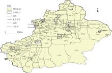
Fig. 1
Schematic diagram of the study area"
Tab. 1
Statistics of geological heritage, A-level scenic spots and infrastructure in Xinjiang"
| 数据类型 | 数据分类 | 数量 |
|---|---|---|
| 地质遗迹 | 基础地质、地貌景观、地质灾害、重要化石产地、地层剖面、水体地貌、岩土体地貌、泥石流、坍塌 | 634 |
| A级景区 | 5A、4A、3A | 509 |
| 基础设施 | “食”:中餐厅、外国餐厅、甜品店、咖啡厅、茶艺馆、糕饼店 | 78690 |
| “住”:星级酒店、宾馆酒店、连锁酒店、青年旅舍、旅馆招待所 | 15532 | |
| “行”:机场、火车站、汽车站、停车场 | 6812 | |
| “购”:商场、超级市场、便民商店/便利店、专卖店、综合市场、服装鞋帽皮具店 | 124446 | |
| “娱”:KTV、电影院、酒吧、棋牌室、游乐场、网吧 | 5216 | |
| “养”:度假养老、山地康养、温泉养生、水体养生、医疗康养、乡村田园康养 | 639 |
Tab. 2
Nearest point index of geological heritage, A-level scenic spots and infrastructure in Xinjiang"
| 要素类型 | 平均观测距离/m | 预期平均距离/m | 最邻近点指数 | Z值 | P值 | 分布类型 | |
|---|---|---|---|---|---|---|---|
| 地质遗迹 | 19200.91 | 35771.13 | 0.54 | -21.03 | 0 | 集聚型 | |
| A级景区 | 14970.82 | 37620.80 | 0.40 | -25.99 | 0 | 集聚型 | |
| 基础设施 | 整体 | 89.06 | 1774.06 | 0.05 | -869.31 | 0 | 集聚型 |
| “食” | 97.98 | 3040.09 | 0.03 | -516.89 | 0 | 集聚型 | |
| “住” | 391.78 | 6826.24 | 0.05 | -224.21 | 0 | 集聚型 | |
| “行” | 1422.93 | 10597.13 | 0.13 | -132.65 | 0 | 集聚型 | |
| “购” | 120.30 | 2418.00 | 0.05 | -638.11 | 0 | 集聚型 | |
| “娱” | 1623.01 | 11752.17 | 0.14 | -119.08 | 0 | 集聚型 | |
| “养” | 7831.01 | 33498.03 | 0.23 | -37.14 | 0 | 集聚型 | |
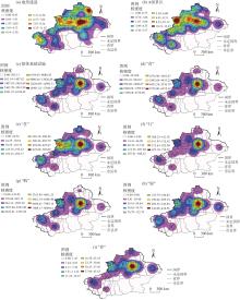
Fig. 2
Kernel density estimates of geological heritage, A-level scenic spots and infrastructure in Xinjiang"
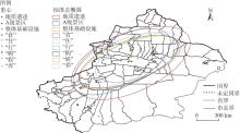
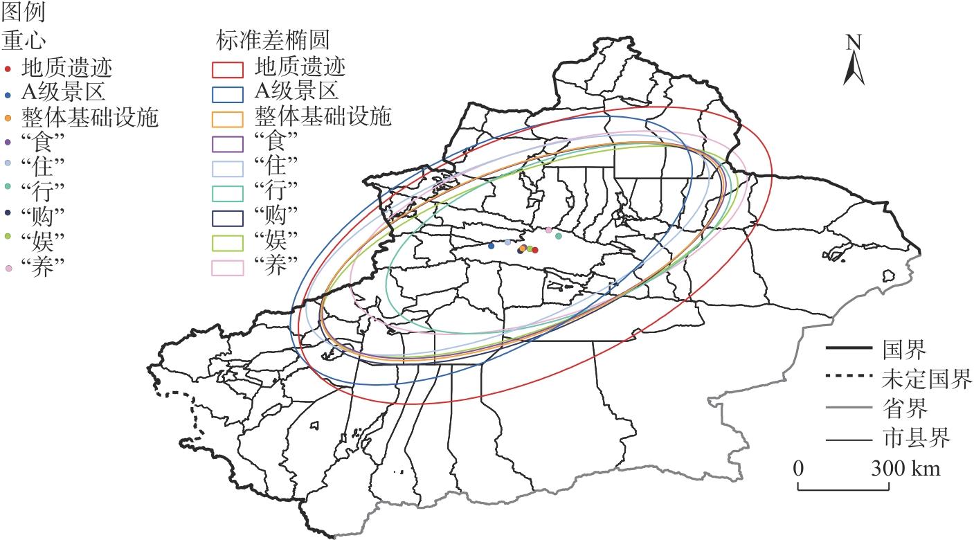
Fig. 3
Standard deviation ellipse and gravity center distribution of geological heritage, A-level scenic spots and infrastructure in Xinjiang"
Tab. 3
Global colocation quotient of geological heritage, A-level scenic spots and infrastructure in Xinjiang"
| 要素类型 | A级景区 | 基础设施 | ||||||
|---|---|---|---|---|---|---|---|---|
| 整体 | “食” | “住” | “行” | “购” | “娱” | “养” | ||
| 地质遗迹 | 0.68 | 0.74 | 0.40 | 0.45 | 0.67 | 0.40 | 0.38 | 0.61 |
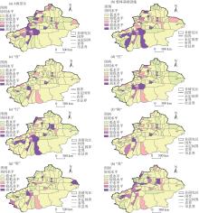
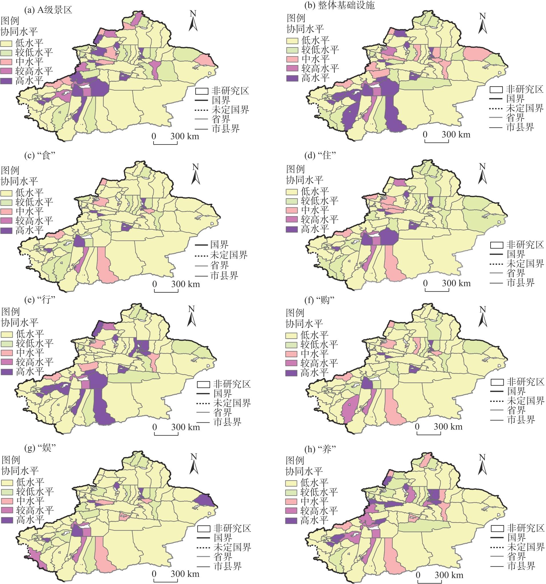
Fig. 4
Local spatial coordination level of geological heritage, A-level scenic spots and infrastructure in Xinjiang"
Tab. 4
Symbiotic coordination level of geological heritage, A-level scenic spots and infrastructure in Xinjiang"
| 共生协调度 | 共生协调等级 | 分布县域 |
|---|---|---|
| 0.8~1.0 | 优质共生协调 | 北疆:阿勒泰市、吐鲁番市高昌区、乌鲁木齐县、新源县、昭苏县等7个县域 |
| 0.6~0.8 | 高级共生协调 | 北疆:巴里坤哈萨克自治县、乌鲁木齐市达坂城区、福海县等21个县域 南疆:阿图什市、巴楚县、博湖县等11个县域 |
| 0.4~0.6 | 中级共生协调 | 北疆:阿拉山口市、昌吉市、额敏县等15个县域 南疆:伽师县、民丰县、墨玉县等17个县域 |
| 0.2~0.4 | 初级共生濒临失调 | 北疆:霍尔果斯市、克拉玛依市白碱滩区、吉木乃县、青河县、伊吾县 南疆:策勒县、轮台县、麦盖提县等13个县域 |
| 0.0~0.2 | 勉强共生失调 | 北疆:乌鲁木齐市沙依巴克区、头屯河区、天山区、新市区和奎屯市、伊宁市 南疆:喀什市 |
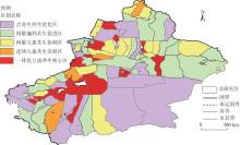
Fig. 5
Geotourism synergistic zoning in Xinjiang"

Tab. 5
Spatial collaborative zoning of geotourism in Xinjiang"
| 区划名称 | 要素特征(资源数量比重排名前3) | 地质遗迹与基础设施协同水平(设施类型) | 涵盖县域 | 开发模式 | 优化路径 |
|---|---|---|---|---|---|
| 一体化互惠共生核心区 | 地质遗迹(岩土体地貌、地层剖面和水体地貌、重要化石产地);A级景区(人文景观综合体、实用建筑与核心设施、湖沼) | 较高(“住”“行”“养”“娱”);中(“食”“购”) | 巴楚县、巩留县、精河县等18个县域 | 以景带地,推动个性化开发与可持续发展 | 依托A级景区带动地质遗迹资源利用与开发 |
| 连续互惠共生发 展区 | 地质遗迹(水体地貌、重要化石产地、构造地貌);A级景区(人文综合景观、植被景观和实用建筑与核心设施、地表形态) | 较高(“养”);中(“食”“住”“行”“购”“娱”) | 布尔津县、新源县、温宿县等6个县域 | 地景兼修,强化品牌建设和特色开发 | 开发特色地质旅游产品,挖掘区域文化特征 |
| 间歇互惠共生协 调区 | 地质遗迹(水体地貌、地层剖面、岩土体地貌);A级景区(人文综合景观、植被景观、实用建筑与核心设施) | 中(“行”“养”);较低(“食”“住”“娱”“养”) | 阿合奇县、阿勒泰市、巴里坤哈萨克自治县等17个县域 | 景地相融,坚持整合化与市场化运营 | 以加强A级景区和地质遗迹融合为主线,形成联合开发机制 |
| 间歇偏利共生促 进区 | 地质遗迹(水体地貌、岩土体地貌、重要化石产地);A级景区(人文景观综合体、植被景观、实用建筑与核心设施) | 较低(“食”“住”“行”“购”“娱”“养”) | 博乐市、阿图什市、博湖县等25个县域 | 以地促景,提供协同化与均衡化服务 | 充分发挥5A级景区优势,加强县域合作力度 |
| 点寄生共生优化区 | 地质遗迹(水体地貌、岩土体地貌、地层剖面);A级景区(人文景观综合体、植被景观、实用建筑与核心设施) | 较低(“行”“养”);低(“食”“住”“购”“娱”) | 阿拉山口市、克拉玛依市白碱滩区、策勒县等30个县域 | 地景择优,加强品质提升与规范引领 | 择优选取地质旅游资源,提升服务质量,加快建设旅游基础设施 |
| [1] | 吴昭谦. 面向世界开展地质旅游[J]. 旅游学刊, 1990(1): 54-57. |
| [Wu Zhaoqian. Open up to the world and develop geological tourism[J]. Tourism Tribune, 1990(1): 54-57.] | |
| [2] |
Thomas A H. The English origins of geotourism (as a vehicle for geocon servation) and their relevance to current studies[J]. Acta geographica Slovenica, 2011, 51(2): 343-360.
doi: 10.3986/AGS51302 |
| [3] | 赵逊, 赵汀. 从地质遗迹的保护到世界地质公园的建立[J]. 地质论评, 2003(4): 389-399. |
| [Zhao Xun, Zhao Ting. The process from the geoheritage conservation to the construction of world geoparks[J]. Geological Review, 2003(4): 389-399.] | |
| [4] | 郝俊卿, 李丹丹, 曹晓娟. 我国地质遗迹的概念、范畴与研究进展——基于2000-2020年间文献可视化分析[J]. 干旱区资源与环境, 2021, 35(7): 136-143. |
| [Hao Junqing, Li Dandan, Cao Xiaojuan. Concept, research scope and research progress of geological heritage in China[J]. Journal of Arid Land Resources and Environment, 2021, 35(7): 136-143.] | |
| [5] |
解智涵, 刘敏, 闫旭纲. 山西重要地质遗迹空间分布特征及旅游响应[J]. 地理研究, 2024, 43(7): 1809-1826.
doi: 10.11821/dlyj020230792 |
| [Xie Zhihan, Liu Min, Yan Xugang. Spatial distribution characteristics and tourism response of important geological heritage in Shanxi[J]. Geographical Research, 2024, 43(7): 1809-1826.] | |
| [6] | 穆桂松, 万三敏. 河南地质旅游资源区划与开发研究[J]. 地域研究与开发, 2005(5): 88-91. |
| [Mu Guisong, Wan Sanmin. Study on the dividing geologic travelling resource into districts in Henan Province[J]. Areal Research and Development, 2005(5): 88-91.] | |
| [7] | 陈安泽, 卢云亭, 张尔匡, 等. 旅游地学大辞典[M]. 北京: 科学出版社, 2013: 2-4. |
| [Chen Anze, Lu Yunting, Zhang Erkuang, et al. A grand tourism earth science dictionary[M]. Beijing: Science Press, 2013: 2-4.] | |
| [8] | Newsome D, Moore S, Dowling R K. Natural area tourism: Ecology, impacts and management[M]. Bristol: Channel View Publications, 2012: 26-27. |
| [9] | Megerle A. National geoparks and geotourism in Germany: Framework and case study Baden-Wuerttemberg and Swabian Alb[J]. World Geoparks Newsl, 2005(1): 10-15. |
| [10] | 赵汀, 赵逊. 地质遗迹分类学及其应用[J]. 地球学报, 2009, 30(3): 309-310. |
| [Zhao Ting, Zhao Xun. Geoheritage taxonomy and its application[J]. Acta Geoscientica Sinica, 2009, 30(3): 309-310.] | |
| [11] | Fuertes-Gutierrez I, Fernandez-Martinez E. Geosites inventory in the Leon Province (northwestern Spain): A tool to introduce geoheritage into regional environmental management[J]. Geoheritage, 2010(2): 57-75. |
| [12] |
Miller N P. US National Parks and management of park soundscapes: A review[J]. Applied Acoustics, 2008, 69(2): 77-92.
doi: 10.1016/j.apacoust.2007.04.008 |
| [13] | 孙克勤. 地质旅游[M]. 北京: 地质出版社, 2011: 150-159. |
| [Sun Keqin. Geotourism[M]. Beijing: Geological Publishing House, 2011: 150-159.] | |
| [14] | 王清利, 常捷, 张吉献. 地质旅游资源分类及开发利用初探[J]. 河南大学学报(自然科学版), 2003(2): 63-66. |
| [Wang Qingli, Chang Jie, Zhang Jixian. Preliminary study on the classification of geological tourism resources and its exploitation[J]. Journal of Henan University (Natural Science Edition), 2003(2): 63-66.] | |
| [15] | 郭威, 丁华. 论地质旅游资源[J]. 西安工程学院学报, 2001(3): 60-63. |
| [Guo Wei, Ding Hua. The geological tourism resources[J]. Journal of Earth Sciences and Environment, 2001(3): 60-63.] | |
| [16] | 王立操, 江海旭. 大连市地质旅游资源评价及可持续发展研究[J]. 河南科学, 2011, 29(2): 243-247. |
| [Wang Licao, Jiang Haixu. Evaluation of geological tourism resources and research on sustainable development of Dalian[J]. Henan Science, 2011, 29(2): 243-247.] | |
| [17] | 王钦军, 陈玉, 周红英. 三亚市地质旅游资源调查与评价[J]. 海南师范大学学报(自然科学版), 2017, 30(4): 443-449. |
| [Wang Qinjun, Chen Yu, Zhou Hongying. Investigation and evaluation of Sanya geological tourism resources[J]. Journal of Hainan Normal University (Natural Science Edition), 2017, 30(4): 443-449.] | |
| [18] |
解智涵, 刘敏, 闫旭纲, 等. 黄河流域重要地质遗迹空间格局及地质旅游开发潜力评价[J]. 中国沙漠, 2024, 44(3): 128-139.
doi: 10.7522/j.issn.1000-694X.2024.00004 |
|
[Xie Zhihan, Liu Min, Yan Xugang, et al. Spatial pattern of important geological remains and evaluation of geotourism development potential in the Yellow River Basin[J]. Journal of Desert Research, 2024, 44(3): 128-139.]
doi: 10.7522/j.issn.1000-694X.2024.00004 |
|
| [19] | 范文静, 唐承财. 地质遗产区旅游产业融合路径探析——以黄河石林国家地质公园为例[J]. 资源科学, 2013, 35(12): 2376-2383. |
| [Fan Wenjing, Tang Chengcai. Geological heritage area tourism development and industry convergence: A case study on Yellow River Stone Forest[J]. Resources Science, 2013, 35(12): 2376-2383. | |
| [20] | 王蕾. 广西地质公园空间分布差异及可持续发展路径研究[D]. 武汉: 中国地质大学, 2018. |
| [Wang Lei. Research on the spatial differentiation and sustainable development pathways of geoparks in Guangxi Zhuang Autonomous Region[D]. Wuhan: China University of Geosciences, 2018.] | |
| [21] | 李仁杰, 路紫, 李继峰. 山岳型风景区观光线路景观感知敏感度计算方法——以武安国家地质公园奇峡谷景区为例[J]. 地理学报, 2011, 66(2): 244-256. |
| [Li Renjie, Lu Zi, Li Jifeng. The calculation method of landscape perception sensitivity on sightseeing route in ecotourism destinations: A case study of Qixiagu Scenic Region in Wu’an National Geopark[J]. Acta Geographica Sinica, 2011, 66(2): 244-256.] | |
| [22] |
张仲福. 黄河流域甘肃段地质遗迹空间区划及可持续开发利用策略[J]. 干旱区地理, 2022, 45(4): 1235-1243.
doi: 10.12118/j.issn.1000-6060.2022.049 |
|
[Zhang Zhongfu. Spatial division and sustainable development and utilization strategy of geological relics in Gansu section of the Yellow River Basin[J]. Arid Land Geography, 2022, 45(4): 1235-1243.]
doi: 10.12118/j.issn.1000-6060.2022.049 |
|
| [23] | 丁华, 张茂省, 苟青青, 等. 关中盆地城市群地质遗迹特征及可持续开发利用[J]. 西北地质, 2019, 52(2): 37-45. |
| [Ding Hua, Zhang Maosheng, Gou Qingqing, et al. Characteristics and sustainable development & utilization of geological relics in Guanzhong Basin urban agglomeration[J]. Northwestern Geology, 2019, 52(2): 37-45.] | |
| [24] | 李翠林, 田晓霞. 新疆地质遗迹景观旅游开发动力机制构建[J]. 国土与自然资源研究, 2013(2): 79-81. |
| [Li Cuilin, Tian Xiaoxia. The tourism development driving mechanism of geological heritage in Xinjiang[J]. Territory & Natural Resources Study, 2013(2): 79-81.] | |
| [25] |
冉歆一, 魏峰群, 马文硕, 等. 关中地区传统村落的聚落发展与文化传承共生协调评价及交互作用研究[J]. 干旱区地理, 2024, 47(8): 1431-1442.
doi: 10.12118/j.issn.1000-6060.2024.062 |
|
[Ran Xinyi, Wei Fengqun, Ma Wenshuo, et al. Evaluation of symbiotic coordination and interaction between settlement development and cultural inheritance of traditional villages in Guanzhong[J]. Arid Land Geography, 2024, 47(8): 1431-1442.]
doi: 10.12118/j.issn.1000-6060.2024.062 |
|
| [26] |
白洋, 吴剑, 窦开龙, 等. 兵地旅游经济网络结构及共生发展研究[J]. 干旱区地理, 2023, 46(12): 2086-2097.
doi: 10.12118/j.issn.1000-6060.2023.223 |
|
[Bai Yang, Wu Jian, Dou Kailong, et al. Research on the network structure and symbiotic development of tourism economy in Xinjiang Production and Construetion Corps and local government[J]. Arid Land Geography, 2023, 46(12): 2086-2097.]
doi: 10.12118/j.issn.1000-6060.2023.223 |
|
| [27] |
谢朝武, 赖菲菲, 黄锐, 等. 中国出境旅游安全事件集群: 空间分异及组态致因[J]. 地理研究, 2023, 42(5): 1177-1199.
doi: 10.11821/dlyj020220866 |
| [Xie Chaowu, Lai Feifei, Huang Rui, et al. China’s outbound tourism safety incidents cluster: Spatial differentiation and configuration causes[J]. Geographical Research, 2023, 42(5): 1177-1199.] | |
| [28] |
聂拼, 梁明, 李玉洁, 等. 基于最邻近时空距离的土地变化过程时空模式分析[J]. 地球信息科学学报, 2020, 22(3): 628-637.
doi: 10.12082/dqxxkx.2020.190569 |
| [Nie Pin, Liang Ming, Li Yujie, et al. Spatiotemporal model analysis of land change process based on nearest spatiotemporal distance[J]. Journal of Geo-Information Science, 2020, 22(3): 628-637.] | |
| [29] |
许玉洁, 刘曙光. 黄河流域绿色创新效率空间格局演化及其影响因素[J]. 自然资源学报, 2022, 37(3): 627-644.
doi: 10.31497/zrzyxb.20220306 |
|
[Xu Yujie, Liu Shuguang. Spatial pattern evolution and influencing factors of green innovation efficiency in the Yellow River Basin[J]. Journal of Natural Resources, 2022, 37(3): 627-644.]
doi: 10.31497/zrzyxb.20220306 |
|
| [30] |
孟斌, 高丽萍, 李若倩. 基于协同区位商的北京城市职住要素空间关联[J]. 地理学报, 2021, 76(6): 1380-1393.
doi: 10.11821/dlxb202106005 |
|
[Meng Bin, Gao Liping, Li Ruoqian. Spatial correlation analysis of residential and employment elements in Beijing based on collaborative location quotient[J]. Acta Geographica Sinica, 2021, 76(6): 1380-1393.]
doi: 10.11821/dlxb202106005 |
|
||