Arid Land Geography ›› 2026, Vol. 49 ›› Issue (2): 356-368.doi: 10.12118/j.issn.1000-6060.2025.118
• Climatology and Hydrology • Previous Articles Next Articles
CAO Xiaoyun1,2( ), ZHOU Bingrong1,2, LEI Chunmiao2,3(), LIU Zhiyuan1,2, SHI Feifei1,2, YAN Yuqian1,2
Received:2025-03-06
Revised:2025-05-26
Online:2026-02-25
Published:2026-02-27
Contact:
LEI Chunmiao
E-mail:xiaoyun_cao@126.com;mmnnff22@126.com
CAO Xiaoyun, ZHOU Bingrong, LEI Chunmiao, LIU Zhiyuan, SHI Feifei, YAN Yuqian. Spatiotemporal changes of snow depth and climate attribution in the Three River Source Region from 1980 to 2020 based on remote sensing monitoring[J].Arid Land Geography, 2026, 49(2): 356-368.
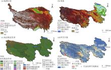
Fig. 1
Schematic diagram of the study area"

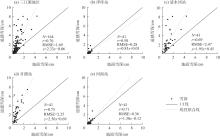
Fig. 2
Scatter plot of the correlation between surface snow depth and remotely sensed snow depth in the Three River Source Region from 1980 to 2020"
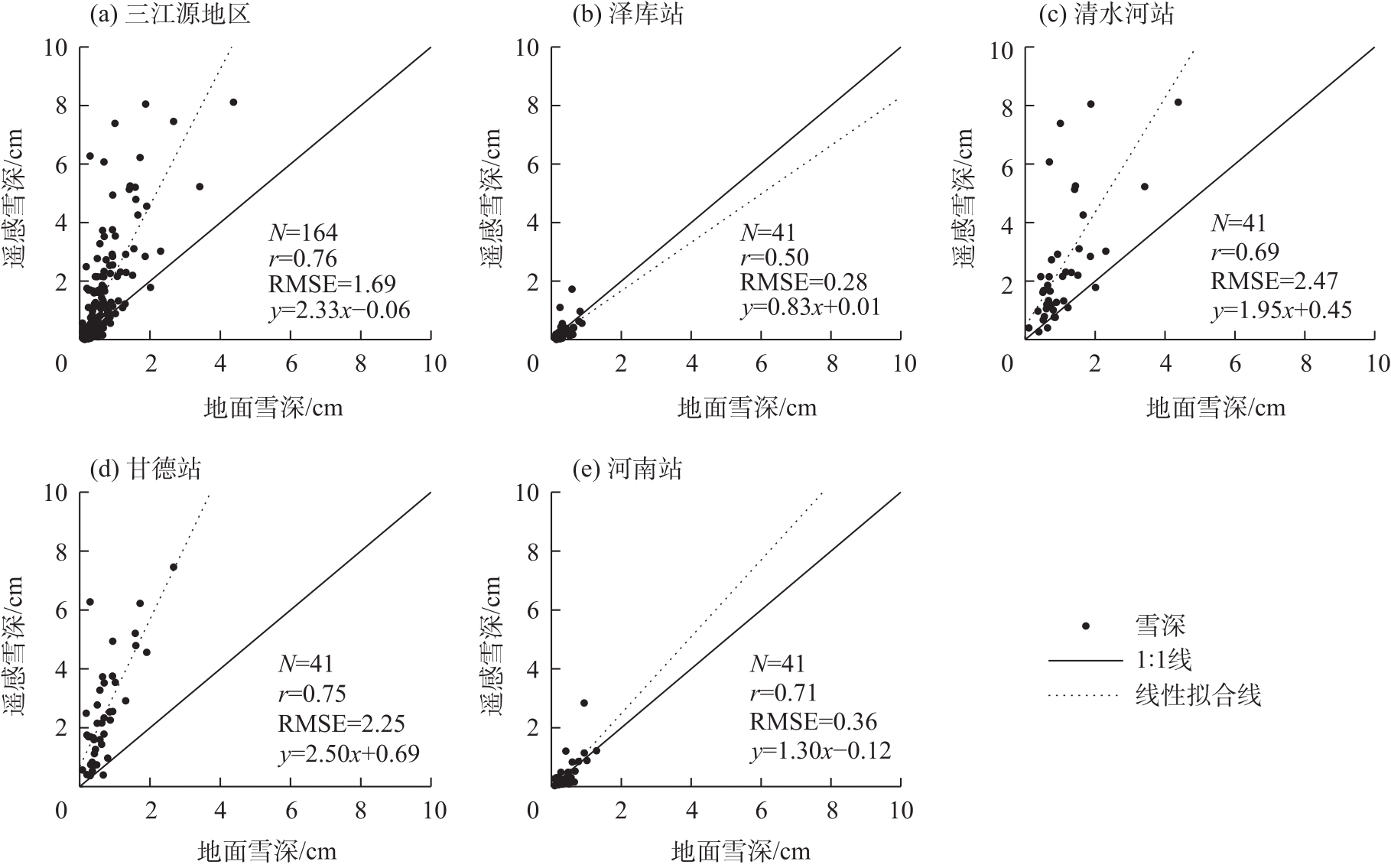
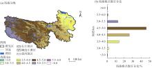
Fig. 3
Elevation classification in the Three River Source Region"
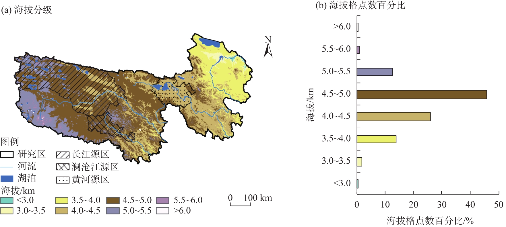

Fig. 4
Spatial distributions and differences in multi-year mean snow depth in the Three River Source Region from 1980 to 2020"
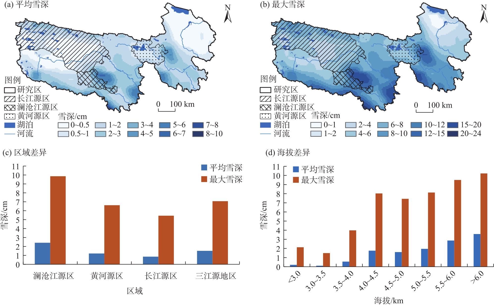
Fig. 5
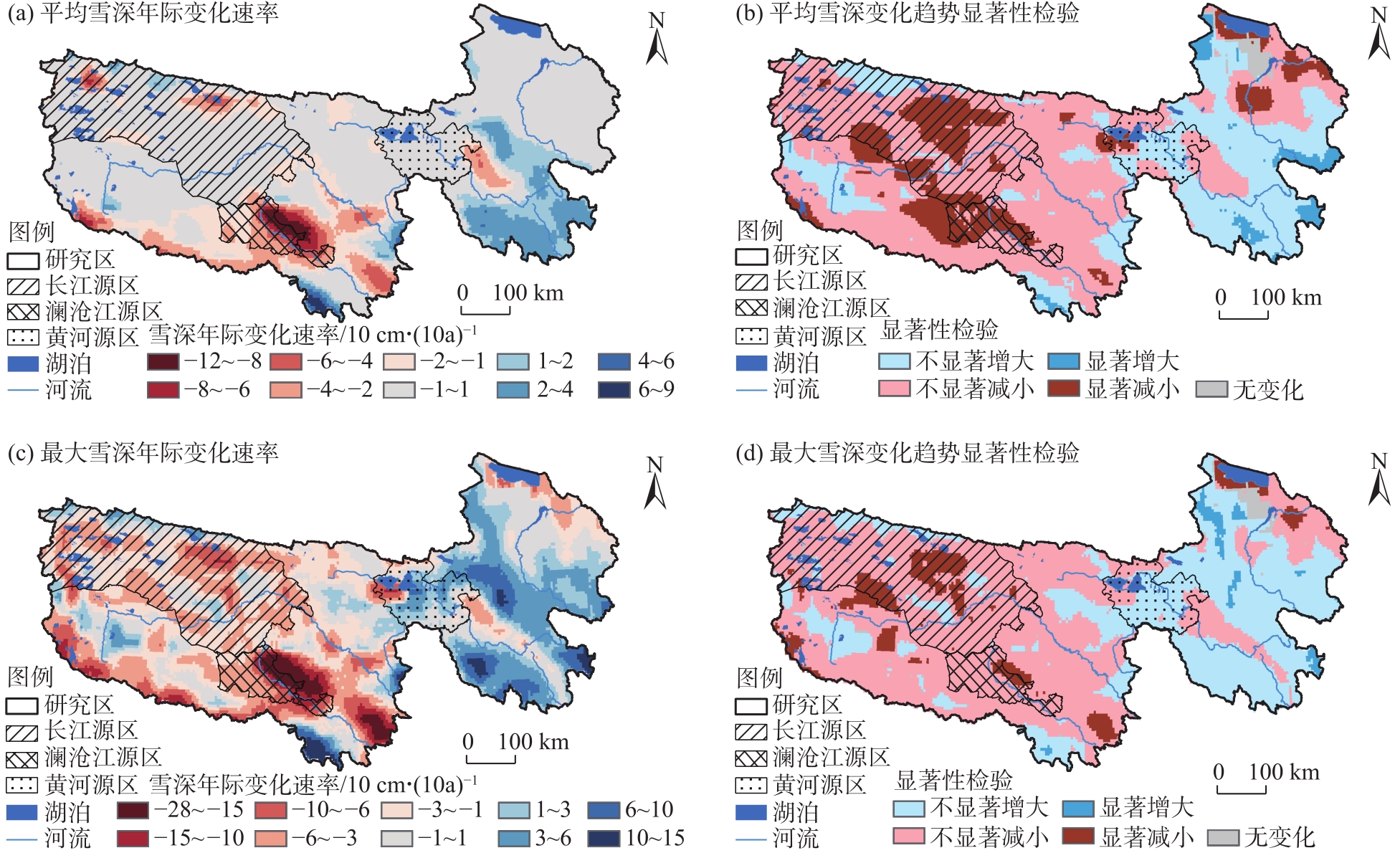
Spatial distributions of interannual variation rate of snow depth and its significance test in the Three River Source Region from 1980 to 2020"
Tab. 1
Interannual variation rate of snow depth and its significance test in different regions of the Three River Source Region from 1980 to 2020"
| 区域 | 年际变化速率 /10 cm·(10a)-1 | 不显著减小面积 占比/% | 显著减小面积 占比/% | 不显著增加面积 占比/% | 显著增加面积 占比/% | 无变化面积 占比/% | |||||||||||
|---|---|---|---|---|---|---|---|---|---|---|---|---|---|---|---|---|---|
| 平均 雪深 | 最大 雪深 | 平均 雪深 | 最大 雪深 | 平均 雪深 | 最大 雪深 | 平均 雪深 | 最大 雪深 | 平均 雪深 | 最大 雪深 | 平均 雪深 | 最大 雪深 | ||||||
| 澜沧江源区 | -3.73 | -8.14 | 43.47 | 90.67 | 56.53 | 9.33 | 0.00 | 0.00 | 0.00 | 0.00 | 0.00 | 0.00 | |||||
| 黄河源区 | -0.15 | 0.31 | 45.79 | 36.58 | 8.28 | 0.00 | 45.79 | 62.35 | 0.13 | 0.00 | 0.00 | 1.07 | |||||
| 长江源区 | -0.62 | -2.58 | 62.06 | 73.42 | 27.45 | 13.32 | 10.10 | 12.51 | 0.00 | 0.00 | 0.39 | 0.76 | |||||
| 三江源地区 | -1.48 | -4.90 | 52.80 | 56.36 | 15.64 | 7.47 | 27.38 | 33.25 | 2.90 | 1.52 | 1.28 | 1.39 | |||||
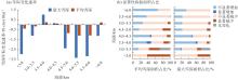
Fig. 6
Interannual variation rates of snow depth in different altitude zones and its significance test area percentage in the Three River Source Region from 1980 to 2020"
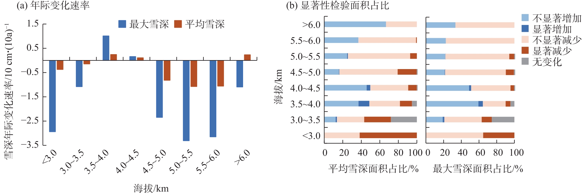
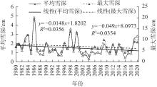
Fig. 7
Interannual variation of snow depth in the Three River Source Region from 1980 to 2020"
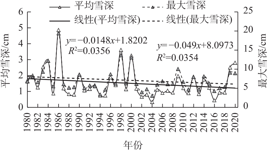
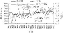
Fig. 8
Interannual variation of temperature and precipitation in the Three River Source Region from 1980 to 2020"

Fig. 9
Partial correlation analysis of snow depth with temperature and precipitation in the Three River Source Region from 1980 to 2020"
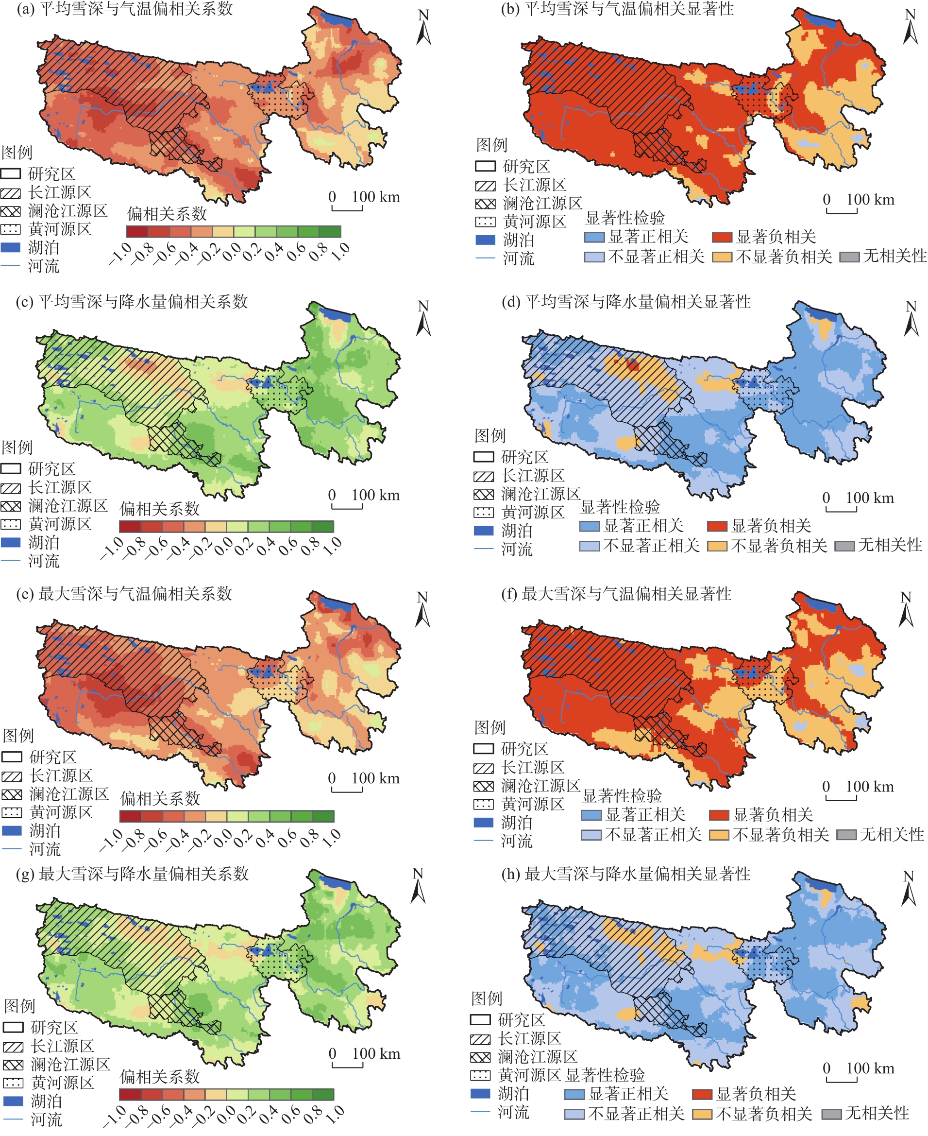
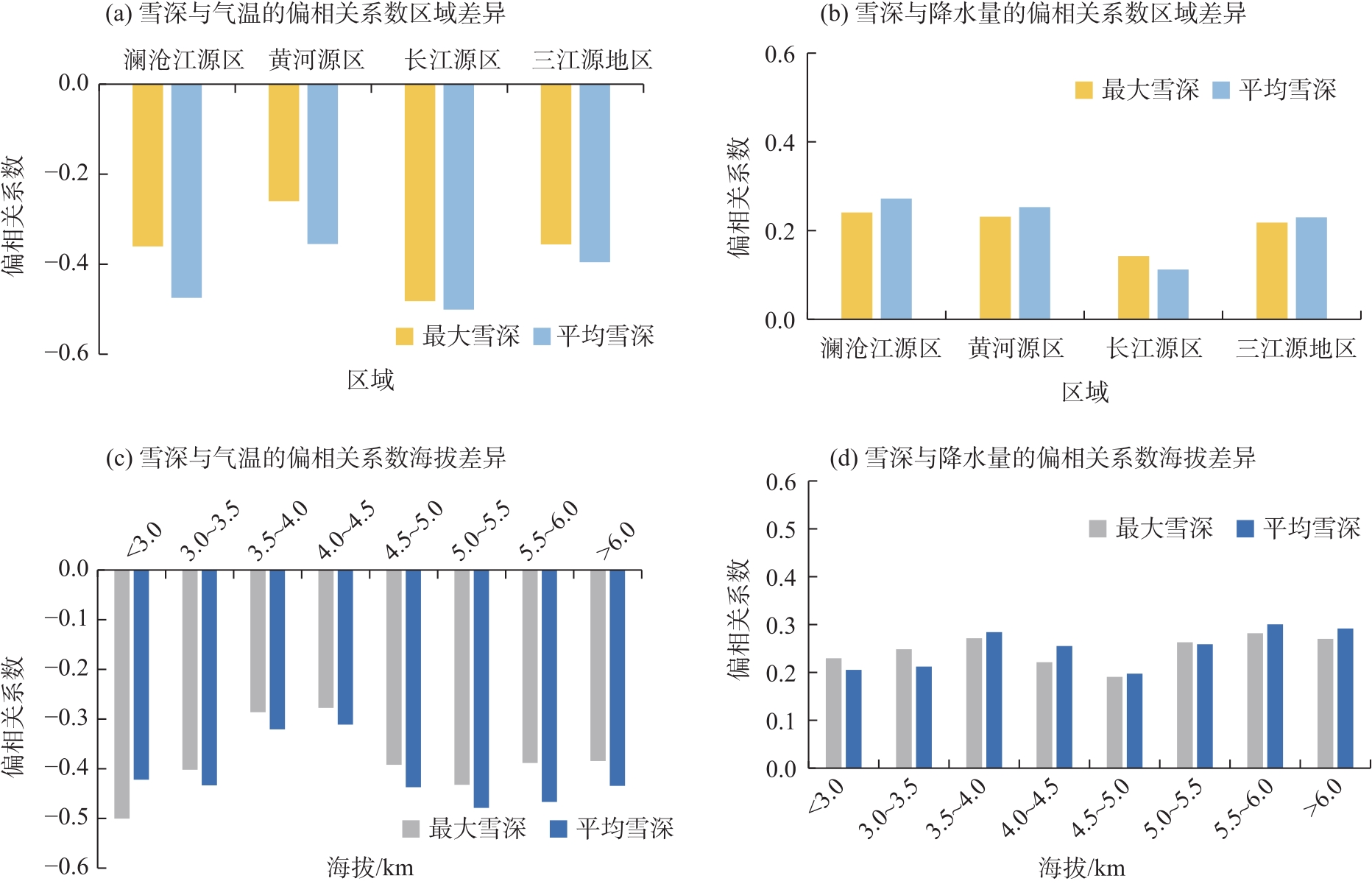
Fig. 10
Differences in bias correlation coefficients of snow depth with temperature and precipitation in the Three River Source Region from 1980 to 2020"
| [1] |
曹晓云, 肖建设, 郝晓华, 等. 2001—2020年三江源地区积雪日数变化及地形分异[J]. 干旱区地理, 2022, 45(5): 1370-1380.
doi: 10.12118/j.issn.1000-6060.2021.599 |
|
[Cao Xiaoyun, Xiao Jianshe, Hao Xiaohua, et al. Variation of snow cover days and topographic differentiation in Sanjiangyuan area from 2001 to 2020[J]. Arid Land Geography, 2022, 45(5): 1370-1380.]
doi: 10.12118/j.issn.1000-6060.2021.599 |
|
| [2] | 车涛, 郝晓华, 戴礼云, 等. 青藏高原积雪变化及其影响[J]. 中国科学院院刊, 2019, 34(11): 1247-1253. |
| [Che Tao, Hao Xiaohua, Dai Liyun, et al. Snow cover variation and its impacts over the Qinghai-Tibet Plateau[J]. Bulletin of Chinese Academy of Sciences, 2019, 34(11): 1247-1253.] | |
| [3] |
王建, 车涛, 李震, 等. 中国积雪特性及分布调查[J]. 地球科学进展, 2018, 33(1): 12-26.
doi: 10.11867/j.issn.1001-8166.2018.01.0012 |
|
[Wang Jian, Che Tao, Li Zhen, et al. Investigation on snow characteristics and their distribution in China[J]. Advances in Earth Science, 2018, 33(1): 12-26.]
doi: 10.11867/j.issn.1001-8166.2018.01.0012 |
|
| [4] | 王宁练, 盛煜, 金汇军, 等. 祁连山水塔变化及其影响[M]. 北京: 科学出版社, 2023: 116-135. |
| [Wang Ninglian, Sheng Yu, Jin Huijun, et al. Changes in the Qilian Mountains water tower and its impacts[M]. Beijing: Science Publishing House, 2023: 116-135.] | |
| [5] | 周秉荣, 袁佳双, 乔斌, 等. 青藏高原气候与冰冻圈变化研究进展[J]. 环境科学研究, 2024, 37(9): 1885-1896. |
| [Zhou Bingrong, Yuan Jiashuang, Qiao Bin, et al. Research progress on climate and cryosphere changes in the Qinghai-Tibetan Plateau[J]. Environmental Science Research, 2024, 37(9): 1885-1896.] | |
| [6] | Gu Q Y, Xu J H, Ni J W, et al. Improved snow depth estimation on the Tibetan Plateau using AMSR2 and ensemble learning models[J]. International Journal of Applied Earth Observation and Geoinformation, 2024, 133: 104102, doi: 10.1016/j.jag.2024.104102. |
| [7] | 王静, 车涛, 戴礼云, 等. 被动微波遥感反演雪深与气象站观测雪深时空对比[J]. 遥感学报, 2023, 27(9): 2060-2071. |
| [Wang Jing, Che Tao, Dai Liyun, et al. Spatio-temporal comparison of snow depth between passive microwave remote sensing inversion data and meteorological station observation data[J]. Journal of Remote Sensing, 2023, 27(9): 2060-2071.] | |
| [8] |
孟宪红, 陈昊, 李照国, 等. 三江源区气候变化及其环境影响研究综述[J]. 高原气象, 2020, 39(6): 1133-1143.
doi: 10.7522/j.issn.1000-0534.2019.00144 |
|
[Meng Xianhong, Chen Hao, Li Zhaoguo, et al. Review of climate change and its environmental influence on the Three-River Regions[J]. Plateau Meteorology, 2020, 39(6): 1133-1143.]
doi: 10.7522/j.issn.1000-0534.2019.00144 |
|
| [9] | Bai Y F, Guo C C, Degen A A, et al. Climate warming benefits alpine vegetation growth in Three-River Headwater Region, China[J]. Science of the Total Environment, 2020, 742: 140574, doi: 10.1016/j.scitotenv.2020.140574. |
| [10] |
王成武, 尧良杰, 汪宙峰, 等. 2000—2020年三江源地区景观生态风险评价及驱动因素[J]. 干旱区研究, 2024, 41(11): 1908-1920.
doi: 10.13866/j.azr.2024.11.11 |
|
[Wang Chengwu, Yao Liangjie, Wang Zhoufeng, et al. Landscape ecological risk assessment and drivers in the Three River Source Region from 2000 to 2020[J]. Arid Zone Research, 2024, 41(11): 1908-1920.]
doi: 10.13866/j.azr.2024.11.11 |
|
| [11] | 姚檀栋, 王伟财, 杨威, 等. 亚洲水塔失衡与冰雪变化[J]. 气候变化研究进展, 2024, 20(6): 689-698. |
| [Yao Tandong, Wang Weicai, Yang Wei, et al. Imbalance of the Asian Water Tower characterized by glacier and snow melt[J]. Climate Change Research, 2024, 20(6): 689-698.] | |
| [12] | 靳铮, 游庆龙, 吴芳营, 等. 青藏高原三江源地区近60 a气候与极端气候变化特征分析[J]. 大气科学学报, 2020, 43(6): 1042-1055. |
| [Jin Zheng, You Qinglong, Wu Fangying, et al. Changes of climate and climate extremes in the Three-Rivers Headwaters Region over the Tibetan Plateau during the past 60 years[J]. Transactions of Atmospheric Sciences, 2020, 43(6): 1042-1055.] | |
| [13] |
刘义花, 李红梅, 申红艳, 等. 三江源地区降雪量演变特征及其对径流的影响[J]. 高原气象, 2022, 41(2): 420-429.
doi: 10.7522/j.issn.1000-0534.2021.00096 |
|
[Liu Yihua, Li Hongmei, Shen Hongyan, et al. The variation characteristics of snowfall and its infulence on runoff in Three-Rivers-Source Region[J]. Plateau Meteorology, 2022, 41(2): 420-429.]
doi: 10.7522/j.issn.1000-0534.2021.00096 |
|
| [14] |
曹晓云, 张娟, 王镜, 等. 近40 年青藏高原雪深变化及对气候变化的响应分析[J]. 高原气象, 2025, 44(5): 1133-1145.
doi: 10.7522/j.issn.1000-0534.2025.00024 |
|
[Cao Xiaoyun, Zhang Juan, Wang Jing, et al. Snow depth and its response to climate change over the Qinghai-Xizang (Tibetan) Plateau in recent 40 years[J]. Plateau Meteorology, 2025, 44(5): 1133-1145.]
doi: 10.7522/j.issn.1000-0534.2025.00024 |
|
| [15] |
陈龙飞, 张万昌, 高会然. 三江源地区1980—2019年积雪时空动态特征及其对气候变化的响应[J]. 冰川冻土, 2022, 44(1): 133-146.
doi: 10.7522/j.issn.1000-0240.2022.0025 |
|
[Chen Longfei, Zhang Wanchang, Gao Huiran. Spatiotemporal dynamic characteristics of snow cover from 1980 to 2019 in the Three-River-Source Region and its response to climate change[J]. Journal of Glaciology and Geocryology, 2022, 44(1): 133-146.]
doi: 10.7522/j.issn.1000-0240.2022.0025 |
|
| [16] |
李红梅, 颜亮东, 温婷婷, 等. 三江源地区气候变化特征及其影响评估[J]. 高原气象, 2022, 41(2): 306-316.
doi: 10.7522/j.issn.1000-0534.2021.00101 |
|
[Li Hongmei, Yan Liangdong, Wen Tingting, et al. Characteristics of climate change and its impact assessment in the Three River Source Region[J]. Plateau Meteorology, 2022, 41(2): 306-316.]
doi: 10.7522/j.issn.1000-0534.2021.00101 |
|
| [17] | 史飞飞, 李晓东, 肖建设, 等. 基于MOD10A1 V6产品下青海省各片区积雪的分布气候特征[J]. 生态科学, 2024, 43(4): 27-38. |
| [Shi Feifei, Li Xiaodong, Xiao Jianshe, et al. Climate characteristics of snow cover distribution in ecological function areas of Qinghai Province based on MOD10A1 V6[J]. Ecological Science, 2024, 43(4): 27-38.] | |
| [18] |
黄晓东, 马英, 李雨馨, 等. 1980—2020年青藏高原积雪时空变化特征[J]. 冰川冻土, 2023, 45(2): 423-434.
doi: 10.7522/j.issn.1000-0240.2023.0032 |
|
[Huang Xiaodong, Ma Ying, Li Yuxin, et al. Spatiotemporal variation characteristics of snow cover over the Tibetan Plateau from 1980 to 2020[J]. Journal of Glaciology and Geocryology, 2023, 45(2): 423-434.]
doi: 10.7522/j.issn.1000-0240.2023.0032 |
|
| [19] | 效存德, 杨佼, 张通, 等. 冰冻圈变化的可预测性、不可逆性和深度不确定性[J]. 气候变化研究进展, 2022, 18(1): 1-11. |
| [Xiao Cunde, Yang Jiao, Zhang Tong, et al. The predictability, irreversibility and deep uncertainty of cryospheric change[J]. Climate Change Research, 2022, 18(1): 1-11.] | |
| [20] | 车涛, 戴礼云, 李新. 中国雪深长时间序列数据集(1979—2023)[DB/OL]. [2024-09-24]. https://www.tpdc.ac.cn/zh-hans/data/df40346a-0202-4ed2-bb07-b65dfcda9368. |
| [Che Tao, Dai Liyun, Li Xin. Long-term series of daily snow depth dataset in China (1979—2024)[DB/OL]. [2024-09-24]. https://www.tpdc.ac.cn/zh-hans/data/df40346a-0202-4ed2-bb07-b65dfcda9368.] | |
| [21] | 王园园, 郑照军. 气象台站积雪观测空间代表性评估数据集[DB/OL]. [2025-05-01]. https://www.geodata.cn/data/datadetails.html?dataguid=122629981720606&docId=3755. |
| [Wang Yuanyuan, Zheng Zhaojun. Representative evaluation dataset of snow cover observation space at CMA meteorological stations[DB/OL]. [2025-05-01]. https://www.geodata.cn/data/datadetails.html?dataguid=122629981720606&docId=3755.] | |
| [22] |
王芝兰, 张飞民, 王澄海, 等. 1980—2019年青藏高原积雪深度时空差异性分析[J]. 冰川冻土, 2022, 44(3): 810-821.
doi: 10.7522/j.issn.1000-0240.2022.0079 |
|
[Wang Zhilan, Zhang Feimin, Wang Chenghai, et al. Analysis on spatial and temporal difference of snow depth over the Tibetan Plateau from 1980 to 2019[J]. Journal of Glaciology and Geocryology, 2022, 44(3): 810-821.]
doi: 10.7522/j.issn.1000-0240.2022.0079 |
|
| [23] |
徐帆, 张彦丽, 李克恭. 基于MODIS积雪覆盖度数据的青藏高原两套被动微波雪深产品降尺度对比研究[J]. 冰川冻土, 2024, 46(1): 65-76.
doi: 10.7522/j.issn.1000-0240.2024.0006 |
|
[Xu Fan, Zhang Yanli, Li Kegong. Comparison studies of two downscaled passive microwave snow depth products over the Qinghai-Xizang Plateau based on MODIS fractionalsnow cover dataset[J]. Journal of Glaciology and Geocryology, 2024, 46(1): 65-76.]
doi: 10.7522/j.issn.1000-0240.2024.0006 |
|
| [24] | 阳坤, 姜尧志, 唐文君, 等. 第三极地区长时间序列高分辨率地面气象要素驱动数据集(TPMFD, 1979—2022)[DB/OL]. [2025-04-02]. https://www.tpdc.ac.cn/zh-hans/data/44a449ce-e660-44c3-bbf2-31ef7d716ec7. |
| [Yang Kun, Jiang Yaozhi, Tang Wenjun, et al. A high-resolution near-surface meteorological forcing dataset for the Third Pole region (TPMFD, 1979—2022)[DB/OL]. [2025-04-02]. https://www.tpdc.ac.cn/zh-hans/data/44a449ce-e660-44c3-bbf2-31ef7d716ec7.] | |
| [25] |
张群慧, 常亮, 顾小凡, 等. 1979—2020年柴达木盆地人体舒适度指数时空变化及趋势分析[J]. 干旱区研究, 2024, 41(8): 1300-1308.
doi: 10.13866/j.azr.2024.08.04 |
|
[Zhang Qunhui, Chang Liang, Gu Xiaofan, et al. Spatial-temporal variations and trends in the human body comfort index in the Qaidam Basin, China, during 1979—2020[J]. Arid Zone Research, 2024, 41(8): 1300-1308.]
doi: 10.13866/j.azr.2024.08.04 |
|
| [26] | 黄嘉佑, 李庆祥. 气象数据统计分析方法[M]. 北京: 气象出版社, 2015: 12-50. |
| [Huang Jiayou, Li Qingxiang. Statistical analysis method of meteorological data[M]. Beijing: Meteorological Publishing House, 2015: 12-50.] | |
| [27] |
沈鎏澄, 吴涛, 游庆龙, 等. 青藏高原中东部积雪深度时空变化特征及其成因分析[J]. 冰川冻土, 2019, 41(5): 1150-1161.
doi: 10.7522/j.issn.1000-0240.2019.1100 |
|
[Shen Liucheng, Wu Tao, You Qinglong, et al. Analysis of the characteristics of spatial and temporal variations of snow depth and their causes over the central and eastern Tibetan Plateau[J]. Journal of Glaciology and Geocryology, 2019, 41(5): 1150-1161.]
doi: 10.7522/j.issn.1000-0240.2019.1100 |
|
| [28] | 陈乾金, 王丽华, 高波, 等. 青藏高原1985年冬季异常少雪和1986年异常多雪的环流及气候特征对比研究[J]. 气象学报, 2000, 58(2): 202-213. |
| [Chen Qianjin, Wang Lihua, Gao Bo, et al. Comparative analysis of circulation and climatic between less snow year 1985 and more-snow year 1986 for Tibetan Plateau[J]. Acta Meteorologica Sinica, 2000, 58(2): 202-213.] | |
| [29] | Gao Y, Dai Y F, Yang W, et al. Estimation of snow bulk density and snow water equivalent on the Tibetan Plateau using snow cover duration and snow depth[J]. Journal of Hydrology: Regional Studies, 2023(48): 101473, doi: 10.1016/j.ejrh.2023.101473. |
| [30] |
李双双, 胡佳岚, 段克勤, 等. 基于遥感监测的秦岭南北积雪日数时空变化及影响因素[J]. 地理学报, 2023, 78(1): 121-138.
doi: 10.11821/dlxb202301008 |
|
[Li Shuangshuang, Hu Jialan, Du Keqin, et al. Spatiotemporal variation of snow cover days and influencing factors in north and south Qinling Mountains based on remote sensing monitoring[J]. Acta Geographica Sinica, 2023, 78(1): 121-138.]
doi: 10.11821/dlxb202301008 |
| [1] | ZHANG Bo, XU Honggang. A review of the impacts and risks of climate change on mountain glacier tourism [J]. Arid Land Geography, 2026, 49(3): 474-483. |
| [2] | CHEN Bing, WANG Futao, WANG Shixin, GU Xingguang, ZHU Jinfeng. Characteristics and driving factors of glacial lake changes in transboundary basins between China and Bhutan [J]. Arid Land Geography, 2026, 49(3): 496-507. |
| [3] | ZHANG Fei, LI Jian, LI Huirong, XIE Tao, ZHANG Xuehong, WANG Chao, BAI Shuying, SONG Zhengshan. Spatiotemporal characteristics of net primary productivity and its response to influencing factors in Xilin Gol League grassland from 2001 to 2024 [J]. Arid Land Geography, 2025, 48(9): 1555-1566. |
| [4] | LI Wenhua, LI Shengyu, XU Xinwen, MIAO Jiamin, LYU Zhentao. Predicting the potential distribution of Artemisia songarica in Xinjiang under climate change based on the MaxEnt model [J]. Arid Land Geography, 2025, 48(9): 1578-1588. |
| [5] | ZHANG Chunyan, LI Yanying, WU Wen, CHEN Jing, MA Xingwei, NIE Xin. Causes and transport characteristics of two strong sandstorms in summer and autumn in the Hexi Corridor [J]. Arid Land Geography, 2025, 48(8): 1363-1373. |
| [6] | ZHANG Kexin, ZHAO Yujuan, LI Meiyu. Hail climate characteristics and influencing factors in eastern Gansu Province from 1978 to 2023 [J]. Arid Land Geography, 2025, 48(8): 1374-1384. |
| [7] | CHEN Shilong, MENG Qingkai, DAI Yong, YANG Liqiang, WU Han. Geological disaster hazard assessment and prediction in the Ili River Basin based on CMIP6 future scenarios [J]. Arid Land Geography, 2025, 48(4): 599-611. |
| [8] | YAO Di, ZHANG Ziwen, HAN Weiwei. Distinguishing climate- and human-driven water storage anomalies in the Yellow River Basin [J]. Arid Land Geography, 2025, 48(2): 190-201. |
| [9] | GAO Na, CUI Yang, GAO Ruina, LI Wanchun, SUN Jian, LI Xin. Impact of urbanization on local temperatures in different functional areas of cities in arid regions [J]. Arid Land Geography, 2025, 48(12): 2132-2142. |
| [10] | KANG Limin, TENG Xinru, CHE Jiahang, HUAI Baojuan. Spatiotemporal variations of snow cover on the northern slope of Kunlun Mountains [J]. Arid Land Geography, 2024, 47(9): 1462-1471. |
| [11] | WANG Nan, LIU Zexuan, ZHENG Jianghua, ZHONG Tao, MENG Chengfeng. Spatiotemporal characteristics and driving forces of glacial lakes in Tianshan Mountains [J]. Arid Land Geography, 2024, 47(9): 1472-1481. |
| [12] | CHAO Bao, ZHAO Yuanyuan, WU Haiyan, LI Yuan, SU Ning. Ecosystem services and its response to climate factors in the Mongolian Plateau from 2000 to 2020 [J]. Arid Land Geography, 2024, 47(9): 1577-1586. |
| [13] | XIA Tingting, XUE Xuan, WANG Haowei, XU Wenzhe, SHENG Ziyi, WANG Yang. Changes in terrestrial water storage and its drivers on the north slope of Kunlun Mountains [J]. Arid Land Geography, 2024, 47(8): 1292-1303. |
| [14] | ZHU Chenggang, CHEN Yaning, ZHANG Mingjun, CHE Yanjun, SUN Meiping, ZHAO Ruifeng, WANG Yang, LIU Yuting. Preliminary report on scientific investigation of water resources on the northern slope of Kunlun Mountains [J]. Arid Land Geography, 2024, 47(7): 1097-1105. |
| [15] | XIE Junbo, WANG Xingpeng, HE Shuai, LIU Yang, ZHONG Zhibo, LI Yan, HONG Guojun. Soil salinity inversion in the Shajingzi irrigation district based on spectral index modeling [J]. Arid Land Geography, 2024, 47(7): 1199-1209. |
|
||