Arid Land Geography ›› 2026, Vol. 49 ›› Issue (3): 549-558.doi: 10.12118/j.issn.1000-6060.2025.411
• Biology and Pedology • Previous Articles Next Articles
YANG Mingxin1,2,3,4( ), NING Xiaochun2, YANG Liusheng2, ZHANG Yafei2, SHI Mingming2, KANG Yanbin2, HUANGQING Dongzhi2, WANG Shouxing2, ZHOU Huakun3()
Received:2025-07-15
Revised:2025-09-09
Online:2026-03-25
Published:2026-03-24
Contact:
ZHOU Huakun
E-mail:ymxin@bjfu.edu.cn;hkzhou@nwipb.cas.cn
YANG Mingxin, NING Xiaochun, YANG Liusheng, ZHANG Yafei, SHI Mingming, KANG Yanbin, HUANGQING Dongzhi, WANG Shouxing, ZHOU Huakun. Inversion of soil salinization in alpine grasslands based on explainable machine learning models[J].Arid Land Geography, 2026, 49(3): 549-558.
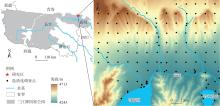
Fig. 1
Geographic location of the study area and spatial distribution of sampling sites"
Tab. 1
Calculation formulas of salinity indices"
| 光谱指数 | 计算公式 | 参考文献 |
|---|---|---|
| 盐分指数(S1) | Blue/Re d | [ |
| 盐分指数(S2) | (Blue-Re d)/(Blue+Re d) | [ |
| 盐分指数(S3) | Green×Re d/Blue | [ |
| 盐分指数(S4) | [ | |
| 盐分指数(S5) | Blue×Re d/Green | [ |
| 盐分指数(S6) | Re d×NIR/Green | [ |
| 盐分指数(S7) | [ | |
| 盐分指数(S8) | (Green+Re d)/2 | [ |
| 盐分指数(S9) | (Green+Re d+NIR)/2 | [ |
| 盐分指数(SI) | [ | |
| 盐分指数(SI_T) | Re d×NIR×100 | [ |
| 盐分指数(SI1) | [ | |
| 盐分指数(SI2) | [ | |
| 盐分指数(SI3) | [ | |
| 盐分指数(SI4) | Swir1/NIR | [ |
| 归一化盐分指数(NDSI) | (Re d-NIR)/(Re d+NIR) | [ |
| 归一化植被指数(NDVI) | (NIR-Re d)/(NIR+Re d) | [ |
| 增强型植被指数(EVI) | [ | |
| 归一化物候指数(NDPI) | [ | |
| 红外植被指数(IPVI) | NIR/(NIR+Re d) | [ |
| 归一化水体指数(NDWI) | (NIR-Swir1)/(NIR+Swir1) | [ |
| 土壤调节植被指数(SAVI) | [ |
Tab. 2
Statistical analysis of measured soil salinity"
| 盐渍化等级 | 分级标准/g·kg-1 | 样本量 | 最小值/g·kg-1 | 最大值/g·kg-1 | 平均值/g·kg-1 | 标准差/g·kg-1 | 变异系数/% |
|---|---|---|---|---|---|---|---|
| 非盐渍化 | <1 | 18 | 0.57 | 0.95 | 0.80 | 0.12 | 15.44 |
| 轻度盐渍化 | 1~2 | 86 | 1.00 | 1.99 | 1.44 | 0.29 | 19.88 |
| 中度盐渍化 | 2~4 | 17 | 2.00 | 3.56 | 2.66 | 0.50 | 18.76 |
| 重度盐渍化 | 4~6 | 4 | 4.30 | 5.56 | 4.90 | 0.56 | 11.46 |
| 盐土 | ≥6 | 4 | 6.01 | 11.65 | 8.07 | 2.51 | 31.12 |
| 所有实测数据 | 129 | 0.57 | 11.65 | 3.57 | 1.45 | 40.61 |

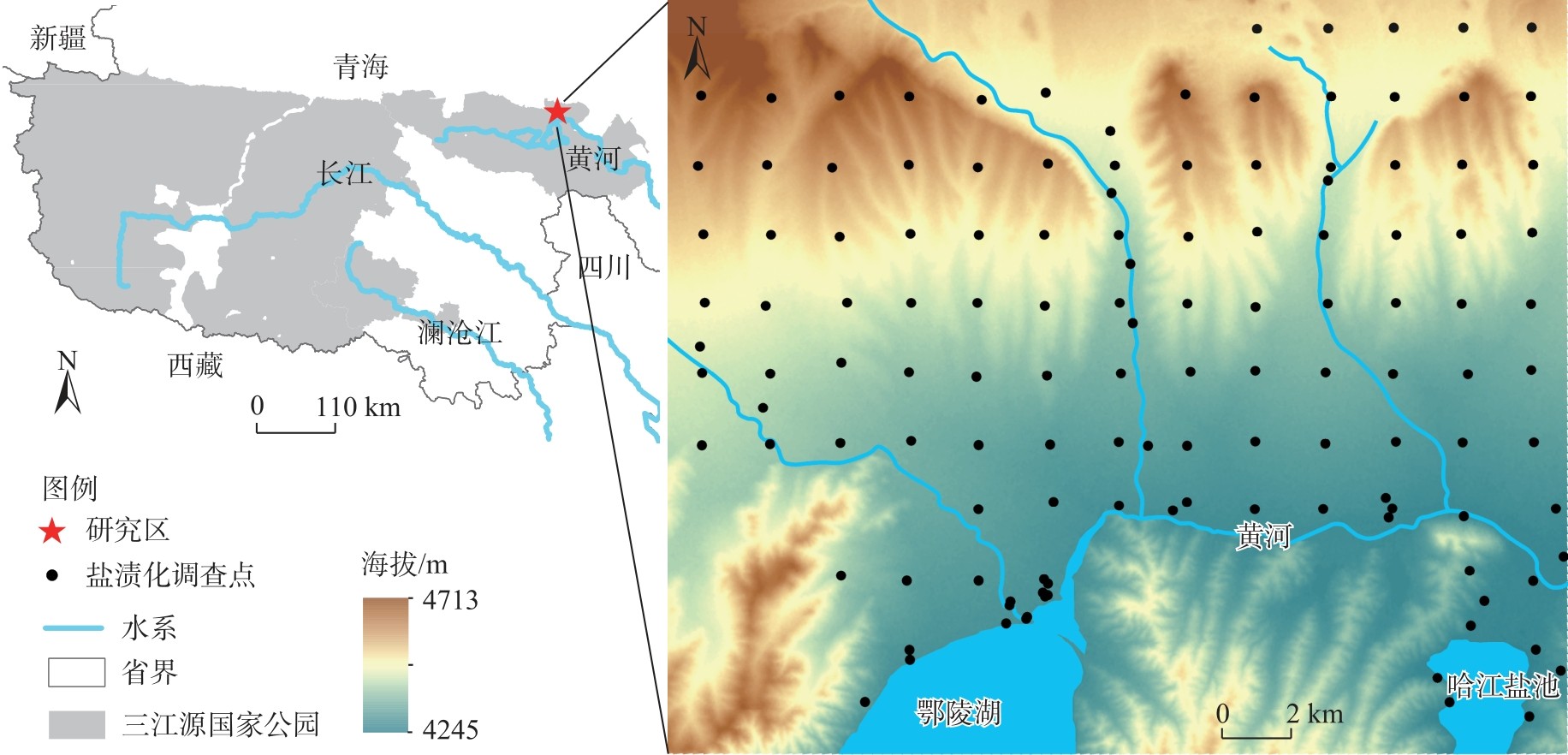
Fig. 2
Comparison of the accuracy of different modeling methods"
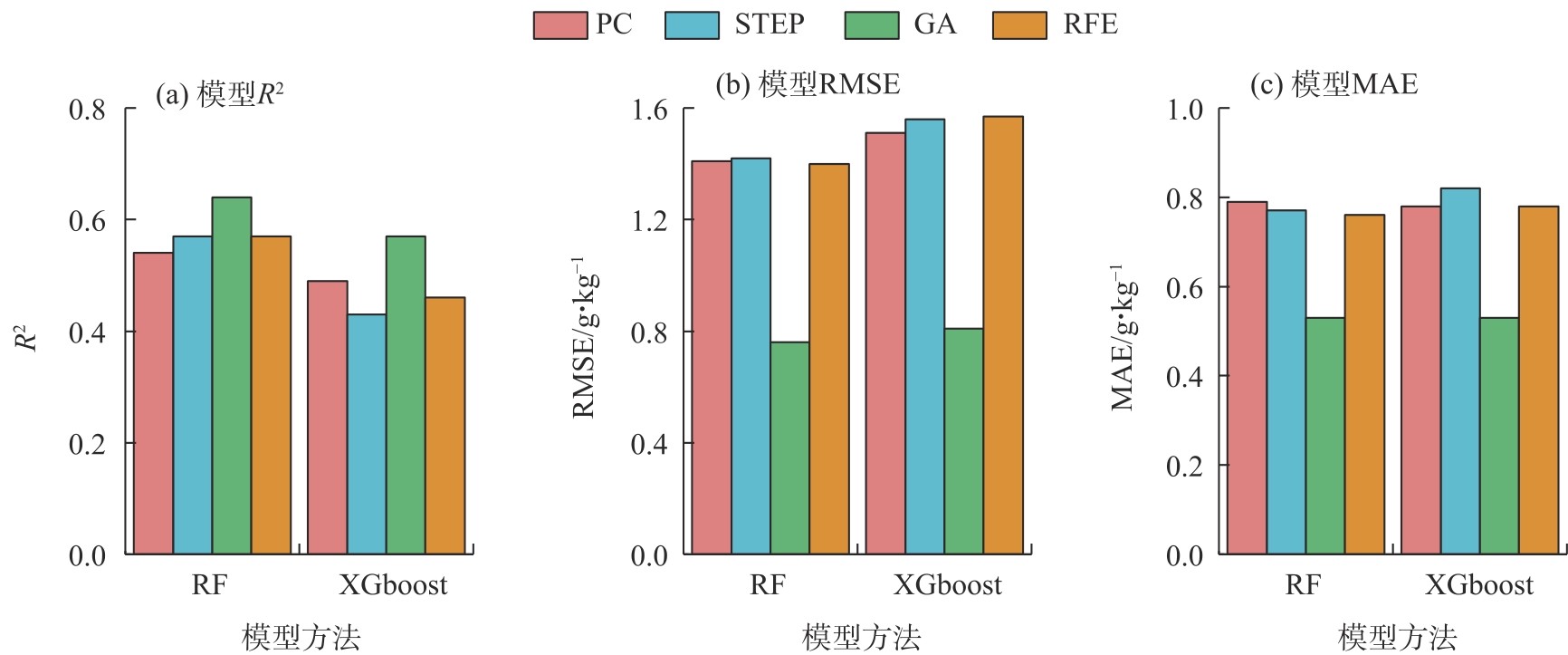
Fig. 3
Model accuracy validation"


Fig. 4
Explanation of SHAP value model"
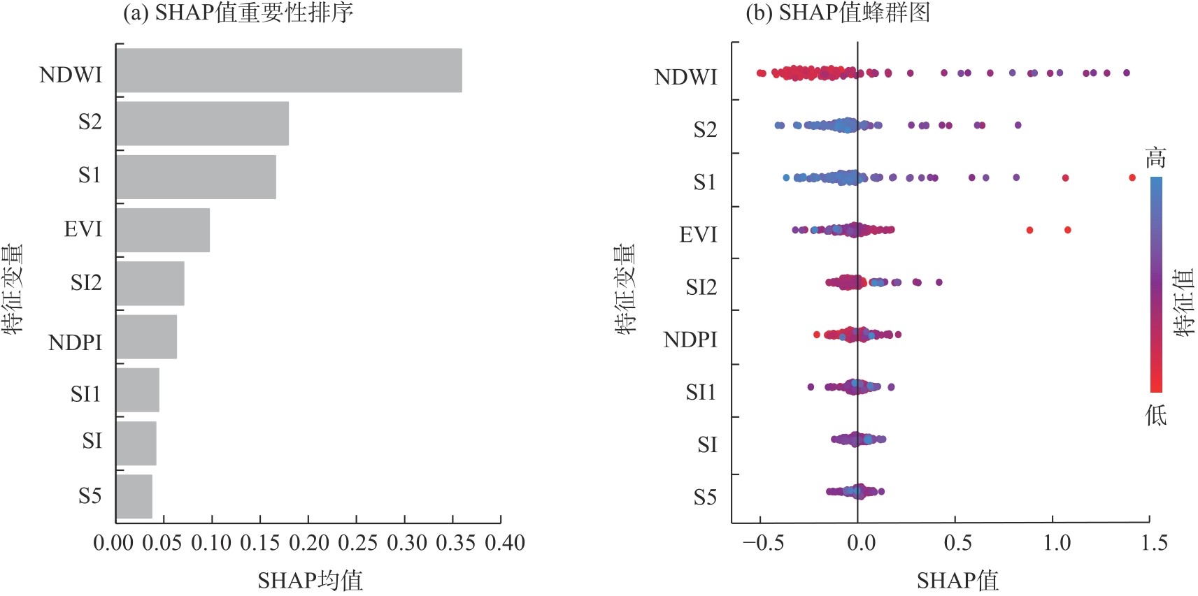
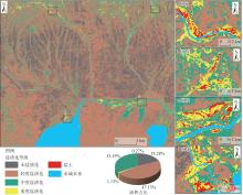
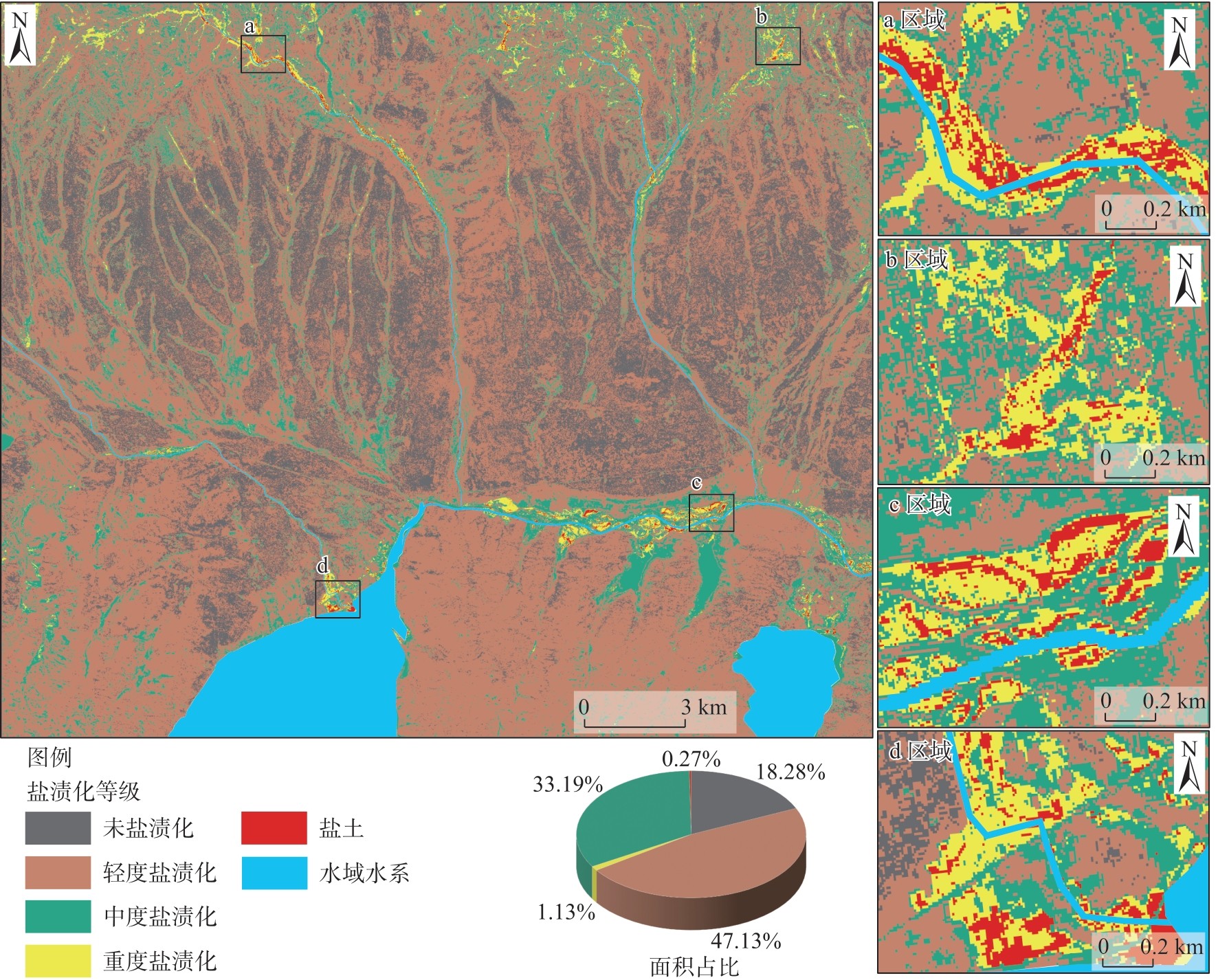
Fig. 5
Spatial distributions of salinity classes"
| [1] |
Butcher K, Wick A F, Desutter T, et al. Soil salinity: A threat to global food security[J]. Agronomy Journal, 2016, 108(6): 2189-2200.
doi: 10.2134/agronj2016.06.0368 |
| [2] | 李建国, 濮励杰, 朱明, 等. 土壤盐渍化研究现状及未来研究热点[J]. 地理学报, 2012, 67(9): 1233-1245. |
| [Li Jianguo, Pu Lijie, Zhu Ming, et al. The present situstion and hot issues in the salt-affected soil research[J]. Acta Geographica Science, 2012, 67(9): 1233-1245.] | |
| [3] | 杨劲松, 姚荣江, 王相平, 等. 中国盐渍土研究: 历程、现状与展望[J]. 土壤学报, 2022, 59(1): 10-27. |
| [Yang Jinsong, Yao Rongjiang, Wang Xiangping, et al. Research on salt-affected soils in China: History, status quo and prospect[J]. Acta Pedologica Science, 2022, 59(1): 10-27.] | |
| [4] |
Li J G, Pu L J, Han M F, et al. Soil salinization research in China: Advances and prospects[J]. Journal of Geographical Sciences, 2014, 24(5): 943-960.
doi: 10.1007/s11442-014-1130-2 |
| [5] | 吴秀泉, 乌兰图雅, 张萨日郎, 等. 中国干旱区草地土壤盐渍化研究可视化分析[J]. 内蒙古师范大学学报(自然科学版), 2024, 53(2): 120-128. |
| [Wu Xiuquan, Ulan Tuya, Zhang Saerilang, et al. Visualization analysis on grassland soil salinization in arid regions of China[J]. Journal of Inner Mongolia Normal University (Natural Science Edition), 2024, 53(2): 120-128.] | |
| [6] |
Cao C Y, Tao S, Cui Z B, et al. Response of soil properties and microbial communities to increasing salinization in the meadow grassland of northeast China[J]. Microbial Ecology, 2021, 82(3): 722-735.
doi: 10.1007/s00248-021-01695-x pmid: 33511437 |
| [7] | Yang L, Zhao G J, Mu X M, et al. Integrated assessments of land degradation on the Qinghai-Xizang Plateau[J]. Ecological Indicators, 2023, 147: 109945, doi: 10.1007/s00248-021-01695-x. |
| [8] | 赵起越, 夏夜, 邹本东. 土壤盐渍化成因危害及恢复[J]. 农业与技术, 2022, 42(11): 115-119. |
| [Zhao Qiyue, Xia Ye, Zou Bendong. Soil salinization causes and hazards and restoration[J]. Agriculture and Technology, 2022, 42(11): 115-119.] | |
| [9] | 陈振宇, 赵禹, 白金, 等. 干旱绿洲区包气带土壤盐分分布特征及运移机制——以新疆焉耆盆地为例[J]. 地质论评, 2024, 70(5): 1857-1872. |
| [Chen Zhenyu, Zhao Yu, Bai Jin, et al. Distribution characteristics and migration mechanism of soil salt in the aeration zone of arid oasis areas: A case study of the Yanqi Basin, Xinjiang[J]. Geological Review, 2024, 70(5): 1857-1872.] | |
| [10] |
Metternicht G I, Zinck J A. Remote sensing of soil salinity: Potentials and constraints[J]. Remote Sensing of Environment, 2003, 85(1): 1-20.
doi: 10.1016/S0034-4257(02)00188-8 |
| [11] | 王敬哲, 丁建丽, 葛翔宇, 等. 基于星地传感技术的土壤盐渍化监测进展与展望[J]. 遥感学报, 2024, 28(9): 2187-2208. |
|
[Wang Jingzhe, Ding Jianli, Ge Xiangyu, et al. Monitoring soil salinization on the basis of remote sensing and proximal soil sensing: Progress and prospective[J]. National Remote Sensing Bulletin, 2024, 28(9): 2187-2208.]
doi: 10.11834/jrs.20233164 |
|
| [12] | Abuelgasim A, Ammad R. Mapping soil salinity in arid and semi-arid regions using Landsat 8 OLI satellite data[J]. Remote Sensing Applications, 2019, 13: 415-425. |
| [13] |
郭佳丽, 马勇刚, 潘恒, 等. 艾比湖春夏季土壤盐渍化卫星监测对比分析[J]. 干旱区地理, 2025, 48(12): 2143-2157.
doi: 10.12118/j.issn.1000-6060.2025.044 |
|
[Guo Jiali, Ma Yonggang, Pan Heng, et al. Comparative analysis of satellite monitoring of soil salinization in Ebinur Lake during spring and summer[J]. Arid Land Geography, 2025, 48(12): 2143-2157.]
doi: 10.12118/j.issn.1000-6060.2025.044 |
|
| [14] | 李星佑, 张飞, 王筝. 土壤盐渍化遥感监测模型构建方法现状与发展趋势[J]. 自然资源遥感, 2022, 34(4): 11-21. |
| [Li Xingyou, Zhang Fei, Wang Zheng. Present situation and development trend in building remote sensing monitoring models of soil salinization[J]. Remote Sensing for Natural Resources, 2022, 34(4): 11-21.] | |
| [15] | 田义超, 郑丹琳, 张强, 等. 基于国产资源一号02D卫星和机器学习算法的钦州湾滨海土壤盐分反演[J]. 中国环境科学, 2024, 44(1): 371-385. |
| [Tian Yichao, Zheng Danlin, Zhang Qiang, et al. Inversion of coastal soil salinity in Qinzhou Bay based on domestic ZY1-02D satellite and machine learning algorithm[J]. China Environmental Science, 2024, 44(1): 371-385.] | |
| [16] | Jia P P, Zhang J H, Liang Y N, et al. The inversion of arid-coastal cultivated soil salinity using explainable machine learning and Sentinel-2[J]. Ecological Indicators, 2024, 166: 112364, doi: 10.1016/j.ecolind.2024.112364. |
| [17] | 王飞, 杨胜天, 丁建丽, 等. 环境敏感变量优选及机器学习算法预测绿洲土壤盐分[J]. 农业工程学报, 2018, 34(22): 102-110. |
| [Wang Fei, Yang Shengtian, Ding Jianli, et al. Environment sensitive variable optimization and machine learning algorithm using in soil salt predictionat oasis[J]. Transactions of the Chinese Society of Agricultural Engineering, 2018, 34(22): 102-110.] | |
| [18] | 巴亚岚, 张智韬, 谢坪良, 等. 集成Sentinel-1/2和环境变量的新疆农田土壤含盐量反演[J]. 农业工程学报, 2024, 40(16): 171-179. |
| [Ba Yalan, Zhang Zhitao, Xie Pingliang, et al. Inverting soil salinity of farmland in Xinjiang by integrating Sentinel-1/2 and environmental variables[J]. Transactions of the Chinese Society of Agricultural Engineering, 2024, 40(16): 171-179.] | |
| [19] | 骆振海, 张超, 冯绍元, 等. 土壤盐渍化光学遥感监测方法研究进展[J]. 自然资源遥感, 2024, 36(4): 9-22. |
| [Luo Zhenhai, Zhang Chao, Feng Shaoyuan, et al. Advances in research on methods for optical remote sensing monitoring of soil salinization[J]. Remote Sensing for Natural Resources, 2024, 36(4): 9-22.] | |
| [20] | 张佘淑, 赵军. 机器学习在土壤盐渍化遥感中应用的文献计量分析[J]. 草业科学, 2023, 40(11): 2812-2821. |
| [Zhang Sheshu, Zhao Jun. Bibliometric analysis of machine learning applications in remote sensing of soil salinization[J]. Pratacultural Science, 2023, 40(11): 2812-2821.] | |
| [21] | Ponce B A V, Schmitt V, Maier C S, et al. Practical guide to SHAP analysis: Explaining supervised machine learning model predictions in drug development[J]. Clinical and Translational Science, 2024, 17(11): e70056, doi: 10.1111/cts.70056. |
| [22] | Wang F, Liang R L, Li S Y, et al. Assessing the impact of multi-source environmental variables on soil organic carbon in different land use types of China using an interpretable high-precision machine learning method[J]. Ecological Indicators, 2024, 169: 112865, doi: 10.1016/j.ecolind.2024.112865. |
| [23] | Li X H, Chen J J, Chen Z Z, et al. Explainable machine learning-based fractional vegetation cover inversion and performance optimization: A case study of an alpine grassland on the Qinghai-Tibet Plateau[J]. Ecological Informatics, 2024, 82: 102768, doi: 10.1016/j.ecoinf.2024.102768. |
| [24] | 尚天浩, 陈睿华, 贾萍萍, 等. 基于多源光谱遥感估算银北地区土壤可溶性盐基氯离子含量[J]. 生态学杂志, 2024, 44(4): 1161-1169. |
| [Shang Tianhao, Chen Ruihua, Jia Pingping, et al. Estimation of soil soluble salt-based Cl-content in northern Ningxia, China based on multi-source spectral remote sensing[J]. Chinese Journal of Ecology, 2024, 44(4): 1161-1169.] | |
| [25] |
高怡婷, 罗栋梁, 陈方方, 等. 黄河源头区地面热状态及冻融特征[J]. 地理学报, 2023, 78(3): 604-619.
doi: 10.11821/dlxb202303007 |
|
[Gao Yiting, Luo Dongliang, Chen Fangfang, et al. Characteristics of the thermal regime and freeze-thaw cycles on the ground surface in permafros regions in the headwater area of the Yellow River[J]. Acta Geographica Sinica, 2023, 78(3): 604-619.]
doi: 10.11821/dlxb202303007 |
|
| [26] |
谢俊博, 王兴鹏, 何帅, 等. 基于光谱指数建模的沙井子灌区土壤盐分反演[J]. 干旱区地理, 2024, 47(7): 1199-1209.
doi: 10.12118/j.issn.1000-6060.2023.584 |
|
[Xie Junbo, Wang Xingpeng, He Shuai, et al. Soil salinity inversion in the Shajingzi irrigation district based on spectral index modeling[J]. Arid Land Geography, 2024, 47(7): 1199-1209.]
doi: 10.12118/j.issn.1000-6060.2023.584 |
|
| [27] |
杨练兵, 陈春波, 郑宏伟, 等. 基于优化随机森林回归模型的土壤盐渍化反演[J]. 地球信息科学学报, 2021, 23(9): 1662-1674.
doi: 10.12082/dqxxkx.2021.200711 |
| [Yang Lianbing, Chen Chunbo, Zheng Hongwei, et al. Retrieval of soil salinity content based on random forests regression optimized by Bayesian optimization algorithm and gentic algorithm[J]. Journal of Geo-Information Science, 2021, 23(9): 1662-1674.] | |
| [28] | 谢志英, 朱文泉, 付永硕. 植被物候遥感监测关键问题[J]. 遥感学报, 2024, 28(9): 2131-2143. |
|
[Xie Zhiying, Zhu Wenquan, Fu Yongshuo. Key issues of remote sensing-based vegetation phenologymonitoring[J]. National Remote Sensing Bulletin, 2024, 28(9): 2131-2143.]
doi: 10.11834/jrs.20233088 |
|
| [29] |
Andersen C M, Bro R. Variable selection in regression: Atutorial[J]. Journal of Chemometrics, 2010, 24(11-12): 728-737.
doi: 10.1002/cem.v24.11/12 |
| [30] |
Duan K B, Rajapakse J C, Wang H, et al. Multiple SVM-RFE for gene selection in cancer classification with expression data[J]. IEEE Transactions on Nanobioscience, 2005, 4(3): 228-234.
doi: 10.1109/TNB.2005.853657 |
| [31] | Smith G. Step away from stepwise[J]. Journal of Big Data, 2018, 5(1): 32, doi: 10.1186/s40537-018-0143-6. |
| [32] |
Bentéjac C, Csörgő A, Martínez-Muñoz G. A comparative analysis of gradient boosting algorithms[J]. Artificial Intelligence Review, 2021, 54(3): 1937-1967.
doi: 10.1007/s10462-020-09896-5 |
| [33] | 黄华雨, 丁启东, 张俊华, 等. 地面高光谱耦合可解释性集成机器学习的农田土壤含盐量和pH反演[J]. 环境科学, 2026, 47(2): 1080-1091. |
| [Huang Huayu, Ding Qidong, Zhang Junhua, et al. Ground-based hyperspectral coupled interpretable integrated machine learning for salinity and pH inversion in agricultural soils[J]. Environment Science, 2026, 47(2): 1080-1091.] | |
| [34] | Ge J, Hou M J, Liang T G, et al. Spatiotemporal dynamics of grassland aboveground biomass and its driving factors in north China over the past 20 years[J]. Science of the Total Environment, 2022, 826: 154226, doi: 10.1016/j.scitotenv.2022.154226. |
| [35] | Yang M X, Chen A, Cao W Q, et al. Spatial and temporal patterns of grassland species diversity and their driving factors in the Three Rivers Headwater region of China from 2000 to 2021[J]. Remote Sensing, 2024, 16(21): 4005, doi: 10.3390/rs16214005. |
| [36] | 李春泽, 张超, 张皓源, 等. 基于XGBoost与地理加权回归的吉林省西部土壤盐渍化反演[J]. 中国农业大学学报, 2024, 29(2): 1-10. |
| [Li Chunze, Zhang Chao, Zhang Haoyuan, et al. Inversion of soil salinization in western Jilin Province based on XGBoost and geographically weighted regression[J]. Journal of China Agricultural University, 2024, 29(2): 1-10.] | |
| [37] | 蒙莉娜, 丁建丽, 王敬哲, 等. 基于环境变量的渭干河-库车河绿洲土壤盐分空间分布[J]. 农业工程学报, 2020, 36(1): 175-181. |
| [Meng Lina, Ding Jianli, Wang Jingzhe, et al. Spatial distribution of soil salinity in Ugan-Kuqa River delta oasis based on environmental variables[J]. Transactions of the Chinese Society of Agricultural Engineering, 2020, 36(1): 175-181.] | |
| [38] | 张永杰, 兰文旭, 蔡和生. 新疆科克苏湿地边缘带土壤水盐和养分含量的空间分布特征[J]. 湿地科学与管理, 2025, 21(2): 10-16. |
| [Zhang Yongjie, Lan Wenxu, Cai Hesheng. The spatial distribution characteristics of soil water, salt, and nutrient content in the marginal zone of the Kokso wetland in Xinjiang[J]. Wetland Science & Management, 2025, 21(2): 10-16.] | |
| [39] | Jiang Z H, Hao Z, Ding J L, et al. Weighted variable optimization-based method for estimating soil salinity using multi-source remote sensing data: A case study in the weiku oasis, Xinjiang, China[J]. Remote Sensing, 2024, 16(17): 3145, doi: 10.3390/rs16173145. |
| [40] | Li Y F, Wang C, Wright A, et al. Combination of GF-2 high spatial resolution imagery and land surface factors for predicting soil salinity of muddy coasts[J]. Catena, 2021, 202: 105304, doi: 10.1016/j.catena.2021.105304. |
| [1] | Nigara TASHPOLAT, MA Yingxuan, Abuduwaili REHEMAN, YANG Lei. Remote sensing inversion of soil salinization in the Weiku Oasis of Xinjiang using Sentinel data and a feature space model [J]. Arid Land Geography, 2026, 49(2): 287-300. |
| [2] | LI Jialin, LI Xinhu, WANG Hongchao, CUI Mengmeng, GUO Yubo, JIN Haodong, REN Xiaoxiao. Quantitative modeling of evaporation resistance in salt crusts under varying influencing factors [J]. Arid Land Geography, 2026, 49(1): 80-93. |
| [3] | GUO Jiali, MA Yonggang, PAN Heng, LI Na, SUN Changning, SUN Qian, ZHOU Wenchang, DANG Yuxuan. Comparative analysis of satellite monitoring of soil salinization in Ebinur Lake during spring and summer [J]. Arid Land Geography, 2025, 48(12): 2143-2157. |
| [4] | GAO Ruixiang, LUO Geping, ZHANG Wenqiang, XIE Mingjuan, WANG Yuangang. Ecosystem carbon flux inversion method combining LSTM and fuzzy mathematics [J]. Arid Land Geography, 2025, 48(12): 2210-2219. |
| [5] | XIN Yue, SU Lijuan, ZHENG Xucheng, LI Hui, YI Nana, JIN Yuchen. Hail characteristics and hail recognition method based on machine learning in Inner Mongolia [J]. Arid Land Geography, 2025, 48(1): 11-19. |
| [6] | MENG Huimin, ZHAN Chesheng, HU Shi, LIN Zhonghui. Research progress on simulation of soil water-salt transport in large-scale irrigation districts [J]. Arid Land Geography, 2024, 47(9): 1566-1576. |
| [7] | XIE Junbo, WANG Xingpeng, HE Shuai, LIU Yang, ZHONG Zhibo, LI Yan, HONG Guojun. Soil salinity inversion in the Shajingzi irrigation district based on spectral index modeling [J]. Arid Land Geography, 2024, 47(7): 1199-1209. |
| [8] | LIU Ruiliang, JIA Keli, LI Xiaoyu, CHEN Ruihua, WANG Yijing, ZHANG Junhua. Inversion of soil salt content by combining optical and microwave remote sensing in cultivated land [J]. Arid Land Geography, 2024, 47(3): 433-444. |
| [9] | LI Ke, DING Jianli, HAN Lijing, GE Xiangyu, GU Yongsheng, ZHOU Qian, LYU Yangxia. Digital mapping of soil salinization in a typical oasis based on PlanetScope images [J]. Arid Land Geography, 2023, 46(8): 1291-1302. |
| [10] | SHI Cong, CHEN Lihan, ZHANG Yifei, HE Shuai, XIE Haixia. Soil salinization characteristics of cultivated land in Xiaohaizi Irrigation Area of Xinjiang [J]. Arid Land Geography, 2023, 46(8): 1314-1323. |
| [11] | CUI Jintao, Mamat SAWUT. Estimation of leaf water content in upland cotton based on feature band selection and machine learning [J]. Arid Land Geography, 2023, 46(11): 1836-1847. |
| [12] | JIANG Lei, LIU Xiaolong, GUO Shuai, HE Liang, XING Jianlei, GUO Junjie. Evaluation of soil salinization susceptibility based on Logistic regression analysis: A case of Tarim irrigation area in southern Xinjiang [J]. Arid Land Geography, 2023, 46(11): 1858-1867. |
| [13] | WEI Huimin, JIA Keli, ZHANG Xu, ZHANG Junhua. Prediction of soil salinity based on machine learning and multispectral remote sensing in Yinchuan Plain [J]. Arid Land Geography, 2023, 46(1): 103-114. |
| [14] | ZHAO Shuang,DING Jianli,HAN Lijing,HUANG Shuai,GE Xiangyu. Response analysis and modeling of microwave dielectric properties of typical saline soil in Xinjiang [J]. Arid Land Geography, 2022, 45(5): 1534-1546. |
| [15] | XIE Conghui,WU Shixin,LIN Juan,ZHUANG Qingwei,ZHANG Zihui,HOU Guanyu,LUO Geping. Analysis of cultivated land salinization in Kashgar Oasis based on PSO-PNN model [J]. Arid Land Geography, 2022, 45(5): 1547-1558. |
|
||