Arid Land Geography ›› 2021, Vol. 44 ›› Issue (5): 1240-1249.doi: 10.12118/j.issn.1000–6060.2021.05.05
• Climatology and Hydrology • Previous Articles Next Articles
QIU Dexun1,2( ),MU Xingmin1,2,3,YIN Diansheng4,GAO Peng1,2,3()
Received:2020-09-21
Revised:2021-01-28
Online:2021-09-25
Published:2021-09-22
Contact:
Peng GAO
E-mail:qiudexun97@163.com;gaopeng@ms.iswc.ac.cn
QIU Dexun,MU Xingmin,YIN Diansheng,GAO Peng. Variation characteristics of drought and its relationship with the extreme precipitation in Dali River Basin[J].Arid Land Geography, 2021, 44(5): 1240-1249.
Tab. 1
Drought and flood grades based on the standard precipitation index (SPI)"
| SPI | 旱涝等级 | SPI | 旱涝等级 |
|---|---|---|---|
| -1.0<SPI≤-0.5 | 轻旱 | 0.5≤SPI<1.0 | 轻涝 |
| -1.5<SPI≤-1.0 | 中旱 | 1.0≤SPI<1.5 | 中涝 |
| -2.0<SPI≤-1.5 | 重旱 | 1.5≤SPI<2.0 | 重涝 |
| SPI≤-2.0 | 特旱 | SPI≥2.0 | 特涝 |

Fig. 1
Annual precipitation and its accumulated anomalies in Dali River Basin during 1971—2017"
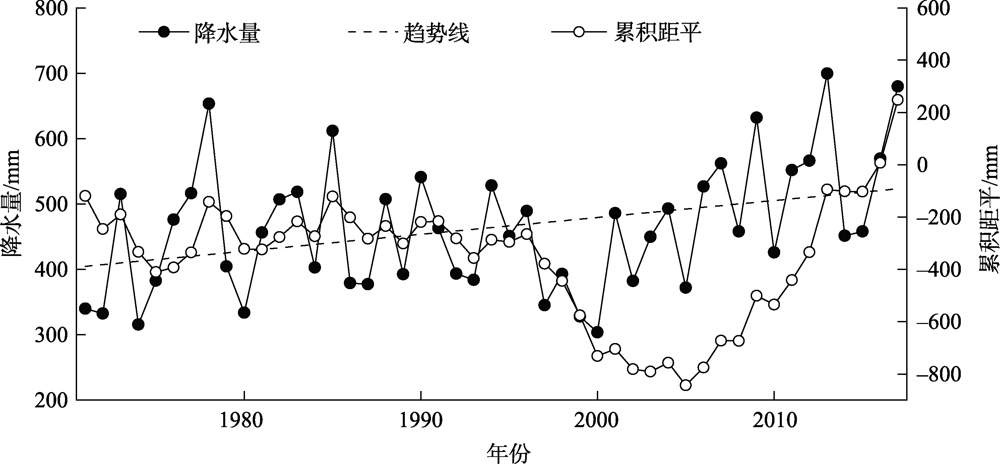
Fig. 2
Distribution of monthly precipitation and its means and M-K detection in Dali River Basin during 1971—2017"

Fig. 3
Evolution of the SPI at different time scales in Dali River Basin during 1971—2017"
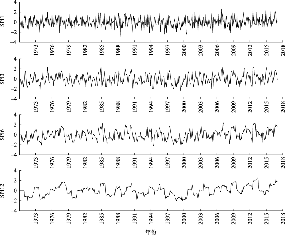

Fig. 4
Temporal variability of SPI3 and SPI12 in Dali River Basin during 1971—2017"


Fig. 5
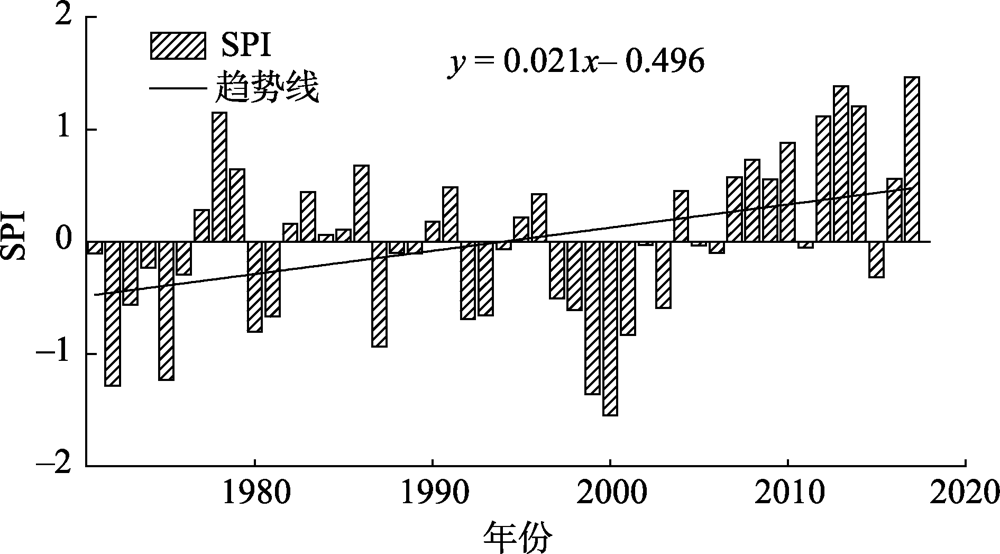
Change of annual SPI in Dali River Basin during 1971—2017"
Tab. 2
Times and frequency statistics of annual and seasonal drought classification"
| 干旱等级 | 春季 | 夏季 | 秋季 | 冬季 | 全年 | |||||||||
|---|---|---|---|---|---|---|---|---|---|---|---|---|---|---|
| 频次/次 | 频率/% | 频次/次 | 频率/% | 频次/次 | 频率/% | 频次/次 | 频率/% | 频次/次 | 频率/% | |||||
| 轻旱 | 8 | 17.0 | 10 | 21.2 | 8 | 17.0 | 5 | 10.6 | 10 | 21.3 | ||||
| 中旱 | 2 | 4.3 | 6 | 12.7 | 8 | 17.0 | 5 | 10.6 | 3 | 6.4 | ||||
| 重旱 | 2 | 4.3 | 1 | 2.1 | 1 | 2.1 | 2 | 4.3 | 1 | 2.1 | ||||
| 特旱 | 1 | 2.1 | 0 | 0 | 0 | 0 | 1 | 2.1 | 0 | 0 | ||||
Tab. 3
Decadal change of annual and seasonal SPI"
| 年代 | SPI | ||||
|---|---|---|---|---|---|
| 春季 | 夏季 | 秋季 | 冬季 | 全年 | |
| 1971—1980年 | -0.30 | -0.18 | -0.29 | 0.31 | -0.24 |
| 1981—1990年 | 0.33 | 0.13 | -0.28 | -0.13 | -0.02 |
| 1991—2000年 | -0.24 | -0.38 | -0.44 | -0.35 | -0.43 |
| 2001—2010年 | 0.08 | 0.04 | 0.32 | 0.33 | 0.16 |
| 2011—2017年 | 0.04 | 0.62 | 0.97 | -0.25 | 0.77 |
| 变化倾向率/(10a)-1 | 0.05 | 0.14 | 0.27 | -0.05 | 0.21 |
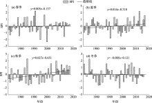
Fig. 6
SPI change in different seasons in Dali River Basin during 1971—2017"

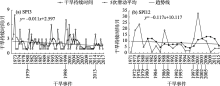
Fig. 7
Change of SPI3 and SPI12 drought events duration in Dali River Basin during 1971—2017"

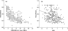
Fig. 8
Relationship between the days of daily precipitation ≥0.1 mm, SPI1 and Rmax/Rtotal at Lijiahe station"

Tab. 4
Relationship between extreme precipitation events and drought"
| 年份 | 最大日降水量/mm | 年SPI | 旱涝等级 |
|---|---|---|---|
| 1972 | 68.9 | -1.286 | 中旱 |
| 1974 | 77.1 | -0.234 | 正常 |
| 1977 | 82.3 | 0.280 | 正常 |
| 1978 | 97.9 | 1.149 | 中涝 |
| 1979 | 77.9 | 0.644 | 轻涝 |
| 1981 | 52.0 | -0.669 | 轻旱 |
| 1982 | 57.0 | 0.156 | 正常 |
| 1984 | 59.9 | 0.057 | 正常 |
| 1988 | 55.3 | -0.101 | 正常 |
| 1989 | 71.2 | -0.106 | 正常 |
| 2006 | 96.6 | -0.101 | 正常 |
| 2009 | 75.8 | 0.554 | 轻涝 |
| 2010 | 66.8 | 0.879 | 轻涝 |
| 2013 | 50.8 | 1.384 | 中涝 |
| 2014 | 54.8 | 1.208 | 中涝 |
| 2017 | 139.0 | 1.465 | 中涝 |
| [1] | 张利利, 周俊菊, 张恒玮, 等. 基于SPI的石羊河流域气候干湿变化及干旱事件的时空格局特征研究[J]. 生态学报, 2017, 37(3):996-1007. |
| [ Zhang Lili, Zhou Junju, Zhang Hengwei, et al. Temporal and spatial patterns of climate drought-wet and drought event based on precipitation index in Shiyang River Basin[J]. Acta Ecologica Sinica, 2017, 37(3):996-1007. ] | |
| [2] | 邹磊, 余江游, 夏军, 等. 基于SPEI的渭河流域干旱时空变化特征分析[J]. 干旱区地理, 2020, 43(2):329-338. |
| [ Zou Lei, Yu Jiangyou, Xia Jun, et al. Temporal-spatial variation characteristics of drought in the Weihe River Basin based on SPEI[J]. Arid Land Geography, 2020, 43(2):329-338. ] | |
| [3] | 胡子瑛, 周俊菊, 张利利, 等. 中国北方气候干湿变化及干旱演变特征[J]. 生态学报, 2018, 38(6):1908-1919. |
| [ Hu Ziying, Zhou Junju, Zhang Lili, et al. Climate dry-wet change and drought evolution characteristics of different dry-wet areas in northern China[J]. Acta Ecologica Sinica, 2018, 38(6):1908-1919. ] | |
| [4] | 黄晚华, 杨晓光, 李茂松, 等. 基于标准化降水指数的中国南方季节性干旱近58 a演变特征[J]. 农业工程学报, 2010, 26(7):50-59. |
| [ Huang Wanhua, Yang Xiaoguang, Li Maosong, et al. Evolution characteristics of seasonal drought in the south of China during the past 58 years based on standardized precipitation index[J]. Transactions of the Chinese Society of Agricultural Engineering, 2010, 26(7):50-59. ] | |
| [5] |
袁文平, 周广胜. 标准化降水指标与Z指数在我国应用的对比分析[J]. 植物生态学报, 2004, 28(4):523-529.
doi: 10.17521/cjpe.2004.0071 |
|
[ Yuan Wenping, Zhou Guangsheng. Comparison between standardized precipitation index and Z-index in China[J]. Acta Phytoecologica Sinica, 2004, 28(4):523-529. ]
doi: 10.17521/cjpe.2004.0071 |
|
| [6] | Tate E L, Gustard A. Drought definition: A hydrological perspective[C]// Vogt J V, Somma F. Drought and Drought Mitigation in Europe. Dordrecht: Kluwer, 2000: 23-48. |
| [7] |
Wilhite D A, Glantz M H. Understanding the drought phenomenon: The role of definition[J]. Water International, 1985, 10:111-120.
doi: 10.1080/02508068508686328 |
| [8] | 翟盘茂, 邹旭恺. 1951-2003年中国气温和降水变化及其对干旱的影响[J]. 气候变化研究进展, 2005, 1(1):16-18. |
| [ Zhai Panmao, Zou Xukai. Changes in temperature and precipitation and their impacts on drought in China during 1951-2003[J]. Advances in Climate Change Research, 2005, 1(1):16-18. ] | |
| [9] | 冯冬蕾, 程志刚, 赵雷, 等. 4种干旱判别指数在东北地区适用性分析[J]. 干旱区地理, 2020, 43(2):371-379. |
| [ Feng Donglei, Cheng Zhigang, Zhao Lei, et al. Applicability analysis of four drought indexes in northeast China[J]. Arid Land Geography, 2020, 43(2):371-379. ] | |
| [10] | 王劲松, 郭江勇, 周跃武, 等. 干旱指标研究的进展与展望[J]. 干旱区地理, 2007, 30(1):61-67. |
| [ Wang Jinsong, Guo Jiangyong, Zhou Yuewu, et al. Progress and prospect on drought indices research[J]. Arid Land Geography, 2007, 30(1):61-67. ] | |
| [11] | 陈莹, 陈兴伟. 福建省近50年旱涝时空特征演变--基于标准化降水指数分析[J]. 自然灾害学报, 2011, 20(3):57-63. |
| [ Chen Ying, Chen Xingwei. Evolution of spatiotemporal characteristics of flood and drought in Fujan Province for recent 50 years: An SPI-based analysis[J]. Journal of Natural Disasters, 2011, 20(3):57-63. ] | |
| [12] | 蔡哲, 章毅之, 何拥凤, 等. 江西省干旱洪涝的时空变化特征分析[J]. 自然灾害学报, 2013, 22(2):144-149. |
| [ Cai Zhe, Zhang Yizhi, He Yongfeng, et al. Analysis of spatiotemporal trend characteristics of droughts and floods in Jiangxi Province[J]. Journal of Natural Disasters, 2013, 22(2):144-149. ] | |
| [13] | GB/T 20481-2006. 中华人民共和国标准: 气象干旱等级 北京: 中国标准出版社, 2006. |
| [GB/T 20481-2006. National standard of the People’s Republic of China: Grades of meteorological drought[S]. Beijing: Standards Press of China, 2006. ] | |
| [14] | McKee T B, Doesken N J, Kleist J. The relationship of drought frequency and duration of time scales[C]// Eighth Conference on Applied Climatology. Anaheim CA: American Meteorological Society, 1993: 179-186. |
| [15] |
Seiler R A, Hayes M, Bressan L. Using the standardized precipitation index for flood risk monitoring[J]. International Journal of Climatology, 2002, 22(11):1365-1376.
doi: 10.1002/(ISSN)1097-0088 |
| [16] | 翟禄新, 冯起. 基于SPI的西北地区气候干湿变化[J]. 自然资源学报, 2011, 26(5):847-857. |
| [ Zhai Luxin, Feng Qi. Dryness/wetness climate variation based on standardized precipitation index in northwest China[J]. Journal of Natural Resources, 2011, 26(5):847-857. ] | |
| [17] | 刘可晶, 王文, 朱烨, 等. 淮河流域过去60年干旱趋势特征及其与极端降水的联系[J]. 水利学报, 2012, 43(10):1179-1187. |
| [ Liu Kejing, Wang Wen, Zhu Ye, et al. Trend of drought and its relationship with extreme precipitation in Huaihe River Basin over the last 60 years[J]. Journal of Hydraulic Engineering, 2012, 43(10):1179-1187. ] | |
| [18] | 陶新娥, 陈华, 许崇育, 等. 基于SPI/SPEI指数的汉江流域1961-2014年干旱变化特征分析[J]. 水资源研究, 2015, 4(5):404-415. |
| [ Tao Xin’e, Chen Hua, Xu Chongyu, et al. Characteristics of drought variations in Hanjiang Basin in 1961-2014 based on SPI/SPEI[J]. Journal of Water Resources Research, 2015, 4(5):404-415. ] | |
| [19] | 王跃峰, 陈兴伟, 陈莹. 基于多时间尺度SPI的闽江流域干湿变化与洪旱事件识别[J]. 山地学报, 2014, 32(1):52-57. |
| [ Wang Yuefeng, Chen Xingwei, Chen Ying. Based on multiple time scales of SPI dry/wet conditions variation and identification of flood and drought events in Minjiang River of Fujian[J]. Mountain Research, 2014, 32(1):52-57. ] | |
| [20] | 黄生志, 黄强, 王义民, 等. 基于SPI的渭河流域干旱特征演变研究[J]. 自然灾害学报, 2015, 24(1):15-22. |
| [ Huang Shengzhi, Huang Qiang, Wang Yimin, et al. Evolution of drought characteristics in the Weihe River Basin based on standardized precipitation index[J]. Journal of Natural Disasters, 2015, 24(1):15-22. ] | |
| [21] | 叶柏松, 赵成义, 姜逢清, 等. 近300 a来塔里木河流域旱涝灾害特征分析[J]. 冰川冻土, 2014, 36(1):173-182. |
| [ Ye Baisong, Zhao Chengyi, Jiang Fengqing, et al. Characteristics of the flood and drought disasters in the Tarim River Basin in recent 300 years[J]. Journal of Glaciology and Geocryology, 2014, 36(1):173-182. ] | |
| [22] |
Gruza G, Rankova E, Razuvaev V, et al. Indicators of climate change for the Russian federation[J]. Climatic Change, 1999, 42(1):219-242.
doi: 10.1023/A:1005480719118 |
| [23] |
Vicente-Serrano S M, Cuadrat J M. Trends in drought intensity and variability in the middle Ebro valley (NE Spain) during the second half of the twentieth century[J]. Theoretical and Applied Climatology, 2007, 88:247-258.
doi: 10.1007/s00704-006-0236-6 |
| [24] | 于家瑞, 艾萍, 袁定波, 等. 基于SPI的黑龙江省干旱时空特征分析[J]. 干旱区地理, 2019, 42(5):1059-1068. |
| [ Yu Jiarui, Ai Ping, Yuan Dingbo, et al. Spatial-temporal characteristics of drought in Heilongjiang Province based on standardized precipitation index[J]. Arid Land Geography, 2019, 42(5):1059-1068. ] | |
| [25] |
肖名忠, 张强, 陈小宏. 基于多变量概率分析的珠江流域干旱特征研究[J]. 地理学报, 2012, 67(1):83-92.
doi: 10.11821/xb201201009 |
|
[ Xiao Mingzhong, Zhang Qiang, Chen Xiaohong. Spatial-temporal patterns of drought risk across the Pearl River Basin[J]. Acta Geographica Sinica, 2012, 67(1):83-92. ]
doi: 10.11821/xb201201009 |
|
| [26] | 葛彩莲, 蔡焕杰, 康艳. 无定河流域气象干旱计算与分析[C]// 中国农业工程学会农业水土工程专业委员会,云南农业大学水利水电与建筑学院. 现代节水高效农业与生态灌区建设(下). 昆明: 云南大学出版社, 2010: 138-146. |
| [ Ge Cailian, Cai Huanjie, Kang Yan. Calculation and analysis of meteorological drought in the Wuding River[C]// Agricultural Soil and Water Engineering Specialized Committee, Chinese Society of Agricultural Engineering, College of Water Conservancy, Hydropower and Architecture, Yunnan Agricultural University. Modern Water-saving and Efficient Agriculture and Construction of Ecological Irrigated Areas. Kunming: Yunnan University Press, 2010: 138-146. ] | |
| [27] | 王文亚. 变化环境下无定河流域水文干旱演变规律及驱动机制分析[D]. 杨陵: 西北农林科技大学, 2017. |
| [ Wang Wenya. Evolution and driving mechanism of hydrologic drought in Wuding River Basin under changing environment[D]. Yangling: Northwest A & F University, 2017. ] | |
| [28] | 孙智辉, 王治亮, 曹雪梅, 等. 基于标准化降水指数的陕西黄土高原地区1971-2010年干旱变化特征[J]. 中国沙漠, 2013, 33(5):1560-1567. |
| [ Sun Zhihui, Wang Zhiliang, Cao Xuemei, et al. Characteristics of drought change in the Loess Plateau area of Shaanxi based on the standardized precipitation index during 1971-2010[J]. Journal of Desert Research, 2013, 33(5):1560-1567. ] | |
| [29] | 史尚渝. 黄土高原气象干旱时空变化及其对植被的影响[D]. 北京: 中国科学院大学(中国科学院教育部水土保持与生态环境研究中心), 2019. |
| [ Shi Shangyu. Temporal and spatial variation of meteorological drought and vegetation vulnerability to drought on Loess Plateau[D]. Beijing: University of Chinese Academy of Sciences(Research Centre of Soil and Water Conservation & Eco-environment, CAS, EM), 2019. ] | |
| [30] |
叶正伟. 基于SPI的江苏沿海开发地区旱涝演变特征分析--以盐城市为例[J]. 地理科学, 2014, 34(4):479-487.
doi: 10.13249/j.cnki.sgs.2014.04.479 |
|
[ Ye Zhengwei. Flood and drought change based SPI analysis in the developing coastal region of Jiangsu Province: A case study in Yancheng City[J]. Scientia Geographica Sinica, 2014, 34(4):479-487. ]
doi: 10.13249/j.cnki.sgs.2014.04.479 |
| [1] | LIU Wenli, CHEN Zhang, ZHAO Yong, LIANG Yuxin. Influences of soil moisture anomalies in May on June precipitation in Central Asia [J]. Arid Land Geography, 2024, 47(1): 38-47. |
| [2] | SHI Weiliang, CHE Luyang, LI Tao. Probability distribution and comprehensive risk assessment of extreme precipitation in flood season in Shaanxi Province [J]. Arid Land Geography, 2023, 46(9): 1407-1417. |
| [3] | NIU Yiying, LI Chunlan, WANG Jun, XU Hanqing, LIU Qing. Performance evaluation of ERA5 reanalysis precipitation data and spatiotemporal characteristics of extreme precipitation in Inner Mongolia [J]. Arid Land Geography, 2023, 46(9): 1418-1431. |
| [4] | LU Dongyan, ZHU Xiufang, LIU Tingting, ZHANG Shizhe. Changes in meteorological drought characteristics in China under the 2 ℃ temperature rise scenario [J]. Arid Land Geography, 2023, 46(8): 1227-1237. |
| [5] | HUANG Xin, JIAO Li, MA Xiaofei, WANG Yonghui, Aerman ABULA. Change characteristics of extreme precipitation events in Central Asia in recent 60 years based on RClimDex model [J]. Arid Land Geography, 2023, 46(7): 1039-1051. |
| [6] | BAI He, MING Yisen, LIU Qihang, HUANG Chang. Downscaling of GPM satellite precipitation data in the Yellow River Basin based on MGWR model [J]. Arid Land Geography, 2023, 46(7): 1052-1062. |
| [7] | CHENG Shuo, LI Yanzhong, XING Yincong, YU Zhiguo, WANG Yuangang, HUANG Manjie. Simulation performance of remote sensing precipitation products on hydrological drought characteristics in the source region of the Yellow River [J]. Arid Land Geography, 2023, 46(7): 1063-1072. |
| [8] | SHI Jiqing, GAN Chenlong, ZHOU Kanshe, YUAN Lei, ZHANG Dongdong. Spatiotemporal distribution of drought and hazard assessment of highland barley in Tibet [J]. Arid Land Geography, 2023, 46(7): 1098-1110. |
| [9] | WANG Jianian, LI Xiangyi, LI Chengdao, ZHANG Ailin, LIN Lisha. Decomposition characteristics of two desert plant leaf under natural light and shade environment [J]. Arid Land Geography, 2023, 46(6): 949-957. |
| [10] | QIU Huimin, WAN Yu, ZHANG Shiming, XIAO Lianyuan, ZHOU Xueying, WEN Chun, JIANG Jujin. Meteorological factor characteristic and index of precipitation types during winter half year in northern Bayingol Prefecture of Xinjiang [J]. Arid Land Geography, 2023, 46(4): 563-573. |
| [11] | REN Taotao,LI Shuangshuang,DUAN Keqin,HE Jinping. Spatiotemporal variation characteristics and influencing factors of heat wave and precipitation deficit flash drought in the Loess Plateau [J]. Arid Land Geography, 2023, 46(3): 360-370. |
| [12] | XU Xintong,ZHU Li,LYU Xiaoyu,GUO Hao. Applicability evaluation of MSWEP product for meteorological drought monitoring in the Yellow River Basin [J]. Arid Land Geography, 2023, 46(3): 371-384. |
| [13] | SUN Nansha,CHEN Qiong,LIU Fenggui,ZHOU Qiang,GUO Yuanyuan. Agricultural drought research in Yellow River-Huangshui River Valley from 2000 to 2020 [J]. Arid Land Geography, 2023, 46(3): 437-447. |
| [14] | DIAO Peng,LI Gang,YUAN Xianlei,WEN Chun. Effect of artificial precipitation enhancement in Bayanbulak mountain area in warm seasons based on Budyko model [J]. Arid Land Geography, 2023, 46(12): 1963-1972. |
| [15] | CAO Yujuan, SI Wenyang, DU Ziqiang, LIANG Hanxue, LEI Tianjie, SUN Bin, WU Zhitao. Changes in GPP of China during the typical drought years from 1982 to 2017 [J]. Arid Land Geography, 2023, 46(10): 1577-1590. |
|
||