- May. 8, 2025
Arid Land Geography ›› 2021, Vol. 44 ›› Issue (1): 277-288.doi: 10.12118/j.issn.1000–6060.2021.01.29
• Regional Development • Previous Articles Next Articles
LI Lu1( ),SUN Guili1,2(),LU Haiyan1,LU Hang1,SHI Haobo1
Received:2019-08-12
Revised:2020-08-27
Online:2021-01-25
Published:2021-03-09
Contact:
Guili SUN
E-mail:1459595140@qq.com;sxfgl@126.com
LI Lu,SUN Guili,LU Haiyan,LU Hang,SHI Haobo. Spatial-temporal variation and driving forces of ecological vulnerability in Kashi Prefecture[J].Arid Land Geography, 2021, 44(1): 277-288.
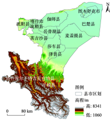
Fig. 1
Indicative compartment of counties in Kashi Prefecture"

Tab. 1
Evaluation index system of ecological vulnerability in Kashi Prefecture"
| 目标 | 框架 | 因子 | 指标 |
|---|---|---|---|
| 喀什地区生态脆弱性 | 暴露程度 | 人为干扰 | 人口密度 |
| 牲畜头数 | |||
| 耕地面积 | |||
| 景观破碎度指数 | |||
| 敏感性 | 地形状况 | 地形起伏度 | |
| 坡度 | |||
| 植被状况 | 植被覆盖度 | ||
| 气候条件 | 年均降水量 | ||
| 年均气温 | |||
| 恢复适应力 | 环境因素 | 生境质量指数 | |
| ≥10 ℃积温 | |||
| 景观恢复性指数 | |||
| 经济指标 | 人均GDP |
Tab. 2
Results of the first seven principal components analysis in Kashi Prefecture in 2000 and 2016"
| 主成分 | 2000年 | 2016年 | |||||
|---|---|---|---|---|---|---|---|
| 特征值(λ) | 贡献率/% | 累计贡献率/% | 特征值(λ) | 贡献率/% | 累计贡献率 /% | ||
| 1 | 0.110 | 50.661 | 50.661 | 0.120 | 49.180 | 49.180 | |
| 2 | 0.053 | 24.732 | 75.393 | 0.053 | 21.842 | 71.022 | |
| 3 | 0.021 | 9.793 | 85.186 | 0.028 | 11.470 | 82.493 | |
| 4 | 0.009 | 4.453 | 89.640 | 0.014 | 5.916 | 88.410 | |
| 5 | 0.009 | 4.231 | 93.872 | 0.013 | 5.574 | 93.985 | |
| 6 | 0.006 | 2.829 | 96.701 | 0.007 | 2.886 | 96.871 | |
| 7 | 0.005 | 2.336 | 99.038 | 0.005 | 2.102 | 98.973 | |

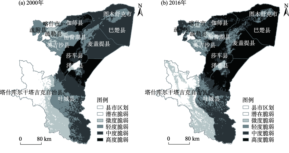
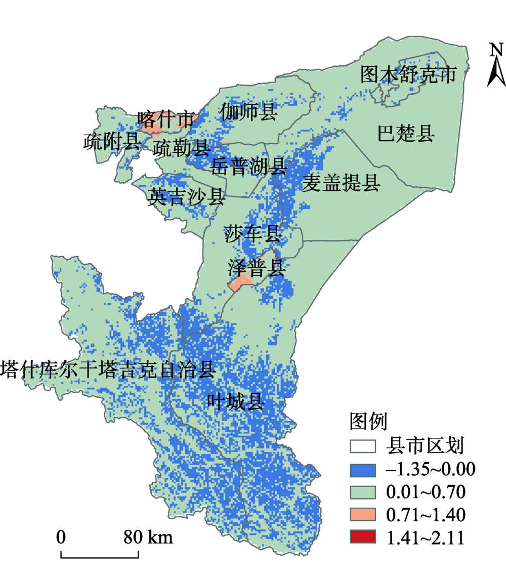
Fig. 2
Distribution of ecological vulnerability level in Kashi Prefecture"
Tab. 3
Change of vulnerability areas of different grades in Kashi Prefecture in recent 17 a"
| 脆弱性等级 | 2000年 | 2016年 | 变化比例/% | |||
|---|---|---|---|---|---|---|
| 面积/km2 | 占总面积比/% | 面积/km2 | 占总面积比例/% | |||
| 潜在脆弱区 | 14995.25 | 13.17 | 12464.56 | 10.94 | -2.23 | |
| 微度脆弱区 | 13141.51 | 11.54 | 13912.92 | 12.22 | +0.68 | |
| 轻度脆弱区 | 24999.98 | 21.95 | 14936.23 | 13.12 | -8.83 | |
| 中度脆弱区 | 47870.73 | 42.04 | 29301.77 | 25.73 | -16.31 | |
| 高度脆弱区 | 12866.02 | 11.30 | 43258.01 | 37.99 | +26.69 | |
Tab. 4
Analysis of the mutual transformation of vulnerable areas in Kashi Prefecture /km2"
| 年份 | 脆弱区等级 | 2016年 | ||||
|---|---|---|---|---|---|---|
| 潜在脆弱区 | 微度脆弱区 | 轻度脆弱区 | 中度脆弱区 | 高度脆弱区 | ||
| 2000年 | 潜在脆弱区 | 10658.06 | 4002.67 | 271.56 | 51.16 | 11.8 |
| 微度脆弱区 | 1782.90 | 9217.57 | 2007.24 | 94.45 | 39.35 | |
| 轻度脆弱区 | 19.67 | 657.27 | 11563.29 | 12059.19 | 700.56 | |
| 中度脆弱区 | 3.93 | 19.67 | 1039.04 | 16542.03 | 30266.06 | |
| 高度脆弱区 | 0.0 | 15.74 | 55.1 | 554.94 | 12240.24 | |
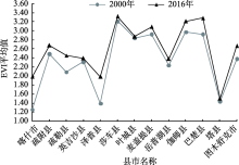
Fig. 3
Average ecological vulnerability index of counties and cities in 2000 and 2016"

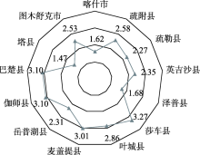
Fig. 4
Average ecological vulnerability index of counties and cities in Kashi Prefecture over the years"
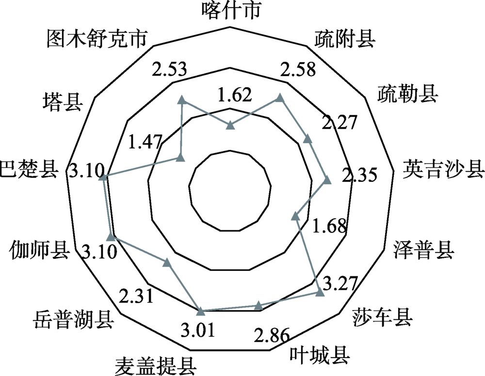

Fig. 5
Distribution of ecological vulnerability index in Kashi Prefecture from 2000 to 2016"
Tab. 5
Interaction between key indicators"
| 交互类型 | q值 | 交互类型 | q值 |
|---|---|---|---|
| 生境质量指数∩植被覆盖度 | 0.196 | 牲畜头数∩植被覆盖度 | 0.200 |
| 生境质量指数∩年均气温 | 0.331 | 牲畜头数∩年均气温 | 0.274 |
| 生境质量指数∩景观恢复性 | 0.234 | 牲畜头数∩人口密度 | 0.191 |
| 耕地面积∩植被覆盖度 | 0.207 | 牲畜头数∩人均GDP | 0.176 |
| 耕地面积∩年均气温 | 0.300 | 植被覆盖度∩年均降水量 | 0.213 |
| 耕地面积∩人口密度 | 0.205 | 植被覆盖度∩年均气温 | 0.116 |
| 耕地面积∩景观恢复性 | 0.256 | 植被覆盖度∩景观恢复性 | 0.085 |
| 耕地面积∩人均GDP | 0.178 | 植被覆盖度∩人口密度 | 0.016 |
| 景观破碎度∩植被覆盖度 | 0.263 | 植被覆盖度∩地形起伏度 | 0.199 |
| 景观破碎度∩年均气温 | 0.362 | 植被覆盖度∩10 ℃以上积温 | 0.164 |
| 年均降水量∩年均气温 | 0.301 | 植被覆盖度∩坡度 | 0.215 |
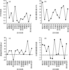
Fig. 6
Changes of ecological vulnerability index, number of livestock, cultivated land area and habitat quality index in each cities"

| [1] | 徐君, 李贵芳, 王育红. 生态脆弱性国内外研究综述与展望[J]. 华东经济管理, 2016,30(4):149-162. |
| [ Xu Jun, Li Guifang, Wang Yuhong. Review and prospect of domestic and foreign research on ecological vulnerability[J]. East China Economic Management, 2016,30(4):149-162. ] | |
| [2] |
Moertberg U M, Balfors B, Knol W C. Landscape ecological assessment: A tool for integrating biodiversity issues in strategic environmental assessment and planning[J]. Journal of Environmental Management, 2007,82(4):457-470. ]
doi: 10.1016/j.jenvman.2006.01.005 |
| [3] | 周苏娥, 张明军, 王圣杰, 等. 甘肃省河西地区自然-社会系统脆弱性评价[J]. 资源科学, 2018,40(2):452-462. |
| [ Zhou Su’e, Zhang Mingjun, Wang Shengjie, et al. Vulnerability assessment of natural-social system in Hexi region of Gansu Province[J]. Resource Science, 2018,40(2):452-462. ] | |
| [4] | 颜磊, 许学工, 谢正磊, 等. 北京市域生态敏感性综合评价[J]. 生态学报, 2009,29(6):3117-3125. |
| [ Yan Lei, Xu Xuegong, Xie Zhenglei, et al. Comprehensive evaluation of regional ecological sensitivity in Beijing[J]. Journal of Ecology, 2009,29(6):3117-3125. ] | |
| [5] | 潘峰, 田长彦, 邵峰, 等. 新疆克拉玛依市生态敏感性研究[J]. 地理学报, 2011,66(11):1497-1507. |
| [ Pan Feng, Tian Changyan, Shao Feng, et al. Study on ecological sensitivity of Karamay City in Xinjiang[J]. Acta Geographica Sinica, 2011,66(11):1497-1507. ] | |
| [6] | 刘萍, 李园园. 基于RS和GIS的乌鲁木齐市城市绿地景观评价研究[J]. 华南农业大学学报, 2007,28(4):56-59. |
| [ Liu Ping, Li Yuanyuan. Research on urban greenbelt landscape evaluation of Urumqi City based on RS and GIS[J]. Journal of South China Agricultural University, 2007,28(4):56-59. ] | |
| [7] | 王钰, 胡宝清. 西江流域生态脆弱性时空分异及其驱动机制研究[J]. 地球信息科学学报, 2018,20(7):947-956. |
| [ Wang Yu, Hu Baoqing. Spatial and temporal differentiation of ecological vulnerability of Xijiang River in Guangxi and its driving mechanism based on GIS[J]. Journal of Geo-information Science, 2018,20(7):947-956. ] | |
| [8] | 王一航, 夏沛, 刘志锋, 等. 中国绿洲城市土地利用/覆盖变化研究进展[J]. 干旱区地理, 2019,42(2):341-353. |
| [ Wang Yihang, Xia Pei, Liu Zhifeng, et al. Research progress of land use/cover change in oasis cities in China[J]. Arid Land Geography, 2019,42(2):341-353. ] | |
| [9] | 黄莹, 包安明, 刘海隆, 等. 基于景观格局的新疆生态脆弱性综合评价研究[J]. 干旱地区农业研究, 2009,27(3):261-266. |
| [ Huang Ying, Bao Anming, Liu Hailong, et al. Comprehensive evaluation of ecological vulnerability in Xinjiang based on landscape pattern[J]. Agricultural Research in the Arid Areas, 2009,27(3):261-266. ] | |
| [10] | 林金煌, 胡国建, 祁新华, 等. 闽三角城市群生态环境脆弱性及其驱动力[J]. 生态学报, 2018,38(12):4155-4166. |
| [ Lin Jinhuang, Hu Guojian, Qi Xinhua, et al. Ecological environmental vulnerability and its driving forces in urban agglomeration in the Fujian delta region[J]. Acta Ecologica Sinica, 2018,38(12):4155-4166. ] | |
| [11] | 熊杰, 曾源, 朱亮, 等. 近25年三峡库区土地覆被变化及驱动力分析[J]. 长江流域资源与环境, 2018,27(10):2368-2378. |
| [ Xiong Jie, Zeng Yuan, Zhu Liang, et al. Analysis of land cover change and driving force in the Three Gorges Reservoir Area in the past 25 years[J]. Resources and Environment in the Yangtze Basin, 2018,27(10):2368-2378. ] | |
| [12] | 阿如旱, 都来, 盛艳, 等. 基于Logistic回归模型的内蒙古多伦县土地沙漠化驱动力分析[J]. 干旱区地理, 2019,42(1):137-143. |
| [ Ma'moun, Du Lai, Sheng Yan, et al. Driving force analysis of land desertification in Duolun County of Inner Mongolia based on logistic regression model[J]. Arid Land Geography, 2019,42(1):137-143. ] | |
| [13] | 周松秀, 田亚平, 刘兰芳. 南方丘陵区农业生态环境脆弱性的驱动力分析——以衡阳盆地为例[J]. 地理科学进展, 2011,30(7):938-944. |
| [ Zhou Songxiu, Tian Yaping, Liu Lanfang. Driving force analysis of agricultural eco-environmental vulnerability in southern hilly areas: A case study of Hengyang Basin[J]. Progress in Geography, 2011,30(7):938-944. ] | |
| [14] | 蔡芳芳, 濮励杰. 南通市城乡建设用地演变时空特征与形成机理[J]. 资源科学, 2014,36(4):731-740. |
| [ Cai Fangfang, Pu Lijie. Spatial and temporal characteristics and formation mechanism of urban and rural construction land evolution in Nantong City[J]. Resource Science, 2014,36(4):731-740. ] | |
| [15] | 郭春颖, 施润和, 周云云, 等. 基于遥感与地理探测器的长江三角洲空气污染风险因子分析[J]. 长江流域资源与环境, 2018,26(11):1805-1814. |
| [ Guo Chunying, Shi Runhe, Zhou Yunyun, et al. Risk factor analysis of air pollution in Yangtze River Delta based on remote sensing and geographic detector[J]. Resources and Environment in the Yangtze Basin, 2018,26(11):1805-1814. ] | |
| [16] | 刘小鹏, 王可, 叶均艳, 等. 宁夏水贫困地域分异的WPI-Geodetector测度与分析[J]. 干旱区地理, 2018,41(1):160-169. |
| [ Liu Xiaopeng, Wang Ke, Ye Junyan, et al. WPI-Geodetector measurement and analysis of regional differentiation of water poverty in Ningxia[J]. Arid Land Geography, 2018,41(1):160-169. ] | |
| [17] | 王欢, 高江波, 侯文娟. 基于地理探测器的喀斯特不同地貌形态类型区土壤侵蚀定量归因[J]. 地理学报, 2018,73(9):1674-1686. |
| [ Wang Huan, Gao Jiangbo, Hou Wenjuan. Quantitative attribution of soil erosion in different Karst landforms based on geographic detector[J]. Acta Geographica Sinica, 2018,73(9):1674-1686. ] | |
| [18] | 曾鹏, 蒋团标, 廉超. 新疆喀什经济特区跨跃式发展战略研究[J]. 经济地理, 2012,32(6):15-20. |
| [ Zeng Peng, Jiang Tuanbiao, Lian Chao. Research on the leap-forward development strategy of Xinjiang Kashgar Special Economic Zone[J]. Economic Geography, 2012,32(6):15-20. ] | |
| [19] | 高瑜莲, 柳锦宝, 柳维扬, 等. 近14 a新疆南疆绿洲地区地表蒸散与干旱的时空变化特征研究[J]. 干旱区地理, 2019,42(4):830-837. |
| [ Gao Yulian, Liu Jinbao, Liu Weiyang, et al. Spatio-temporal variation characteristics of evapotranspiration and drought at the oasis area of the south Xinjiang in recent 14 years[J]. Arid Land Geography, 2019,42(4):830-837. ] | |
| [20] | 谢培, 顾艳玲, 张玉虎, 等. 1961—2015年新疆降水及干旱特征分析[J]. 干旱区地理, 2017,40(2):332-339. |
| [ Xie Pei, Gu Yanling, Zhang Yuhu, et al. Precipitation and drought characteristics in Xinjiang during 1961—2015[J]. Arid Land Geography, 2017,40(2):332-339. ] | |
| [21] | 国家统计局喀什调查队. 喀什地区2018年国民经济和社会发展统计公报[N]. 喀什日报(汉), 2019-05-01(5). |
| [ Kashgar Investigation Team of National Bureau of Statistics. Statistical bulletin on national economic and social development in Kashgar in 2018[N]. Kashgar Daily, 2019-05-01(5). | |
| [22] | 中国国家标准化管理委员会. GB/T 21010—2017土地利用现状分类国家标准[S]. 北京: 中国标准出版社, 2017. |
| [ China National Standardization Management Committee. GB/T 21010—2017 National standard for classification of land use status[S]. Beijing: China Standards Publishing House, 2017. ] | |
| [23] | 环境保护部. 中华人民共和国国家环境保护标准HJ-192-2015-生态环境状况评价技术规范[S]. 北京: 中国环境科学出版社, 2015. |
| [ Ministry of Environmental Protection. National environmental protection standard of the People’s Republic of China technical specification for assessment of ecological environment, HJ-192-2015[S]. Beijing: China Environmental Science Press, 2015. ] | |
| [24] | 赵明伟, 王妮, 施慧慧, 等. 2001—2015年间我国陆地植被覆盖度时空变化及驱动力分析[J]. 干旱区地理, 2019,42(2):324-331. |
| [ Zhao Mingwei, Wang Ni, Shi Huihui, et al. Analysis of temporal and spatial changes and driving forces of land vegetation coverage in China from 2001 to 2015[J]. Arid Land Geography, 2019,42(2):324-331. ] | |
| [25] | 张立军, 袁能文. 线性综合评价模型中指标标准化方法的比较与选择[J]. 统计与信息论坛, 2010,25(8):11-16. |
| [ Zhang Lijun, Yuan Nengwen. Comparison and selection of index standardization methods in linear comprehensive evaluation model[J]. Statistics & Information Forum, 2010,25(8):11-16. ] | |
| [26] | 周自翔, 李晶, 任志远. 基于GIS的关中-天水经济区地形起伏度与人口分布研究[J]. 地理科学, 2012,32(8):23-27. |
| [ Zhou Zixiang, Li Jing, Ren Zhiyuan. Study of topographic fluctuation and population distribution in Guanzhong-Tianshui Economic Zone based on GIS[J]. Geographical Science, 2012,32(8):23-27. ] | |
| [27] | 姚俊强, 杨青, 毛炜峄, 等. 气候变化和人类活动对中亚地区水文环境的影响评估[J]. 冰川冻土, 2016,38(1):222-230. |
| [ Yao Junqiang, Yang Qing, Mao Weiyi, et al. Assessment of impacts of climate change and human activities on hydrological environment in Central Asia[J]. Journal of Glaciology and Geocryology, 2016,38(1):222-230. ] | |
| [28] | 鄂子骥, 阿里木江·卡斯木, 买买提江·买提尼亚孜. 基于网格单元的西北干旱区城市土地覆被/土地利用时空变化研究——以新疆喀什市为例[J]. 干旱区地理, 2018,41(3):625-633. |
| [ Yue Ziji, Alimujiang Casmu, Maimaitijiang Maitiyazi. et al. Spatial and temporal changes of urban land cover and land use in arid area of northwest China based on grid unit: A case study of Kashi City, Xinjiang[J]. Arid Land Geography, 2018,41(3):625-633. ] | |
| [29] | 莫丰瑞, 楚新正, 马晓飞, 等. 景观格局变化下艾比湖湿地防风固沙功能及其价值评估[J]. 生态科学, 2017,36(6):195-206. |
| [ Mo Fengrui, Chu Xinzheng, Ma Xiaofei, et al. Function and value evaluation of wind and sand fixation of Ebinur wetland under the change of landscape pattern[J]. Ecological Science, 2017,36(6):195-206. ] | |
| [30] | De Lange H J, Sala S, Vighi M, et al. Ecological vulnerability in risk assessment: A review and perspectives[J]. Science of the Total Environment, 2010,408(18):3871-3879. |
| [31] | 孙才志, 闫晓露, 钟敬秋. 下辽河平原景观格局脆弱性及空间关联格局[J]. 生态学报, 2014,34(2):247-257. |
| [ Sun Caizhi, Yan Xiaolu, Zhong Jingqiu. Landscape pattern vulnerability and spatial correlation pattern in Lower Liaohe Plain[J]. Journal of Ecology, 2014,34(2):247-257. ] | |
| [32] | 邱彭华, 徐颂军, 谢跟踪, 等. 基于景观格局和生态敏感性的海南西部地区生态脆弱性分析[J]. 生态学报, 2006,27(4):333-342. |
| [ Qiu Penghua, Xu Songjun, Xie Genzong, et al. Analysis of ecological vulnerability in western Hainan based on landscape patterns and ecological sensitivity[J]. Journal of Ecology, 2006,27(4):333-342. ] | |
| [33] | Zou T H, Yoshino K, Environmental vulnerability evaluation using a spatial principal components approach in the Daxing’anling region, China[J]. Ecological Indicators, 2017,78:406-414. |
| [34] | 朱琪, 周旺明, 贾翔, 等. 长白山国家自然保护区及其周边地区生态脆弱性评估[J]. 应用生态学报, 2019,30(5):1633-1641. |
| [ Zhu Qi, Zhou Wangming, Jia Xiang, et al. Ecological vulnerability assessment of Changbai Mountain National Nature Reserve and its surrounding areas[J]. Chinese Journal of Applied Ecology, 2019,30(5):1633-1641. ] | |
| [35] | 田超, 杨夏捷, 鞠园华, 等. 吉林省西部地区生态脆弱性的动态评价[J]. 水土保持研究, 2018,25(4):298-303. |
| [ Tian Chao, Yang Xiajie, Ju Yuanhua, et al. Dynamic assessment of ecological vulnerability in western Jilin Province[J]. Research of Soil and Water Conservation, 2018,25(4):298-303. ] | |
| [36] | 王劲峰, 徐成东. 地理探测器: 原理与展望[J]. 地理学报, 2017,72(1):116-134. |
| [ Wang Jinfeng, Xu Chengdong. Geodetector: Principle and prospect[J]. Acta Geographica Sinica, 2017,72(1):116-134. ] | |
| [37] | 巴特尔. 转变观念, 发挥优势, 推进农区畜牧产业健康发展: 对巴楚县农区养殖业饲草料短缺问题的调查[J]. 新疆畜牧业, 2015(5):6-8,12. |
| [ Barter. Change concept, give full play to advantages, and promote the healthy development of animal husbandry in agricultural areas: An investigation on the shortage of forage in the farming area of Bachu County[J]. Xinjiang Animal Husbandry, 2015(5):6-8, 12] | |
| [38] | 张学玲, 余文波, 蔡海生, 等. 区域生态环境脆弱性评价研究综述[J]. 生态学报, 2018,38(16):5970-5981. |
| [ Zhang Xueling, Yu Wenbo, Cai Haisheng, et al. Review of regional eco-environmental vulnerability assessment[J]. Journal of Ecology, 2018,38(16):5970-5981. ] | |
| [39] | 郭兵, 孔维华, 姜琳. 西北干旱荒漠生态区脆弱性动态监测及驱动因子定量分析[J]. 自然资源学报, 2018,33(3):412-424. |
| [ Guo Bing, Kong Weihua, Jiang Lin. Dynamic monitoring of vulnerability and quantitative analysis of driving factors in arid desert eco-region of northwest China[J]. Journal of Natural Resources, 2018,33(3):412-424. ] |
| Viewed | ||||||||||||||||||||||||||||||||||||||||||||||||||
|
Full text 219
|
|
|||||||||||||||||||||||||||||||||||||||||||||||||
|
Abstract 398
|
|
|||||||||||||||||||||||||||||||||||||||||||||||||
Cited |
|
|||||||||||||||||||||||||||||||||||||||||||||||||
| Shared | ||||||||||||||||||||||||||||||||||||||||||||||||||
|
||