- May. 13, 2025
Arid Land Geography ›› 2025, Vol. 48 ›› Issue (4): 586-598.doi: 10.12118/j.issn.1000-6060.2024.354
• The Third Xinjiang Scientific Expedition • Previous Articles Next Articles
YAN Xiaomei1,2( ), WANG Hongwei1,2(), LUO Kui3, DONG Kangning1,2, GUO Ruijie1,2, ZHENG Xudong1,2
Received:2024-06-06
Revised:2024-11-05
Online:2025-04-25
Published:2025-04-18
Contact:
WANG Hongwei
E-mail:107552201129@stu.xju.edu.cn;wanghw_777@xju.edu.cn
YAN Xiaomei, WANG Hongwei, LUO Kui, DONG Kangning, GUO Ruijie, ZHENG Xudong. Determining priority areas for county biodiversity conservation based on ecological security pattern: A case study of Burqin County[J].Arid Land Geography, 2025, 48(4): 586-598.

Fig. 1
Schematic diagram of the study area"
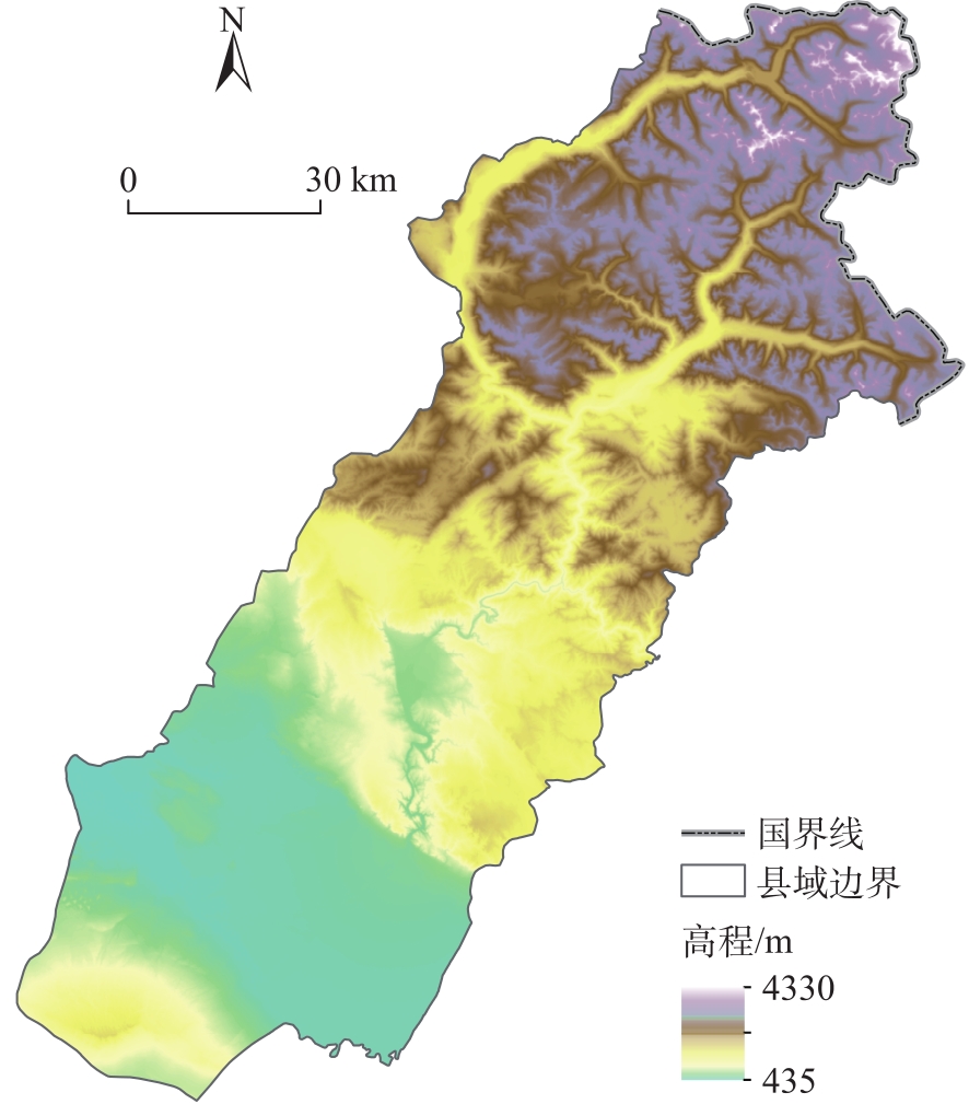
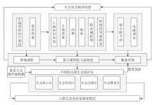
Fig. 2
Research ideas framework diagram"
Tab. 1
Table of threat factors"
| 威胁源 | 最大影响距离/km | 权重 | 衰退方式 |
|---|---|---|---|
| 耕地 | 7 | 0.8 | 线性 |
| 城镇用地 | 8 | 1.0 | 指数 |
| 农村居民点 | 8 | 1.0 | 指数 |
| 其他建设用地 | 6 | 0.7 | 指数 |
| 未利用地 | 5 | 0.6 | 线性 |
Tab. 2
Sensitivity table of land use types"
| 地类名称 | 生境 得分值 | 耕地 | 城镇 用地 | 农村 居民点 | 其他建 设用地 | 未利 用地 |
|---|---|---|---|---|---|---|
| 水浇地 | 0.3 | 0.0 | 0.8 | 0.6 | 0.7 | 0.4 |
| 有林地 | 1.0 | 0.7 | 0.9 | 0.8 | 0.8 | 0.6 |
| 灌木林 | 0.9 | 0.6 | 0.8 | 0.7 | 0.7 | 0.6 |
| 疏林地 | 0.8 | 0.7 | 0.7 | 0.6 | 0.6 | 0.5 |
| 高覆盖度草地 | 0.6 | 0.4 | 0.4 | 0.3 | 0.4 | 0.3 |
| 中覆盖度草地 | 0.5 | 0.3 | 0.4 | 0.3 | 0.3 | 0.3 |
| 低覆盖度草地 | 0.4 | 0.3 | 0.3 | 0.2 | 0.2 | 0.2 |
| 湖泊 | 1.0 | 0.8 | 0.8 | 0.8 | 0.8 | 0.7 |
| 水库坑塘 | 0.7 | 0.6 | 0.8 | 0.8 | 0.8 | 0.5 |
| 永久性冰川雪地 | 0.8 | 0.8 | 0.7 | 0.7 | 0.7 | 0.7 |
| 滩地 | 0.6 | 0.6 | 0.6 | 0.6 | 0.6 | 0.4 |
| 沙地 | 0.2 | 0.3 | 0.4 | 0.3 | 0.6 | 0.0 |
| 戈壁 | 0.3 | 0.3 | 0.5 | 0.4 | 0.6 | 0.0 |
| 沼泽地 | 0.5 | 0.4 | 0.2 | 0.2 | 0.3 | 0.0 |
| 裸土地 | 0.1 | 0.2 | 0.5 | 0.4 | 0.6 | 0.0 |
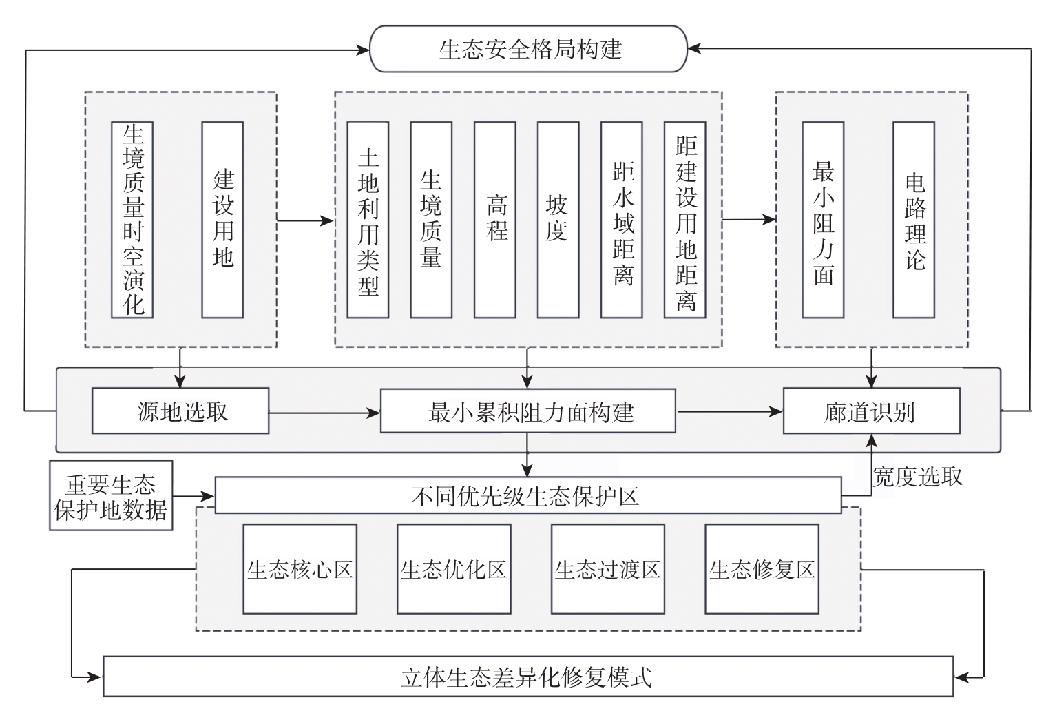
Tab. 3
Table of resistance factor system"
| 生态扩张 阻力分值 | 建设扩张 阻力分值 | 土地利用类型 | 生境质量 | 高程/m | 坡度/(°) | 距水域距离/m | 距建设用地距离/m |
|---|---|---|---|---|---|---|---|
| 1 | 5 | 水域、林地 | >0.8 | 3551~4330 | 56.34~70.42 | <500 | >1100 |
| 2 | 4 | 草地 | 0.6~0.8 | 2772~3551 | 42.25~56.34 | 500~1000 | 800~1100 |
| 3 | 3 | 未利用地 | 0.4~0.6 | 1993~2772 | 28.17~42.25 | 1000~1500 | 500~800 |
| 4 | 2 | 耕地 | 0.2~0.4 | 1214~1993 | 14.08~28.17 | 1500~2000 | 200~500 |
| 5 | 1 | 建设用地 | <0.2 | 435~1214 | 0.00~14.08 | >2000 | <200 |
| 权重 | 0.285 | 0.172 | 0.169 | 0.145 | 0.124 | 0.105 | |
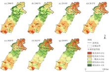
Fig. 3
Spatial distributions of habitat quality levels"

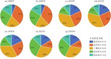
Fig. 4
Proportion of habitat quality levels"
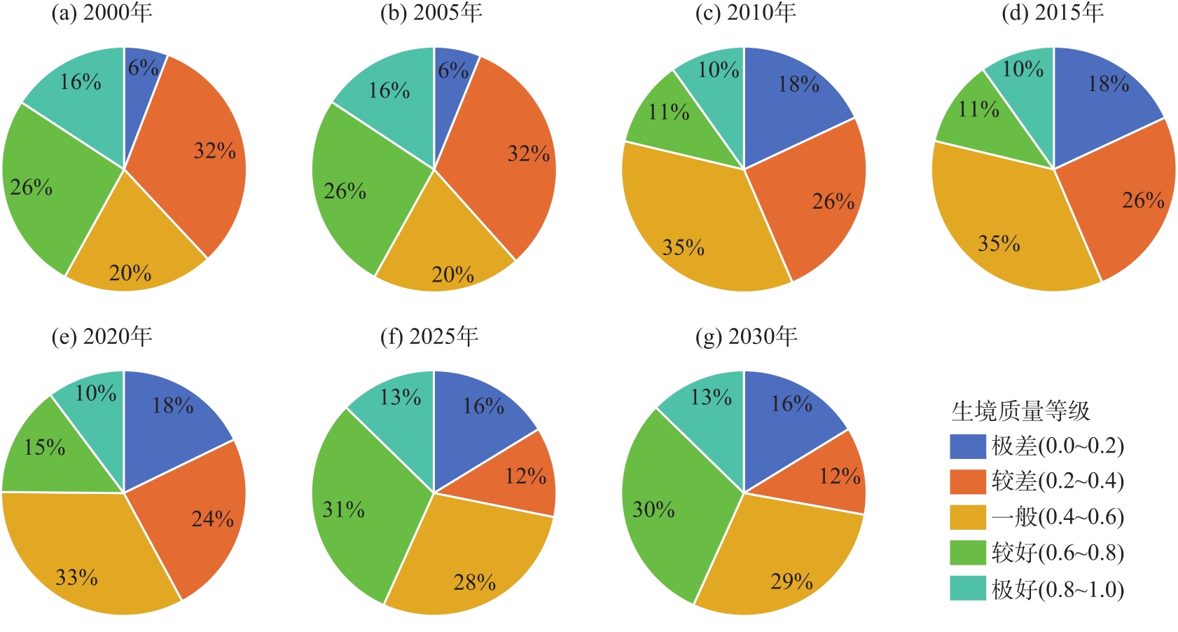

Fig. 5
Two types of sources area in Burqin County"
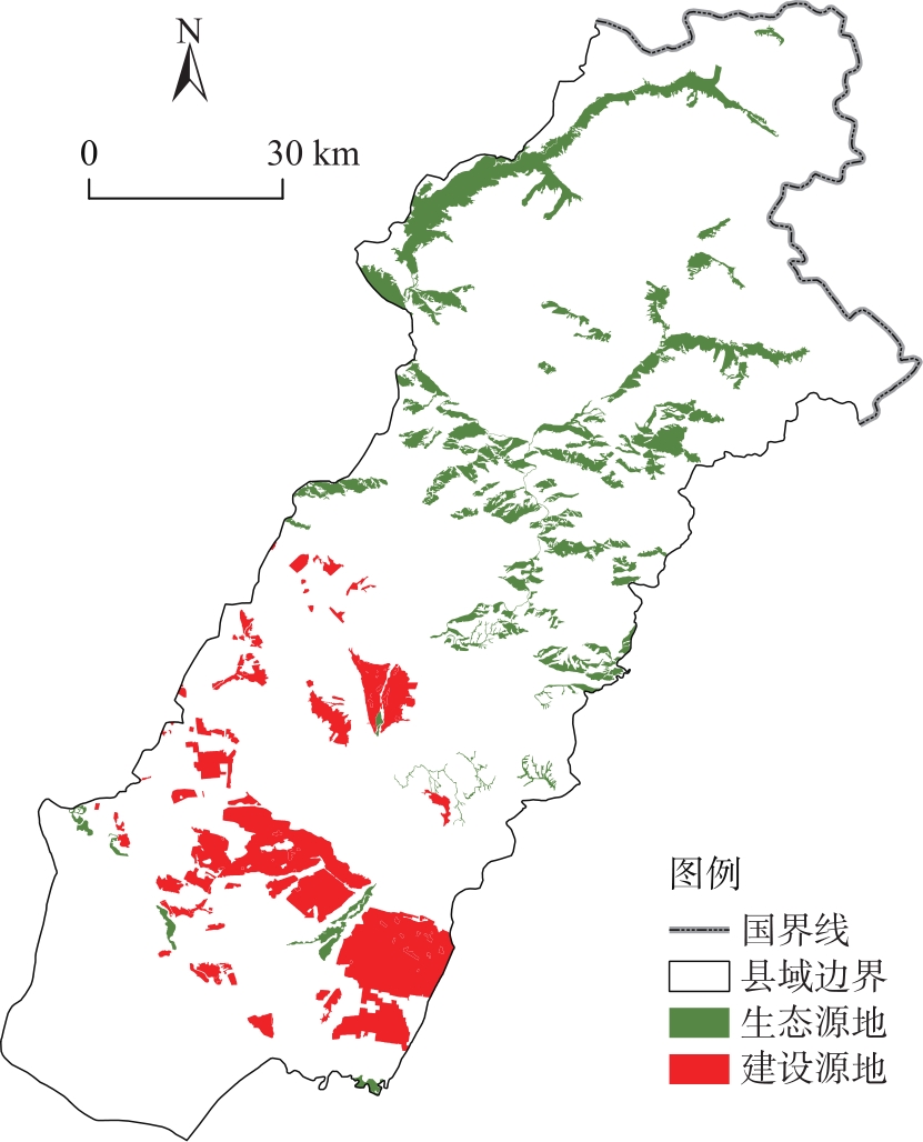
Fig. 6
Resistance surface for source area expansion"

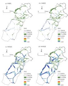
Fig 7
Distribution of corridors of different widths"
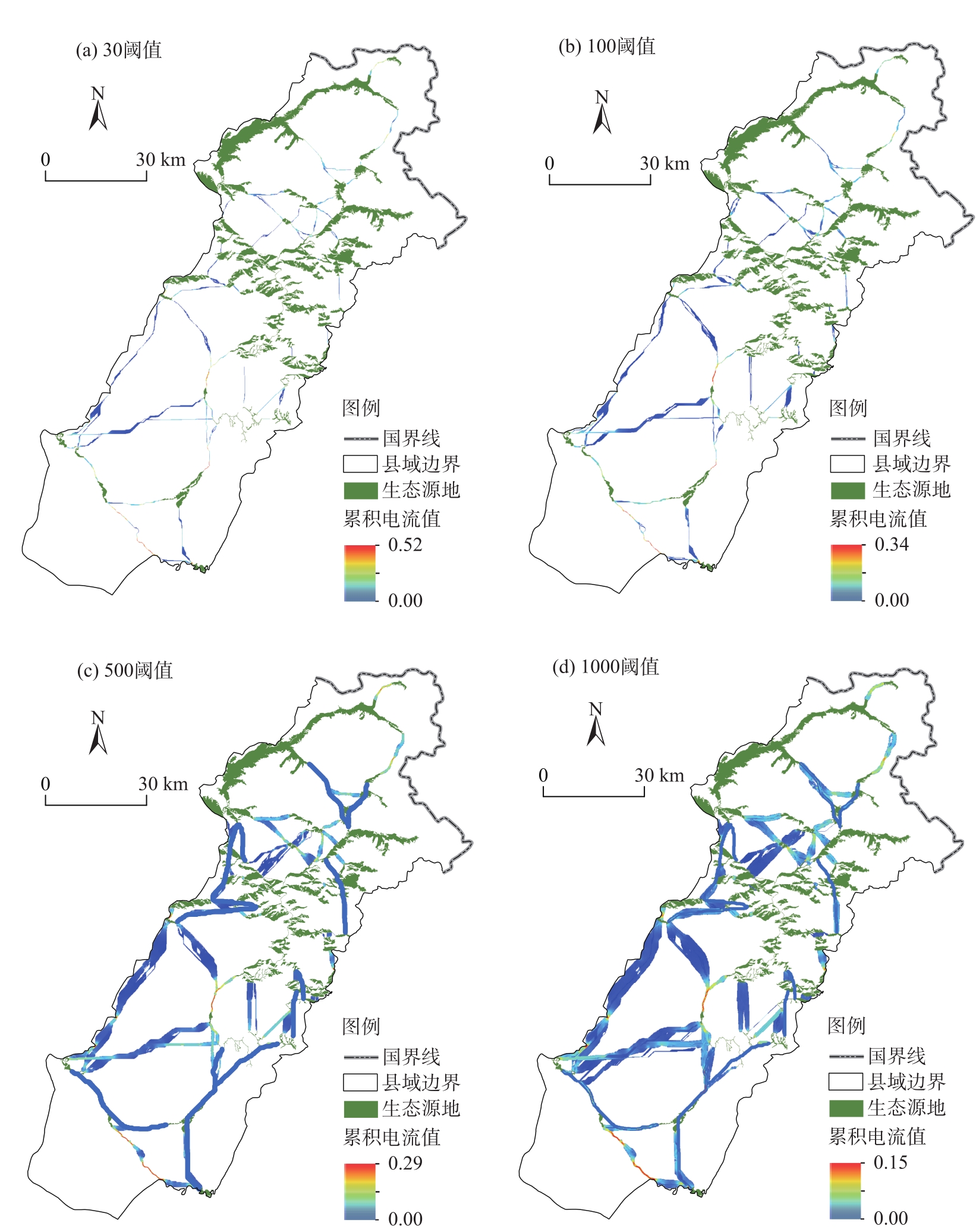
Fig. 8
Ecological reserves in Burqin County"
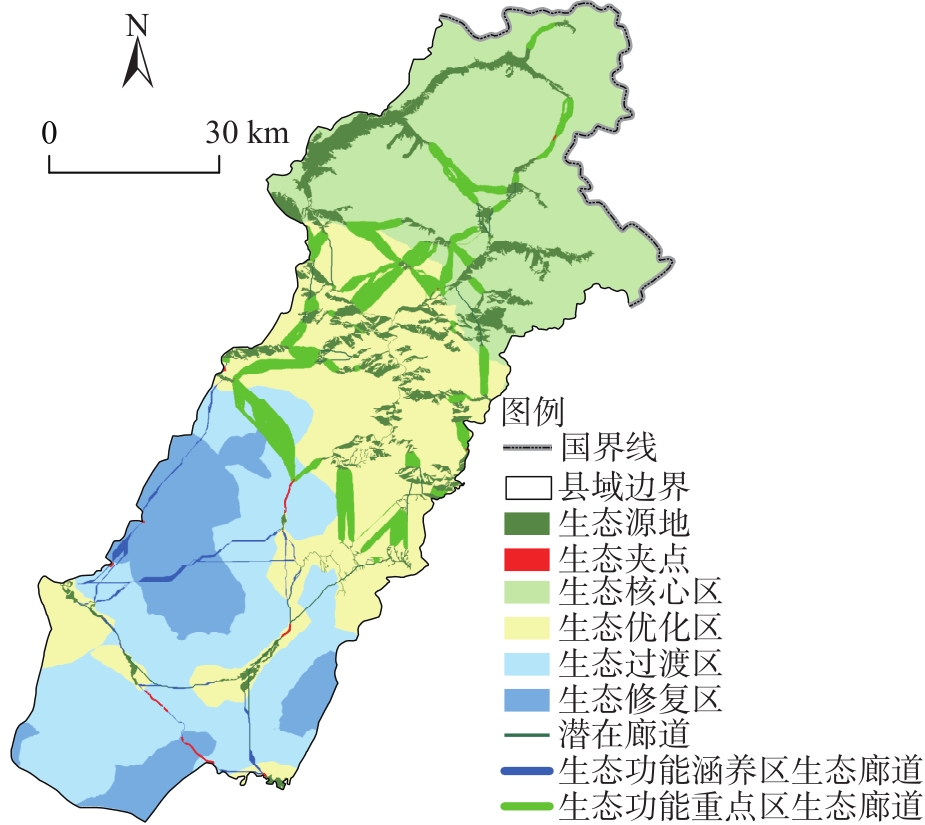
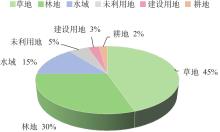
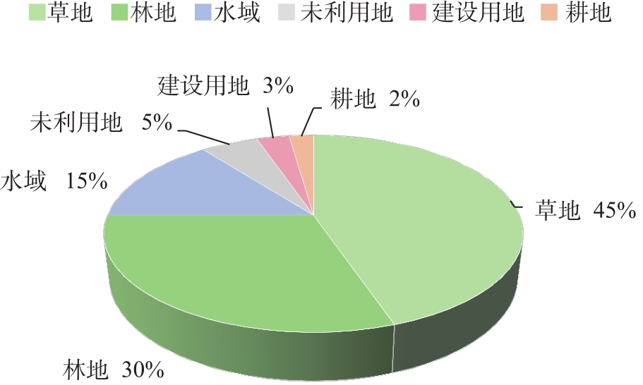
Fig. 9
Proportion of corridors to landuse types"
| [1] |
李涛, 巩雅博, 戈健宅, 等. 基于电路理论的城市景观生态安全格局构建——以湖南省衡阳市为例[J]. 应用生态学报, 2021, 32(7): 2555-2564.
doi: 10.13287/j.1001-9332.202107.020 |
|
[Li Tao, Gong Yabo, Ge Jianzhai, et al. Construction of urban landscape ecological security pattern based on circuit theory: A case study of Hengyang City, Hunan Province, China[J]. Chinese Journal of Applied Ecology, 2021, 32(7): 2555-2564.]
doi: 10.13287/j.1001-9332.202107.020 |
|
| [2] |
张晓东, 赵志鹏, 赵银鑫, 等. 银川市景观生态风险评价与生态安全格局优化构建[J]. 干旱区地理, 2022, 45(5): 1626-1636.
doi: 10.12118/j.issn.1000-6060.2022.021 |
|
[Zhang Xiaodong, Zhao Zhipeng, Zhao Yinxin, et al. Landscape ecological risk assessment and ecological security pattern optimization construction in Yinchuan City[J]. Arid Land Geography, 2022, 45(5): 1626-1636.]
doi: 10.12118/j.issn.1000-6060.2022.021 |
|
| [3] | Herath H, Halwatura R U, Jayasingh G Y. Evaluation of green infrastructure effects on tropical Sri Lankan urban context as an urban heat island adaptation strategy[J]. Urban Forestry & Urban Greening, 2018, 29: 212-222. |
| [4] |
Lewis A C. The changing face of urban air pollution[J]. Science, 2018, 359: 744-745.
doi: 10.1126/science.aar4925 pmid: 29449479 |
| [5] | 翟天林, 王静, 金志丰, 等. 长江经济带生态系统服务供需格局变化与关联性分析[J]. 生态学报, 2019, 39(15): 5414-5424. |
| [Zhai Tianlin, Wang Jing, Jin Zhifeng, et al. Change and correlation analysis of the supply-demand pattern of ecosystem services in the Yangtze River Economic Belt[J]. Acta Ecologica Sinica, 2019, 39(15): 5414-5424.] | |
| [6] | 李新琪, 王永嘉, 徐涛. “十四五”新疆维吾尔自治区生态状况监测工作思考[J]. 干旱环境监测, 2020, 34(4): 187-192. |
| [Li Xinqi, Wang Yongjia, Xu Tao. Overall consideration on ecological monitoring works of Xinjiang Uygur Autonomous Region during the 14th five-year plan period[J]. Arid Environmental Monitoring, 2020, 34(4): 187-192.] | |
| [7] |
李洪庆, 杨瑀, 张俊红. 雅鲁藏布江山南宽谷流域生态安全格局构建[J]. 干旱区地理, 2023, 46(9): 1503-1513.
doi: 10.12118/j.issn.1000-6060.2022.551 |
|
[Li Hongqing, Yang Yu, Zhang Junhong. Construction of ecological security pattern in Shannan Wide Valley Basin of Yarlung Zangbo River[J]. Arid Land Geography, 2023, 46(9): 1503-1513.]
doi: 10.12118/j.issn.1000-6060.2022.551 |
|
| [8] | Secretariat of the Convention on Biological Diversity. Global biodiversity outlook 5[R]. Montreal: Secretariat of the Convention on Biological Diversity, 2020. |
| [9] |
孙枫, 章锦河, 王培家, 等. 城市生态安全格局构建与评价研究: 以苏州市区为例[J]. 地理研究, 2021, 40(9): 2476-2493.
doi: 10.11821/dlyj020200990 |
| [Sun Feng, Zhang Jinhe, Wang Peijia, et al. Construction and evaluation of urban ecological security pattern: A case study of Suzhou City[J]. Geographical Research, 2021, 40(9): 2476-2493.] | |
| [10] | Zhang Y, Li X B, Song W. Determinants of cropland abandonment at the parcel, household and village levels in mountain areas of China: A multi-level analysis[J]. Land Use Policy, 2014, 41: 186-192. |
| [11] | 朱琪, 袁泉, 于大炮, 等. 基于电路理论的东北森林带生态安全网络构建[J]. 生态学杂志, 2021, 40(11): 3463-3473. |
|
[Zhu Qi, Yuan Quan, Yu Dapao, et al. Construction of ecological security network of northeast China forest belt based on the circuit theory[J]. Chinese Journal of Ecology, 2021, 40(11): 3463-3473.]
doi: DOI: 10.13292/j.1000-4890.202111.012 |
|
| [12] | 潘竟虎, 王云. 基于CVOR和电路理论的讨赖河流域生态安全评价及生态格局优化[J]. 生态学报, 2021, 41(7): 2582-2595. |
| [Pan Jinghu, Wang Yun. Ecological security evaluation and ecological pattern optimization in Taolai River Basin based on CVOR and circuit theory[J]. Acta Ecologica Sinica, 2021, 41(7): 2582-2595.] | |
| [13] |
陈南南, 康帅直, 赵永华, 等. 基于MSPA和MCR模型的秦岭(陕西段)山地生态网络构建[J]. 应用生态学报, 2021, 32(5): 1545-1553.
doi: 10.13287/j.1001-9332.202105.012 |
|
[Chen Nannan, Kang Shuaizhi, Zhao Yonghua, et al. Construction of ecological network in Qinling Mountains of Shaanxi, China based on MSPA and MCR model[J]. Chinese Journal of Applied Ecology, 2021, 32(5): 1545-1553.]
doi: 10.13287/j.1001-9332.202105.012 |
|
| [14] | Daniela T M, Luciano C J F, Eduarda S M, et al. Delimitation of ecological corridors between conservation units in the Brazilian cerrado using a GIS and AHP approach[J]. Ecological Indicators, 2020, 115: 106440, doi: 10.1016/j.ecolind.2020.106440. |
| [15] | Reed F, Noss. Corridors in real landscapes: A reply to Simberloff and Cox[J]. Conservation Biology, 1987, 1(2): 159-164. |
| [16] | Liu Z, Lin Y L, Bruno D M, et al. Heterogeneous landscapes of urban greenways in Shenzhen: Traffic impact, corridor width and land use[J]. Urban Forestry & Urban Greening, 2020, 55: 126785, doi: 10.1016/j.ufug.2020.126785. |
| [17] | Hou Q, Du Y, Dong W, et al. Smart city oriented ecological corridor layout of Sanshui River Basin in arid area of Loess Plateau[J]. Sustainable Energy Technologies and Assessments, 2021, 44: 100993, doi: 10.1016/j.seta.2021.100993. |
| [18] | Zhang L, Fu B, Lü Y, et al. Balancing multiple ecosystem services in conservation priority setting[J]. Landscape Ecology, 2015, 30: 535-546. |
| [19] | Myer N. Threatened biotas: “Hot spots” in tropical forests[J]. Environmentalist, 1988, 8(3): 187-208. |
| [20] | Wilson E O, Peter F M. Monitoring biological diversity for setting priorities in conservation[M]. Washington: National Academy Press, 1988, 227-230. |
| [21] | Yang R, Cao Y, Hou S Y, et al. Cost-effective priorities for the expansion of global terrestrial protected areas: Setting post-2020 global and national targets[J]. Science Advance, 2020, 6(37): eabc3436, doi: 10.1126/sciadv.abc3436. |
| [22] | Wei Q Q, Halike A, Yao K X, et al. Construction and optimization of ecological security pattern in Ebinur Lake Basin based on MSPA-MCR models[J]. Ecological Indicators, 2022, 138: 108857, doi: 10.1016/j.ecolind.2022.108857. |
| [23] | Huang X, Wang H, Shan L, et al. Constructing and optimizing urban ecological network in the context of rapid urbanization for improving landscape connectivity[J]. Ecological Indicators, 2021, 132: 108319, doi: 10.1016/j.ecolind.2021.108319. |
| [24] | 高庆彦, 潘玉君, 刘化. 基于InVEST模型的大理州生境质量时空演化研究[J]. 生态与农村环境学报, 2021, 37(3): 402-408. |
| [Gao Qingyan, Pan Yujun, Liu Hua. Spatial-temporal evolution of habitat quality in the Dali Bai Autonomous Prefecture based on the InVEST model[J]. Journal of Ecology and Rural Environment, 2021, 37(3): 402-408.] | |
| [25] | Richard S, Rebecca C K, Spencer W, et al. InVEST3.14.3. User’s guide: Integrated valuation of environmental services and tradeoffs[M]. Stanford: The Natural Capital Project, 2021. |
| [26] | 樊影, 王宏卫, 杨胜天, 等. 基于生境质量和生态安全格局的阿勒泰地区生态保护关键区域识别[J]. 生态学报, 2021, 41(19): 7614-7626. |
| [Fan Ying, Wang Hongwei, Yang Shengtian, et al. Identification of ecological protection crucial areas in Altay Prefecture based on habitat quality and ecological security pattern[J]. Acta Ecologica Sinica, 2021, 41(19): 7614-7626.] | |
| [27] | Knaapen J P, Scheffer M, Harms B. Estimating habitat isolation in landscape planning[J]. Landscape and Urban Planning, 1992, 23(1): 1-16. |
| [28] |
郝月, 张娜, 杜亚娟, 等. 基于生境质量的唐县生态安全格局构建[J]. 应用生态学报, 2019, 30(3): 1015-1024.
doi: 10.13287/j.1001-9332.201903.007 |
|
[Hao Yue, Zhang Na, Du Yajuan, et al. Construction of ecological security pattern based on habitat quality in Tang County, Hebei, China[J]. Chinese Journal of Applied Ecology, 2019, 30(3): 1015-1024.]
doi: 10.13287/j.1001-9332.201903.007 |
|
| [29] | Dong K N, Wang H W, Luo K, et al. The use of an optimized grey multi-objective programming-PLUS model for multi-scenario simulation of land use in the Weigan-Kuche River oasis, China[J]. Land, 2024, 13(6): 802, doi: 10.3390/land13060802. |
| [30] | 张晓瑶, 张潇, 李冬花, 等. 城市土地利用变化对生态系统服务价值影响的多情景模拟——以深圳市为例[J]. 生态学报, 2022, 42(6): 2086-2097. |
| [Zhang Xiaoyao, Zhang Xiao, Li Donghua, et al. Multi-scenario simulation of the impact of urban land use change on ecosystem service value in Shenzhen[J]. Acta Ecologica Acta Ecologica Sinica, 2022, 42(6): 2086-2097.] | |
| [31] | 袁贞贞, 王秋红, 王勇, 等. 多情景模拟下重庆市土地利用变化对生态系统健康的影响[J]. 生态学报, 2023, 43(20): 8279-8291. |
| [Yuan Zhengzheng, Wang Qiuhong, Wang Yong, et al. Impacts of land use change on ecosystem health in Chongqing under multi-scenario[J]. Acta Ecologica Sinica, 2023, 43(20): 8279-8291.] | |
| [32] |
胡丰, 张艳, 郭宇, 等. 基于PLUS和InVEST模型的渭河流域土地利用与生境质量时空变化及预测[J]. 干旱区地理, 2022, 45(4): 1125-1136.
doi: 10.12118/j.issn.1000-6060.2021.510 |
|
[Hu Feng, Zhang Yan, Guo Yu, et al. Spatial and temporal changes in land use and habitat quality in the Weihe River Basin based on the PLUS and InVEST models and predictions[J]. Arid Land Geography, 2022, 45(4): 1125-1136.]
doi: 10.12118/j.issn.1000-6060.2021.510 |
|
| [33] | 马亚兄. 基于生境质量的黄土丘陵区生态安全格局构建[D]. 兰州: 西北师范大学, 2021. |
| [Ma Yaxiong. Construction of ecological security pattern in loess hilly region based on habitat quality: Take Lanzhou City as an example[D]. Lanzhou: Northwest Normal University, 2021.] | |
| [34] | Luo K, Wang H W, Yan X M, et al. Integrating CVOR and circuit theory models to construct and reconstruct ecological networks: A case study from the Tacheng-Emin Basin, China[J]. Ecological Indicators, 2024, 165: 112170, doi: 10.1016/j.ecolind.2024.112170. |
| [35] |
宋利利, 秦明周. 整合电路理论的生态廊道及其重要性识别[J]. 应用生态学报, 2016, 27(10): 3344-3352.
doi: 10.13287/j.1001-9332.201610.035 |
|
[Song Lili, Qin Mingzhou. Identification of ecological corridors and its importance by integrating circuit theory[J]. Chinese Journal of Applied Ecology, 2016, 27(10): 3344-3352.]
doi: 10.13287/j.1001-9332.201610.035 |
|
| [36] | 朱强, 俞孔坚, 李迪华. 景观规划中的生态廊道宽度[J]. 生态学报, 2005, 25(9): 2406-2412. |
| [Zhu Qiang, Yu Kongjian, Li Dihua. The width of ecological corridor in landscape planning[J]. Acta Ecologica Sinica, 2005, 25(9): 2406-2412.] |
| Viewed | ||||||||||||||||||||||||||||||||||||||||||||||||||
|
Full text 40
|
|
|||||||||||||||||||||||||||||||||||||||||||||||||
|
Abstract 61
|
|
|||||||||||||||||||||||||||||||||||||||||||||||||
Cited |
|
|||||||||||||||||||||||||||||||||||||||||||||||||
| Shared | ||||||||||||||||||||||||||||||||||||||||||||||||||
|
||