Arid Land Geography ›› 2021, Vol. 44 ›› Issue (5): 1489-1499.doi: 10.12118/j.issn.1000–6060.2021.05.29
• Regional Development • Previous Articles Next Articles
YANG Zhenmin( ),LIU Xinping()
Received:2020-08-18
Revised:2021-04-12
Online:2021-09-25
Published:2021-09-22
Contact:
Xinping LIU
E-mail:yangzhenmin12@163.com;lxping16@163.com
YANG Zhenmin,LIU Xinping. Ecological carrying capacity monitoring and security pattern construction in the Aksu River Basin, Xinjiang[J].Arid Land Geography, 2021, 44(5): 1489-1499.

Fig. 1
Overview of the study area"

Tab. 1
Evaluation index system of ecological carrying capacity in the Aksu River Basin"
| 目标层 | 准则层 | 指标层 |
|---|---|---|
| 生态承载力 | 生态弹性力 | 温湿指数(+)、归一化植被指数(+)、土地退化指数(-)、土壤有机质含量(+)、生物丰度指数(+)、水网密度指数(+)、年降水量(+)、地形位指数(+) |
| 资源与环境承载力 | 第三产业占GDP比重(+)、人均耕地面积(+)、人均林地面积(+) | |
| 人类社会影响压力 | 人口密度(-)、经济密度(-)、城市化水平(+)、GDP增长率(-)、土地垦殖率(-)、工业二氧化硫排放量(-) |
Tab. 2
Classification of ecological resistance factors"
| 生态阻力等级 | 1 | 2 | 3 | 4 | 5 |
|---|---|---|---|---|---|
| 坡度/(°) | >40 | 20~40 | 13~20 | 8~13 | <8 |
| 高程/m | >4300 | 3000~4300 | 1700~3000 | 720~1700 | <720 |
| 景观类型 | 水域 | 林地 | 草地 | 耕地 | 建设用地、未利用地 |
| 土壤类型 | 水稻土、潜育水稻土、黑钙土 | 林灌草甸土、灰褐土 | 草甸土、草甸盐土 | 风沙土、灌淤土、潮土 | 棕漠土、盐化棕漠土、漠境盐土 |
| NDVI | >0.5 | 0.3~0.5 | 0.15~0.3 | 0~0.15 | <0 |
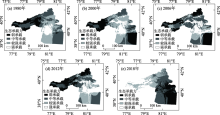
Fig. 2
Spatiotemporal changes of the ecological carrying capacity in the Aksu River Basin from 1980 to 2018"

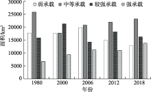
Fig. 3
Change of ecological carrying capacity area in the Aksu River Basin in different years from 1980 to 2018"
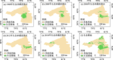
Fig. 4
Schematic diagram of ecological carrying advantage area in the Aksu River Basin"

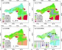
Fig. 5
Different cumulative distances from the surface of the production-living-ecological land superposition"

Tab. 3
Regional statistics of ecological security pattern"
| 代码 | 生态安全格局分区 | 面积/km2 | 百分比/% | 主要分布区域 |
|---|---|---|---|---|
| 11 | 生态保育区生态用地 | 23469 | 33.327 | 天山中段南麓西部保护区、天山南脉保护区、和田河流域、叶尔羌河流域、阿克苏河流域、乌什谷地保护区 |
| 43 | 生态防护区生活用地 | 8841 | 12.554 | 塔里木盆地西北边缘绿洲区 |
| 12 | 生态保育区生产用地 | 7542 | 10.710 | 山前洪积-冲积平原、中、低山丘陵的天然草场 |
| 13 | 生态保育区生活用地 | 5983 | 8.496 | 山前洪积-冲积平原、中、低山丘陵的天然草场 |
| 21 | 优化缓冲区生态用地 | 5875 | 8.343 | 以草地为主、主要山脉的草甸区 |
| 23 | 优化缓冲区生活用地 | 5598 | 7.949 | 优化缓冲区生产用地 |
| 33 | 生态过渡区生活用地 | 4446 | 6.313 | 托什干河流域、叶尔羌河流域、和田河流域 |
| 10 | 生态保育区未利用地 | 3321 | 4.716 | 高大山脉顶部、绿洲区 |
| 20 | 优化缓冲区未利用地 | 1945 | 2.762 | 高大山脉顶部、绿洲边缘区 |
| 31 | 生态过渡区生态用地 | 1354 | 1.923 | 托什干河南部边缘绿洲区,主要以草地为主 |
| 30 | 生态过渡区未利用地 | 871 | 1.237 | 戈壁、沙漠区 |
| 40 | 生态防护区未利用地 | 573 | 0.814 | 戈壁、沙漠区 |
| 41 | 生态防护区生态用地 | 424 | 0.602 | 塔克拉玛干沙漠西北边缘绿洲区,以草地为主 |
| 22 | 优化缓冲区生产用地 | 171 | 0.243 | 山麓砾质扇形地、冲积平原区 |
| 32 | 生态过渡区生产用地 | 8 | 0.011 | 托什干河流域、叶尔羌河流域、和田河流域 |
| 42 | 生态防护区生产用地 | 0 | 0.000 |
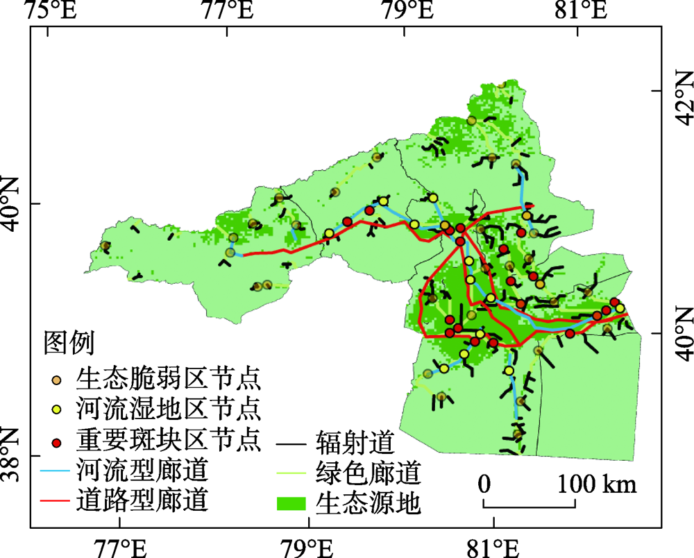
Fig. 6
Optimization diagram of ecological corridor and node pattern"
| [1] | 乌宁巴特, 刘新平, 马相平. 叶尔羌河流域土地生态脆弱性差异评价[J]. 干旱区地理, 2020, 43(3):849-858. |
| [ Wuningbart, Liu Xinping, Ma Xiangping. Evaluation on the difference of land ecological vulnerability in the Yarkant River Basin[J]. Arid Land Geography, 2020, 43(3):849-858. ] | |
| [2] | 张学斌, 石培基, 罗君, 等. 基于景观格局的干旱内陆河流域生态风险分析--以石羊河流域为例[J]. 自然资源学报, 2014, 29(3):410-419. |
| [ Zhang Xuebin, Shi Peiji, Luo Jun, et al. The ecological risk assessment of arid inland river basin at the landscape scale: A case study on Shiyang River Basin[J]. Journal of Natural Resources, 2014, 29(3):410-419. ] | |
| [3] | 魏光辉, 姜振盈, 张洛晨. 基于模糊综合评价的新疆阿克苏河流域环境承载力研究[J]. 浙江水利水电学院学报, 2018, 30(3):30-34. |
| [ Wei Guanghui, Jiang Zhenying, Zhang Luochen. Assessment of water environmental carrying capacity in Akesu River Basin based on fuzzy comprehensive evaluation model[J]. Journal of Zhejiang University of Water Resources and Electric Power, 2018, 30(3):30-34. ] | |
| [4] | 张旭, 刘新华, 张桂林, 等. 新疆阿克苏河流域水资源承载力变化分析[J]. 水电能源科学, 2020, 38(9):44-47. |
| [ Zhang Xu, Liu Xinhua, Zhang Guilin, et al. Analysis of change of water resources carrying capacity in the Aksu River Basin in Xinjiang[J]. Water Resources and Power, 2020, 38(9):44-47. ] | |
| [5] | 艾克旦·依萨克, 满苏尔·沙比提, 阿曼妮萨·库尔班, 等. 阿克苏河流域绿洲生态安全评价及影响因子分析[J]. 环境科学与技术, 2020, 43(7):217-223. |
| [ Essak Akidan, Sabit Mansur, Kurban Amannisa, et al. Ecological security evaluation and impact factor analysis of oasis in Aksu River Basin[J]. Environmental Science & Technology, 2020, 43(7):217-223. ] | |
| [6] |
柏玲, 陈忠升, 王充, 等. 西北干旱区阿克苏河径流对气候波动的多尺度响应[J]. 地理科学, 2017, 37(5):799-806.
doi: 10.13249/j.cnki.sgs.2017.05.018 |
|
[ Bai Ling, Chen Zhongsheng, Wang Chong, et al. Multi-scale response of runoff to climate change in the Aksu River Basin in arid area of the northwestern China[J]. Scientia Geographica Sinica, 2017, 37(5):799-806. ]
doi: 10.13249/j.cnki.sgs.2017.05.018 |
|
| [7] | 孙晓雷. 基于RS和GIS的阿克苏河流域土壤侵蚀研究[J]. 环境科学与技术, 2016, 39(增刊1):418-421. |
| [ Sun Xiaolei. Study on soil erosion of Aksu River Basin based on RS and GIS[J]. Environmental Science & Technology, 2016, 39(Suppl.1):418-421. ] | |
| [8] | 蒋军新, 蔡明, 徐永军, 等. 新疆阿克苏河流域洪水演变趋势研究[J]. 冰川冻土, 2021, 43(1):1-10. |
| [ Jiang Junxin, Cai Ming, Xu Yongjun, et al. The changing nature of flooding in the Aksu River Basin[J]. Journal of Glaciology and Geocryology, 2021, 43(1):1-10. ] | |
| [9] | 段峥嵘, 祖拜代·木依布拉, 夏建新, 等. 气候及土地类型变化条件下阿克苏绿洲耗水特征演变[J]. 应用基础与工程科学学报, 2018, 26(6):1203-1216. |
| [ Duan Zhengrong, Muyibula Zubaidai, Xia Jianxin, et al. Water consumption characteristics and evolution in Aksu oasis under climate variations and land-use changes[J]. Journal of Basic Science and Engineering, 2018, 26(6):1203-1216. ] | |
| [10] | 王生霞, 叶柏生, 丁永建, 等. 绿洲耗水对阿克苏河流域地表径流的影响[J]. 干旱区研究, 2013, 30(2):203-210. |
| [ Wang Shengxia, Ye Baisheng, Ding Yongjian, et al. The effect of water consumption on surface runoff in oasis in the Aksu River Basin[J]. Arid Zone Research, 2013, 30(2):203-210. ] | |
| [11] | 孙可可, 陈青青, 陈超群, 等. 基于水资源干旱指数的阿克苏绿洲干旱预警模式及其应用[J]. 灌溉排水学报, 2017, 36(5):84-89. |
| [ Sun Keke, Chen Qingqing, Chen Chaoqun, et al. A drought index-based model and its application to Aksu oasis[J]. Journal of Irrigation and Drainage, 2017, 36(5):84-89. ] | |
| [12] | 王志成, 蒋军新, 方功焕, 等. 水资源约束下的阿克苏河流域适宜绿洲规模分析[J]. 冰川冻土, 2019, 41(4):986-992. |
| [ Wang Zhicheng, Jiang Junxin, Fang Gonghuan, et al. Analysis on the suitable scale of the Aksu oasis under the limit of water resources[J]. Journal of Glaciology and Geocryology, 2019, 41(4):986-992. ] | |
| [13] | 张学渊, 魏伟, 颉斌斌, 等. 西北干旱区生态承载力监测及安全格局构建[J]. 自然资源学报, 2019, 34(11):2389-2402. |
| [ Zhang Xueyuan, Wei Wei, Jie Binbin, et al. Ecological carrying capacity monitoring and security pattern construction in arid areas of northwest China[J]. Journal of Natural Resources, 2019, 34(11):2389-2402. ] | |
| [14] | 尤朝辉. 基于系统动力学的淮南市生态承载力评价分析[D]. 合肥: 安徽建筑大学, 2018. |
| [ You Chaohui. Evaluation and analysis of ecological carrying capacity of Huainan City based on system dynamics[D]. Hefei: Anhui Jianzhu University, 2018. ] | |
| [15] | 曹智, 闵庆文, 刘某承, 等. 基于生态系统服务的生态承载力: 概念、内涵与评估模型及应用[J]. 自然资源学报, 2015, 30(1):1-11. |
| [ Cao Zhi, Min Qingwen, Liu Moucheng, et al. Ecosystem-service-based ecological carrying capacity: Concept, content, assessment model and application[J]. Journal of Natural Resources, 2015, 30(1):1-11. ] | |
| [16] | 高吉喜, 陈圣宾. 依据生态承载力优化国土空间开发格局[J]. 环境保护, 2014, 42(24):12-18. |
| [ Gao Jixi, Chen Shengbin. Optimize the spacial structure based on ecological capacity[J]. Environmental Protection, 2014, 42(24):12-18. ] | |
| [17] | 杨斌, 王占岐, 姚小薇, 等. 鄂西北山区土地利用的地形梯度效应与空间结构特征[J]. 长江流域资源与环境, 2019, 28(2):313-321. |
| [ Yang Bin, Wang Zhanqi, Yao Xiaowei, et al. Terrain gradient effect and spatial structure characteristics of land use in mountain areas of northwestern Hubei Province[J]. Resources and Environment in the Yangtze Basin, 2019, 28(2):313-321. ] | |
| [18] |
施国萍, 何永健, 张眉, 等. 基于GridMet模型的浙江省温湿指数空间分布及地形影响分析[J]. 地球信息科学学报, 2019, 21(12):1923-1933.
doi: 10.12082/dqxxkx.2019.180635 |
|
[ Shi Guoping, He Yongjian, Zhang Mei, et al. Spatial distribution of THI in Zhejiang Province based on the GridMet model[J]. Journal of Geo-information Science, 2019, 21(12):1923-1933. ]
doi: 10.12082/dqxxkx.2019.180635 |
|
| [19] | 莫维燊. 基于土地资源承载力评价的国土空间优化研究--以广西宁明县为例[D]. 南宁: 南宁师范大学, 2019. |
| [ Mo Weishen. National spatial optimization based on land resource carrying capacity evaluation: A case study of Guangxi Ningming County[D]. Nanning: Nanning Normal University, 2019. ] | |
| [20] | 廖炜, 李璐, 吴宜进, 等. 丹江口库区土地利用变化与生态环境脆弱性评价[J]. 自然资源学报, 2011, 26(11):1879-1889. |
| [ Liao Wei, Li Lu, Wu Yijin, et al. Land use change and eco-environmental vulnerability evaluation in the Danjiangkou reservoir erea[J]. Journal of Natural Resources, 2011, 26(11):1879-1889. ] | |
| [21] | 俞孔坚, 王思思, 李迪华, 等. 北京市生态安全格局及城市增长预景[J]. 生态学报, 2009, 29(3):1189-1204. |
| [ Yu Kongjian, Wang Sisi, Li Dihua, et al. The function of ecological security patterns as an urban growth framework in Beijing[J]. Acta Ecologica Sinica, 2009, 29(3):1189-1204. ] | |
| [22] | 杨发鹏, 张雪唱, 李宗阳. 城市旅游“三生”竞争力空间分异--以西北五省为例[J]. 干旱区地理, 2019, 42(3):664-672. |
| [ Yang Fapeng, Zhang Xuechang, Li Zongyang. Spatial differentiation of the “production-life-ecology” competitiveness in urban tourism: A case study of five provinces in northwest China[J]. Arid Land Geography, 2019, 42(3):664-672. ] | |
| [23] |
邓华, 邵景安, 王金亮, 等. 多因素耦合下三峡库区土地利用未来情景模拟. 地理学报, 2016, 71(11):1979-1997.
doi: 10.11821/dlxb201611009 |
|
[ Deng Hua, Shao Jing’an, Wang Jinliang, et al. Land use driving forces and its future scenario simulation in the three gorges reservoir area using CLUE-S model[J]. Acta Geographica Sinica, 2016, 71(11):1979-1997. ]
doi: 10.11821/dlxb201611009 |
|
| [24] | 张红旗, 许尔琪, 朱会义. 中国“三生用地”分类及其空间格局[J]. 资源科学, 2015, 37(7):1332-1338. |
| [ Zhang Hongqi, Xu Erqi, Zhu Huiyi. An ecological-living-industrial land classification system and its spatial distribution in China[J]. Resources Science, 2015, 37(7):1332-1338. ] |
|
||