Arid Land Geography ›› 2024, Vol. 47 ›› Issue (5): 850-860.doi: 10.12118/j.issn.1000-6060.2023.541
• Biology and Pedology • Previous Articles Next Articles
ZHU Lei1,2( ), WANG Ke1,2, DING Yimin1,2(), SUN Zhenyuan1,2, SUN Boyan1,2
Received:2023-10-01
Revised:2023-12-28
Online:2024-05-25
Published:2024-05-30
Contact:
DING Yimin
E-mail:nxuzhulei@163.com;haojingdig03@hotmail.com
ZHU Lei, WANG Ke, DING Yimin, SUN Zhenyuan, SUN Boyan. Early identification of rice and corn planting distribution in Qingtongxia irrigation area based on Sentinel-2[J].Arid Land Geography, 2024, 47(5): 850-860.
Tab. 1
Summary of main crop growth periods in Qingtongxia irrigation area"
| 月份 | 2 | 3 | 4 | 5 | 6 | 7 | 8 | 9 | |||||||||||||||||||||
|---|---|---|---|---|---|---|---|---|---|---|---|---|---|---|---|---|---|---|---|---|---|---|---|---|---|---|---|---|---|
| 旬 | 下 | 上 | 中 | 下 | 上 | 中 | 下 | 上 | 中 | 下 | 上 | 中 | 下 | 上 | 中 | 下 | 上 | 中 | 下 | 上 | 中 | 下 | |||||||
| 水稻 | 播种 | 出苗 | 分蘖 | 拔节 | 抽穗 | 乳熟 | 成熟 | ||||||||||||||||||||||
| 玉米 | 播种 | 出苗 | 拔节 | 抽雄 | 开花 | 灌浆 | 成熟 | ||||||||||||||||||||||
| 小麦 | 播种 | 出苗 | 三叶 | 分蘖 | 拔节 | 抽穗 | 开花 | 灌浆 | 成熟 | ||||||||||||||||||||
| 葡萄 | 展藤 | 萌芽 | 出叶 | 开花 | 坐果 | 膨大 | 转色 | 成熟 | |||||||||||||||||||||
| 枸杞 | 萌芽 | 展叶 | 开花 | 幼果 | 成熟 | ||||||||||||||||||||||||
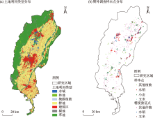
Fig. 1
Distributions of land use types and field survey sample points in Qingtongxia irrigation area"

Tab. 2
Sentinel-2 satellite L2A level images involved in this study in the Qingtongxia irrigation area"
| 生育期 | 获取时间 (年-月-日) | 传感器与数据级别 | 数量/景 | 云覆盖率/% |
|---|---|---|---|---|
| 播种前 | 2022-01-04 | S2A-MSIL2A | 6 | <8 |
| 2022-03-15 | S2A-MSIL2A | 6 | <5 | |
| 播种期 | 2022-04-06 | S2B-MSIL2A | 5 | <5 |
| 2022-04-24 | S2A-MSIL2A | 5 | <8 | |
| 2022-05-01 | S2A-MSIL2A | 6 | <8 | |
| 2022-05-09 | S2B-MSIL2A | 6 | <5 | |
| 出苗期 | 2022-05-16 | S2B-MSIL2A | 5 | <8 |
| 2022-05-24 | S2A-MSIL2A | 6 | <8 | |
| 2022-05-31 | S2A-MSIL2A | 6 | <5 | |
| 拔节期 | 2022-06-05 | S2B-MSIL2A | 6 | <5 |
| 2022-06-13 | S2A-MSIL2A | 6 | <5 | |
| 2022-06-15 | S2B-MSIL2A | 6 | <5 | |
| 2022-06-30 | S2A-MSIL2A | 6 | <5 |

Fig. 2
Flow chart of early rice and corn extraction technology"


Fig. 3
Temporal curves of MNDWI and NDVI for major crops in the Qingtongxia irrigation area in 2022"
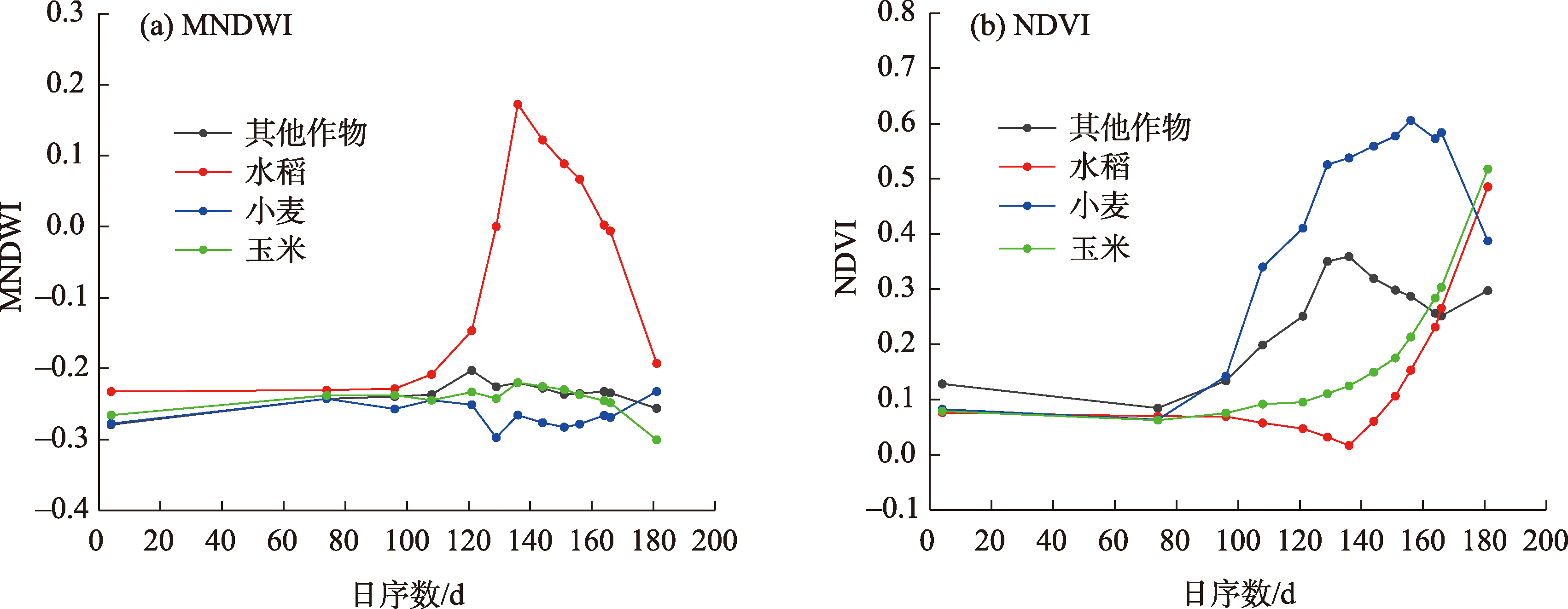
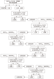
Fig. 4
Rules of classification decision tree"

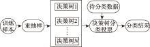
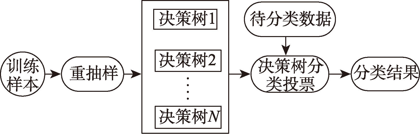
Fig. 5
Flow of random forest algorithm"
Tab. 3
Accuracy evaluation based on early phenological feature extraction methods"
| 生育期 | 日期 | 玉米 | 水稻 | 总体精度/% | Kappa系数 | |||
|---|---|---|---|---|---|---|---|---|
| 制图精度/% | 用户精度/% | 制图精度/% | 用户精度/% | |||||
| 播种期 | 5月1日—16日 | 95.62 | 94.33 | 93.02 | 92.66 | 97.0413 | 0.920 | |
| 出苗期 | 5月1日—24日 | 95.25 | 93.31 | 94.87 | 93.34 | 95.4182 | 0.908 | |
| 5月1日—31日 | 93.49 | 92.87 | 93.54 | 91.56 | 91.5336 | 0.882 | ||
| 拔节期 | 5月1日—6月05日 | 90.96 | 91.41 | 92.06 | 93.14 | 90.6971 | 0.851 | |
| 5月1日—6月13日 | 89.36 | 90.61 | 90.84 | 91.33 | 89.5663 | 0.801 | ||
| 5月1日—6月30日 | 63.53 | 92.86 | 95.87 | 75.69 | 81.0671 | 0.609 | ||

Fig. 6
Spatial distributions of rice and corn cultivation extracted with different schemes"

Tab. 4
Accuracy evaluation based on random forest classification method"
| 生育期 | 日期 | 玉米 | 水稻 | 总体精度/% | Kappa系数 | |||
|---|---|---|---|---|---|---|---|---|
| 制图精度/% | 用户精度/% | 制图精度/% | 用户精度/% | |||||
| 播种期 | 5月16日 | 89.34 | 87.56 | 90.01 | 89.35 | 90.01 | 0.89 | |
| 出苗期 | 5月24日 | 89.98 | 90.20 | 89.97 | 90.02 | 90.06 | 0.87 | |
| 5月31日 | 87.34 | 88.75 | 86.37 | 89.23 | 89.09 | 0.84 | ||
| 拔节期 | 6月05日 | 90.02 | 90.51 | 90.07 | 91.24 | 90.76 | 0.90 | |
| 6月13日 | 88.09 | 90.03 | 89.67 | 90.01 | 89.12 | 0.85 | ||
| 6月30日 | 91.03 | 90.5 | 86.08 | 87.09 | 86.57 | 0.86 | ||
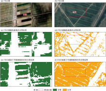
Fig. 7
Comparison of the effectiveness of two classification methods in typical regions"

Tab. 5
Kappa coefficient analysis"
| 方法 | 最大值 | 最大值日期 (年-月-日) | Kappa系数≥0.9 的首个日期(年-月-日) |
|---|---|---|---|
| 基于早期物候特征方法 | 0.92 | 2022-05-16 | 2022-05-16 |
| 随机森林方法 | 0.90 | 2022-06-05 | 2022-06-05 |
| [1] | 孙智虎, 张锦水, 洪友堂, 等. GF-7卫星多角度特征作物识别[J]. 遥感学报, 2023, 27(9): 2127-2138. |
| [Sun Zhihu, Zhang Jinshui, Hong Youtang, et al. Crop recognition by multiangle features of GF-7 satellite[J]. National Remote Sensing Bulletin, 2023, 27(9): 2127-2138. ] | |
| [2] | 田艳君, 石莹, 帅艳民, 等. 基于遥感时序特征的地表覆被信息提取[J]. 干旱区地理, 2021, 44(2): 450-459. |
| [Tian Yanjun, Shi Ying, Shuai Yanmin, et al. Land cover information retrieval from temporal features based remote sensing images[J]. Arid Land Geography, 2021, 44(2): 450-459. ] | |
| [3] | 白燕英, 高聚林, 张宝林. 基于Landsat8影像时间序列NDVI的作物种植结构提取[J]. 干旱区地理, 2019, 42(4): 893-901. |
| [Bai Yanying, Gao Julin, Zhang Baolin. Extraction of crop planting structure based on time-series NDVI of Landsat8 images[J]. Arid Land Geography, 2019, 42(4): 893-901. ] | |
| [4] | 欧阳玲, 毛德华, 王宗明, 等. 基于GF-1与Landsat8 OLI影像的作物种植结构与产量分析[J]. 农业工程学报, 2017, 33(11): 147-156. |
| [Ou Yangling, Mao Dehua, Wang Zongming, et al. Analysis crops planting structure and yield based on GF-1 and Landsat8 OLI images[J]. Transactions of the Chinese Society of Agricultural Engineering, 2017, 33(11): 147-156. ] | |
| [5] | 刘焕军, 孟令华, 邱政超, 等. 棉花生长初期灌溉信息遥感提取与校正[J]. 中国生态农业学报, 2017, 25(8): 1216-1223. |
| [Liu Huanjun, Meng Linghua, Qiu Zhengchao, et al. Using remote sensing to extract and correct irrigation data during early cotton growth stage[J]. Chinese Journal of Eco-Agriculture, 2017, 25(8): 1216-1223. ] | |
| [6] | 尹瀚民, 古丽·加帕尔, 于涛, 等. 哈萨克斯坦北部小麦遥感估产方法研究[J]. 干旱区地理, 2022, 45(2): 488-498. |
| [Yin Hanmin, Jiapaer Guli, Yu Tao, et al. Research on remote sensing estimation of wheat yield in northern Kazakhstan[J]. Arid Land Geography, 2022, 45(2): 488-498. ] | |
| [7] | 郝鹏宇. 基于多时相遥感数据的农作物分类研究[D]. 北京: 中国科学院大学, 2017. |
| [Hao Pengyu. Crop classification using time series remote sensing data[D]. Beijing: University of the Chinese Academy of Sciences, 2017. ] | |
| [8] | 郝鹏宇, 唐华俊, 陈仲新, 等. 基于历史增强型植被指数时序的农作物类型早期识别[J]. 农业工程学报, 2018, 34(13): 179-186. |
| [Hao Pengyu, Tang Huajun, Chen Zhongxin, et al. Early season crop type recognition based on historical EVI time series[J]. Transactions of the Chinese Society of Agricultural Engineering, 2018, 34(13): 179-186. ] | |
| [9] | 徐美, 阮本清, 黄诗峰, 等. 灌区作物种植结构遥感监测及其应用[J]. 水利学报, 2007, 38(7): 879-885. |
| [Xu Mei, Ruan Benqing, Huang Shifeng, et al. Monitoring of crop variety distribution by remote sensing and its application[J]. Journal of Hydraulic Engineering, 2007, 38(7): 879-885. ] | |
| [10] | Cai Y P, Guan K Y, Peng J, et al. A high-performance and in-season classification system of field-level crop types using time-series Landsat data and a machine learning approach[J]. Remote Sensing of Environment, 2018, 210: 35-47. |
| [11] | Zhou F Q, Zhang A N, Townley-Smith L. A data mining approach for evaluation of optimal time-series of MODIS data for land cover mapping at a regional level[J]. ISPRS Journal of Photogrammetry and Remote Sensing, 2013, 84: 114-129. |
| [12] | Villa P, Stroppiana D, Fontanelli G, et al. In-season mapping of crop type with optical and X-Band SAR data: A classification tree approach using synoptic seasonal features[J]. Remote Sensing, 2015, 7(10): 12859-12886. |
| [13] | Azar R, Villa P, Stroppiana D, et al. Assessing in-season crop classification performance using satellite data: A test case in northern Italy[J]. European Journal of Remote Sensing, 2016, 49(1): 361-380. |
| [14] | 杨丽慧. 青铜峡灌区农业节水的农田水土环境响应研究[D]. 北京: 中国水利水电科学研究院, 2017. |
| [Yang Lihui. Research on farmland water and soil environment response to water saving in Qingtongxia irrigation district[D]. Beijing: China Academy of Water Resources and Hydropower Research, 2017. ] | |
| [15] | Weinmann M, Maier P M, Florath J, et al. Investigations on the potential of hyperspectral and Sentinel-2 data for land-cover/land-use classification[J]. ISPRS Annals of the Photogrammetry, Remote Sensing and Spatial Information Sciences, 2018, 4: 155-162. |
| [16] | Xia T, Ji W W, Li W D, et al. Phenology-based decision tree classification of rice-crayfish fields from Sentinel-2 imagery in Qianjiang, China[J]. International Journal of Remote Sensing, 2021, 42(21): 8124-8144. |
| [17] | 苏伟, 张明政, 蒋坤萍, 等. Sentinel-2卫星影像的大气校正方法[J]. 光学学报, 2018, 38(1): 322-331. |
| [Su Wei, Zhang Mingzheng, Jiang Kunping, et al. Atmospheric correction method for Sentinel-2 Satellite imagery[J]. Acta Optica Sinica, 2018, 38(1): 322-331. ] | |
| [18] | 张悦琦, 李荣平, 穆西晗, 等. 基于多时相GF-6遥感影像的水稻种植面积提取[J]. 农业工程学报, 2021, 37(17): 189-196. |
| [Zhang Yueqi, Li Rongping, Mu Xihan, et al. Extraction of paddy rice planting areas based on multi-temporal GF-6 remote sensing images[J]. Transactions of the Chinese Society of Agricultural Engineering, 2021, 37(17): 189-196. ] | |
| [19] | 魏浩东, 杨靖雅, 蔡志文, 等. 物候窗口和多源中高分辨率影像的稻虾田提取[J]. 遥感学报, 2022, 26(7): 1423-1436. |
| [Wei Haodong, Yang Jingya, Cai Zhiwen, et al. Extraction of rice and shrimp fields from phenological windows and multi-source high-resolution images[J]. Journal of Remote Sensing, 2022, 26(7): 1423-1436. ] | |
| [20] | 徐涵秋. 利用改进的归一化差异水体指数(MNDWI)提取水体信息的研究[J]. 遥感学报, 2005, 9(5): 589-595. |
| [Xu Hanqiu. A study on information extraction of water body with the modified normalized difference water index (MNDWI)[J]. National Remote Sensing Bulletin, 2005, 9(5): 589-595. ] | |
| [21] |
姜伊兰, 陈保旺, 黄玉芳, 等. 基于Google Earth Engine和NDVI时序差异指数的作物种植区提取[J]. 地球信息科学学报, 2021, 23(5): 938-947.
doi: 10.12082/dqxxkx.2021.200291 |
| [Jiang Yilan, Chen Baowang, Huang Yu fang, et al. Crop planting area extraction based on Google Earth Engine and NDVI time series difference index[J]. Journal of Geo-information Science, 2021, 23(5): 938-947. ] | |
| [22] | Breiman L. Random forests[J]. Machine Learning, 2001(45): 5-32. |
| [23] | 杨庆振, 郭敏, 范新成. 基于随机森林算法的高光谱遥感作物分类[J]. 测绘与空间地理信息, 2023, 46(4): 149-151, 154. |
| [Yang Qingzhen, Guo Min, Fan Xincheng. Hyperspectral remote sensing crop classification based on random forest algorithm[J]. Surveying and Spatial Geographic Information, 2023, 46(4): 149-151, 154. ] | |
| [24] | 解毅, 王佳楠, 刘钰. 基于Sentinel-1/2数据特征优选的冬小麦种植区识别方法研究[J]. 农业机械学报, 2024, 55(2): 231-241. |
| [Xie Yi, Wang Jianan, Liu Yu. Winter wheat identification based on feature optimization of Sentinel-1/2 data[J]. Transactions of the Chinese Society for Agricultural Machinery, 2024, 55(2): 231-241. ] | |
| [25] | van der Linden S, Rabe A, Held M, et al. The EnMAP-Box: A toolbox and application programming interface for EnMAP data processing[J]. Remote Sensing, 2015, 7(9): 11249-11266. |
| [26] | 张馨予, 蔡志文, 杨靖雅, 等. 时序滤波对农作物遥感识别的影响[J]. 农业工程学报, 2022, 38(4): 215-224. |
| [Zhang Xinyu, Cai Zhiwen, Yang Jingya, et al. Impacts of temporal smoothing methods on crop type identification[J]. Transactions of the Chinese Society of Agricultural Engineering, 2022, 38(4): 215-224. ] | |
| [27] | Congalton R G. A review of assessing the accuracy of classifications of remotely sensed data[J]. Remote Sensing of Environment, 1991, 37(1): 35-46. |
| [28] | Hay A M. The derivation of global estimates from a confusion matrix[J]. International Journal of Remote Sensing, 1988, 9(8): 1395-1398. |
| [29] | You N S, Dong J W, Huang J J X, et al. The 10-m crop type maps in northeast China during 2017—2019[J]. Scientific Data, 2021, 8(1): 41. |
| [1] | ZHOU Rongji, LUO Lizhuang, WU Sibin. Evaluation and spatial-temporal evolution of negative externalities of rice production in China in the 21st century [J]. Arid Land Geography, 2024, 47(5): 830-840. |
| [2] | ZHANG Xuhui, Yusufujiang RUSULI, QIU Zhongli, Yaxiaer AISIKEER, Abudureheman WUSIMAN. Remote sensing identification and assessment of crops in the Yanqi Basin, Xinjiang, China based on Sentinel-2 time series data [J]. Arid Land Geography, 2024, 47(4): 672-683. |
| [3] | GAO Yanting, ZHANG Rui, DONG Bo, LI Qingqing, LIU Kehan. Effects of ridge mulching and rain harvesting patterns on microbial diversity in maize rhizosphere soil [J]. Arid Land Geography, 2024, 47(3): 413-423. |
| [4] | LIU Huancai,SHI Shuqi,LI Man,ZHANG Yanfang,HAN Li. Influencing factors of maize traits and yield per unit area in the middle reaches of Shule River Basin [J]. Arid Land Geography, 2023, 46(9): 1453-1466. |
| [5] | CHEN Panyu, TONG Luyi. Variations of housing affordability of major cities in China [J]. Arid Land Geography, 2023, 46(8): 1324-1332. |
| [6] | LI Shiyao, CONG Shixiang, WANG Rongrong, YU Hailong, HUANG Juying. Monitoring of maize canopy SPAD value under drought stress based on UAV multi-spectral remote sensing [J]. Arid Land Geography, 2023, 46(7): 1121-1132. |
| [7] | JIANG Leipeng,DING Jianli,BAO Qingling,GE Xiangyu,LIU Jingming,WANG Jinjie. Runoff estimation with low altitude remote sensing and satellite images [J]. Arid Land Geography, 2023, 46(3): 385-396. |
| [8] | CHAO Meng, ZHANG Jun, LIU Xiang. Research on housing price differentiation and driving factors in central urban area of Lanzhou City [J]. Arid Land Geography, 2022, 45(6): 2004-2012. |
| [9] | DU Yuhan,ZHAO Haili,YUAN Yue,LI Jialiang,WANG Jiaming. Measurement of residential environment deprivation and its impact on housing prices: A case of Lanzhou City [J]. Arid Land Geography, 2022, 45(3): 966-975. |
| [10] | REN Liqing. Spatiotemporal change and driving force of vegetation in Ebinur Lake Basin [J]. Arid Land Geography, 2022, 45(2): 467-477. |
| [11] | KANG Jia-yu, SUO Zhi-hui, LIANG Liu-ke, MAI Zhe, FANG Ming. Temporal and spatial evolution and its affecting factors of housing affordability at urban scale in China [J]. Arid Land Geography, 2019, 42(5): 1153-1165. |
| [12] | ZHANG Xi-wei, WANG Lei, WANG Xi-yuan. Sand information extraction method based on CART decision tree [J]. Arid Land Geography, 2019, 42(5): 1133-1140. |
| [13] | He Hongjie, Mu Yachao, Wei baocheng, Du Ting, Xue Xiaoyu, Xie Yaowen. Vegetation information extraction in farming-pastoral ectones in northwest China using hierarchical classification and multiple indices [J]. Arid Land Geography, 2019, 42(2): 322-340. |
| [14] | PAN Jing-hu, YANG Liang-jie. Spatial-temporal differentiation of housing price-to-income ratio at prefecture level cities in China [J]. , 2017, 40(6): 1274-1281. |
| [15] | SUN Zhi-hong, WANG Ya-qing. Study on association spot prices and futures prices for agricultural products [J]. , 2015, 38(5): 1049-1060. |
|
||