Arid Land Geography ›› 2023, Vol. 46 ›› Issue (3): 492-504.doi: 10.12118/j.issn.1000-6060.2022.359
• Regional Development • Previous Articles Next Articles
NING Lei1( ),LIAN Hua1(),NIU Yue2,SHENG Shuangqing1,GAO Zeyu1
Received:2022-07-18
Revised:2022-08-18
Online:2023-03-25
Published:2023-03-31
Contact:
Hua LIAN
E-mail:ningleiplanning@163.com;lhwtusm@163.com
NING Lei,LIAN Hua,NIU Yue,SHENG Shuangqing,GAO Zeyu. Identification, classification and factors of contraction of urban development: A case of Gansu section of the Yellow River Basin[J].Arid Land Geography, 2023, 46(3): 492-504.
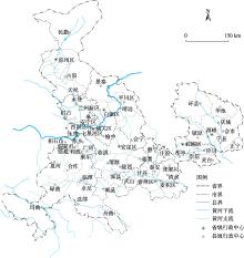
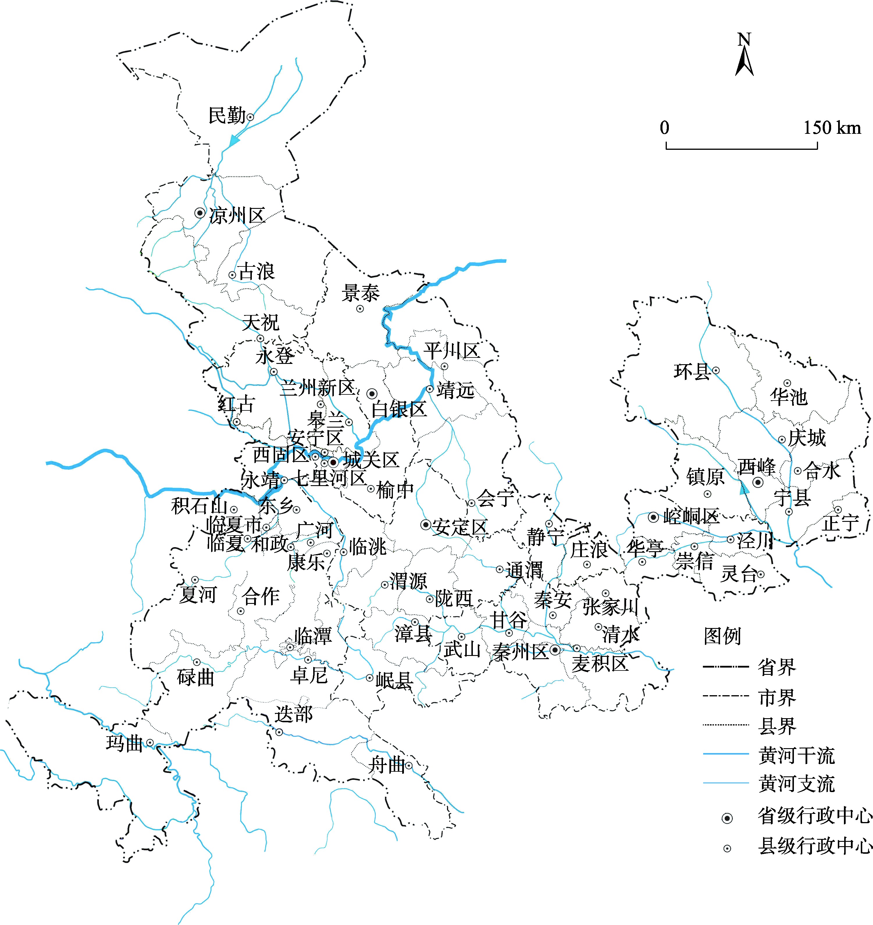
Fig. 1
Scope of the study area"
Tab. 1
Evaluation index system of urban development level"
| 评价指标 | 县城 | 县域 |
|---|---|---|
| 人口-经济 | 城镇常住人口的人均二、三产业产值 | 县域常住人口的人均国内生产总值 |
| 人口-土地 | 单位城镇建成区上的 城镇人口数 | 单位城乡、工矿、居民地上的县域常住人口数 |
| 土地-经济 | 单位城镇建成区上的二、三产业生产总值 | 单位城乡、工矿、居民地上的国内生产总值 |

Fig. 2
Schematic diagram of classification and analysis of urban development tension level"
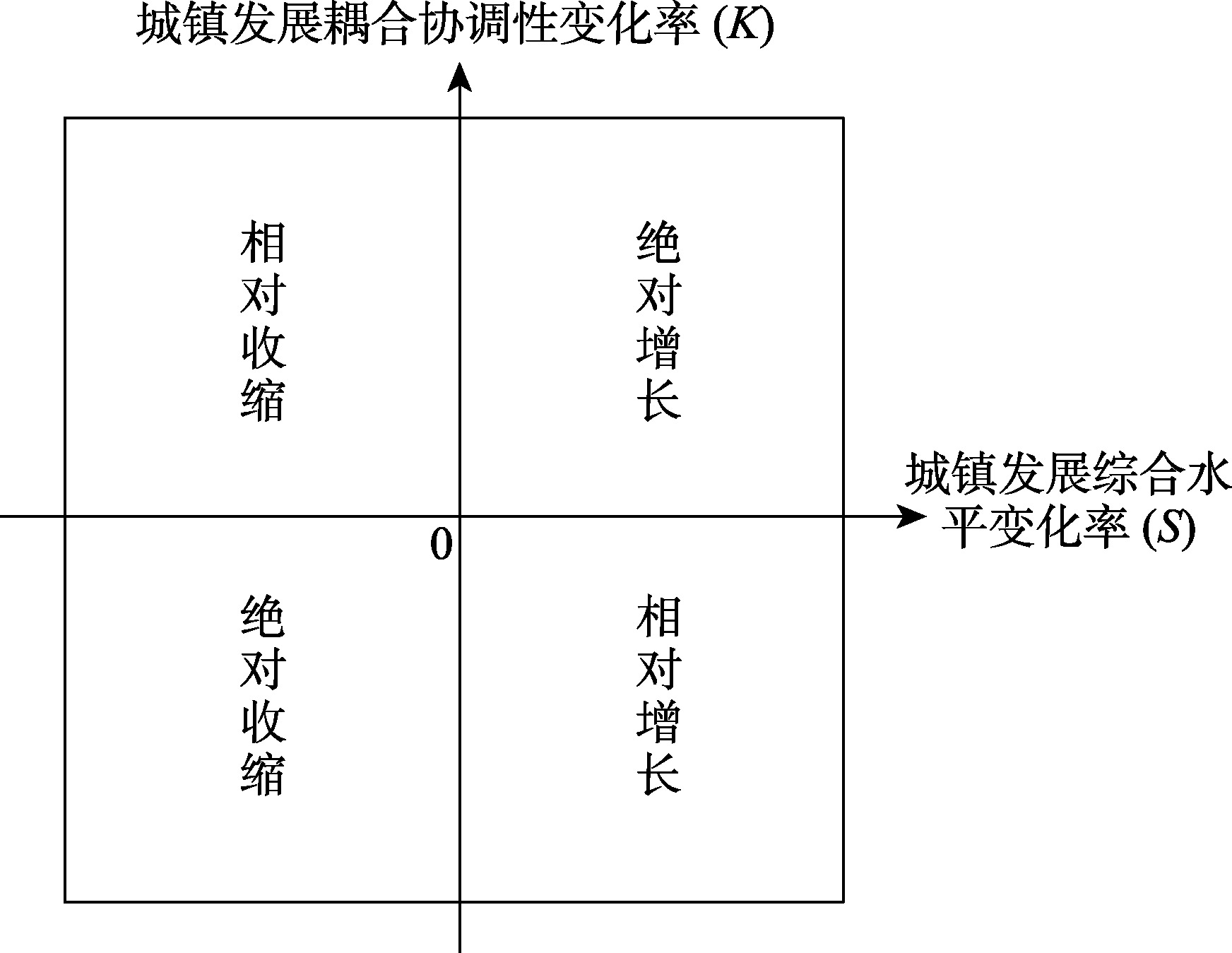
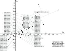
Fig. 3
Variation of comprehensive level of urban development at county-level scale"

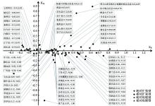
Fig. 4
Discrimination quadrant for urban development contraction types in counties"
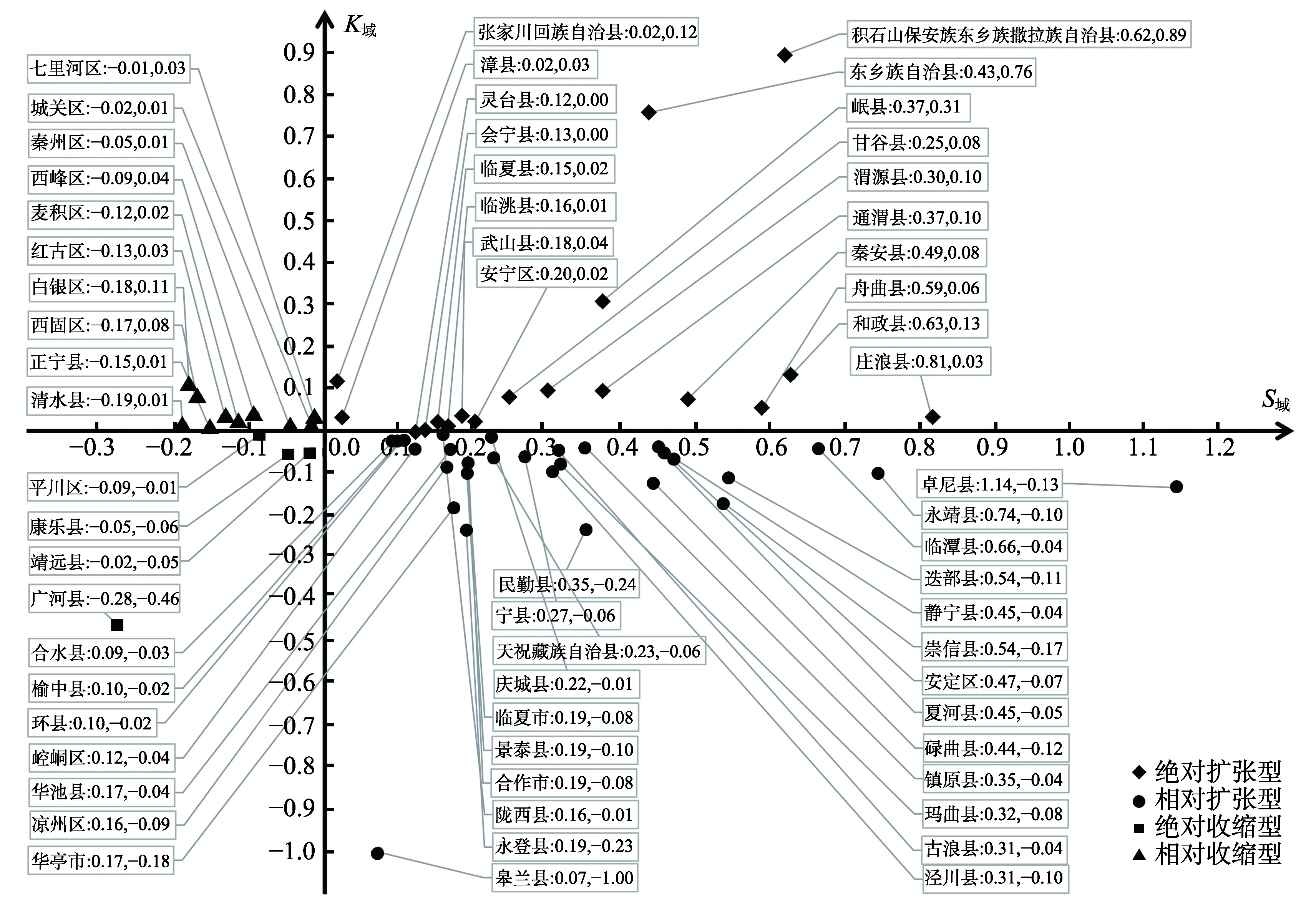
Fig. 5
Discrimination quadrant for urban development contraction types in county towns"

Tab. 2
Influencing factors of comprehensive level of urban development in counties and county towns"
| 类别 | 县域指标 | 代码 | 县城指标 | 代码 |
|---|---|---|---|---|
| 城镇化水平 | 城镇化率的变化量 | 城镇人口数的变化量 | ||
| 经济实力 | GDP总量变化量 | 二三产业产值变化量 | ||
| 人民生活 | 人均GDP变化量 | 城镇人口人均二三产业产值 | ||
| 人均可支配收入变化量 | 人均可支配收入变化量 | |||
| 开发建设 | 县域常住人口人均城镇建设用地面积变化量 | 城镇人口人均城镇建设用地变化量 | ||
| 城镇建成区面积占人类活动实体地域比例的变化量 | 城镇建成区面积变化量 | |||
| 固定资产投资变化量 | 固定资产投资变化量 | |||
| 产业结构 | 第一产业占GDP的比重 | 二、三产业产值占GDP比重 | ||
| 政府活力 | 财政收入变化 | 财政收入变化 | ||
| 财政支出变化 | 财政支出变化 |
Tab. 3
Influencing factors detection results of comprehensive level of urban development in counties"
| 影响因子 | ||||||||||
|---|---|---|---|---|---|---|---|---|---|---|
| 全局 | 0.125** | 0.251*** | 0.538 | 0.224 | 0.046 | 0.084 | 0.247** | 0.152* | 0.132* | 0.046 |
| 收缩 | 0.155 | 0.269 | 0.112 | 0.104 | 0.007 | 0.085 | 0.385 | 0.055 | 0.415 | 0.365 |
| 扩张 | 0.139 | 0.073 | 0.226* | 0.122 | 0.167 | 0.097 | 0.324** | 0.196* | 0.119 | 0.107 |
Tab. 4
Interaction detection results between the dominant factor and other factors in counties"
| 全局(主导因子 | |||||||
|---|---|---|---|---|---|---|---|
| 交互因子 | 作用值 | 交互因子 | 作用值 | 交互因子 | 作用值 | 交互因子 | 作用值 |
| 0.526(a) | 0.417(a) | 0.680(a) | 0.383(b) | ||||
| 0.618(b) | 0.662(b) | 0.399(a) | 0.392(a) | ||||
| 0.408(b) | 0.642(b) | 0.305(a) | 0.333(b) | ||||
| 0.373(a) | 0.671(a) | 0.341(a) | 0.429(a) | ||||
| 0.343(b) | 0.616(b) | 0.520(a) | 0.441(a) | ||||
| 0.596(b) | 0.699(b) | 0.439(a) | 0.472(a) | ||||
| 0.363(b) | 0.658(b) | 0.333(b) | |||||
| 0.441(a) | 0.630(a) | 0.366(a) | |||||
| 收缩(主导因子 | |||||||
| 交互因子 | 作用值 | 交互因子 | 作用值 | 交互因子 | 作用值 | 交互因子 | 作用值 |
| 0.556(a) | 0.963(a) | 0.786(b) | 0.452(b) | ||||
| 0.529(a) | 0.762(a) | 0.777(a) | 0.540(b) | ||||
| 0.416(b) | 0.565(b) | 0.616(b) | 0.667(a) | ||||
| 0.602(a) | 0.483(b) | 0.615(b) | 0.620(a) | ||||
| 0.384(b) | 0.454(b) | 0.630(a) | 0.500(b) | ||||
| 0.884(a) | 0.617(a) | 0.523(b) | 0.800(a) | ||||
| 0.547(a) | 0.811(a) | 0.484(b) | |||||
| 0.626(a) | 0.860(a) | 0.923(a) | |||||
| 扩张(主导因子 | |||||||
| 交互因子 | 作用值 | 交互因子 | 作用值 | 交互因子 | 作用值 | 交互因子 | 作用值 |
| 0.430(a) | 0.486(b) | 0.521(a) | 0.482(a) | ||||
| 0.338(a) | 0.417(b) | 0.452(b) | 0.652(a) | ||||
| 0.399(a) | 0.363(b) | 0.549(b) | |||||
| 0.423(b) | 0.467(a) | 0.480(a) | |||||
| 0.372(a) | 0.520(a) | 0.503(b) | |||||
Tab. 5
Influencing factors detection results of comprehensive level of urban development in county towns"
| 影响因子 | ||||||||||
|---|---|---|---|---|---|---|---|---|---|---|
| 全局 | 0.142 | 0.377*** | 0.630*** | 0.085 | 0.033 | 0.081 | 0.107 | 0.467*** | 0.080 | 0.053 |
| 收缩 | 0.014 | 0.422* | 0.439* | 0.044 | 0.104 | 0.174 | 0.093 | 0.259 | 0.038 | 0.150 |
| 扩张 | 0.152 | 0.067 | 0.443*** | 0.095 | 0.129 | 0.082 | 0.237* | 0.367*** | 0.225* | 0.152 |
Tab. 6
Interaction detection results between the dominant factor and other factors in county towns"
| 全局(主导因子 | |||||||
|---|---|---|---|---|---|---|---|
| 交互因子 | 作用值 | 交互因子 | 作用值 | 交互因子 | 作用值 | 交互因子 | 作用值 |
| 0.517(b) | 0.658(b) | 0.678(b) | 0.716(a) | ||||
| 0.708(b) | 0.515(a) | 0.690(b) | 0.598(a) | ||||
| 0.608(a) | 0.608(a) | 0.803(b) | 0.612(a) | ||||
| 0.678(a) | 0.721(b) | 0.705(b) | 0.608(a) | ||||
| 0.529(a) | 0.674(b) | 0.799(a) | 0.608(a) | ||||
| 0.513(a) | 0.757(a) | 0.702(a) | 0.678(a) | ||||
| 收缩(主导因子 | |||||||
| 交互因子 | 作用值 | 交互因子 | 作用值 | 交互因子 | 作用值 | 交互因子 | 作用值 |
| 0.567(a) | 0.541(b) | 0.731(a) | 0.382(b) | ||||
| 0.736(b) | 0.573(a) | 0.659(a) | 0.523(a) | ||||
| 0.554(a) | 0.608(b) | 0.800(a) | 0.681(a) | ||||
| 0.522(b) | 0.775(a) | 0.655(a) | 0.518(a) | ||||
| 0.781(a) | 0.787(a) | 0.746(a) | 0.348(b) | ||||
| 0.454(b) | 0.606(b) | 0.372(a) | 0.503(a) | ||||
| 扩张(主导因子 | |||||||
| 交互因子 | 作用值 | 交互因子 | 作用值 | 交互因子 | 作用值 | 交互因子 | 作用值 |
| 0.545(b) | 0.719(a) | 0.475(a) | 0.390(a) | ||||
| 0.496(b) | 0.407(b) | 0.591(a) | 0.338(a) | ||||
| 0.492(b) | 0.404(a) | 0.461(b) | 0.344(b) | ||||
| 0.618(a) | 0.573(b) | 0.654(b) | 0.465(a) | ||||
| 0.515(b) | 0.434(b) | 0.568(b) | 0.327(b) | ||||
| 0.543(b) | 0.332(b) | 0.531(b) | 0.510(a) | ||||
| 0.672(b) | 0.574(b) | 0.571(b) | |||||
| 0.580(b) | 0.586(a) | 0.711(a) | |||||
| [1] |
赵德昭, 许家伟. 河南省县域就地城镇化时空演变与影响机理研究[J]. 地理研究, 2021, 40(7): 1978-1992.
doi: 10.11821/dlyj020200698 |
|
[ Zhao Dezhao, Xu Jiawei. Study on spatio-temporal evolution and influence mechanism of in situ urbanization at the county level in Henan Province[J]. Geographical Research, 2021, 40(7): 1978-1992. ]
doi: 10.11821/dlyj020200698 |
|
| [2] | 任志安, 郭枫玥. 就业结构、产业结构与就地城镇化[J]. 城市学刊, 2017, 38(1): 1-11. |
| [ Ren Zhi’an, Guo Fengyue. Employment structure, industrial structure and local urbanization[J]. Urban Studies, 2017, 38(1): 1-11. ] | |
| [3] | 石建勋, 邓嘉纬, 辛沛远. 以县城为重要载体推动新型城镇现代化建设的内涵、特点、价值意蕴及实施路径[J]. 新疆师范大学学报(哲学社会科学版), 2022, 43(5): 1-10. |
| [ Shi Jianxun, Deng Jiawei, Xin Peiyuan. The connotation, characteristics, value implications and implementation paths of promoting the modernization of new cities and towns with counties as important carriers[J]. Journal of Xinjiang Normal University (Philosophy and Social Sciences Edition), 2022, 43(5): 1-10. ] | |
| [4] | 张凤林. 全面推进乡村振兴背景下县域经济高质量发展研究[J]. 理论探讨, 2022, 39(3): 167-172. |
| [ Zhang Fenglin. Research on high-quality development of county economy under the background of comprehensively promoting rural revitalization[J]. Theoretical Discussions, 2022, 39(3): 167-172. ] | |
| [5] |
尹君锋, 石培基, 张韦萍, 等. 乡村振兴背景下县域农业农村创新发展评价及空间格局——以甘肃省为例[J]. 自然资源学报, 2022, 37(2): 291-306.
doi: 10.31497/zrzyxb.20220202 |
|
[ Yin Junfeng, Shi Peiji, Zhang Weiping, et al. Evaluation and spatial pattern of county-level agricultural and rural innovation and development under the background of rural revitalization: A case study of Gansu Province[J]. Journal of Natural Resources, 2022, 37(2): 291-306. ]
doi: 10.31497/zrzyxb.20220202 |
|
| [6] | Albecker M F, Fol S. The restructuring of declining suburbs in the paris region[C]//Pallagst K, Wiechmann T, Fernandez C M. Shrinking cities. London: Routledge, 2014: 78-98. |
| [7] | 徐博, 庞德良. 增长与衰退: 国际城市收缩问题研究及对中国的启示[J]. 经济学家, 2014, 34(4): 5-13. |
| [ Xu Bo, Pang Deliang. Growth and decline: A study on the problem of international urban contraction and its implications for China[J]. Economist, 2014, 34(4): 5-13. ] | |
| [8] | 刘合林. 收缩城市量化计算方法进展[J]. 现代城市研究, 2016, 37(2): 17-22. |
| [ Liu Helin. Progress in quantitative calculation methods for shrinking cities[J]. Modern Urban Studies, 2016, 37(2): 17-22. ] | |
| [9] | Häußermann H, Siebel W. Die schrumpfende stadt und die stadtsoziologie[J]. Kölner Zietschrift für Soziologie und Sozialpsychologie, 1988, 29: 78-94. |
| [10] |
Wiechmann T. Errors expected-aligning urban strategy with demographic uncertainty in shrinking cities[J]. International Planning Studies, 2008, 13(4): 431-446.
doi: 10.1080/13563470802519097 |
| [11] | 李郇, 杜志威, 李先锋. 珠江三角洲城镇收缩的空间分布与机制[J]. 现代城市研究, 2015, 36(9): 36-43. |
| [ Li Xun, Du Zhiwei, Li Xianfeng. Spatial distribution and mechanism of urban contraction in the Pearl River Delta[J]. Modern Urban Studies, 2015, 36(9): 36-43. ] | |
| [12] | 龙瀛, 吴康, 王江浩. 中国收缩城市及其研究框架[J]. 现代城市研究, 2015, 36(9): 14-19. |
| [ Long Ying, Wu Kang, Wang Jianghao. Shrinking cities in China and its research framework[J]. Modern Urban Studies, 2015, 36(9): 14-19. ] | |
| [13] |
Lange D A. Polluted and dangerous: America’s worst abandoned properties and what can be done about them[J]. Journal of the American Planning Association, 2009, 75(4): 498-499.
doi: 10.1080/01944360903169675 |
| [14] | Pallagst K. The interdependence of shrinking and growing: Processes of urban transformation in the US in the rust belt and beyond[C]//Pallagst K, Wiechmann T, Martinez-Fernandez C. Shrinking cities:International perspectives and policy implications. London: Routledge, 2014: 59-93. |
| [15] | 张京祥, 冯灿芳, 陈浩. 城市收缩的国际研究与中国本土化探索[J]. 国际城市规划, 2017, 32(5): 1-9. |
| [ Zhang Jingxiang, Feng Canfang, Chen Hao. International research on urban contraction and exploration of Chinese localization[J]. International Urban Planning, 2017, 32(5): 1-9. ] | |
| [16] | 李智, 龙瀛. 基于动态街景图片识别的收缩城市街道空间品质变化分析: 以齐齐哈尔为例[J]. 城市建筑, 2018, 15(6): 21-25. |
| [ Li Zhi, Long Ying. Analysis of spatial quality change of shrinking urban streets based on dynamic streetscape picture recognition: A case study of Qiqihar[J]. Urban Architecture, 2018, 15(6): 21-25. ] | |
| [17] |
吴康, 戚伟. 收缩型城市: 认知误区、统计甄别与测算反思[J]. 地理研究, 2021, 40(1): 213-229.
doi: 10.11821/dlyj020200359 |
|
[ Wu Kang, Qi Wei. Shrinking cities: Cognitive misunderstandings, statistical screening and measurement reflection[J]. Geographical Research, 2021, 40(1): 213-229. ]
doi: 10.11821/dlyj020200359 |
|
| [18] | 陆荫, 张强, 李晓红, 等. 黄河流域甘肃段植被覆盖度时空变化及对气候因子的响应[J]. 水土保持通报, 2020, 40(2): 232-238. |
| [ Lu Yin, Zhang Qiang, Li Xiaohong, et al. Temporal and spatial variation of vegetation cover in Gansu section of the Yellow River Basin and its response to climatic factors[J]. Bulletin of Soil and Water Conservation, 2020, 40(2): 232-238. ] | |
| [19] | 徐新良, 刘纪远, 张树文, 等. 中国多时期土地利用土地覆被遥感监测数据集(CNLUCC)[DB/OL]. [2022-03-30]. 中国科学院资源环境科学数据中心数据注册与出版系统.https://www.resdc.cn/DOI/DOI.aspx?DOIID=54. |
| [Xu Xinliang, Liu Jiyuan, Zhang Shuwen, et al. Remote sensing monitoring dataset of land cover for land use in multiple periods of China (CNLUCC)[DB/OL]. [2022-03-30]. Data Registration and Publication System of Data Center of Resources and Environmental Sciences, Chinese Academy of Sciences. https://www.resdc.cn/DOI/DOI.aspx?DOIID=54. ] | |
| [20] | 范擎宇. 协调视角下长三角城市群空间结构演变及机理研究[D]. 南京: 南京师范大学, 2020. |
| [ Fan Qingyu. Spatial structure evolution and mechanism of Yangtze River Delta urban agglomeration from the perspective of coordination[D]. Nanjing: Nanjing Normal University, 2020. ] | |
| [21] | 曹文莉, 张小林, 潘义勇, 等. 发达地区人口、土地与经济城镇化协调发展度研究[J]. 中国人口·资源与环境, 2012, 22(2): 141-146. |
| [ Cao Wenli, Zhang Xiaolin, Pan Yiyong, et al. Research on the coordinated development degree of population, land and economic urbanization in developed areas[J]. Chinese, Resources and Environment, 2012, 22(2): 141-146. ] | |
| [22] |
贺三维, 邵玺. 京津冀地区人口-土地-经济城镇化空间集聚及耦合协调发展研究[J]. 经济地理, 2018, 38(1): 95-102.
doi: 10.2307/142270 |
|
[ He Sanwei, Shao Xi. Research on spatial agglomeration and coupled coordinated development of population-land-economic urbanization in Beijing-Tianjin-Hebei Region[J]. Economic Geography, 2018, 38(1): 95-102. ]
doi: 10.2307/142270 |
|
| [23] |
麻学锋, 吕逸翔. 张家界城镇居民幸福水平对旅游城镇化集聚的响应识别及测度[J]. 自然资源学报, 2020, 35(7): 1647-1658.
doi: 10.31497/zrzyxb.20200710 |
|
[ Ma Xuefeng, Lü Yixiang. Recognition and measurement of the response of urban residents’ happiness level to tourism urban agglomeration in Zhangjiajie[J]. Journal of Natural Resources, 2020, 35(7): 1647-1658. ]
doi: 10.31497/zrzyxb.20200710 |
|
| [24] |
孟祥凤, 马爽, 项雯怡, 等. 基于百度慧眼的中国收缩城市分类研究[J]. 地理学报, 2021, 76(10): 2477-2488.
doi: 10.11821/dlxb202110010 |
|
[ Meng Xiangfeng, Ma Shuang, Xiang Wenyi, et al. Classification of shrinking cities in China based on Baidu Insight[J]. Acta Geographical Sinica, 2021, 76(10): 2477-2488. ]
doi: 10.11821/dlxb202110010 |
|
| [25] |
王劲峰, 徐成东. 地理探测器:原理与展望[J]. 地理学报, 2017, 72(1): 116-134.
doi: 10.11821/dlxb201701010 |
|
[ Wang Jinfeng, Xu Chengdong. Geographical detectors: Principles and prospects[J]. Acta Geographical Sinica, 2017, 72(1): 116-134. ]
doi: 10.11821/dlxb201701010 |
|
| [26] | 周恺, 钱芳芳. 收缩城市: 逆增长情景下的城市发展路径研究进展[J]. 现代城市研究, 2015, 36(9): 2-13. |
| [ Zhou Kai, Qian Fangfang. Shrinking cities: Research progress on urban development pathways under the scenario of inverse growth[J]. Modern Urban Studies, 2015, 36(9): 2-13. ] | |
| [27] | 吴康, 龙瀛, 杨宇. 京津冀与长江三角洲的局部收缩: 格局、类型与影响因子识别[J]. 现代城市研究, 2015, 36(9): 26-35. |
| [ Wu Kang, Long Ying, Yang Yu. Local contraction of Beijing-Tianjin-Hebei and Yangtze River Delta: Identification of pattern, type and impact factor[J]. Modern Urban Studies, 2015, 36(9): 26-35. ] | |
| [28] | 张瑞, 李朝奎, 姚思妤, 等. 融合地理探测器和地理加权回归的太原市建设用地变化因子研究[J]. 测绘通报, 2022, 68(5): 106-109, 119. |
| [ Zhang Rui, Li Chaokui, Yao Siyu, et al. Study on the variation factor of construction land in Taiyuan City by integrating geographic detectors and geographical weighted regression[J]. Bulletin of Surveying and Mapping, 2022, 68(5): 106-109, 119. ] | |
| [29] | 杜传忠, 侯佳妮. “去工业化”对中国地区经济增长的影响——基于门槛效应的分析[J]. 现代财经, 2021, 41(9): 3-19. |
| [ Du Chuanzhong, Hou Jiani. The impact of “deindustrialization” on China’s regional economic growth: An analysis based on threshold effect[J]. Modern Finance, 2021, 41(9): 3-19. ] |
| [1] | DONG Xiaoyuan, XU Deze, SHI Xiaobin, DU Sen. Ecological sensitivity evaluation of the Gansu section of the Yellow River: A case study of Guanghe County [J]. Arid Land Geography, 2024, 47(4): 599-611. |
| [2] | ZHANG Zhongfu. Spatial division and sustainable development and utilization strategy of geological relics in Gansu section of the Yellow River Basin [J]. Arid Land Geography, 2022, 45(4): 1235-1243. |
|
||