干旱区地理 ›› 2025, Vol. 48 ›› Issue (8): 1374-1384.doi: 10.12118/j.issn.1000-6060.2024.582 cstr: 32274.14.ALG2024582
张可心( ), 赵玉娟, 李美瑜
收稿日期:2024-09-27
修回日期:2024-12-19
出版日期:2025-08-25
发布日期:2025-08-21
作者简介:张可心(1995-),女,工程师,主要从事中短期天气预报及气候变化研究. E-mail: 18893420889@139.com
基金资助:
ZHANG Kexin(), ZHAO Yujuan, LI Meiyu
Received:2024-09-27
Revised:2024-12-19
Published:2025-08-25
Online:2025-08-21
摘要: 冰雹是强对流引起的极端天气之一,发展速度快,危害性大,尤其是对农业经济为主体的陇东地区具有极大的威胁。在气候变暖背景下,有必要深入研究陇东冰雹气候特征及其影响因素。利用1978—2023年陇东地区15个县区地面观测站记录的冰雹数据和灾情资料,结合ECMWF提供的ERA5再分析资料,利用线性倾向估计、Mann-Kendall突变检验、Morlet小波分析法等方法分析了陇东地区冰雹时空分布特征及关键影响因素。结果表明:(1)陇东地区冰雹日数空间分布不均匀,呈现西北、东南多,中部、南部少的特征,多雹区主要位于下坡地形、山脉背风坡及子午岭山区,少雹区主要位于平坦的塬区及六盘山南部。(2)近46 a冰雹日数呈减少趋势,且春季减少趋势最显著;5—8月为冰雹高发期,占全年冰雹日数的81.5%。(3)冰雹日变化呈现“单峰型”特征,15:00—18:00为冰雹多发时段;持续时间0~9 min及直径中等的降雹频率最高;局地性冰雹频率远高于区域性冰雹,但区域性冰雹具有显著增加趋势。(4)冰雹日数存在3 a的主震荡周期以及14 a、35 a的次震荡周期。(5)不同季节影响冰雹日数的主导气象因素不同,对流有效位能(CAPE)、0 ℃层高度对陇东冰雹日数最具有主导作用。研究结果可认识陇东冰雹发生规律,为优化预报预警模型和人工防雹工作提供科学参考。
张可心, 赵玉娟, 李美瑜. 1978—2023年陇东冰雹气候特征及其影响因素分析[J]. 干旱区地理, 2025, 48(8): 1374-1384.
ZHANG Kexin, ZHAO Yujuan, LI Meiyu. Hail climate characteristics and influencing factors in eastern Gansu Province from 1978 to 2023[J]. Arid Land Geography, 2025, 48(8): 1374-1384.
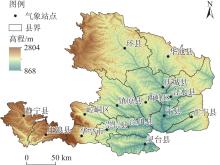
图1
研究区示意图 注:基于自然资源部标准地图服务网站审图号为GS(2019)3082号的标准地图制作,底图边界无修改。下同。"

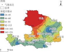
图2
1978—2023年陇东地区冰雹日数空间分布"
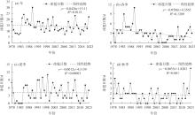
图3
1978—2023年陇东地区冰雹日数年际变化"
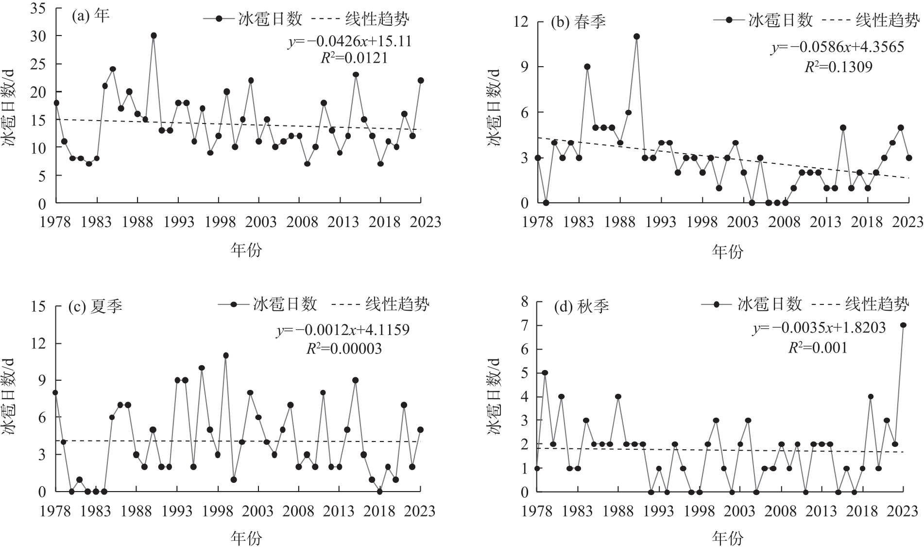
图4
1978—2023年陇东地区冰雹日数年际变化Mann-Kendall突变检验 注:UF为顺序统计量;UB为逆序统计量。"

图5
1978—2023年陇东地区冰雹频率月际变化"
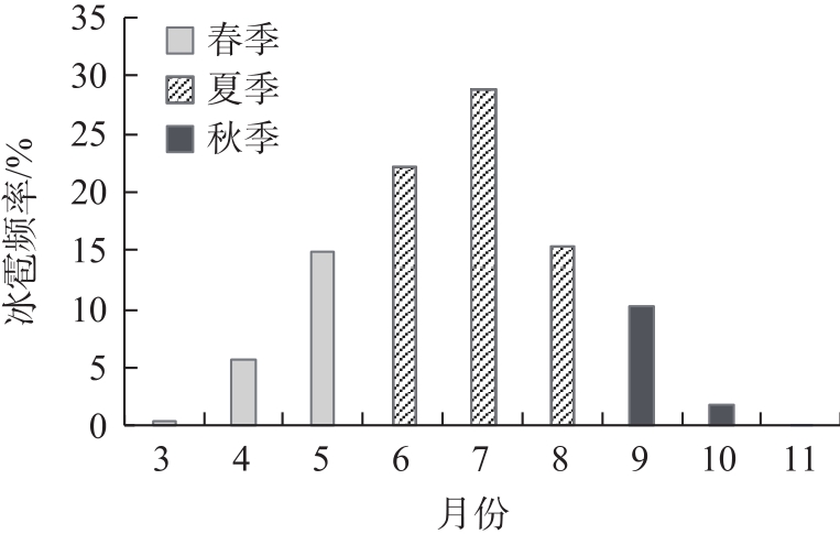
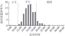
图6
1978—2023年陇东地区冰雹日变化"
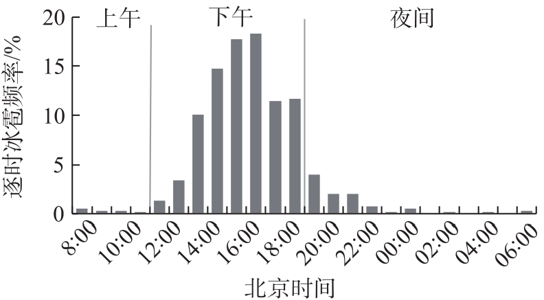

图7
1978—2023年陇东地区一次冰雹持续时间频率分布"
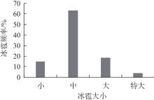
图8
1978—2023年陇东地区不同直径冰雹发生频率分布"
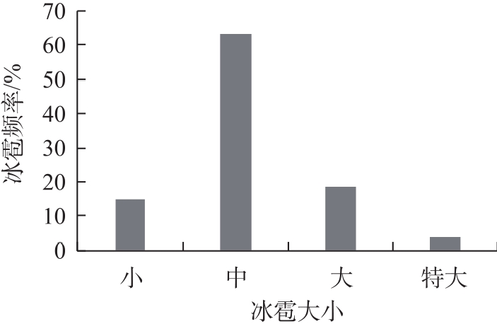
图9
1978—2023年陇东地区局地性、区域性冰雹的月际及年际分布"
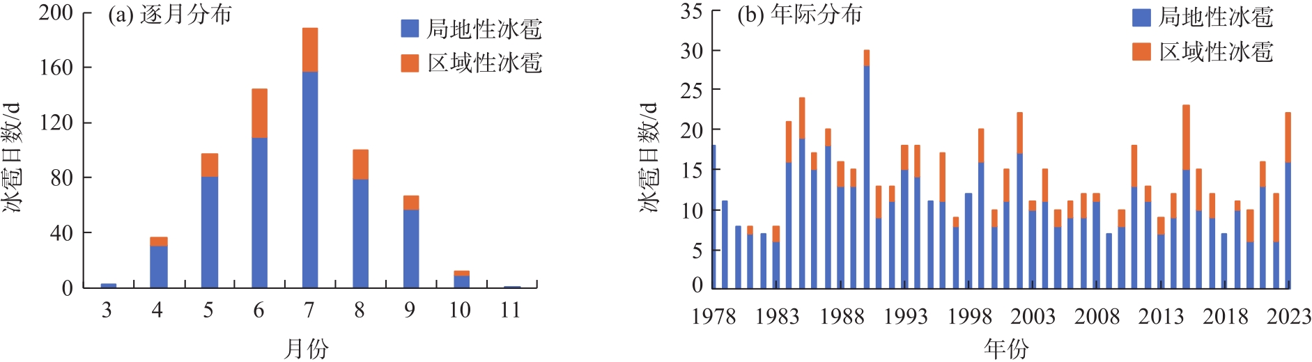
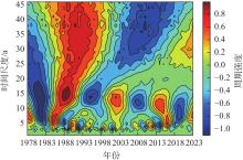
图10
1978—2023年陇东地区冰雹日数周期变化"

表1
近46 a大气物理参数与陇东冰雹日数的相关性分析"
| 大气物理参数 | 春季 | 夏季 | 秋季 |
|---|---|---|---|
| 2 m气温/K | -0.440** | -0.031 | -0.121 |
| 2 m露点温度/K | 0.360* | -0.038 | -0.142 |
| 对流有效位能(CAPE)/J·kg-1 | 0.554*** | 0.169 | 0.480*** |
| 云底高度/m | -0.457** | 0.113 | 0.069 |
| 对流性降水/mm | 0.316* | -0.005 | 0.026 |
| K指数/℃ | 0.393** | 0.155 | -0.152 |
| 总降水量/mm | 0.346* | -0.164 | -0.090 |
| 0 ℃层高度/m | -0.305* | -0.291* | -0.209 |
| [1] | 孙继松. 强对流天气预报的基本原理与技术方法[M]. 北京: 气象出版社, 2014: 3-6. |
| [Sun Jisong. Fundamental principles and technical methods for severe convective weather forecasting[M]. Beijing: China Meteorological Press, 2014: 3-6. ] | |
| [2] | 张强. 中国西北冰雹研究[M]. 北京: 气象出版社, 2005: 56-68. |
| [Zhang Qiang. Research on hail in northwest China[M]. Beijing: China Meteorological Press, 2005: 56-68. ] | |
| [3] | 俞小鼎, 王秀明, 李万莉, 等. 雷暴与强对流临近预报[M]. 北京: 气象出版社, 2020: 65-75. |
| [YuXiaoding, WangXiuming, LiWanli, et al. Nowcasting of thunderstorms and severe convective weather[M]. Beijing: China Meteorological Press, 2020: 65-75. ] | |
| [4] | Kang F, Zhang Q, Lu S. Validation and development of a new hailstone formation theory: Numerical simulations of a strong hailstorm occurring over the Qinghai-Tibetan Plateau[J]. Journal of Geophysical Research: Atmospheres, 2007, 112(d2): 1-13. |
| [5] | Punge H, Kunz M. Hail observations and hailstorm characteristics in Europe: A review[J]. Atmospheric Research, 2016(1): 176-177. |
| [6] | 赵文慧, 姚展予, 贾烁, 等. 1961—2015年中国地区冰雹持续时间的时空分布特征及影响因子研究[J]. 大气科学, 2019, 43(3): 539-551. |
| [Zhao Wenhui, Yao Zhanyu, Jia Shuo, et al. Characteristics of spatial and temporal distribution of hail duration in China during 1961—2015 and its possible influence factors[J]. Chinese Journal of Atmospheric Sciences, 2019, 43(3): 539-551. ] | |
| [7] |
辛悦, 苏立娟, 郑旭程, 等. 内蒙古冰雹特征及基于机器学习的冰雹识别方法研究[J]. 干旱区地理, 2025, 48(1): 11-19.
doi: 10.12118/j.issn.1000-6060.2024.057 |
|
[Xin Yue, Su Lijuan, Zheng Xucheng, et al. Hail characteristics and hail recognition method based on machine learning in Inner Mongolia[J]. Arid Land Geography, 2025, 48(1): 11-19. ]
doi: 10.12118/j.issn.1000-6060.2024.057 |
|
| [8] |
马荣君, 李潇斐, 毛彦霖, 等. 陕西省冰雹气候变化特征及其关键影响因素分析[J]. 干旱区研究, 2022, 39(3): 767-773.
doi: 10.13866/j.azr.2022.03.10 |
|
[Ma Rongjun, Li Xiaofei, Mao Yanlin, et al. Characteristics and causes of climate change in hail in occurrence Shaanxi Province[J]. Arid Zone Research, 2022, 39(3): 767-773. ]
doi: 10.13866/j.azr.2022.03.10 |
|
| [9] | Kunz M, Sander J, Kottmeier C. Recent trends of thunderstorm and hailstorm frequency and their relation to atmospheric characteristics in southwest Germany[J]. International Journal of Climatology: A Journal of the Royal Meteorological Society, 2009, 29(15): 2283-2297. |
| [10] | Li M X, Zhang Q H, Zhang F Q. Hail day frequency trends and associated atmospheric circulation patterns over China during 1960—2012[J]. Journal of Climate, 2016, 29: 7027-7044. |
| [11] | Zhang C, Zhang Q, Wang Y. Climatology of hail in China: 1961—2005[J]. Journal of Applied Meteorology & Climatology, 2008, 47(3): 795-804. |
| [12] | 冯晓莉, 马占良, 管琴, 等. 1980—2018年青海高原冰雹分布特征及其关键影响因素分析[J]. 气象, 2021, 47(6): 717-726. |
| [Feng Xiaoli, Ma Zhanliang, Guan Qin, et al. Spatio-temporal characteristics of hail and its influence factors in Qinghai Plateau during 1980—2018[J]. Meteorological Monthly, 2021, 47(6): 717-726. ] | |
| [13] | 于怀征, 龚佃利, 朱秀红, 等. 山东冰雹时空分布特征与分类预报指标研究[J]. 气象科技, 2023, 51(2): 254-261. |
| [Yu Huaizheng, Long Dianli, Zhu Xiuhong, et al. Analysis of spatial-temporal distribution characteristics of hails in Shandong Province and classified forecast indexes[J]. Meteorological Science and Technology, 2023, 51(2): 254-261. ] | |
| [14] | 刘涛, 夏晓玲, 彭宇翔, 等. 贵州省61年冰雹气候特征及其成因分析[J]. 热带气象学报, 2023, 39(6): 872-882. |
| [Liu Tao, Xia Xiaoling, Peng Yuxiang, et al. Climatic characteristic and causes of hail in Guizhou: 1961—2021[J]. Journal of Tropical Meteorology, 2023, 39(6): 872-882. ] | |
| [15] | 杨丽杰, 程鹏, 刘翔, 等. 1970—2019年陇东地区强对流天气的气候特征分析[J]. 沙漠与绿洲气象, 2023, 17(1): 25-31. |
| [Yang Lijie, Cheng Peng, Liu Xiang, et al. Analysis of climatic characteristics of severe convective weather in Longdong Area in recent 50 years[J]. Desert and Oasis Meteorology, 2023, 17(1): 25-31. ] | |
| [16] | 孙旭映. 甘肃省冰雹天气形成机理、特征及雷达识别技术研究[D]. 南京: 南京信息工程大学, 2007. |
| [Sun Xuying. Research on formation mechanism, characteristics and radar recognition technology of hail weather in Gansu Province[D]. Nanjing: Nanjing University of Information Science and Technology, 2007. ] | |
| [17] | 路亚奇, 焦美龄, 李祥科, 等. 陇东短时强降水与冰雹天气对比分析及预报方法研究[J]. 干旱区地理, 2016, 39(2): 317-326. |
| [Lu Yaqi, Jiao Meiling, Li Xiangke, et al. Comparative analysis and prediction method of short time heavy precipitation and hail weather in eastern Gansu Province[J]. Arid Land Geography, 2016, 39(2): 317-326. ] | |
| [18] |
路亚奇, 曹彦超, 张峰, 等. 陇东冰雹天气特征分析及预报预警[J]. 高原气象, 2016, 35(6): 1565-1576.
doi: 10.7522/j.issn.1000-0534.2015.00116 |
|
[Lu Yaqi, Cao Yanchao, Zhang Feng, et al. The prediction and forewarning system as well as weather characteristics analyses of hail in the east of Gansu[J]. Plateau Meteorology, 2016, 35(6): 1565-1576. ]
doi: 10.7522/j.issn.1000-0534.2015.00116 |
|
| [19] |
雷瑜, 黄武斌, 黎倩, 等. 不同天气分型下甘肃河东地区强冰雹天气多普勒雷达产品特征[J]. 干旱气象, 2022, 40(2): 234-243.
doi: 10.11755/j.issn.1006-7639(2022)-02-0234 |
| [Lei Yu, Huang Wubin, Li Qian, et al. Characteristics of Doppler radar products of strong hails under different weather classification in Hedong region of Gansu Province[J]. Journal of Arid Meteorology, 2022, 40(2): 234-243. ] | |
| [20] | 吴爱敏, 张天锋, 白爱军. 陇东黄土高原冰雹的气候特征及预报[J]. 灾害学, 2005, 20(2): 37-40. |
| [Wu Aimin, Zhang Tianfeng, Bai Aijun. Climatic characteristics and forecast of hail on the Loess Plateau of eastern Gansu[J]. Journal of Catastrophology, 2005, 20(2): 37-40. ] | |
| [21] | 王若升, 张彤, 樊晓春, 等. 甘肃平凉地区冰雹天气的气候特征和雷达回波分析[J]. 干旱气象, 2013, 31(2): 373-377. |
| [Wang Ruosheng, Zhang Tong, Fan Xiaochun, et al. Analysis of the climate features and radar echo of the hail weather in Pingliang of Gansu Province[J]. Journal of Arid Meteorology, 2013, 31(2): 373-377. ] | |
| [22] | 张强, 杨金虎, 王朋岭, 等. 西北地区气候暖湿化的研究进展与展望[J]. 科学通报, 2023, 68(14): 1814-1828. |
| [Zhang Qiang, Yang Jinhu, Wang Pengling, et al. Progress and prospect on climate warming and humidification in northwest China[J]. Chinese Science Bulletin, 2023, 68(14): 1814-1828. ] | |
| [23] |
丁一汇, 柳艳菊, 徐影, 等. 全球气候变化的区域响应: 中国西北地区气候“暖湿化”趋势、成因及预估研究进展与展望[J]. 地球科学进展, 2023, 38(6): 551-562.
doi: 10.11867/j.issn.1001-8166.2023.027 |
|
[Ding Yihui, Liu Yanju, Xu Ying, et al. Regional responses to global climate change: Progress and prospects for trend, causes, and projection of climatic warming-wetting in northwest China[J]. Advances in Earth Science, 2023, 38(6): 551-562. ]
doi: 10.11867/j.issn.1001-8166.2023.027 |
|
| [24] | 李栋梁, 刘德祥. 甘肃气候[M]. 北京: 气象出版社, 2000: 41-56. |
| [Li Dongliang, Liu Dexiang. Gansu climate[M]. Beijing: China Meteorological Press, 2000: 41-56. ] | |
| [25] | 黄玉霞, 王宝鉴, 王研峰, 等. 1974—2013年甘肃冰雹日数的变化特征[J]. 气象, 2017, 43(4): 450-459. |
| [Huang Yuxia, Wang Baojian, Wang Yanfeng, et al. Variation characteristics of hail days in Gansu Province during 1974—2013[J]. Meteorlogical Monthly, 2017, 43(4): 450-459. ] | |
| [26] |
唐延东, 臧翠萍, 于云鹏, 等. 基于分形理论的陇东地区沟谷发育特征及影响因素分析[J]. 干旱区地理, 2025, 48(2): 223-233.
doi: 10.12118/j.issn.1000-6060.2024.262 |
|
[Tang Yandong, Zang Cuiping, Yu Yunpeng, et al. Developmental characteristics and influencing factors of gullies based on fractal theory in eastern Gansu Province[J]. Arid Land Geography, 2025, 48(2): 223-233. ]
doi: 10.12118/j.issn.1000-6060.2024.262 |
|
| [27] | 黄玥, 孙建华, 张元春, 等. 华北地区暖季雷暴大风对流系统的触发、组织类型及环境条件[J]. 中国科学: 地球科学, 2024, 54(9): 2929-2947. |
| [Huang Yue, Sun Jianhua, Zhang Yuanchun, et al. Initiation, organizational modes and environmental conditions of severe convective wind events during the warm season over north China[J]. Science China: Earth Sciences, 2024, 54(9): 2929-2947. ] | |
| [28] |
衣娜娜, 苏立娟, 郑旭程, 等. 冰雹天气的环境参量及预报模型[J]. 干旱区研究, 2024, 41(1): 13-23.
doi: 10.13866/j.azr.2024.01.02 |
|
[Yi Nana, Su Lijuan, Zheng Xucheng, et al. Environmental parameters and forecast models of hail events[J]. Arid Zone Research, 2024, 41(1): 13-23. ]
doi: 10.13866/j.azr.2024.01.02 |
|
| [29] |
张海耀, 黄玉霞, 吴辉彦, 等. 黄土高原复杂地形区两次冰雹天气过程对比分析[J]. 干旱气象, 2022, 40(4): 646-655.
doi: 10.11755/j.issn.1006-7639(2022)-04-0646 |
| [Zhang Haiyao, Huang Yuxia, Wu Huiyan, et al. Comparative analysis of two consecutive hail weathers in complex terrain area of Loess Plateau[J]. Journal of Arid Meteorology, 2022, 40(4): 646-655. ] | |
| [30] | 王子昕. 多源数据融合算法在一次强对流天气过程中的应用[D]. 南京: 南京信息工程大学, 2021. |
| [Wang Zixin. Application of multi-source data fusion algorithm in a severe convective weather process[D]. Nanjing: Nanjing University of Information Science and Technology, 2021. ] | |
| [31] | 张芳华, 高辉. 中国冰雹日数的时空分布特征[J]. 南京气象学院学报, 2008, 31(5): 687-693. |
| [Zhang Fanghua, Gao Hui. Temproal and spatial features of hail days in China[J]. Journal of Nanjing Institute of Meteorology, 2008, 31(5): 687-693. ] | |
| [32] | 国家气象中心. 冰雹等级GB/T 27957-2011[S]. 北京: 中国标准出版社, 2011: 3-6. |
| [National Meteorological Center. Hail grade GB/T 27957-2011[S]. Beijing: Standards Press of China, 2011: 3-6. ] | |
| [33] | 张鸿发, 龚乃虎, 贾伟, 等. 平凉地区强对流钩状回波特征的观测研究[J]. 大气科学, 1997, 21(4): 18-29. |
| [Zhang Hongfa, Gong Naihu, Jia Wei, et al. Observational investigation of characteristics of severe convective hook echo in Pingliang region[J]. Chinese Journal of Atmospheric Sciences, 1997, 21(4): 18-29. ] | |
| [34] | 仇莉, 姜宗祖, 王凌军, 等. 延安沟壑区冰雹灾害特征及影响路径研究[J]. 农业灾害研究, 2023, 13(3): 184-186. |
| [Qiu Li, Jiang Zongzu, Wang Lingjun, et al. Study on characteristics and influence path of hail disaster in Yan’an gully region[J]. Agricultural Disaster Research, 2023, 13(3): 184-186. ] | |
| [35] |
周嵬, 张强, 康凤琴. 我国西北地区降雹气候特征及若干研究进展[J]. 地球科学进展, 2005, 20(9): 1029-1036.
doi: 10.11867/j.issn.1001-8166.2005.09.1029 |
| [Zhou Wei, Zhang Qiang, Kang Fengqin. Recent advancements of hail research in northwest China[J]. Advances in Earth Science, 2005, 20(9): 1029-1036. ] | |
| [36] | 郭海英, 张谋草, 周忠文, 等. 气候暖湿化及其对陇东冬小麦生产的影响[J]. 中国农学通, 2023, 39(15): 127-131. |
|
[Guo Haiying, Zhang Moucao, Zhou Zhongwen, et al. The impact of warming and wetting of climate on production of winter wheat in eastern Gansu Province[J]. Chinese Agricultural Science Bulletin, 2023, 39(15): 127-131. ]
doi: 10.11924/j.issn.1000-6850.casb2022-0395 |
|
| [37] | 王芝兰, 陈录元, 尚可政, 等. 青海强对流天气时空特征及其对气候变暖的响应[J]. 干旱气象, 2011, 29(4): 439-445, 454. |
| [Wang Zhilan, Chen Luyuan, Shang Kezheng, et al. Characteristics of temporal and spatial distribution of severe convective weather and its response to climate warming in Qinghai Province[J]. Journal of Arid Meteorology, 2011, 29(4): 439-445, 454. ] | |
| [38] | 隋玉秀, 杨景泰, 李昱茜, 等. 1971—2018年大连地区冰雹气候特征[J]. 干旱气象, 2020, 38(2): 249-255. |
| [Sui Yuxiu, Yang Jingtai, Li Yuqian, et al. Climatic characteristics of hails in Dalian region of Liaoning Province from 1971 to 2018[J]. Journal of Arid Meteorology, 2020, 38(2): 249-255. ] | |
| [39] | 温克刚. 中国气象灾害大典: 甘肃卷[M]. 北京: 气象出版社, 2005: 169-197. |
| [Wen Kegang. China meteorological disaster encyclopedia: Gansu[M]. Beijing: China Meteorological Press, 2005: 169-197. ] | |
| [40] | 曹彦超, 韩晶, 路亚奇, 等. 陇东两类夏季雷暴的活动特征及影响因素分析[J]. 沙漠与绿洲气象, 2021, 15(5): 64-70. |
| [Cao Yanchao, Han Jing, Lu Yaqi, et al. Activity characteristics and influence factors of two kinds of summer thunderstorms in Longdong[J]. Desert and Oasis Meteorology, 2021, 15(5): 64-70. ] |
| [1] | 程鹏, 彭海洋, 侯丁榕, 孙明东, 宋晓伟. 黄河流域农业灰水足迹强度空间格局及演进趋势[J]. 干旱区地理, 2025, 48(7): 1185-1197. |
| [2] | 郭念发, 王录仓. 兰州市主城区幼儿园入学可达性及影响因素分析[J]. 干旱区地理, 2025, 48(6): 1043-1054. |
| [3] | 卢晗, 曾永年, 王盼成. 青藏高原东北部实际蒸散发时空变化特征及影响因素[J]. 干旱区地理, 2025, 48(5): 753-764. |
| [4] | 李梦冉, 徐小任, 王梁, 段健, 史舒琪, 任丹丹. 黄河流域农业碳排放时空变化特征及影响因素分析[J]. 干旱区地理, 2025, 48(5): 854-865. |
| [5] | 刘海军, 张海虹, 闫俊杰, 李想, 李高峰. 新疆农业碳排放效率时空异质性及其影响因素[J]. 干旱区地理, 2025, 48(5): 866-878. |
| [6] | 王立奇, 李国柱. 中国城市生态韧性时空特征及影响因素分析[J]. 干旱区地理, 2025, 48(5): 893-904. |
| [7] | 庞家朋, 李梦园. 中国旅游休闲街区空间差异及成因分析[J]. 干旱区地理, 2025, 48(5): 905-915. |
| [8] | 李维露, 张明斗. 黄河流域城市人口集聚与土地生态韧性的协同性研究[J]. 干旱区地理, 2025, 48(4): 728-738. |
| [9] | 李松芮, 林秋平, 杨上广. 新疆物流企业空间布局多尺度演化特征及影响因素研究[J]. 干旱区地理, 2025, 48(4): 739-752. |
| [10] | 杨晓亚, 于坤霞, 李占斌, 李鹏, 刘永刚, 莫淑红, 杨建宏. 秦岭山区-黄土高原地区生态基流区域差异及其阈值研究[J]. 干旱区地理, 2025, 48(3): 380-390. |
| [11] | 黄学煜, 修丽娜, 陆志翔. 陇东黄土高原生态系统服务权衡效应及其驱动因素[J]. 干旱区地理, 2025, 48(3): 480-493. |
| [12] | 张杰, 屈建军, 陈海, 石金鑫, 马羽赫, 刘迪. 基于电路理论的生态安全格局时空演变与影响因素研究——以陕北黄土高原为例[J]. 干旱区地理, 2025, 48(3): 494-505. |
| [13] | 付晓, 黄颖敏. 主体功能视角下中国革命老区高质量发展空间格局及影响因素[J]. 干旱区地理, 2025, 48(3): 517-527. |
| [14] | 朱怡婷, 赵晨, 曹开军, 梁桂仙, 姚昊. 国家矿山公园游憩满意度影响因素研究[J]. 干旱区地理, 2025, 48(3): 549-558. |
| [15] | 唐延东, 臧翠萍, 于云鹏, 余青霖. 基于分形理论的陇东地区沟谷发育特征及影响因素分析[J]. 干旱区地理, 2025, 48(2): 223-233. |
|
||