| [1] |
Acreman M C, Dunbar M J. Defining environmental river flow requirements: A review[J]. Hydrology and Earth System Sciences, 2004, 8(5): 861-876.
|
| [2] |
孙然好, 魏琳沅, 张海萍, 等. 河流生态系统健康研究现状与展望——基于文献计量研究[J]. 生态学报, 2020, 40(10): 3526-3536.
|
|
[Sun Ranhao, Wei Linruan, Zhang Haiping, et al. Current status and prospects of river ecosystem health research based on bibliometric analysis[J]. Acta Ecologica Sinica, 2020, 40(10): 3526-3536. ]
|
| [3] |
王中根, 赵玲玲, 陈庆伟, 等. 关于生态流量的概念解析[J]. 中国水利, 2020(15): 29-32.
|
|
[Wang Zhonggen, Zhao lingling, Chen Qingwei, et al. Analysis of the ecological flow concept[J]. China Water Resources, 2020(15): 29-32. ]
|
| [4] |
易雨君, 张尚弘. 水生生物栖息地模拟方法及模型综述[J]. 中国科学: 技术科学, 2019, 49(4): 363-377.
|
|
[Yi Yujun, Zhang Shanghong. Review of aquatic species habitat simulation method and modelling[J]. Scientia Sinica Technologica, 2019, 49(4): 363-377. ]
|
| [5] |
齐丽. 太子河上游河道内适宜生态需水分析[J]. 黑龙江水利科技, 2021, 49(4): 39-41.
|
|
[Qi Li. Analysis of suitable ecological water demand in upper reaches of Taizi River[J]. Heilongjiang Hydraulic Science and Technology, 2021, 49(4): 39-41. ]
|
| [6] |
徐宗学, 武玮, 于松延. 生态基流研究: 进展与挑战[J]. 水力发电学报, 2016, 35(4): 1-11.
|
|
[Xu Zongxue, Wu Wei, Yu Songyan. Ecological baseflow: Progress and challenge[J]. Journal of Hydroelectric Engineering, 2016, 35(4): 1-11. ]
|
| [7] |
周晨晖. 生态需水理论在金塔区供水工程中的应用[J]. 黑龙江水利科技, 2024, 52(3): 111-114.
|
|
[Zhou Chenhui. Application of ecological water demand theory in water supply project of Jinta District[J]. Heilongjiang Hydraulic Science and Technology, 2024, 52(3): 111-114. ]
|
| [8] |
王一艳, 杨涛, 王伟, 等. 渭河生态基流时空分异特征及保障率分析[J]. 水资源与水工程学报, 2020, 31(3): 66-75.
|
|
[Wang Yiyan, Yang Tao, Wang Wei, et al. Spatio-temporal differentiation characteristics and guarantee rate of the environmental flow in Weihe River[J]. Journal of Water Resources and Water Engineering, 2020, 31(3): 66-75. ]
|
| [9] |
李娟, 高建恩, 张元星, 等. 黄土高原泾河流域梯田对河道径流及生态基流影响[J]. 水土保持通报, 2015, 35(5): 106-110, 116.
|
|
[Li Juan, Gao Jian’en, Zhang Yuanxing, et al. Effects of terrace on runoff and ecological base flow of Jinghe Watershed in Loess Plateau region[J]. Bulletin of Soil and Water Conservation, 2015, 35(5): 106-110, 116. ]
|
| [10] |
梁鹏飞, 辛惠娟, 李宗省, 等. 祁连山黑河径流变化特征及影响因素研究[J]. 干旱区地理, 2022, 45(5): 1460-1471.
doi: 10.12118/j.issn.1000-6060.2021.572
|
|
[Liang Pengfei, Xin Huijuan, Li Zongxing, et al. Runoff variation characteristics and influencing factors in the Heihe River Basin in the Qilian Mountains[J]. Arid Land Geography, 2022, 45(5): 1460-1471. ]
doi: 10.12118/j.issn.1000-6060.2021.572
|
| [11] |
郑爱勤. 渭河关中段地下水对河流生态基流的保障研究[D]. 西安: 西安科技大学, 2013.
|
|
[Zheng Aiqin. The guarantee of groundwater on river ecological base flow in Guanzhong section of Weihe River Basin[D]. Xi’an: Xi’an University of Science and Technology, 2013. ]
|
| [12] |
王慧娴, 杨蓓, 杨宁君, 等. 黄河流域旅游经济差异及关键驱动因素研究[J]. 干旱区地理, 2024, 47(3): 515-527.
doi: 10.12118/j.issn.1000-6060.2023.409
|
|
[Wang Huixian, Yang Bei, Yang Ningjun, et al. Tourism economic differences and key driving factors in the Yellow River Basin[J]. Arid Land Geography, 2024, 47(3): 515-527. ]
doi: 10.12118/j.issn.1000-6060.2023.409
|
| [13] |
Beskow S, de Mello C R, Vargas M M, et al. Artificial intelligence techniques coupled with seasonality measures for hydrological regionalization of Q90 under Brazilian conditions[J]. Journal of Hydrology, 2016, 541: 1406-1419
|
| [14] |
Yang J, Huang X. The 30 m annual land cover dataset and its dynamics in China from 1990 to 2019[J]. Earth System Science Data, 2021, 13(8): 3907-3925.
doi: 10.5194/essd-13-3907-2021
|
| [15] |
SLT712-2021. 河湖生态环境需水计算规范[S]. 北京: 中华人民共和国水利部, 2021.
|
|
[SLT712-2021. Specification for calculation of ecological flow for rivers and lakes[S]. Beijing: The Ministry of Water Resources of the People’s Republic of China, 2021. ]
|
| [16] |
Koutrouvelis I A, Canavos G C. Estimation in the Pearson type 3 distribution[J]. Water Resources Research, 1999, 35(9): 2693-2704.
|
| [17] |
Kohonen T. Self-organized formation of topologically correct feature maps[J]. Biological Cybernetics, 1982, 43(1): 59-69.
|
| [18] |
Park Y S, Céréghino R, Compin A, et al. Applications of artificial neural networks for patterning and predicting aquatic insect species richness in running waters[J]. Ecological Modelling, 2003, 160(3): 265-280.
|
| [19] |
Hentati A, Kawamura A, Amaguchi H, et al. Evaluation of sedimentation vulnerability at small hillside reservoirs in the semi-arid region of Tunisia using the self-organizing map[J]. Geomorphology, 2010, 122(1-2): 56-64.
|
| [20] |
Davies D L, Bouldin D W. A cluster separation measure[J]. IEEE Transactions on Pattern Analysis and Machine Intelligence, 1979(2): 224-227.
pmid: 21868852
|
| [21] |
Sarstedt M, Ringle C M, Hair J F. Partial least squares structural equation modeling[M]. Cham: Springer, 2021: 587-632.
|
| [22] |
Calantone R J, Graham J L, Mintu-wimsatt A. Problem-solving approach in an international context: Antecedents and outcome[J]. International Journal of Research in Marketing, 1998, 15(1): 19-35.
|
| [23] |
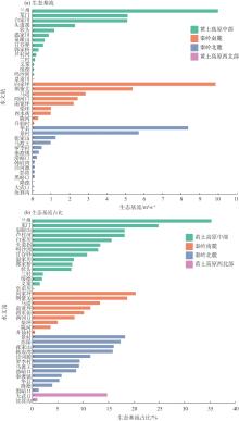
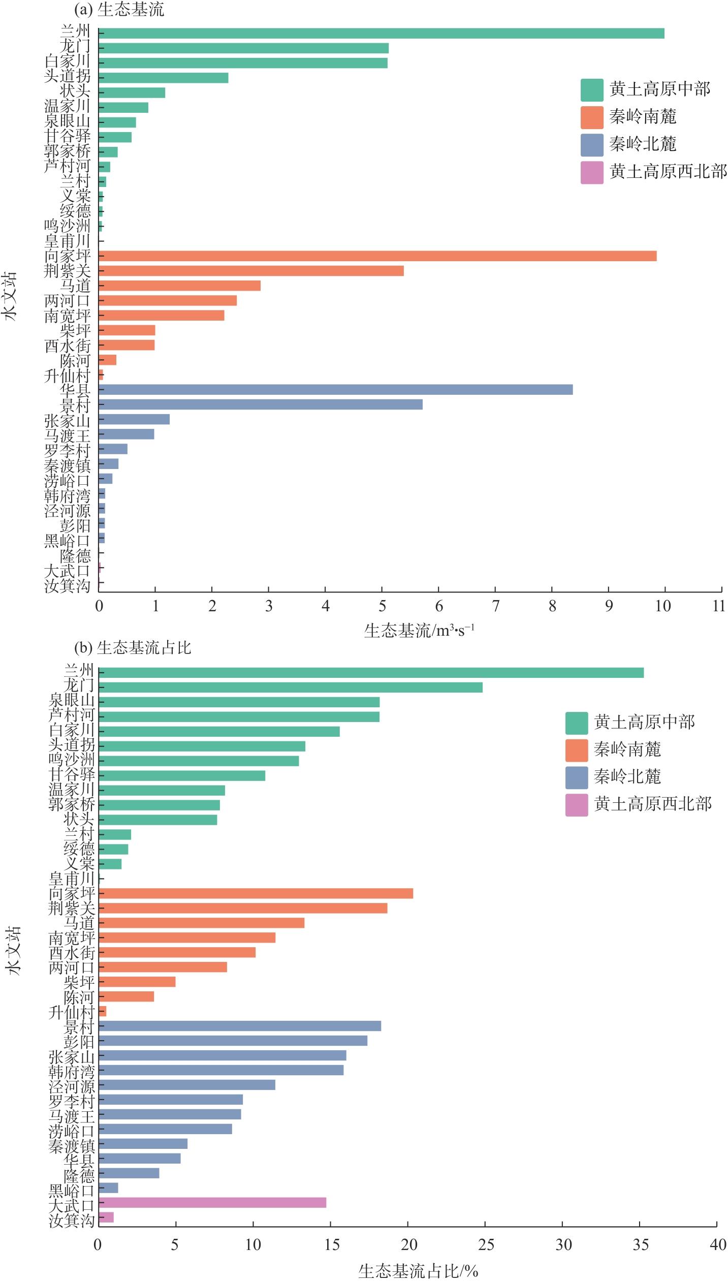
刘欢, 胡鹏, 王建华, 等. 中国河流分区分类生态基流占比阈值确定[J]. 南水北调与水利科技, 2022, 20(4): 748-756.
|
|
[Liu Huan, Hu Peng, Wang Jianhua, et al. Determination of the proportion thresholds of ecological base flow in rivers with different scales in different watersheds of China[J]. South-to-North Water Transfers and Water Science & Technology, 2022, 20(4): 748-756. ]
|
| [24] |
曹原, 李娅芸. 陕西省渭河控制断面生态流量目标及调度措施[J]. 地下水, 2024, 46(2): 240-242.
|
|
[Cao Yuan, Li Yayun. Ecological flow objectives and management for Wei River control points in Shaanxi Province[J]. Ground Water, 2024, 46(2): 240-242. ]
|
| [25] |
王小帆, 苗磊, 翟城武. 基于无定河生态流量保障的水资源调度研究[J]. 陕西水利, 2024(4): 32-35.
|
|
[Wang Xiaofan, Miao Lei, Zhai Chengwu. Research on water resources regulation based on the guarantee of ecological flow in Wuding River Basin[J]. Shaanxi Water Resources, 2024(4): 32-35. ]
|
| [26] |
Liu H, Hu P, Wang J H, et al. A flexible framework for regionalization of base flow for river habit maintenance and its thresholds[J]. Science of the Total Environment, 2023, 876: 162748, doi: 10.1016/j.scitotenv.2023.162748.
|
| [27] |
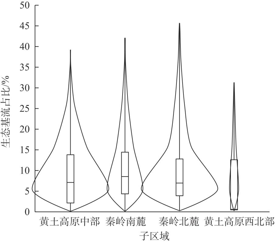
李婷, 吕一河, 任艳姣, 等. 黄土高原植被恢复成效及影响因素[J]. 生态学报, 2020, 40(23): 8593-8605.
|
|
[Li Ting, Lü Yihe, Ren Yanjiao, et al. Gauging the effectiveness of vegetation restoration and the influence factors in the Loess Plateau[J]. Acta Ecologica Sinica, 2020, 40(23): 8593-8605. ]
|
| [28] |
Price K. Effects of watershed topography, soils, land use, and climate on baseflow hydrology in humid regions: A review[J]. Progress in Physical Geography, 2011, 35(4): 465-492.
|
| [29] |
Lei H M, Yang D W, Huang M Y. Impacts of climate change and vegetation dynamics on runoff in the mountainous region of the Haihe River Basin in the past five decades[J]. Journal of Hydrology, 2014, 511: 786-799.
|
| [30] |
冯憬, 卫伟, 冯青郁. 黄土丘陵区SCS-CN模型径流曲线数的计算与校正[J]. 生态学报, 2021, 41(10): 4170-4181.
|
|
[Feng Jing, Wei Wei, Feng Qingyu. The runoff curve number of SCS-CN method in loess hilly region[J]. Acta Ecologica Sinica, 2021, 41(10): 4170-4181. ]
|
| [31] |
宋林辉, 黄强, 闫迪, 等. 水力梯度对黏土渗透性影响的试验研究[J]. 岩土工程学报, 2018, 40(9): 1635-1641.
|
|
[Song Linhui, Huang Qiang, Yan Di, et al. Experimental study on effect of hydraulic gradient on permeability of clay[J]. Chinese Journal of Geotechnical Engineering, 2018, 40(9): 1635-1641. ]
|
| [32] |
傅伯杰, 刘彦随, 曹智, 等. 黄土高原生态保护和高质量发展现状、问题与建议[J]. 中国科学院院刊, 2023, 38(8): 1110-1117.
|
|
[Fu Bojie, Liu Yansui, Cao Zhi, et al. Current conditions, issues, and suggestions for ecological protection and high-quality development in Loess Plateau[J]. Bulletin of Chinese Academy of Sciences, 2023, 38(8): 1110-1117. ]
|
| [33] |
Wu Y R, Zhang H B, Lan T, et al. Attribution of runoff variation to climate and human-driven changes in the transition zone between the Qinling Mountains and the Loess Plateau under vegetation greening[J]. Hydrology Research, 2022, 53(5): 733-753.
|
| [34] |
Xiao T, Li P, Fei W B, et al. Effects of vegetation roots on the structure and hydraulic properties of soils: A perspective review[J]. Science of the Total Environment, 2024, 906: 167524, doi: 10.1016/j.scitotenv.2023.167524.
|
 ), 于坤霞1(