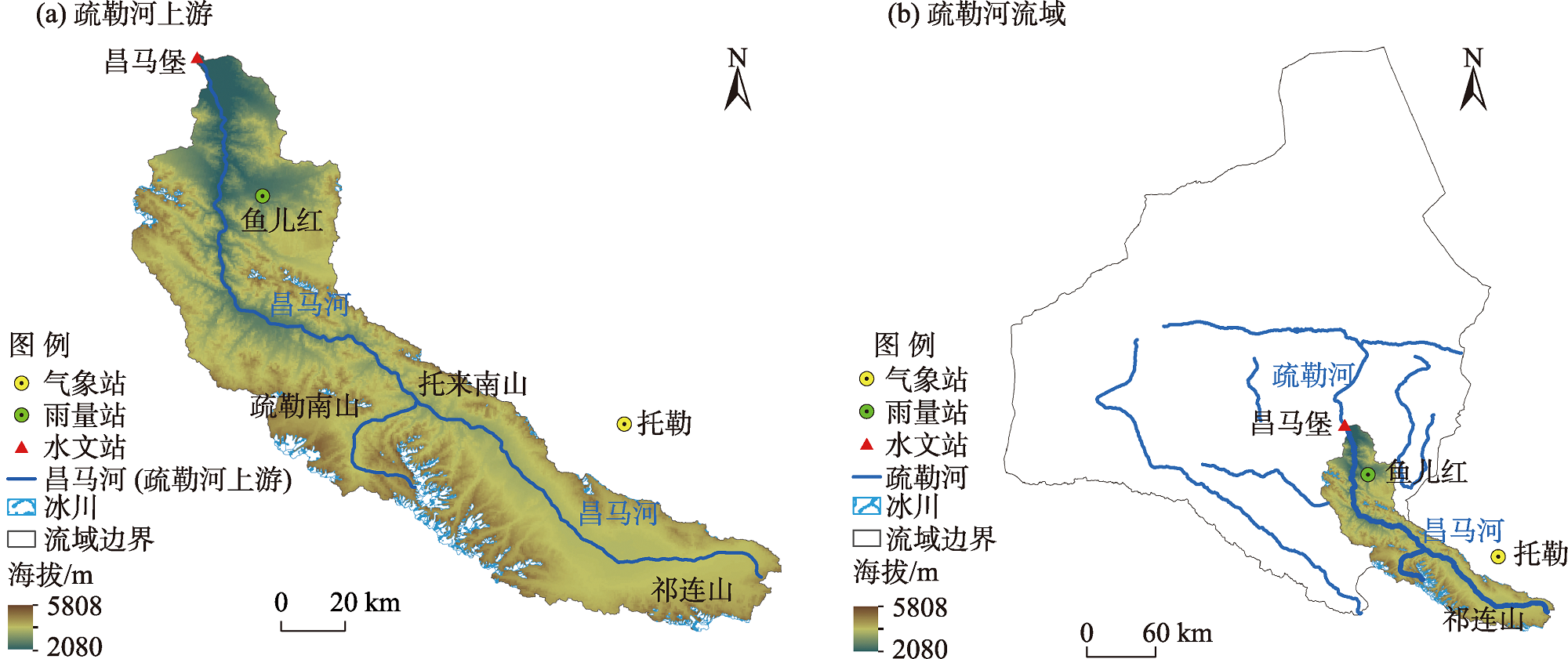
| [1] |
Desai B, Maskrey A, Peduzzi P, et al. Making development sustainable:The future of disaster risk management. Global Assessment Report on Disaster Risk Reduction[R]. Genève, Suisse: United Nations Office for Disaster Risk Reduction (UNISDR), 2015.
|
| [2] |
Alfieri L, Bisselink B, Dottori F, et al. Global projections of river flood risk in a warmer world[J]. Earths Future, 2017, 5(2): 171-182.
doi: 10.1002/eft2.2017.5.issue-2
|
| [3] |
Cornwall W. Europe’s deadly floods leave scientists stunned[J]. Science, 2021, 373(6553): 372-373.
doi: 10.1126/science.373.6553.372
pmid: 34437095
|
| [4] |
Arnell Nigel W, Gosling Simon N. The impacts of climate change on river flood risk at the global scale[J]. Climate Change, 2014, 134: 387-401.
doi: 10.1007/s10584-014-1084-5
|
| [5] |
Bloeschl G, Hall J, Viglione A, et al. Changing climate both increases and decreases European river floods[J]. Nature, 2019, 573: 108-111.
doi: 10.1038/s41586-019-1495-6
|
| [6] |
Bloschl G, Hall J, Parajka J, et al. Changing climate shifts timing of European floods[J]. Science, 2017, 357(6351): 588-590.
doi: 10.1126/science.aan2506
pmid: 28798129
|
| [7] |
Kundzewicz Z W, Su B, Wang Y, et al. Flood risk in a range of spatial perspectives-from global to local scales[J]. Natural Hazards and Earth System Sciences, 2019, 19(7): 1319-1328.
doi: 10.5194/nhess-19-1319-2019
|
| [8] |
Hodgkins G A, Whitfield P H, Burn D H, et al. Climate-driven variability in the occurrence of major floods across North America and Europe[J]. Journal of Hydrology, 2017, 552: 704-717.
doi: 10.1016/j.jhydrol.2017.07.027
|
| [9] |
Mediero L, Santillan D, Garrote L, et al. Detection and attribution of trends in magnitude, frequency and timing of floods in Spain[J]. Journal of Hydrology, 2014, 517: 1072-1088.
doi: 10.1016/j.jhydrol.2014.06.040
|
| [10] |
Zadeh S M, Burn D H, O’Brien N. Detection of trends in flood magnitude and frequency in Canada[J]. Journal of Hydrology-Regional Studies, 2020, 28: 13, doi: 10.1016/j.ejrh.2020.100673.
doi: 10.1016/j.ejrh.2020.100673
|
| [11] |
Zhang Q, Gu X H, Singh V P, et al. Magnitude, frequency and timing of floods in the Tarim River Basin, China: Changes, causes and implications[J]. Global and Planetary Change, 2016, 139: 44-55.
doi: 10.1016/j.gloplacha.2015.10.005
|
| [12] |
蒋军新, 蔡明, 徐永军, 等. 新疆阿克苏河流域洪水演变趋势研究[J]. 冰川冻土, 2021, 43(4): 1200-1209.
doi: 10.7522/j.issn.1000-0240.2021.0128
|
|
[Jiang Junxin, Cai Ming, Xu Yongjun, et al. Evolution trend of flood in the Aksu River Basin, Xinjiang[J]. Journal of Glaciology and Geocryology, 2021, 43(4): 1200-1209.]
doi: 10.7522/j.issn.1000-0240.2021.0128
|
| [13] |
毛炜峄, 樊静, 沈永平, 等. 近50 a来新疆区域与天山典型流域极端洪水变化特征及其对气候变化的响[J]. 冰川冻土, 2012, 34(5): 1037-1046.
|
|
[Mao Weiyi, Fan Jing, Shen Yongping, et al. Variations of extreme flood of the rivers in Xinjiang region and some typical watersheds from Tianshan Mountains and their response to climate change in recent 50 years[J]. Journal of Glaciology and Geocryology, 2012, 34(5): 1037-1046.]
|
| [14] |
Wang X L, Chen R S, Li H Y, et al. Detection and attribution of trends in flood frequency under climate change in the Qilian Mountains, northwest China[J]. Journal of Hydrology-Regional Studies, 2022, 42: 101153, doi: 10.1016/j.ejrh.2022.101153.
doi: 10.1016/j.ejrh.2022.101153
|
| [15] |
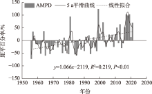
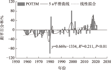
王学良, 陈仁升, 刘俊峰, 等. 1956—2021年疏勒河流域主要河流出山径流变化及成因分析[J]. 干旱区研究, 2022, 39(6): 1782-1792.
|
|
[Wang Xueliang, Chen Rensheng, Liu Junfeng, et al. Changes in runoff from major rivers and analysis of its causes in Shule River Basin from 1956—2021[J]. Arid Zone Research, 2022, 39(6): 1782-1792.]
|
| [16] |
Wang H J, Chen Y N, Li W H, et al. Runoff responses to climate change in arid region of northwestern China during 1960—2010[J]. Chinese Geographical Science, 2013, 23(3): 286-300.
doi: 10.1007/s11769-013-0605-x
|
| [17] |
Chen R S, Han C T, Liu J F, et al. Maximum precipitation altitude on the northern flank of the Qilian Mountains, northwest China[J]. Hydrology Research, 2018, 49(5): 1696-1710.
doi: 10.2166/nh.2018.121
|
| [18] |
Liu G H, Chen R S, Li K L. Glacial change and its hydrological response in three inland river basins in the Qilian Mountains, western China[J]. Water, 2021, 13(16): 2213, doi: 10.3390/w13162213.
doi: 10.3390/w13162213
|
| [19] |
盛煜, 李静, 吴吉春, 等. 基于GIS的疏勒河流域上游多年冻土分布特征[J]. 中国矿业大学学报, 2010, 39(1): 32-39.
|
|
[Sheng Yu, Li Jing, Wu Jichun, et al. Distribution patterns of permafrost in the upper area of Shule River with the application of GIS technique[J]. Journal of China University of Mining & Technology, 2010, 39(1): 32-39.]
|
| [20] |
Sen P K. Estimates of the regression coefficient based on Kendall’s Tau[J]. Journal of the American Statistical Association, 1968, 63(324): 1379-1389.
doi: 10.1080/01621459.1968.10480934
|
| [21] |
Mann H B. Nonparametric test against trend[J]. Econometrica: Journal of the Econometric Society, 1945, 13(3): 245-259.
doi: 10.2307/1907187
|
| [22] |
Kendall M G. Rank correlation methods[J]. British Journal of Psychology, 1975, 25(1): 86-91.
|
| [23] |
郭生练, 刘章君, 熊立华. 设计洪水计算方法研究进展与评价[J]. 水利学报, 2016, 47(3): 302-314.
|
|
[Guo Shenglian, Liu Zhangjun, Xiong Lihua. Advances and assessment on design flood estimation methods[J]. Journal of Hydraulic Engineering, 2016, 47(3): 302-314.]
|
| [24] |
Lang M, Ouarda T, Bobee B. Towards operational guidelines for over-threshold modeling[J]. Journal of Hydrology, 1999, 225(3-4): 103-117.
doi: 10.1016/S0022-1694(99)00167-5
|
| [25] |
陈庭兴, 吕海深, 朱永华. 基于GEV分布的西营河流域洪水特性分析[J]. 干旱区研究, 2021, 38(6): 1563-1569.
|
|
[Chen Tingxing, Lü Haishen, Zhu Yonghua. Analysis of flood characteristics in Xiying River Basin based on GEV distribution[J]. Arid Zone Research, 2021, 38(6): 1563-1569.]
|
| [26] |
施雅风, 沈永平, 李栋梁, 等. 中国西北气候由暖干向暖湿转型的特征和趋势探讨[J]. 第四纪研究, 2003, 23(2): 152-164.
|
|
[Shi Yafeng, Shen Yongping, Li Dongliang, et al. Discussion on the present climate change from warm-dry to warm-wet in northwest China[J]. Quaternary Sciences, 2003, 23(2): 152-164.]
|
| [27] |
蓝永超, 胡兴林, 丁宏伟, 等. 气候变暖背景下祁连山西部山区水循环要素的变化——以疏勒河干流上游山区为例[J]. 山地学报, 2012, 30(6): 675-680.
|
|
[Lan Yongchao, Hu Xinglin, Ding Hongwei, et al. Variation of water cycle factors in the western Qilian Mountain area under climate warming: Taking the mountain watershed of the main stream of Shule River Basin for example[J]. Journal of Mountain Science, 2012, 30(6): 675-680.]
|
| [28] |
徐浩杰, 杨太保, 张晓晓. 近50年来疏勒河上游气候变化及其对地表径流的影响[J]. 西安理工大学学报, 2014, 34(4): 40-45, 52.
|
|
[Xu Haojie, Yang Taibao, Zhang Xiaoxiao. Climate change in upstream area of Shule River and its effects on runoff-yield in last 50 years[J]. Bulletin of Soil and Water Conservation, 2014, 34(4): 40-45, 52.]
|
| [29] |
Chen Y N, Li Z, Fan Y T, et al. Progress and prospects of climate change impacts on hydrology in the arid region of northwest China[J]. Environmental Research, 2015, 139: 11-19.
doi: 10.1016/j.envres.2014.12.029
pmid: 25682220
|
| [30] |
陈亚宁, 王怀军, 王志成, 等. 西北干旱区极端气候水文事件特征分析[J]. 干旱区地理, 2017, 40(1): 1-9.
|
|
[Chen Yaning, Wang Huaijun, Wang Zhicheng, et al. Characteristics of extreme climatic/hydrological events in the arid region of northwestern China[J]. Arid Land Geography, 2017, 40(1): 1-9.]
|
| [31] |
陈仁升, 张世强, 阳勇, 等. 冰冻圈变化对中国西部寒区径流的影响[M]. 北京: 科学出版社, 2019: 45-73.
|
|
[Chen Rensheng, Zhang Shiqiang, Yang Yong, et al. The impacts of cryospheric changes on cold region runoff in western China[M]. Beijing: Science Press, 2019: 45-73.]
|
| [32] |
晋子振, 秦翔, 赵求东, 等. 祁连山西段老虎沟流域消融季径流变化特征研究[J]. 干旱区地理, 2023, 46(2): 178-190.
|
|
[Jin Zizhen, Qin Xiang, Zhao Qiudong, et al. Characteristics of runoff variation during ablation season in Laohugou watershed of western Qilian Mountains[J]. Arid Land Geography, 2023, 46(2): 178-190.]
|
| [33] |
孙美平, 刘时银, 姚晓军, 等. 近50年来祁连山冰川变化——基于中国第一、二次冰川编目数据[J]. 地理学报, 2015, 70(9): 1402-1414.
doi: 10.11821/dlxb201509004
|
|
[Sun Meiping, Liu Shiyin, Yao Xiaojun, et al. Glacier changes in the Qilian Mountains in the past half century: Based on the revised First and Second Chinese Glacier Inventory[J]. Acta Geographica Sinica, 2015, 70(9): 1402-1414.]
doi: 10.11821/dlxb201509004
|
| [34] |
刘时银, 姚晓军, 郭万钦, 等. 基于第二次冰川编目的中国冰川现状[J]. 地理学报, 2015, 70(1): 3-16.
doi: 10.11821/dlxb201501001
|
|
[Liu Shiyin, Yao Xiaojun, Guo Wanqin, et al. The contemporary glaciers in China based on the Second Chinese Glacier Inventory[J]. Acta Geographica Sinica, 2015, 70(1): 3-16.]
doi: 10.11821/dlxb201501001
|
| [35] |
丁永建, 张世强, 吴锦奎, 等. 中国冰冻圈水文过程变化研究新进展[J]. 水科学进展, 2020, 31(5): 690-702.
|
|
[Ding Yongjian, Zhang Shiqiang, Wu Jinkui, et al. Recent progress on studies on cryospheric hydrological processes changes in China[J]. Advances in Water Science, 2020, 31(5): 690-702.]
|
 ),陈仁升1(