干旱区地理 ›› 2026, Vol. 49 ›› Issue (11): 2346-2360.doi: 10.12118/j.issn.1000-6060.2026.255 cstr: 32274.14.ALG2026255
杜玉欣1( ), 孙艺香2, 朱小青3, 刘咏梅1,4(), 严俊娟1, 陈国魂1
收稿日期:2026-04-13
修回日期:2026-07-31
出版日期:2026-11-25
发布日期:2026-11-13
通讯作者:
刘咏梅(1970-),女,博士,教授,主要从事土地资源管理与遥感、GIS应用研究. E-mail: liuym@nwu.edu.cn作者简介:杜玉欣(2002-),女,硕士研究生,主要从事土地资源管理研究. E-mail: 202421691@stumail.nwu.edu.cn论文构思:杜玉欣、刘咏梅;数据管理:杜玉欣;规范分析:杜玉欣;获取资助:刘咏梅;调查研究:杜玉欣;方法设计:杜玉欣、孙艺香、朱小青;项目管理:刘咏梅;提供资源:刘咏梅;软件编程:杜玉欣;监督指导:孙艺香、朱小青、刘咏梅;验证复核:杜玉欣;可视化:杜玉欣、严俊娟、陈国魂;初稿撰写:杜玉欣;修订编辑:刘咏梅。
基金资助:
DU Yuxin1(), SUN Yixiang2, ZHU Xiaoqing3, LIU Yongmei1,4(), YAN Junjuan1, CHEN Guohun1
Received:2026-04-13
Revised:2026-07-31
Published:2026-11-25
Online:2026-11-13
摘要:
土地资源利用的集约化和高效率对黄河流域生态保护和高质量发展具有重要意义。采用熵权法、K-Medoids聚类法、耦合协调度模型、地理探测器和时空地理加权回归(GTWR)模型等方法,分析了2014—2023年黄河流域城市土地集约利用度及系统协调度的时空演化规律,并探讨了其驱动机制的空间分异特征。结果表明:(1)在经济高速发展的10 a间,黄河流域城市土地集约利用度与系统协调度稳步上升,呈现从西向东梯度递增并向区域中心城市聚集的空间分布格局,各城市土地集约利用度与系统协调度之间的协同性持续优化。(2)黄河流域城市土地集约利用度具有多元驱动复杂性,综合解释力从大到小依次为:经济发展>社会文明>自然条件,主要驱动因子为经济水平、对外开放、科技创新、政府财政、产业结构和地形起伏。其中,经济水平和其他因子的协同作用对黄河流域城市土地集约利用度具有最显著的增强效应。(3)GTWR模型结果显示,各驱动因子作用具有明显的区域差异特征,经济发展、科技创新/产业结构分别对“低集约-低协调”“高集约-高协调”型城市具有显著提升效应,而对外开放的影响则具有空间复杂性。研究结果可为黄河流域土地集约利用、生态文明和经济建设的均衡高质量发展提供参考和依据。
杜玉欣, 孙艺香, 朱小青, 刘咏梅, 严俊娟, 陈国魂. 黄河流域城市土地集约利用度及驱动力的时空分异特征[J]. 干旱区地理, 2026, 49(11): 2346-2360.
DU Yuxin, SUN Yixiang, ZHU Xiaoqing, LIU Yongmei, YAN Junjuan, CHEN Guohun. Spatiotemporal heterogeneity of the land intensive use degree and its driving factors for cities in the Yellow River Basin[J]. Arid Land Geography, 2026, 49(11): 2346-2360.
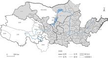
图1
研究区示意图 注:基于自然资源部标准地图服务网站审图号为GS(2024)0650号的标准地图制作,底图边界无修改。下同。"
表1
黄河流域城市土地集约利用度评价指标及权重"
| 子系统 | 指标层 | 指标意义 | 单位 | 性质 | 权重 |
|---|---|---|---|---|---|
| 土地投入水平 | 建设用地地均固定资产投资 | 固定资产投资额/建设用地面积 | 104元·km-2 | + | 0.0624 |
| 地均财政投入 | 一般公共预算支出/土地总面积 | 104元·km-2 | + | 0.0786 | |
| 地均公用设施建设投入 | 市公用设施建设投入/土地总面积 | 104元·km-2 | + | 0.2780 | |
| 土地利用强度 | 城乡建设用地人口密度 | 城市人口/建设用地面积 | 人·km-2 | + | 0.0715 |
| 建成区比例 | 建成区面积/土地总面积 | % | + | 0.1401 | |
| 建设用地地均地区生产总值 | 生产总值/建设用地面积 | 104元·km-2 | + | 0.0375 | |
| 土地利用效益 | 建设用地地均二三产业增加值 | 二三产业增加值/建设用地面积 | 104元·km-2 | + | 0.0345 |
| 地均财政收入 | 一般公共预算收入/土地总面积 | 104元·km-2 | + | 0.1441 | |
| 建成区绿化覆盖率 | 建成区绿化覆盖面积/建成区面积 | % | + | 0.0041 | |
| 城镇居民人均可支配收入 | 城镇居民人均可支配收入 | 元·人-1 | + | 0.0083 | |
| 地均社会消费品零售总额 | 社会消费品零售总额/土地总面积 | 104元·km-2 | + | 0.1348 | |
| 土地反馈机制 | 单位人口增长消耗新增建设用地量 | 建设用地净增量/常住人口净增量 | m2·人-1 | - | 0.0048 |
| 经济用地弹性 | 建设用地面积增长率/地区生产总值增长率 | + | 0.0012 |
表2
黄河流域城市土地集约利用度影响因子指标体系"
| 影响因素 | 指标 | 指标说明 | 单位 |
|---|---|---|---|
| 经济发展 | 经济水平 | 地均GDP | 104元·km-2 |
| 对外开放 | 进出口总额占GDP比重 | % | |
| 产业结构 | 二三产业增加值占GDP比重 | % | |
| 社会文明 | 科技创新 | 教育和科技支出占GDP比重 | % |
| 政府财政 | 政府支出占收入比重 | % | |
| 城市环境 | 人均公园绿地面积 | m2·人-1 | |
| 自然条件 | 人口因素 | 人口密度 | 人·km-2 |
| 地形起伏 | 地形坡度 | (°) | |
| 河网密度 | 河网密度 | km·km-2 |
表3
交互作用类型"
| 判据 | 交互作用 |
|---|---|
| 非线性减弱 | |
| 单因子非线性减弱 | |
| 双因子增强 | |
| 独立 | |
| 非线性增强 |
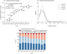
图2
2014—2023年黄河流域城市土地集约利用度年际变化"
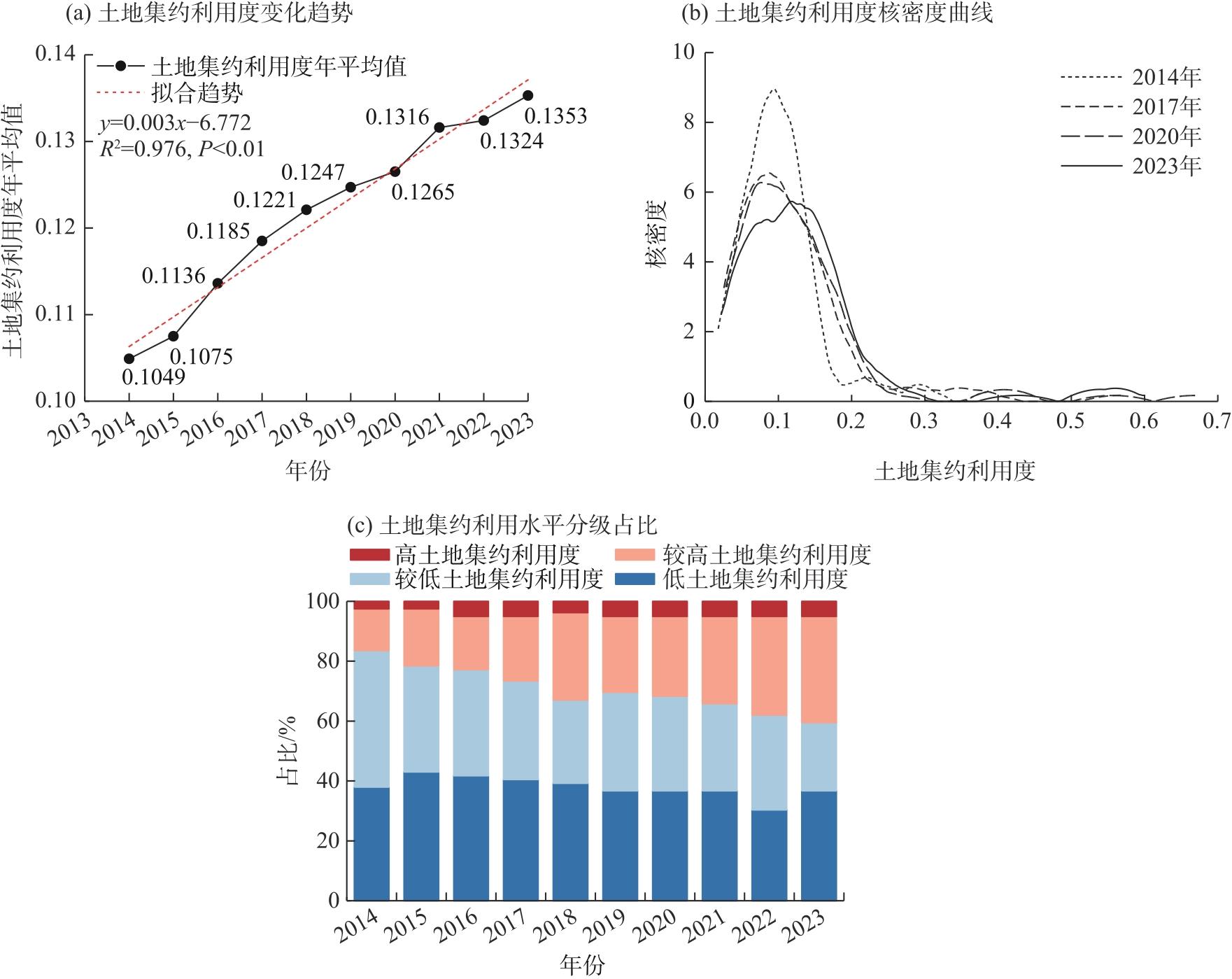
图3
2014—2023年黄河流域城市土地集约利用度空间分布"
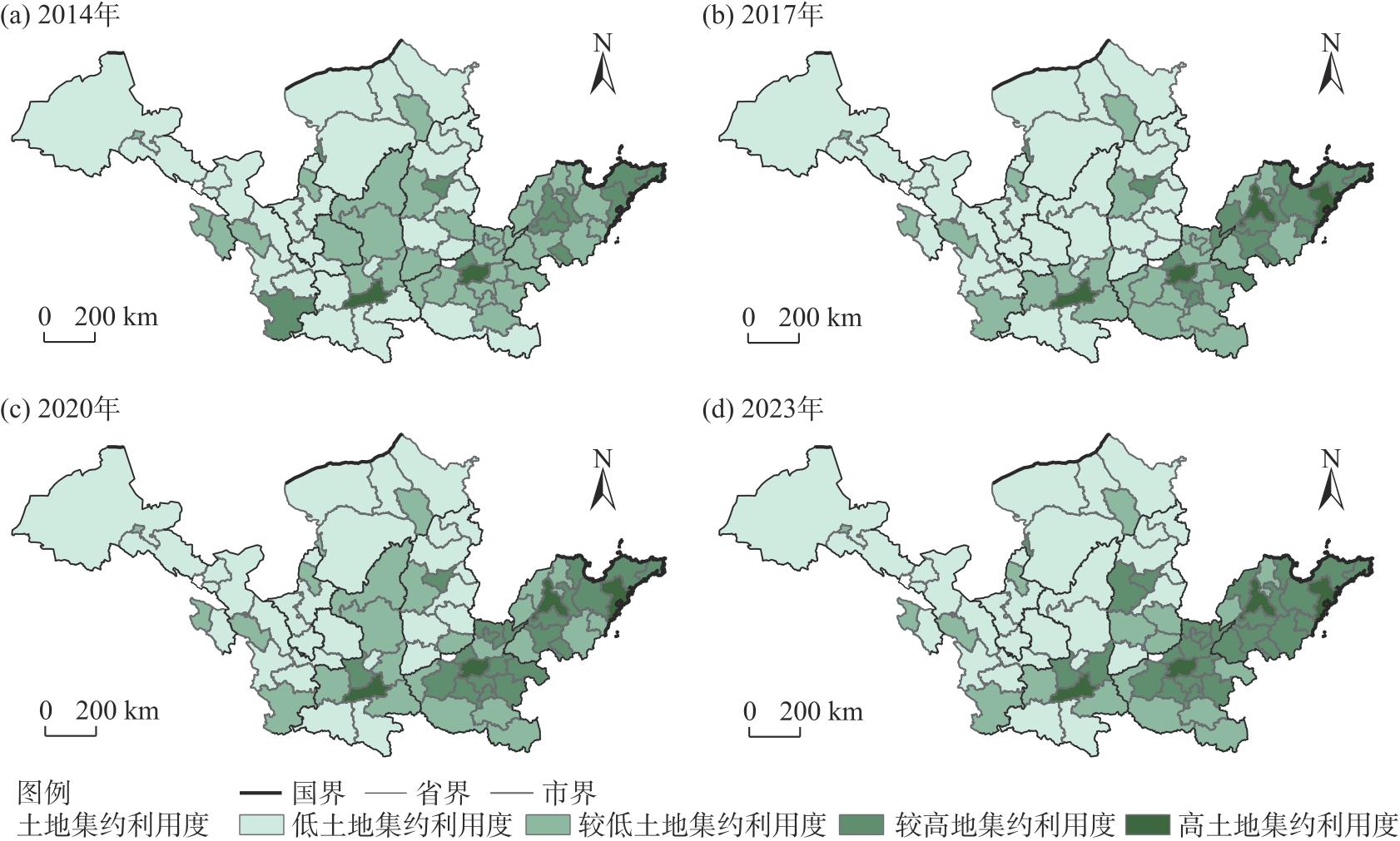
图4
2014—2023年黄河流域城市土地集约利用内部协调度空间分布"
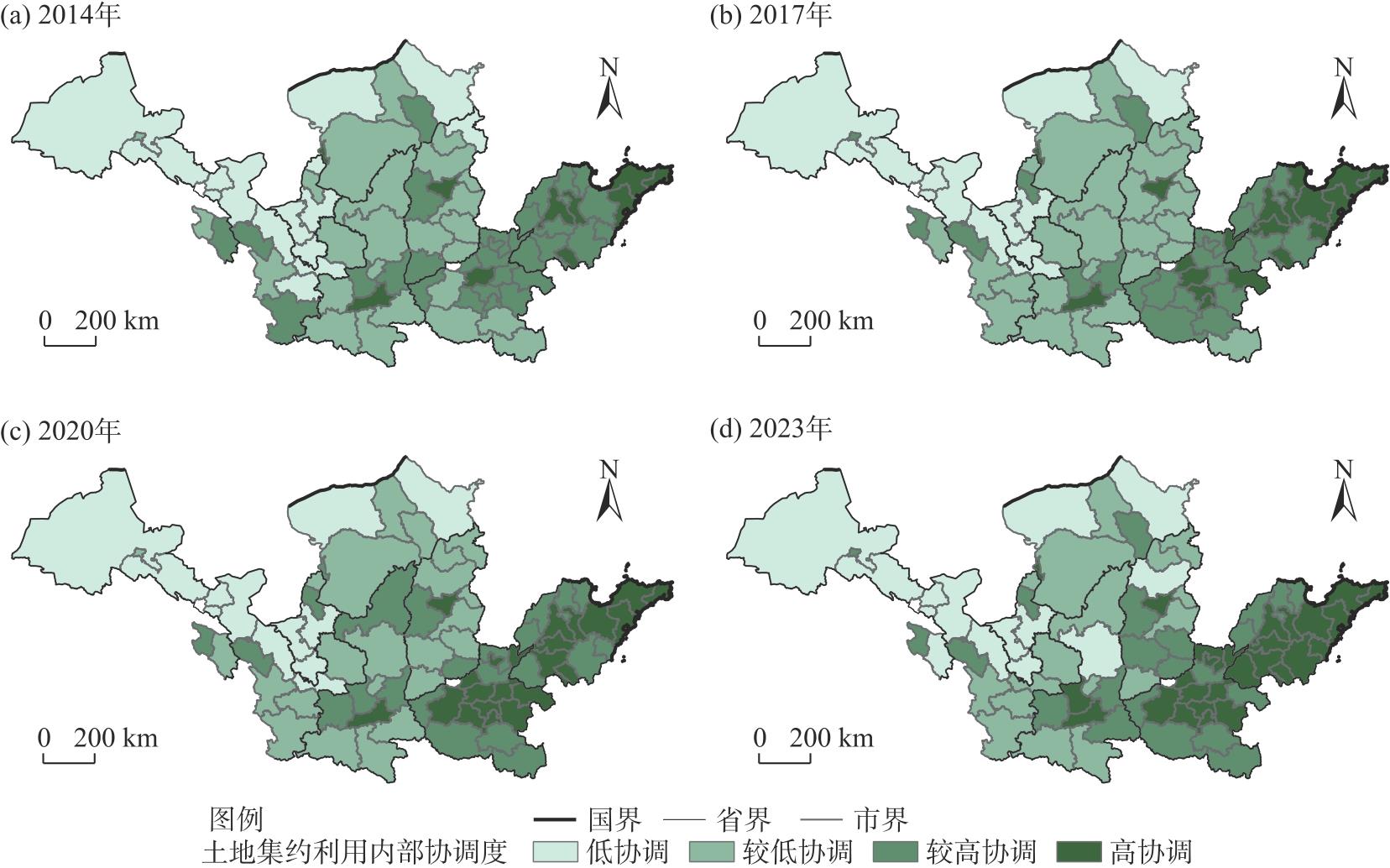
图5
2014—2023年黄河流域城市土地集约利用度与内部协调度之间的演变关系"
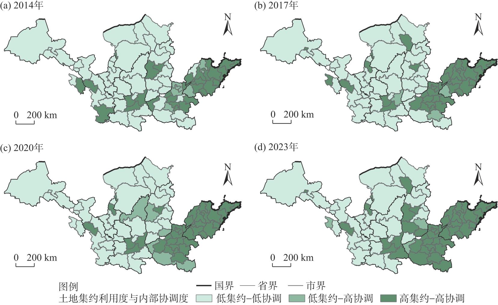
表4
单因子探测结果"
| 影响因子 | 指标 | 2014年 | 2017年 | 2020年 | 2023年 | |||||||
|---|---|---|---|---|---|---|---|---|---|---|---|---|
| q值 | P值 | q值 | P值 | q值 | P值 | q值 | P值 | |||||
| 经济发展 | 经济水平 | 0.6962* | 0.0000 | 0.8837* | 0.0000 | 0.9324* | 0.0000 | 0.9286* | 0.0000 | |||
| 对外开放 | 0.3952* | 0.0189 | 0.2445* | 0.0379 | 0.2838* | 0.0339 | 0.2533 | 0.0650 | ||||
| 产业结构 | 0.1955* | 0.0000 | 0.1608* | 0.0061 | 0.1565* | 0.0175 | 0.2154* | 0.0028 | ||||
| 社会文明 | 科技创新 | 0.2327* | 0.0021 | 0.2620* | 0.0000 | 0.1870* | 0.0050 | 0.1559* | 0.0156 | |||
| 政府财政 | 0.2522* | 0.0000 | 0.2207* | 0.0000 | 0.1670* | 0.0105 | 0.1711* | 0.0082 | ||||
| 城市环境 | 0.0443 | 0.5511 | 0.0449 | 0.5169 | 0.0525 | 0.4182 | 0.0635 | 0.3465 | ||||
| 自然条件 | 人口因素 | 0.3114 | 0.6592 | 0.0146 | 0.9209 | 0.0592 | 0.6001 | 0.0600 | 0.7043 | |||
| 地形起伏 | 0.2169* | 0.0036 | 0.2693* | 0.0000 | 0.2158* | 0.0000 | 0.2324* | 0.0000 | ||||
| 河网密度 | 0.0085 | 0.9900 | 0.0221 | 0.9356 | 0.0092 | 0.9788 | 0.0131 | 0.9647 | ||||
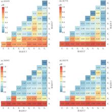
图6
交互探测器结果 注:X1、X2、X3、X4、X5、X6、X7、X8、X9分别为经济水平、对外开放、产业结构、科技创新、政府财政、城市环境、人口因素、地形起伏、河网密度;*表示非线性增强交互作用;q为影响因子对土地集约利用度的影响力。"
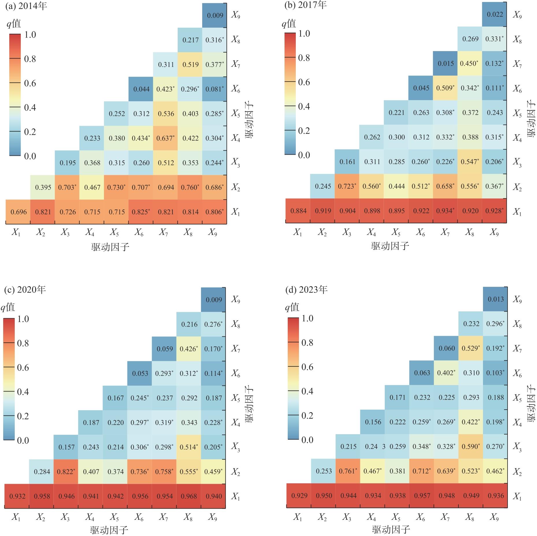
图7
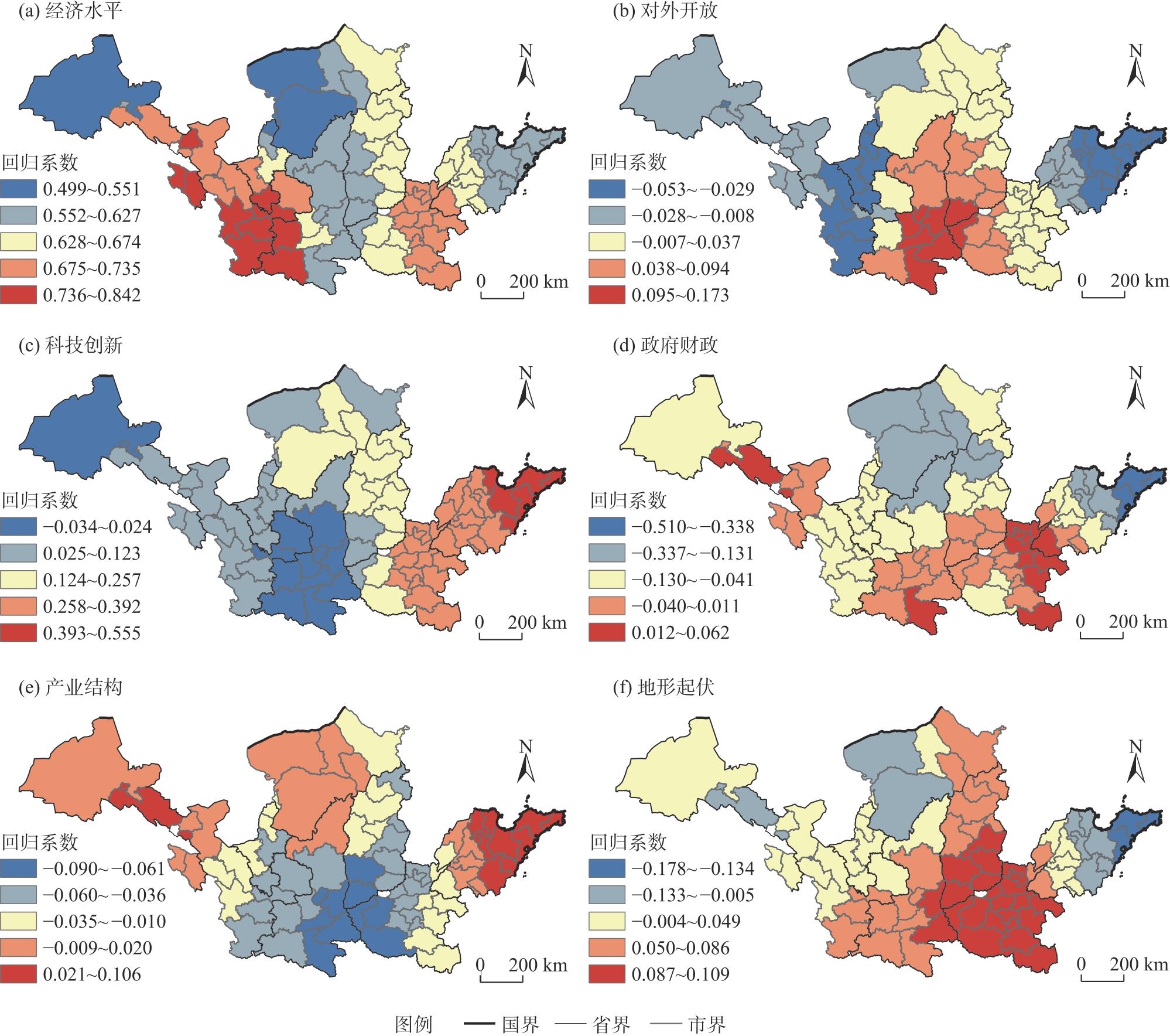
黄河流域城市土地集约利用度主要驱动因子的回归系数"
| [1] | 蒋正云, 周杰文. 长江经济带土地集约利用与绿色经济效率时空耦合特征及驱动因素[J]. 长江流域资源与环境, 2024, 33(4): 742-757. |
| [Jiang Zhengyun, Zhou Jiewen. Spatial-temporal coupling characteristics and driving factors of intensive land use and green economic efficiency in the Yangtze River Economic Belt[J]. Resources and Environment in the Yangtze Basin, 2024, 33(4): 742-757.] | |
| [2] |
邓祥征, 杨开忠, 单菁菁, 等. 黄河流域城市群与产业转型发展[J]. 自然资源学报, 2021, 36(2): 273-289.
doi: 10.31497/zrzyxb.20210201 |
|
[Deng Xiangzheng, Yang Kaizhong, Shan Jingjing, et al. Urban agglomeration and industrial transformation and development in the Yellow River Basin[J]. Journal of Natural Resources, 2021, 36(2): 273-289.]
doi: 10.31497/zrzyxb.20210201 |
|
| [3] | 何平, 倪苹. 中国城镇化质量研究[J]. 统计研究, 2013, 30(6): 11-18. |
| [He Ping, Ni Ping. Study on the quality of China’s urbanization[J]. Statistical Research, 2013, 30(6): 11-18.] | |
| [4] |
郭付友, 佟连军, 仇方道, 等. 黄河流域生态经济走廊绿色发展时空分异特征与影响因素识别[J]. 地理学报, 2021, 76(3): 726-739.
doi: 10.11821/dlxb202103016 |
|
[Guo Fuyou, Tong Lianjun, Chou Fangdao, et al. Spatio-temporal differentiation characteristics and influencing factors of green development in the eco-economic corridor of the Yellow River Basin[J]. Acta Geographica Sinica, 2021, 76(3): 726-739.]
doi: 10.11821/dlxb202103016 |
|
| [5] | 王群, 王万茂, 金雯, 等. 中国城市土地集约利用研究中的新观点和新方法: 综述与展望[J]. 中国人口·资源与环境, 2017, 27(增刊1): 95-100. |
| [Wang Qun, Wang Wanmao, Jin Wen, et al. New perspectives and new methods on the research of intensive urban land use in China: Literature review and prospect[J]. China Population, Resources and Environment, 2017, 27(Suppl. 1): 95-100.] | |
| [6] |
尹旭, 李裕瑞, 袁涛, 等. 镇域经济发展与土地集约利用水平综合测度及其关联特征分析——以江苏省109个抽样乡镇为例[J]. 自然资源学报, 2020, 35(3): 614-625.
doi: 10.31497/zrzyxb.20200309 |
|
[Yin Xu, Li Yurui, Yuan Tao, et al. Quantitative measurement of economic development and land use intensity and their correlation characteristics in 109 sampled towns of Jiangsu Province[J]. Journal of Natural Resources, 2020, 35(3): 614-625.]
doi: 10.31497/zrzyxb.20200309 |
|
| [7] |
赵丹丹, 胡业翠. 土地集约利用与城市化相互作用的定量研究——以中国三大城市群为例[J]. 地理研究, 2016, 35(11): 2105-2115.
doi: 10.11821/dlyj201611008 |
| [Zhao Dandan, Hu Yecui. Quantitative study of the interaction between intensive land use and urbanization in three urban agglomerations of China[J]. Geographical Research, 2016, 35(11): 2105-2115.] | |
| [8] | 白玉娟, 洪增林, 薛旭平, 等. 关中平原城市群土地集约利用与生态文明建设耦合性研究[J]. 水土保持研究, 2021, 28(3): 272-280. |
| [Bai Yujuan, Hong Zenglin, Xue Xuping, et al. Research on coupling of intensive land use and ecological civilization construction of urban agglomeration in Guanzhong Plain[J]. Research of Soil and Water Conservation, 2021, 28(3): 272-280.] | |
| [9] | 董捷, 陈星, 张安录. 基于“三生”功能的长江中游城市群土地集约利用空间差异研究[J]. 华中农业大学学报(社会科学版), 2017(6): 110-117, 152. |
| [Dong Jie, Chen Xing, Zhang Anlu. Research on the spatial difference in land intensive use based on the function of production-ecology-living spaces in urban agglomeration in the middle reaches of the Yangtze River[J]. Journal of Huazhong Agricultural University (Social Sciences Edition), 2017(6): 110-117, 152.] | |
| [10] | 王向东, 刘小茜, 裴韬, 等. 基于技术效率测算的京津冀城市土地集约利用潜力评价[J]. 地理学报, 2019, 74(9): 1853-1865. |
|
[Wang Xiangdong, Liu Xiaoqian, Pei Tao, et al. Potential evaluation of urban land intensive use in Beijing-Tianjin-Hebei region based on measurement of technical efficiency[J]. Acta Geographica Sinica, 2019, 74(9): 1853-1865.]
doi: 10.11821/dlxb201909011 |
|
| [11] | 鲁学孟, 刘学录, 张晶, 等. 甘肃省庆阳市土地集约利用与土地利用结构的耦合协调关系[J]. 水土保持通报, 2019, 39(6): 240-245. |
| [Lu Xuemeng, Liu Xuelu, Zhang Jing, et al. Coupling coordination relationship between land intensive use and land use structure in Qingyang City of Gansu Province[J]. Bulletin of Soil and Water Conservation, 2019, 39(6): 240-245.] | |
| [12] |
范辉, 刘卫东, 吴泽斌. 城市土地集约利用内部协调性的时空演变——以武汉市中心城区为例[J]. 地理科学, 2014, 34(6): 696-704.
doi: 10.13249/j.cnki.sgs.2014.06.696 |
|
[Fan Hui, Liu Weidong, Wu Zebin. Spatio-temporal characteristics of internal coordination of intensive urban land use: A case study of the downtown of Wuhan[J]. Scientia Geographica Sinica, 2014, 34(6): 696-704.]
doi: 10.13249/j.cnki.sgs.2014.06.696 |
|
| [13] | Luo X, Qin J J, Cheng C, et al. Spatial effects and influencing factors of urban land intensive use in the Yangtze River Delta under high-quality development[J]. Frontiers in Environmental Science, 2022, 10: 971466, doi: 10.3389/fenvs.2022.971466. |
| [14] |
关哲, 邵战林, 潘佩佩, 等. 京津冀城市群土地利用效率与生态福利绩效耦合协调及影响因素研究[J]. 地域研究与开发, 2024, 43(1): 16-22, 30.
doi: 10.3969/j.issn.10032363.2024.01.003 |
|
[Guan Zhe, Shao Zhanlin, Pan Peipei, et al. Coupling analysis of land utilization efficiency and ecological well-being performance of cities in the Beijing-Tianjin-Hebei urban agglomeration[J]. Areal Research and Development, 2024, 43(1): 16-22, 30.]
doi: 10.3969/j.issn.10032363.2024.01.003 |
|
| [15] |
袁庆雯, 刘艳芳, 赵金梅, 等. 宁夏开发区土地集约利用时空分布特征与驱动因素分析[J]. 干旱区地理, 2024, 47(5): 861-871.
doi: 10.12118/j.issn.1000-6060.2023.538 |
|
[Yuan Qingwen, Liu Yanfang, Zhao Jinmei, et al. Spatial and temporal distribution characteristics and driving factors of land intensive utilization in development zones of Ningxia[J]. Arid Land Geography, 2024, 47(5): 861-871.]
doi: 10.12118/j.issn.1000-6060.2023.538 |
|
| [16] | 孙小祥, 秦艺娟. 基于PSR模型的城市土地集约利用评价研究——以苏州市为例[J]. 西南大学学报(自然科学版), 2021, 43(4): 100-108. |
| [Sun Xiaoxiang, Qin Yijuan. An evaluation study of urban land intensive utilization in Suzhou based on PSR model[J]. Journal of Southwest University (Natural Science Edition), 2021, 43(4): 100-108.] | |
| [17] | 丁莲, 白羽萍, 张莉金, 等. 黄河流域城市群土地利用及生态效率时空演变分析[J]. 生态学报, 2023, 43(18): 7610-7622. |
| [Ding Lian, Bai Yuping, Zhang Lijin, et al. Spatio-temporal evolution of land use and eco-efficiency in urban agglomerations in the Yellow River Basin[J]. Acta Ecologica Sinica, 2023, 43(18): 7610-7622.] | |
| [18] |
袁凯华, 梅昀, 陈银蓉, 等. 中国建设用地集约利用与碳排放效率的时空演变与影响机制[J]. 资源科学, 2017, 39(10): 1882-1895.
doi: 10.18402/resci.2017.10.08 |
|
[Yuan Kaihua, Mei Yun, Chen Yinrong, et al. Temporal and spatial evolution and influencing mechanism of construction land intensive utilization on carbon emissions efficiency in China[J]. Resources Science, 2017, 39(10): 1882-1895.]
doi: 10.18402/resci.2017.10.08 |
|
| [19] |
徐维祥, 徐志雄, 刘程军. 黄河流域地级城市土地集约利用效率与生态福利绩效的耦合性分析[J]. 自然资源学报, 2021, 36(1): 114-130.
doi: 10.31497/zrzyxb.20210108 |
|
[Xu Weixiang, Xu Zhixiong, Liu Chengjun. Coupling analysis of land intensive use efficiency and ecological well-being performance of cities in the Yellow River Basin[J]. Journal of Natural Resources, 2021, 36(1): 114-130.]
doi: 10.31497/zrzyxb.20210108 |
|
| [20] |
姜海宁, 郑舒婷, 杨琪, 等. 黄河流域资源型城市人居环境韧性水平演化及其障碍度[J]. 资源科学, 2024, 46(10): 2047-2063.
doi: 10.18402/resci.2024.10.11 |
|
[Jiang Haining, Zheng Shuting, Yang Qi, et al. Change of human settlement resilience and its obstacle degree in resource-based cities in the Yellow River Basin[J]. Resources Science, 2024, 46(10): 2047-2063.]
doi: 10.18402/resci.2024.10.11 |
|
| [21] | 丁一, 郭青霞, 秦明星. 黄河流域资源型城市土地绿色利用效率时空演变及影响因素[J]. 农业工程学报, 2021, 37(19): 250-259. |
| [Ding Yi, Guo Qingxia, Qin Mingxing. Temporal-spatial evolution and influencing factors of land green use efficiency of resource-based cities in the Yellow River Basin, China[J]. Transactions of the Chinese Society of Agricultural Engineering, 2021, 37(19): 250-259.] | |
| [22] |
郭付友, 李睿, 尹鹏, 等. 基于GTWR模型的黄河流域城乡融合发展时空分异与驱动机制[J]. 地理科学, 2024, 44(12): 2166-2175.
doi: 10.13249/j.cnki.sgs.20230882 |
|
[Guo Fuyou, Li Rui, Yin Peng, et al. Spatio-temporal differentiation and driving mechanism of urban-rural integrated development in the Yellow River Basin based on GTWR model[J]. Scientia Geographica Sinica, 2024, 44(12): 2166-2175.]
doi: 10.13249/j.cnki.sgs.20230882 |
|
| [23] |
宋成镇, 刘庆芳, 宋金平, 等. 数字经济对黄河流域城市转型效率的影响分析[J]. 地理学报, 2025, 80(8): 2128-2142.
doi: 10.11821/dlxb202508008 |
|
[Song Chengzhen, Liu Qingfang, Song Jinping, et al. The impact of digital economy on urban transformation efficiency in the Yellow River Basin[J]. Acta Geographica Sinica, 2025, 80(8): 2128-2142.]
doi: 10.11821/dlxb202508008 |
|
| [24] | 林颖, 张娴, 卢有朋, 等. 平原城市土地集约利用分类识别研究——基于江汉平原21个市县的熵权法评价研究[J]. 西部人居环境学刊, 2024, 39(4): 122-128. |
| [Lin Ying, Zhang Xian, Lu Youpeng, et al. Research on classification and identification of land intensive use in plain city: Evaluation of 21 cities and counties in Jianghan Plain based on entropy weight method[J]. Journal of Human Settlements in West China, 2024, 39(4): 122-128.] | |
| [25] | 彭冲, 肖皓, 韩峰. 2003—2012年中国城市土地集约利用的空间集聚演化及分异特征研究[J]. 中国土地科学, 2014, 28(12): 24-31, 97. |
| [Peng Chong, Xiao Hao, Han Feng. Analysis on the characters of spatial agglomeration evolvement and disparity of the intensive urban land use in China from 2003 to 2012[J]. China Land Science, 2014, 28(12): 24-31, 97.] | |
| [26] | 栾贻锦, 王艳慧, 孙玥, 等. 黄河流域城市土地集约利用与生态文明建设的耦合协调性[J]. 水土保持通报, 2025, 45(4): 347-359. |
| [Luan Yijin, Wang Yanhui, Sun Yue, et al. Coupling and coordination of intensive land use and ecological civilization construction at cities in Yellow River Basin[J]. Bulletin of Soil and Water Conservation, 2025, 45(4): 347-359.] | |
| [27] | 刘少坤, 王嘉佳, 林树高, 等. 北部湾经济区城市土地集约利用与经济高质量发展耦合协调关系及障碍诊断[J]. 水土保持研究, 2022, 29(3): 317-326. |
| [Liu Shaokun, Wang Jiajia, Lin Shugao, et al. The coupling coordinated relationship and obstacle diagnosis between urban intensive land-use and high-quality economic development in Beibu Gulf Economic Zone[J]. Research of Soil and Water Conservation, 2022, 29(3): 317-326.] | |
| [28] | 张姣, 张光宏. 生态文明建设目标下的广东省城市土地集约利用时空演变分析[J]. 水土保持通报, 2022, 42(3): 233-238. |
| [Zhang Jiao, Zhang Guanghong. Spatio-temporal evolution of urban land intensive utilization in Guangdong Province aiming at ecological civilization construction[J]. Bulletin of Soil and Water Conservation, 2022, 42(3): 233-238.] | |
| [29] | 朱东风. 江苏小城镇人口发展的时空分异[J]. 城市规划, 2009(12): 59-65, 81. |
| [Zhu Dongfeng. Spatio-temporal change of small town population in Jiangsu Province[J]. City Planning Review, 2009(12): 59-65, 81.] | |
| [30] |
Wang J F, Li X H, Christakos G, et al. Geographical detectors-based health risk assessment and its application in the neural tube defects study of the Heshun Region, China[J]. International Journal of Geographical Information Science, 2010, 24(1): 107-127.
doi: 10.1080/13658810802443457 |
| [31] | 董世杰, 安慧, 吴海林. 长三角地区生态脆弱性评估、驱动因素分析及预测[J]. 环境科学, 2026, 47(5): 3235-3248. |
| [Dong Shijie, An Hui, Wu Hailin. Ecological vulnerability assessment, driving factor analysis, and prediction in the Yangtze River Delta region[J]. Environmental Science, 2026, 47(5): 3235-3248.] | |
| [32] | Chen L G, Yang X Y, Li L, et al. The natural and socioeconomic influences on land-use intensity: Evidence from China[J]. Land, 2021, 10(11): 1254, doi: 10.3390/land10111254. |
| [33] | Zhu J L, Liu W X, Zheng S, et al. Unraveling drivers of land use efficiency in rapidly urbanizing areas: A hybrid SBM-DDF and explainable machine learning framework[J]. Habitat International, 2025, 164: 103518, doi: 10.1016/j.habitatint.2025.103518. |
| [34] |
张英浩, 陈江龙, 高金龙, 等. 经济转型视角下长三角城市土地利用效率影响机制[J]. 自然资源学报, 2019, 34(6): 1157-1170.
doi: 10.31497/zrzyxb.20190603 |
|
[Zhang Yinghao, Chen Jianglong, Gao Jinlong, et al. The impact mechanism of urban land use efficiency in the Yangtze River Delta from the perspective of economic transition[J]. Journal of Natural Resources, 2019, 34(6): 1157-1170.]
doi: 10.31497/zrzyxb.20190603 |
|
| [35] | 人民网. 山东: 推动传统产业优化升级培育发展新质生产力[EB/OL]. [2024-12-26]. https://sd.people.com.cn//n2/2024/1226/c166192-41088323.html. |
| [People’s Daily Online. Shandong: Promoting optimization and upgrading of traditional industries to foster new quality productive forces[EB/OL]. [2024-12-26]. https://sd.people.com.cn//n2/2024/1226/c166192-41088323.html.] | |
| [36] | Song C Z, Liu Q F, Song J P, et al. Land use efficiency in the Yellow River Basin in the background of China’s economic transformation: Spatial-temporal characteristics and influencing factors[J]. Land, 2022, 11(12): 2306, doi: 10.3390/land11122306. |
| [1] | 李晓鹏, 贾富贵, 雷双, 李康. 黄河流域农作物受灾时空演变特征及致灾因子[J]. 干旱区地理, 2026, 49(9): 1815-1825. |
| [2] | 焦视堂, 颜洋, 郑江华, 何莹, 巴比尔江·迪力夏提, 魏建新, 刘俊豪, 折勇睿. 新疆风电场对生态环境的影响特征及其驱动因素分析[J]. 干旱区地理, 2026, 49(9): 1840-1854. |
| [3] | 徐庆迪, 杨清. 黄河流域粮食生产韧性与水资源承载力时空耦合、演变轨迹及驱动因素[J]. 干旱区地理, 2026, 49(9): 1940-1950. |
| [4] | 李森, 鱼腾飞, 赵鸿雁, 张志山, 颜长珍. 近50 a宁夏中部干旱带沙漠化时空变化及其逆转期驱动力[J]. 干旱区地理, 2026, 49(8): 1663-1674. |
| [5] | 罗庆, 臧永婷, 王云龙, 王山冰, 刘乐. 黄河流域乡镇人口分布格局的演变特征及其驱动机制[J]. 干旱区地理, 2026, 49(8): 1711-1723. |
| [6] | 陈先林, 闫志远, 刘全明, 张圣微. 1958—2023年内蒙古植被干旱时空特征与驱动因素分析[J]. 干旱区地理, 2026, 49(7): 1323-1335. |
| [7] | 李灵灵, 任君, 李成英, 王淑琦, 陈瑞, 文硕. 青藏高寒区自然资本可持续利用时空分异特征及驱动因素——以青海省为例[J]. 干旱区地理, 2026, 49(7): 1418-1429. |
| [8] | 宁雅萱, 尹豪, 李金诺. 中国北方农牧交错带中段新型城镇化与农业生态系统服务耦合分析[J]. 干旱区地理, 2026, 49(7): 1457-1469. |
| [9] | 高莹, 周可丽, 元媛, 史薪茹, 吴佳霖. 黄河流域旅游经济与居民福祉耦合协调时空演变及驱动机制研究[J]. 干旱区地理, 2026, 49(7): 1493-1508. |
| [10] | 马小雯, 郭精军, 谢雁. 新质生产力对黄河流域城市绿色发展的赋能效应研究[J]. 干旱区地理, 2026, 49(6): 1238-1248. |
| [11] | 朱怡婷, 杜跃, 周雨乾, 何雄, 周春山, 陈泓睿. 基于社交媒体数据的“网红打卡地”空间特征及影响因素[J]. 干旱区地理, 2026, 49(6): 1264-1276. |
| [12] | 吕宛青, 宋志高, 肖钊富. 中国新型城镇化与旅游业高质量发展耦合协调、障碍诊断及驱动因素[J]. 干旱区地理, 2026, 49(5): 1063-1073. |
| [13] | 李文美, 吴新年, 任珩, 李娜, 张晶. 基于文献计量的黄河流域生态环境研究态势分析[J]. 干旱区地理, 2026, 49(5): 928-938. |
| [14] | 陈文宣, 陈钰, 王生隆. 黄河流域农业碳排放时空演化特征及其影响因素分析[J]. 干旱区地理, 2026, 49(4): 713-726. |
| [15] | 郝晓燕, 李玥蓉, 吴月. 黄河流域物流业全要素碳生产率测度及影响因素——基于能源禀赋差异视角[J]. 干旱区地理, 2026, 49(4): 756-768. |
|
||