干旱区地理 ›› 2026, Vol. 49 ›› Issue (9): 1840-1854.doi: 10.12118/j.issn.1000-6060.2025.743 cstr: 32274.14.ALG2025743
焦视堂1( ), 颜洋1, 郑江华1,2(), 何莹1, 巴比尔江·迪力夏提1,3, 魏建新3, 刘俊豪1, 折勇睿1
收稿日期:2025-11-17
修回日期:2026-02-02
出版日期:2026-09-25
发布日期:2026-09-07
通讯作者:
郑江华(1973-),男,博士,教授,主要从事遥感与地理信息系统应用研究. E-mail: zheng.jianghua@xju.edu.cn作者简介:焦视堂(2002-),男,硕士研究生,主要从事生态环境遥感研究. E-mail: 107552401162@stu.xju.edu.cn
基金资助:
JIAO Shitang1(), YAN Yang1, ZHENG Jianghua1,2(), HE Ying1, Babierjiang DILIXIATI1,3, WEI Jianxin3, LIU Junhao1, SHE Yongrui1
Received:2025-11-17
Revised:2026-02-02
Published:2026-09-25
Online:2026-09-07
摘要:
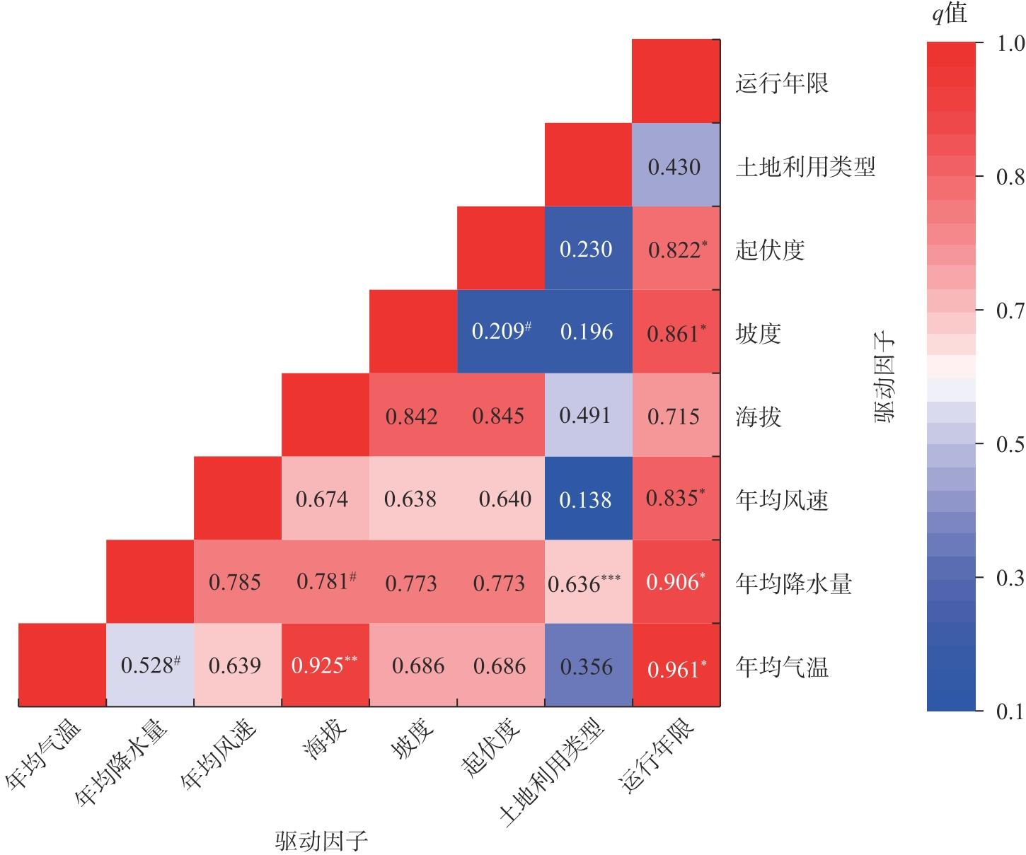
在“双碳”战略背景下,风力发电作为清洁可再生能源的代表,正快速向资源禀赋优越但生态脆弱的干旱区拓展。新疆是中国风能资源最为丰富的地区之一,其大规模风电开发对生态环境的潜在影响亟需量化评估。以新疆风电场为研究对象,基于2000—2023年中分辨率成像光谱仪(MODIS)数据与气象、地形、土地利用数据,运用遥感生态指数(RSEI)及地理探测器模型等方法,系统探究了风电场空间分布特征、生态环境变化趋势及驱动因素。结果表明:(1) 新疆风电场总体呈集群化分布,集中于哈密市、吐鲁番市、阿勒泰地区等中低海拔区域,选址主要受地形平缓性、土地利用类型与风能资源约束。(2) 2000—2023年,约81.8%的风电场区域RSEI呈下降趋势,生态质量总体稳定但局地退化显著。(3) 地理探测器分析显示,年均降水量(q=0.4522)与海拔(q=0.3949)是新疆风电场区域生态变化的主导因子,而年均气温、坡度与风电运行年限等因子交互作用显著,89.3%的组合呈非线性增强关系,揭示生态效应具有多因子耦合特征。研究在一定程度上可以弥补新疆风电场生态影响研究的不足,为新疆风电开发与生态保护协调管理及干旱区可再生能源生态评估提供科学依据。
焦视堂, 颜洋, 郑江华, 何莹, 巴比尔江·迪力夏提, 魏建新, 刘俊豪, 折勇睿. 新疆风电场对生态环境的影响特征及其驱动因素分析[J]. 干旱区地理, 2026, 49(9): 1840-1854.
JIAO Shitang, YAN Yang, ZHENG Jianghua, HE Ying, Babierjiang DILIXIATI, WEI Jianxin, LIU Junhao, SHE Yongrui. Impact characteristics and driving factors of wind farms on the ecological environment in Xinjiang[J]. Arid Land Geography, 2026, 49(9): 1840-1854.
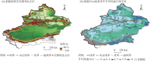
图1
研究区示意图 注:基于自然资源部标准地图服务网站审图号为GS(2024)0650号的标准地图制作,底图边界无修改。下同。"
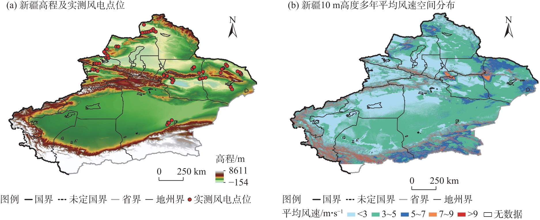

表1
主要数据来源"
| 数据 | 名称 | 年份 | 时间 分辨率 | 原始空间 分辨率 | 来源 |
|---|---|---|---|---|---|
| 地表温度 | 地表温度8 d合成产品(MOD11A2) | 2000—2025 | 8 d合成 | 1 km | 谷歌地球引擎(GEE) ( |
| 植被指数 | 植被指数16 d合成产品(MOD13A1) | 2000—2025 | 16 d合成 | 500 m | 美国国家航空航天局(NASA) ( |
| 短波红外波段 | 地表反射率8 d合成产品(MOD09A1) | 2000—2025 | 8 d合成 | 500 m | 美国国家航空航天局(NASA) ( |
| 气温 | 中国1 km分辨率逐月平均气温数据集 | 1901—2024 | 逐月 | 1 km | 国家青藏高原科学数据中心 ( |
| 降水 | 中国1 km分辨率逐月降水量数据集 | 1901—2024 | 逐月 | 1 km | 国家青藏高原科学数据中心 ( |
| 风速 | 多源数据融合的中国高分辨多要素气象驱动产品(ChinaMet) | 1980—2024 | 逐月 | 0.1° | 国家冰川冻土沙漠科学数据中心 ( |
| 海拔、坡度、 地形起伏度 | 航天飞机雷达地形测绘任务数字高程模型(SRTM DEM) | - | - | 30 m | 美国国家航空航天局(NASA) ( |
| 土地利用类型 | 30 m全球土地覆盖动态数据集 (GLC_FCS30D) | - | - | 30 m | Zenodo( |
| Sentinel-2 | 哥白尼Sentinel-2地表反射率产品(COPERNICUS_S2_SR_HARMONIZED) | 2023 | a | 10 m | 谷歌地球引擎(GEE) ( |
| 10 m风速 | 多年平均风速产品 | - | - | 10 m | 全球风能地图 ( |
表2
交互探测器的影响模式"
| 判断依据 | 交互作用类型 |
|---|---|
| q(x1∩x2)<Min[q(x1),q(x2)] | 非线性减弱 |
| Min[q(x1),q(x2)]<q(x1∩x2)<Max[q(x1),q(x2)] | 单因子非线性减弱 |
| q(x1∩x2)>Max[q(x1),q(x2)] | 双因子增强 |
| q(x1∩x2)=q(x1)+q(x2) | 独立 |
| q(x1∩x2)>q(x1)+q(x2) | 非线性增强 |
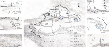
图2
新疆风电场空间分布 注:区域a~f表示新疆风电场分布区域,其空间位置见主图虚线框,两侧插图为对应区域局部放大图。下同。"

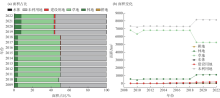
图3
2009—2022年新疆风电场区域土地利用类型占比及变化趋势"

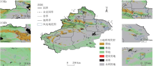
图4
新疆风电场在不同土地利用类型下的空间分布"
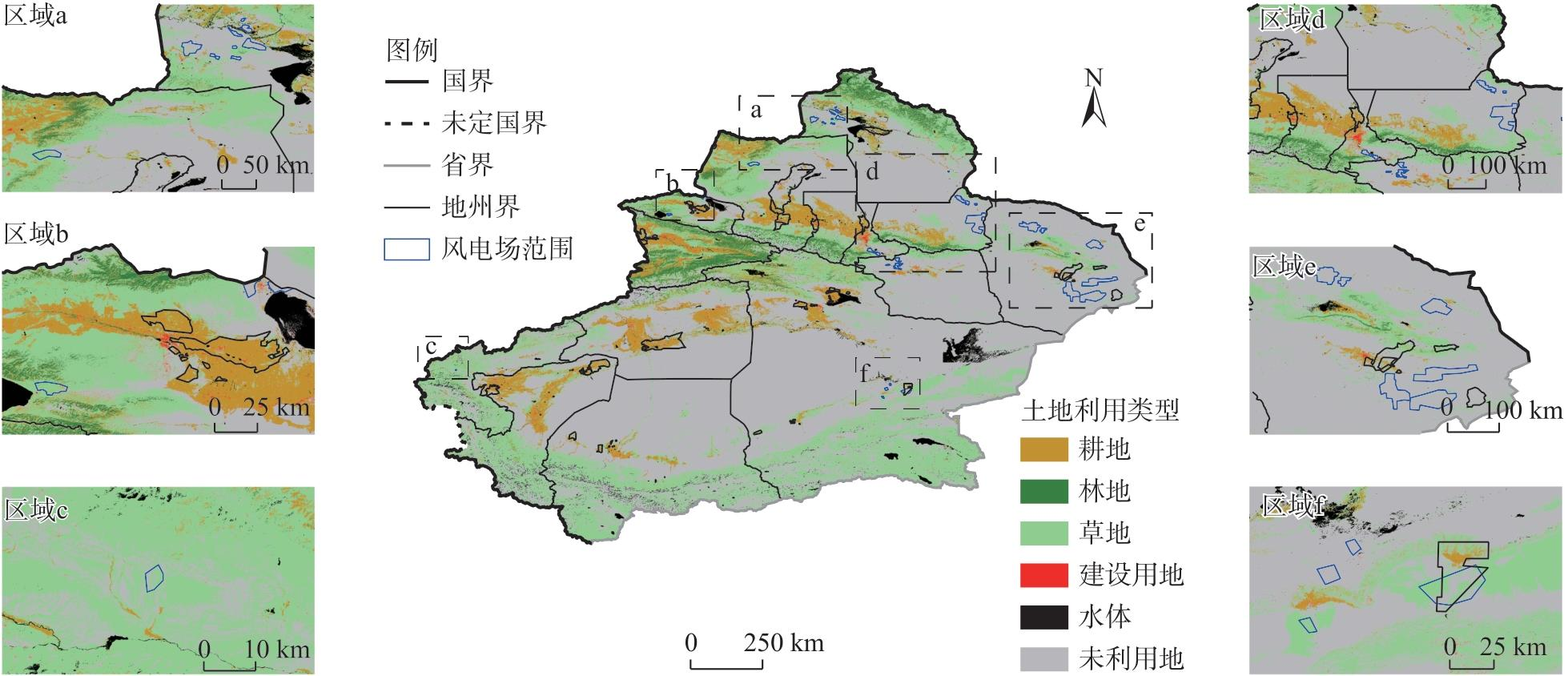
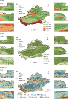
图5
新疆风电场在不同海拔、坡度、地貌类型的空间分布"

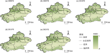
图6
2000—2023年新疆RSEI空间分布 注:RSEI为遥感生态环境指数。下同。"

表3
2000—2023年新疆风电场区域RSEI变化类型统计结果"
| 类别 | ΔRSEI范围 | 数量占比/% |
|---|---|---|
| 严重退化 | ΔRSEI<-0.05 | 3.0 |
| 轻微退化 | -0.05<ΔRSEI<0.00 | 78.8 |
| 基本稳定 | ΔRSEI=0 | 0.0 |
| 轻微改善 | 0.00<ΔRSEI<0.05 | 18.2 |
| 显著改善 | ΔRSEI>0.05 | 0.0 |
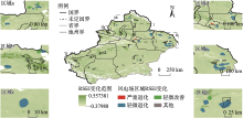
图7
新疆风电场区域RSEI变化的空间分布"

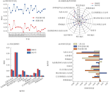
图8
2000年和2023年新疆各地州市及风电场区域的RSEI"
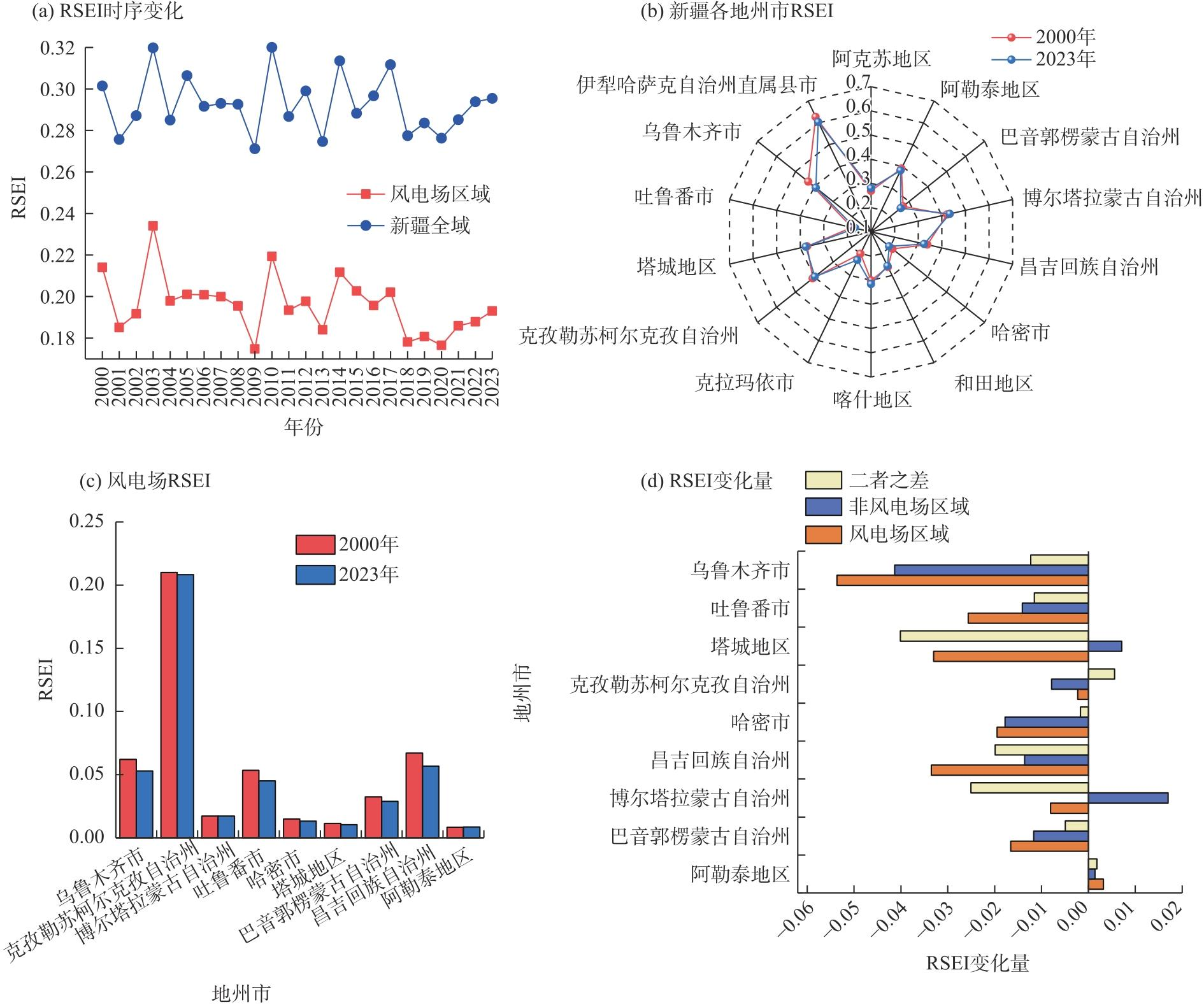
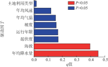
图9
单个驱动因子探测结果 注:P为统计检验结果的显著性概率;q为自变量对因变量的解释力。下同。"
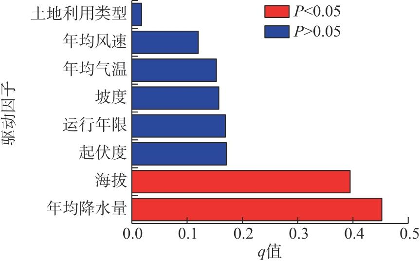
图10
各因子交互作用结果 注:*、**、***分别表示在0.01、0.05、0.001水平上显著;#表示双因子增强;其余为非线性增强。"
| [1] | Kemp L, Xu C, Depledge J, et al. Climate endgame: Exploring catastrophic climate change scenarios[J]. Proceedings of the National Academy of Sciences, 2022, 119(34): e2108146119, doi: 10.1073/pnas.2108146119. |
| [2] |
Xie C L, Sun Z F. Wind energy in China: Current scenario and future perspectives[J]. Renewable and Sustainable Energy Reviews, 2009, 13(8): 1966-1974.
doi: 10.1016/j.rser.2009.01.004 |
| [3] |
Howland M F, Lele S K, Dabiri J O. Wind farm power optimization through wake steering[J]. Proceedings of the National Academy of Sciences, 2019, 116(29): 14495-14500.
doi: 10.1073/pnas.1903680116 |
| [4] |
Liu L Y, Liu P T, Yu J W, et al. Wind farms increase land surface temperature and reduce vegetation productivity in the Inner Mongolia[J]. Geography and Sustainability, 2024, 5(3): 319-328.
doi: 10.1016/j.geosus.2024.01.007 |
| [5] |
Baidya R S, Traiteur J J. Impacts of wind farms on surface air temperatures[J]. Proceedings of the National Academy of Sciences, 2010, 107(42): 17899-17904.
doi: 10.1073/pnas.1000493107 |
| [6] | 刘朋涛. 内蒙古风电场景观格局演变及生态效应[D]. 呼和浩特: 内蒙古大学, 2021. |
| [Liu Pengtao. Evolution of landscape pattern and ecological effects of wind farms in Inner Mongolia[D]. Hohhot: Inner Mongolia University, 2021.] | |
| [7] |
蒋俊霞, 杨丽薇, 李振朝, 等. 风电场对气候环境的影响研究进展[J]. 地球科学进展, 2019, 34(10): 1038-1049.
doi: 10.11867/j.issn.1001-8166.2019.10.1038 |
|
[Jiang Junxia, Yang Liwei, Li Zhenchao, et al. Research progress on the impacts of wind farms on climatic environment[J]. Advances in Earth Science, 2019, 34(10): 1038-1049.]
doi: 10.11867/j.issn.1001-8166.2019.10.1038 |
|
| [8] | 李薇, 龚奂彰, 臧宏宽, 等. 风电场对区域及全球气候的影响研究进展[J]. 环境保护, 2018, 46(3): 69-73. |
| [Li Wei, Gong Huanzhang, Zang Hongkuan, et al. Research progress on the impacts of wind farms on regional and global climate[J]. Environmental Protection, 2018, 46(3): 69-73.] | |
| [9] | 王刚, 赵玉梅, 董丽, 等. 风力发电机对荒漠草原地表温度及蒸散发的影响[J]. 地理信息世界, 2021, 28(2): 74-81. |
| [Wang Gang, Zhao Yumei, Dong Li, et al. Impacts of wind turbines on land surface temperature and evapotranspiration in desert grasslands[J]. World of Geographical Information, 2021, 28(2): 74-81.] | |
| [10] | 马兴悦. 基于卫星遥感资料的河北坝上风电场对地表温度和植被的影响研究[D]. 兰州: 兰州大学, 2022. |
| [Ma Xingyue. Study on the impacts of wind farms on land surface temperature and vegetation in Bashang area of Hebei based on satellite remote sensing data[D]. Lanzhou: Lanzhou University, 2022.] | |
| [11] |
贾馨, 李国庆, 王刚, 等. 风电场对草地土壤湿度的影响[J]. 干旱区地理, 2021, 44(4): 1125-1134.
doi: 10.12118/j.issn.1000–6060.2021.04.24 |
|
[Jia Xin, Li Guoqing, Wang Gang, et al. Impacts of wind farms on soil moisture in grasslands[J]. Arid Land Geography, 2021, 44(4): 1125-1134.]
doi: 10.12118/j.issn.1000–6060.2021.04.24 |
|
| [12] |
Zhou L M, Tian Y H, Baidya R S, et al. Impacts of wind farms on land surface temperature[J]. Nature Climate Change, 2012, 2(7): 539-543.
doi: 10.1038/nclimate1505 |
| [13] | Qin Y Z, Li Y, Xu R, et al. Impacts of 319 wind farms on surface temperature and vegetation in the United States[J]. Environmental Research Letters, 2022, 17(2): 024026, doi: 10.1088/1748-9326/ac49ba. |
| [14] | Liu N J, Zhao X, Zhang X, et al. Remotely sensed evidence of the divergent climate impacts of wind farms on croplands and grasslands[J]. Science of the Total Environment, 2023, 905: 167203, doi: 10.1016/j.scitotenv.2023.167203. |
| [15] |
Slawsky L M, Zhou L, Baidya Roy S, et al. Observed thermal impacts of wind farms over northern Illinois[J]. Sensors, 2015, 15(7): 14981-15005.
doi: 10.3390/s150714981 pmid: 26121613 |
| [16] | Xia G, Zhou L M. Detecting wind farm impacts on local vegetation growth in Texas and Illinois using MODIS vegetation greenness measurements[J]. Remote Sensing, 2017, 9(7): 698, doi: 10.3390/rs9070698. |
| [17] | Han X H, Lu C, Wang J. Long-term impacts of 250 wind farms on surface temperature and vegetation in China: A remote sensing analysis[J]. Remote Sensing, 2024, 17(1): 10, doi: 10.3390/rs17010010. |
| [18] | Xu K, He L C, Hu H J, et al. Positive ecological effects of wind farms on vegetation in China’s gobi desert[J]. Scientific Reports, 2019, 9(1): 6341, doi: 10.1038/s41598-019-42569-0. |
| [19] |
Fei T T, Lu D G, Li Y, et al. The impact of the wind farm on the vegetation and the microclimate via remote sensing: A case study in Hebei Province, China[J]. Energy, Ecology and Environment, 2026, 11(2): 215-232.
doi: 10.1007/s40974-025-00386-4 |
| [20] | Wang G, Li G Q, Liu Z. Wind farms dry surface soil in temporal and spatial variation[J]. Science of the Total Environment, 2023, 857: 159293, doi: 10.1016/j.scitotenv.2022.159293. |
| [21] |
孙桂丽, 陆海燕, 郑佳翔, 等. 新疆生态脆弱性时空演变及驱动力分析[J]. 干旱区研究, 2022, 39(1): 258-269.
doi: 10.13866/j.azr.2022.01.25 |
|
[Sun Guili, Lu Haiyan, Zheng Jiaxiang, et al. Spatio-temporal evolution and driving force analysis of ecological vulnerability in Xinjiang[J]. Arid Zone Research, 2022, 39(1): 258-269.]
doi: 10.13866/j.azr.2022.01.25 |
|
| [22] | Xu H Q. A remote sensing index for assessment of regional ecological changes[J]. China Environmental Science, 2013, 33(5): 889-897. |
| [23] | Aizizi Y, Kasimu A, Liang H W, et al. Evaluation of ecological quality status and changing trend in arid land based on the remote sensing ecological index: A case study in Xinjiang, China[J]. Forests, 2023, 14(9): 1830, doi: 10.3390/f14091830. |
| [24] |
Yao K X, Halike A, Chen L M, et al. Spatiotemporal changes of eco-environmental quality based on remote sensing-based ecological index in the Hotan Oasis, Xinjiang[J]. Journal of Arid Land, 2022, 14(3): 262-283.
doi: 10.1007/s40333-022-0011-2 |
| [25] | Shi M, Lin F, Jing X, et al. Ecological environment quality assessment of arid areas based on improved remote sensing ecological index: A case study of the Loess Plateau[J]. Sustainability, 2023, 15(18): 13881, doi: 10.3390/su151813881. |
| [26] | Duo L H, Wang J Q, Zhang F Q, et al. Assessing the spatiotemporal evolution and drivers of ecological environment quality using an enhanced remote sensing ecological index in Lanzhou City, China[J]. Remote Sensing, 2023, 15(19): 4704, doi: 10.3390/rs15194704. |
| [27] | 杜文杰, 关梦茜, 江源, 等. 新疆风力发电减碳效益全生命周期评估[J]. 生态学报, 2024, 44(8): 3293-3302. |
| [Du Wenjie, Guan Mengxi, Jiang Yuan, et al. Life cycle assessment of carbon reduction benefits of wind power generation in Xinjiang[J]. Acta Ecologica Sinica, 2024, 44(8): 3293-3302.] | |
| [28] | Jiang H N, Xie M Y, Li X, et al. Wind farms impacts on land surface temperature and its driving factors in an arid area of Xinjiang, China[J]. Sustainability, 2025, 17(21): 9445, doi: 10.3390/su17219445. |
| [29] | 谢彦峰. 干旱区风力发电建设区域水土流失量测评[J]. 水土保持, 2024, 12(4): 50-55. |
|
[Xie Yanfeng. Assessment of soil erosion in wind power construction areas in arid regions[J]. Open Journal of Soil and Water Conservation, 2024, 12(4): 50-55.]
doi: 10.12677/ojswc.2024.124007 |
|
| [30] | 艾丽菲热·吾马尔. 气候变化背景下新疆生态系统服务功能评估与模拟[D]. 南京: 南京信息工程大学, 2025. |
| [Wumar Alifire. Assessment and simulation of ecosystem service functions in Xinjiang under the background of climate change[D]. Nanjing: Nanjing University of Information Science and Technology, 2025.] | |
| [31] | Dilixiati B, Wang H W, Gong L C, et al. Land use dynamics and ecological effects of photovoltaic development in Xinjiang: A remote sensing and geospatial analysis[J]. Land, 2025, 14(6): 1294, doi: 10.3390/land14061294. |
| [32] | Han W Q, Guan J Y, Zheng J H, et al. Probabilistic assessment of drought stress vulnerability in grasslands of Xinjiang, China[J]. Frontiers in Plant Science, 2023, 14: 1143863, doi: 10.3389/fpls.2023.1143863. |
| [33] | 肖杨. 新疆不同区域风电场风能资源对比分析[J]. 中国水能及电气化, 2021(1): 48-51. |
| [Xiao Yang. Comparative analysis of wind energy resources of wind farms in different regions of Xinjiang[J]. China Water Power & Electrification, 2021(1): 48-51.] | |
| [34] | 贾杰斌, 李钢, 阎肃, 等. 新疆九大风区再认识及三个新风区划定[J]. 风能, 2023(2): 54-60. |
| [Jia Jiebin, Li Gang, Yan Su, et al. New understanding of nine major wind zones and delineation of three new wind areas in Xinjiang[J]. Wind Energy, 2023(2): 54-60.] | |
| [35] | 彭守璋. 中国1 km分辨率逐月平均气温数据集(1901-2024)[DB/OL]. 国家青藏高原科学数据中心. [2025-07-02]. https://doi.org/10.11888/Meteoro.tpdc.270961. |
| [Peng Shouzhang. 1-km mon-thly mean temperature dataset for China (1901-2024)[DB/OL]. National Tibetan Plateau/Third Pole Environment Data Center. [2025-07-02]. https://doi.org/10.11888/Meteoro.tpdc.270961.] | |
| [36] | 彭守璋. 中国1 km 分辨率逐月降水量数据集(1901-2024)[DB/OL]. 国家青藏高原科学数据中心. [2025-07-02]. https://doi.org/10.5281/zenodo.3114194. |
| [Peng Shouzhang. 1-km monthly precipitation dataset for China (1901-2024)[DB/OL]. National Tibetan Plateau/Third Pole Environment Data Center. [2025-07-02]. https://doi.org/10.5281/zenodo.3114194.] | |
| [37] | 张凌, 胡英屹, 赵彦博, 等. 多源数据融合的中国高分辨多要素气象驱动产品(ChinaMet)[DB/OL]. 国家冰川冻土沙漠科学数据中心. [2025-09-02]. https://cstr.cn/CSTR:11738.11.NCDC.NIEER.DB-6722.2025. |
| [Zhang Ling, Hu Yingyi, Zhao Yanbo, et al. China high-resolution multi-factor meteorological driving product (ChinaMet) based on multi-source data fusion[DB/OL]. National Glacial, Permafrost and Desert Data Center. [2025-09-02]. https://cstr.cn/CSTR:11738.11.NCDC.NIEER.DB6722.2025.] | |
| [38] |
Zhang X, Liu L Y, Chen X D, et al. GLC_FCS30: Global land-cover product with fine classification system at 30 m using time-series Landsat imagery[J]. Earth System Science Data, 2021, 13(6): 2753-2776.
doi: 10.5194/essd-13-2753-2021 |
| [39] | 李国庆, 刘志锋, 常学礼, 等. 风电场对草地蒸散发影响分析[J]. 生态科学, 2016, 35(6): 146-151. |
| [Li Guoqing, Liu Zhifeng, Chang Xueli, et al. Analysis of the impact of wind farms on grassland evapotranspiration[J]. Ecological Science, 2016, 35(6): 146-151.] | |
| [40] | Xu H Q, Wang Y F, Guan H D, et al. Detecting ecological changes with a remote sensing based ecological index (RSEI) produced time series and change vector analysis[J]. Remote Sensing, 2019, 11(20): 2345, doi: 10.3390/rs11202345. |
| [41] |
Chander G, Markham B L, Helder D L. Summary of current radiometric calibration coefficients for Landsat MSS, TM, ETM+, and EO-1 ALI sensors[J]. Remote Sensing of Environment, 2009, 113(5): 893-903.
doi: 10.1016/j.rse.2009.01.007 |
| [42] | Xu H Q. Creation and application of urban remote sensing ecological index[J]. Acta Ecologica Sinica, 2013, 33(24): 7853-7862. |
| [43] |
孙瑞, 金晓斌, 蒋宇超, 等. 热带海岛规模性土地整治项目区生态质量变化过程与特征分析[J]. 地理研究, 2021, 40(8): 2331-2346.
doi: 10.11821/dlyj020200851 |
| [Sun Rui, Jin Xiaobin, Jiang Yuchao, et al. Process and characteristics of ecological quality changes in large-scale land consolidation project areas on tropical islands[J]. Geographical Research, 2021, 40(8): 2331-2346.] | |
| [44] |
王劲峰, 徐成东. 地理探测器: 原理与展望[J]. 地理学报, 2017, 72(1): 116-134.
doi: 10.11821/dlxb201701010 |
|
[Wang Jinfeng, Xu Chengdong. Geodetector: Principle and prospects[J]. Acta Geographica Sinica, 2017, 72(1): 116-134.]
doi: 10.11821/dlxb201701010 |
|
| [45] | 吕泳洁, 丁文广, 邓喆, 等. 基于地理探测器的甘肃省植被覆盖时空变化及驱动力分析[J]. 地球环境学报, 2022, 13(2): 185-195. |
| [Lü Yongjie, Ding Wenguang, Deng Zhe, et al. Spatiotemporal variation and driving force analysis of vegetation coverage in Gansu Province based on the geographical detector[J]. Journal of Earth Environment, 2022, 13(2): 185-195.] | |
| [46] | Zhu L J, Meng J J, Zhu L K. Applying geodetector to disentangle the contributions of natural and anthropogenic factors to NDVI variations in the middle reaches of the Heihe River Basin[J]. Ecological Indicators, 2020, 117: 106545, doi: 10.1016/j.ecolind.2020.106545. |
| [47] | Zhang S H, Zhou Y K, Yu Y, et al. Using the geodetector method to characterize the spatiotemporal dynamics of vegetation and its interaction with environmental factors in the Qinba Mountains, China[J]. Remote Sensing, 2022, 14(22): 5794, doi: 10.3390/rs1-4225794. |
| [48] | 罗清, 张靖, 鲍雅静, 等. 基于RSEI的辽河流域生态环境动态变化,归因及分区研究[J]. 水土保持通报, 2025, 45(2): 360-370. |
| [Luo Qing, Zhang Jing, Bao Yajing, et al. Dynamic change, attribution, and regionalization of the ecological environment in the Liaohe River Basin based on RSEI[J]. Bulletin of Soil & Water Conservation, 2025, 45(2): 360-370.] | |
| [49] | 高焕霖, 张廷龙, 樊华烨, 等. 基于地理探测器的杨凌示范区生态环境质量影响因素定量分析[J]. 西北林学院学报, 2020, 35(5): 185-194. |
| [Gao Huanlin, Zhang Tinglong, Fan Huaye, et al. Quantitative analysis of factors influencing ecological environment quality in the Yangling demonstration zone based on the geographical detector[J]. Journal of Northwest Forestry University, 2020, 35(5): 185-194.] | |
| [50] |
于昊辰, 尹登玉, 宫攀, 等. 干旱区山水林田湖草沙冰一体化保护与系统治理——基于土地退化平衡视角[J]. 自然资源学报, 2024, 39(9): 2066-2086.
doi: 10.31497/zrzyxb.20240904 |
|
[Yu Haochen, Yin Dengyu, Gong Pan, et al. Integrated protection and systematic management of mountain-water-forest-field-lake-grass-desert-ice systems in arid regions: From the perspective of land degradation neutrality[J]. Journal of Natural Resources, 2024, 39(9): 2066-2086.]
doi: 10.31497/zrzyxb.20240904 |
|
| [51] | 汤恒睿, 叶恩童, 娄星驰, 等. 干旱区植被对水分胁迫的响应特征分析[J]. 地球与环境, 2026, 54(3): 486-500. |
|
[Tang Hengrui, Ye Entong, Lou Xingchi, et al. Analysis of vegetation response characteristics to water stress in arid regions[J]. Earth and Environment, 2026, 54(3): 486-500.]
doi: 10.3724/EE.1672-9250.2025.53.086 |
|
| [52] | 张文佳, 张永战. 中国风电的时空分布特征和发展趋势[J]. 自然资源学报, 2007, 22(4): 585-595. |
| [Zhang Wenjia, Zhang Yongzhan. Spatiotemporal distribution characteristics and development trends of wind power in China[J]. Journal of Natural Resources, 2007, 22(4): 585-595.] | |
| [53] | Wu J W, Xiao J Y, Hou J M, et al. Development potential assessment for wind and photovoltaic power energy resources in the main desert-gobi-wilderness areas of China[J]. Energies, 2023, 16(12): 4559, doi: 10.3390/en16124559. |
| [54] | Su N, Li X B, Lü X, et al. Comprehensive assessment of the climatic and vegetation impacts of wind farms on grasslands: A case study in Inner Mongolia, China[J]. Journal of Environmental Management, 2024, 370: 122430, doi: 10.1016/j.jenvman.2024.122-430. |
| [55] | 何则, 赵勇强, 袁婧婷. 生态环境友好型风电场规划管理的国际经验与政策启示[J]. 中国能源, 2021, 43(12): 74-82. |
| [He Ze, Zhao Yongqiang, Yuan Jingting. International experience and policy implications of eco-friendly wind farm planning and management[J]. China Energy, 2021, 43(12): 74-82.] | |
| [56] | 刘玉佳. 库鲁斯台草原生态保护修复效果评估与变化驱动分析[D]. 乌鲁木齐: 新疆大学, 2023. |
| [Liu Yujia. Evaluation of ecological protection and restoration effects and analysis of change drivers in the Kurustai grassland[D]. Urumqi: Xinjiang University, 2023.] | |
| [57] |
张秀霞, 韩丽莎, 党星海, 等. 西北干旱区近30 a植被覆盖的时空变化及其对气候因子的响应[J]. 干旱区研究, 2025, 42(6): 1067-1079.
doi: 10.13866/j.azr.2025.06.10 |
|
[Zhang Xiuxia, Han Lisha, Dang Xinghai, et al. Spatiotemporal variation of vegetation coverage and its response to climatic factors in arid regions of northwest China over the past 30 years[J]. Arid Zone Research, 2025, 42(6): 1067-1079.]
doi: 10.13866/j.azr.2025.06.10 |
|
| [58] | 吴建国, 巩倩, 王阳. 风电场对生态系统、生物多样性及环境的影响[J]. 生态经济, 2023, 39(9): 167-178, 229. |
|
[Wu Jianguo, Gong Qian, Wang Yang. Impacts of wind farms on ecosystems, biodiversity, and the environment[J]. Ecological Economy, 2023, 39(9): 167-178, 229.]
doi: 10.1016/S0921-8009(01)00225-7 |
|
| [59] | 王志科, 张嘉宸, 李廷山, 等. 高海拔地区风电场建设对环境的影响及水土保持对策探讨——以共和县切吉乡1000 MW风电项目为例[J]. 绿色科技, 2020(20): 140-142. |
| [Wang Zhike, Zhang Jiachen, Li Tingshan, et al. Environmental impacts of wind farm construction in high-altitude areas and soil and water conservation countermeasures: A case study of the 1000 MW wind power project in Qieji Township, Gonghe County[J]. Green Technology, 2020(20): 140-142.] | |
| [60] | Zhang W J, Zhang Y Z. Studies on characteristics of the spatial-temporal distribution and development trend for wind farms in China[J]. Journal of Natural Resources, 2007, 22(4): 585-595. |
| [61] | Zhang Y L, Long A H, Lü T B, et al. Trends, cycles, and spatial distribution of the precipitation, potential evapotranspiration and aridity index in Xinjiang, China[J]. Water, 2022, 15(1): 62, doi: 10.3390/w15010062. |
| [62] | Sui X R, Xu Q L, Tao H, et al. Vegetation dynamics and recovery potential in arid and semi-arid northwest China[J]. Plants, 2024, 13(23): 3412, doi: 10.3390/plants13233412. |
| [63] | Seifert L, Graae B J, Hagen D, et al. The emerging need for ecosystem restoration to mitigate the impacts of onshore wind energy[J]. Sustainable Environment, 2025, 11(1): 2567100, doi: 10.1080/27658511.2025.2567100. |
| [64] | Zhang J, Zhang P, Deng X Y, et al. Study on the spatial and temporal trends of ecological environment quality and influencing factors in Xinjiang oasis[J]. Remote Sensing, 2024, 16(11): 1980, doi: 10.3390/rs16111980. |
| [65] | Wang H Q, Sun B P, Yu X X, et al. The driver-pattern-effect connection of vegetation dynamics in the transition area between semi-arid and semi-humid northern China[J]. Catena, 2020, 194: 104-713, doi: 10.1016/j.catena.2020.104713. |
| [66] | Li Y, Xie W Q, Zhang J D, et al. Spatiotemporal changes and driving factors of ecological environmental quality in the Yongding-Luan River Basin based on RSEI[J]. Frontiers in Environmental Science, 2024, 12: 1494098, doi: 10.3389/fenvs.2024.1494098. |
| [67] | Bai X Y, Fan Z M, Yue T X. Dynamic pattern-effect relationships between precipitation and vegetation in the semi-arid and semi-humid area of China[J]. Catena, 2023, 232: 107425, doi: 10.1016/j.catena.2023.107425. |
| [1] | 李晓鹏, 贾富贵, 雷双, 李康. 黄河流域农作物受灾时空演变特征及致灾因子[J]. 干旱区地理, 2026, 49(9): 1815-1825. |
| [2] | 毕文焌, 闫庆武, 赵甫心, 移明昊, 吴子豪. 基于XGBoost-SHAP方法的天山中段景观生态风险时空演变及驱动因素[J]. 干旱区地理, 2026, 49(9): 1826-1839. |
| [3] | 蒋志辉, 琚慧琦, 欧阳金琼, 苏旭峰. 组态视角下新疆农业生产水足迹治理的多重路径[J]. 干旱区地理, 2026, 49(9): 1951-1964. |
| [4] | 仝雁军, 袁露, 雷军. 边疆安全背景下新疆边境人口-社会经济-资源环境耦合协调关系研究[J]. 干旱区地理, 2026, 49(8): 1626-1639. |
| [5] | 李森, 鱼腾飞, 赵鸿雁, 张志山, 颜长珍. 近50 a宁夏中部干旱带沙漠化时空变化及其逆转期驱动力[J]. 干旱区地理, 2026, 49(8): 1663-1674. |
| [6] | 罗庆, 臧永婷, 王云龙, 王山冰, 刘乐. 黄河流域乡镇人口分布格局的演变特征及其驱动机制[J]. 干旱区地理, 2026, 49(8): 1711-1723. |
| [7] | 路知秋, 律名扬, 李智慧, 徐丽萍. “人-地-业”视角下新疆城乡融合发展的多维评价与时空演化[J]. 干旱区地理, 2026, 49(8): 1750-1763. |
| [8] | 陈先林, 闫志远, 刘全明, 张圣微. 1958—2023年内蒙古植被干旱时空特征与驱动因素分析[J]. 干旱区地理, 2026, 49(7): 1323-1335. |
| [9] | 王紫洋, 夏咏, 王福红, 丁宁, 吕毅, 苏泽琛. 新疆县域耕地利用生态效率时空演变及驱动因素[J]. 干旱区地理, 2026, 49(7): 1385-1394. |
| [10] | 宁雅萱, 尹豪, 李金诺. 中国北方农牧交错带中段新型城镇化与农业生态系统服务耦合分析[J]. 干旱区地理, 2026, 49(7): 1457-1469. |
| [11] | 李文君, 张维梅. 中国数字经济与共同富裕的耦合协调关系及时空演进趋势[J]. 干旱区地理, 2026, 49(7): 1481-1492. |
| [12] | 陈亚宁, 朱成刚, 李稚, 方功焕. 新疆高质量发展的水资源潜力挖掘分析[J]. 干旱区地理, 2026, 49(6): 1101-1107. |
| [13] | 朱怡婷, 杜跃, 周雨乾, 何雄, 周春山, 陈泓睿. 基于社交媒体数据的“网红打卡地”空间特征及影响因素[J]. 干旱区地理, 2026, 49(6): 1264-1276. |
| [14] | 刘潇, 张新焕, 陈洋, 闫海龙. “乡镇-县域-绿洲”视角下新疆城乡融合的空间条件测度研究[J]. 干旱区地理, 2026, 49(5): 1039-1051. |
| [15] | 吕宛青, 宋志高, 肖钊富. 中国新型城镇化与旅游业高质量发展耦合协调、障碍诊断及驱动因素[J]. 干旱区地理, 2026, 49(5): 1063-1073. |
|
||

