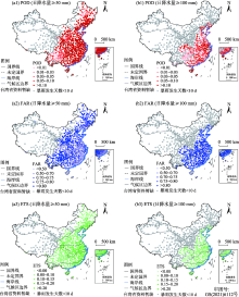
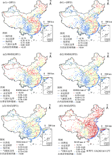
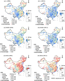
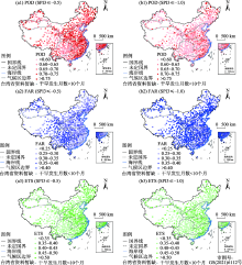
| [1] |
夏军, 谈戈. 全球变化与水文科学新的进展与挑战[J]. 资源科学, 2002, 24(3):1-7.
|
|
[Xia Jun, Tan Ge. Hydrological science towards global change: Progress and challenge[J]. Resources Science, 2002, 24(3):1-7. ]
|
| [2] |
Adler R F, Huffman G J, Chang A, et al. The version-2 global precipitation climatology project (GPCP) monthly precipitation analysis (1979-present)[J]. Journal of hydrometeorology, 2003, 4(6):1147-1167.
doi: 10.1175/1525-7541(2003)004<1147:TVGPCP>2.0.CO;2
|
| [3] |
谈戈, 夏军, 李新. 无资料地区水文预报研究的方法与出路[J]. 冰川冻土, 2004, 26(2):192-196.
|
|
[Tan Ge, Xia Jun, Li Xin. Hydrological prediction in ungauged basins[J]. Journal of Glaciology and Geocryology, 2004, 26(2):192-196. ]
|
| [4] |
Su F, Hong Y, Lettenmaier D P. Evaluation of TRMM multisatellite precipitation analysis (TMPA) and its utility in hydrologic prediction in the La Plata Basin[J]. Journal of Hydrometeorology, 2008, 9(4):622-640.
doi: 10.1175/2007JHM944.1
|
| [5] |
黄建平, 张国龙, 于海鹏, 等. 黄河流域近40年气候变化的时空特征[J]. 水利学报, 2020, 51(9):1048-1058.
|
|
[Huang Jianping, Zhang Guolong, Yu Haipeng, et al. Characteristics of climate change in the Yellow River Basin during recent 40 years[J]. Journal of Hydraulic Engineering, 2020, 51(9):1048-1058. ]
|
| [6] |
黄颖, 毛文茜, 王潇雅, 等. 近39 a祁连山及其周边地区降水量时空分布特征[J]. 干旱气象, 2020, 38(4):527-534.
|
|
[Huang Ying, Mao Wenqian, Wang Xiaoya, et al. Temporal and spatial distribution of precipitation in the Qilian Mountain and its surrounding areas in recent 39 years[J]. Journal of Arid Meteorology, 2020, 38(4):527-534. ]
|
| [7] |
赵建婷, 王艳君, 苏布达, 等. 印度河流域气温、降水、蒸发及干旱变化特征[J]. 干旱区地理, 2020, 43(2):72-82.
|
|
[Zhao Jianting, Wang Yanjun, Su Buda, et al. Spatiotemporal distributions of temperature, precipitation, evapotranspiration, and drought in the Indus River Basin[J]. Arid Land Geography, 2020, 43(2):72-82. ]
|
| [8] |
徐昆, 朱秀芳, 刘莹, 等. 采用AquaCrop作物生长模型研究中国玉米干旱脆弱性[J]. 农业工程学报, 2020, 36(1):154-161.
|
|
[Xu Kun, Zhu Xiufang, Liu Ying, et al. Vulnerability of drought disaster of maize in China based on AquaCrop model[J]. Transactions of the Chinese Society of Agricultural Engineering, 2020, 36(1):154-161. ]
|
| [9] |
徐昆, 朱秀芳, 刘莹, 等. 气候变化下干旱对中国玉米产量的影响[J]. 农业工程学报, 2020, 36(11):149-158.
|
|
[Xu Kun, Zhu Xiufang, Liu Ying, et al. Effects of drought on maize yield under climate change in China[J]. Transactions of the Chinese Society of Agricultural Engineering, 2020, 36(11):149-158. ]
|
| [10] |
张小丽, 彭勇, 王本德, 等. 基于SWAT模型的降雨数据适用性评价[J]. 农业工程学报, 2014, 30(19):88-96.
|
|
[Zhang Xiaoli, Peng Yong, Wang Bende, et al. Suitability evaluation of precipitation data using SWAT model[J]. Transactions of the Chinese Society of Agricultural Engineering, 2014, 30(19):88-96. ]
|
| [11] |
焦振航, 舒红, 吴凯, 等. 降水驱动数据改进对VIC土壤湿度模拟的影响[J]. 城市勘测, 2017(4):37-41.
|
|
[Jiao Zhenhang, Shu Hong, Wu Kai, et al. The rainfall calibration methods’ impact on VIC soil moisture simulation[J]. Urban Surveying, 2017(4):37-41. ]
|
| [12] |
Tarek M, Brissette F P, Arsenault R. Evaluation of the ERA5 reanalysis as a potential reference dataset for hydrological modelling over North America[J]. Hydrology and Earth System Sciences, 2020, 24(5):2527-2544.
doi: 10.5194/hess-24-2527-2020
|
| [13] |
冯克鹏, 洪阳, 田军仓, 等. 多源降水数据的小流域水文模拟效用评估[J]. 干旱区地理, 2020, 43(5):1179-1191.
|
|
[Feng Kepeng, Hong Yang, Tian Juncang, et al. Evaluating runoff simulation of multi-source precipitation data in small watersheds[J]. Arid Land Geography, 2020, 43(5):1179-1191. ]
|
| [14] |
Albergel C, Dutra E, Munier S, et al. ERA-5 and ERA-Interim driven ISBA land surface model simulations: Which one performs better?[J]. Hydrology and Earth System Sciences, 2018, 22(6):3515-3532.
doi: 10.5194/hess-22-3515-2018
|
| [15] |
韦芬芬, 汤剑平, 王淑瑜. 中国区域夏季再分析资料高空变量可信度的检验[J]. 地球物理学报, 2015, 58(2):383-397.
|
|
[Wei Fenfen, Tang Jianping, Wang Shuyu. A reliability assessment of upper-level reanalysis datasets over China[J]. Chinese Journal of Geophysics, 2015, 58(2):383-397. ]
|
| [16] |
胡增运, 倪勇勇, 邵华, 等. CFSR, ERA-Interim和MERRA降水资料在中亚地区的适用性[J]. 干旱区地理, 2013, 36(4):700-708.
|
|
[Hu Zengyun, Ni Yongyong, Shao Hua, et al. Applicability study of CFSR, ERA-Interim and MERRA precipitation estimates in Central Asia[J]. Arid Land Geography, 2013, 36(4):700-708. ]
|
| [17] |
Hersbach H, Bell B, Berrisford P, et al. The ERA5 global reanalysis[J]. Quarterly Journal of the Royal Meteorological Society, 2020, 146(730):1999-2049.
doi: 10.1002/qj.v146.730
|
| [18] |
Graham R M, Hudson S R, Maturilli M. Improved performance of ERA5 in Arctic gateway relative to four global atmospheric reanalyses[J]. Geophysical Research Letters, 2019, 46(11):6138-6147.
doi: 10.1029/2019GL082781
|
| [19] |
Hénin R, Liberato M L, Ramos A M, et al. Assessing the use of satellite-based estimates and high-resolution precipitation datasets for the study of extreme precipitation events over the Iberian Peninsula[J]. Water, 2018, 10(11):1688, doi: 10.3390/w10111688.
doi: 10.3390/w10111688
|
| [20] |
Wang C, Graham R M, Wang K, et al. Comparison of ERA5 and ERA-Interim near-surface air temperature, snowfall and precipitation over Arctic sea ice: Effects on sea ice thermodynamics and evolution[J]. The Cryosphere, 2019, 13(6):1661-1679.
doi: 10.5194/tc-13-1661-2019
|
| [21] |
Betts A K, Chan D Z, Desjardins R L. Near-surface biases in ERA5 over the Canadian prairies[J]. Frontiers in Environmental Science, 2019, 7:129, doi: 10.3389/fenvs.2019.00129.
doi: 10.3389/fenvs.2019.00129
|
| [22] |
Beck H E, Pan M, Roy T, et al. Daily evaluation of 26 precipitation datasets using Stage-IV gauge-radar data for the CONUS[J]. Hydrology and Earth System Sciences, 2019, 23(1):207-224.
doi: 10.5194/hess-23-207-2019
|
| [23] |
Nogueira M. Inter-comparison of ERA-5, ERA-interim and GPCP rainfall over the last 40 years: Process-based analysis of systematic and random differences[J]. Journal of Hydrology, 2020, 583:124632, doi: 10.1016/j.jhydrol.2020.124632.
doi: 10.1016/j.jhydrol.2020.124632
|
| [24] |
Xu X, Frey S K, Boluwade A, et al. Evaluation of variability among different precipitation products in the Northern Great Plains[J]. Journal of Hydrology: Regional Studies, 2019, 24:100608, doi: 10.1016/j.ejrh.2019.100608.
doi: 10.1016/j.ejrh.2019.100608
|
| [25] |
Amjad M, Yilmaz M T, Yucel I, et al. Performance evaluation of satellite-and model-based precipitation products over varying climate and complex topography[J]. Journal of Hydrology, 2020, 584:124707, doi: 10.1016/j.jhydrol.2020.124632.
doi: 10.1016/j.jhydrol.2020.124632
|
| [26] |
Fallah A, Rakhshandehroo G R, Berg P, et al. Evaluation of precipitation datasets against local observations in southwestern Iran[J]. International Journal of Climatology, 2020, 40(9):4102-4116.
doi: 10.1002/joc.v40.9
|
| [27] |
Jiang Q, Li W, Fan Z, et al. Evaluation of the ERA5 reanalysis precipitation dataset over Chinese Mainland[J]. Journal of Hydrology, 2020: 125660, doi: 10.1016/j.jhydrol.2020.125660.
doi: 10.1016/j.jhydrol.2020.125660
|
| [28] |
成晓裕, 王艳华, 李国春, 等. 三套再分析降水资料在中国区域的对比评估[J]. 气候变化研究进展, 2013, 9(4):258-265.
|
|
[Cheng Xiaoyu, Wang Yanhua, Li Guochun, et al. Evaluation of three reanalysis precipitation datasets in China[J]. Climate Change Research, 2013, 9(4):258-265. ]
|
| [29] |
孙葭, 章新平, 黄一民. 不同再分析降水数据在洞庭湖流域的精度评估[J]. 长江流域资源与环境, 2015, 24(11):1850-1859.
|
|
[Sun Jia, Zhang Xinping, Huang Yimin. Evaluation of precipitation from ERA-Interim, CRU, GPCP and TRMM reanalysis data in the Dongting Lake Basin[J]. Resources and Environment in the Yangtze Basin, 2015, 24(11):1850-1859. ]
|
| [30] |
刘鹏飞, 刘丹丹, 梁丰, 等. 三套再分析降水资料在东北地区的适用性评价[J]. 水土保持研究, 2018, 25(4):215-221.
|
|
[Liu Pengfei, Liu Dandan, Liang Feng, et al. Comparison the adaptability of CFSR, MERRA, NCEP reanalysis precipitation data and observation in northeast China[J]. Research of Soil and Water Conservation, 2018, 25(4):215-221. ]
|
 ),朱秀芳1,2,3(