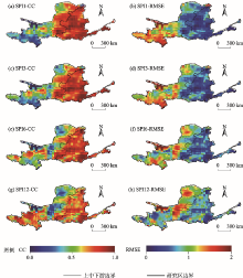
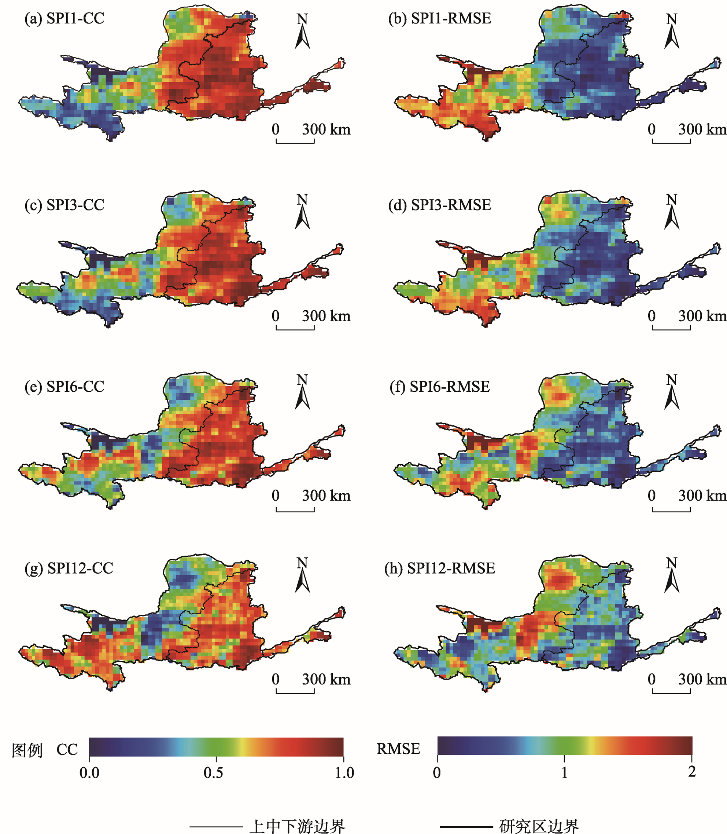
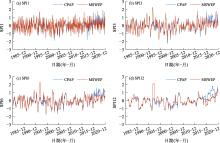
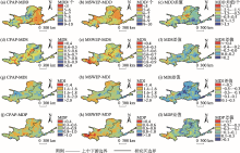
| [1] |
Society A M. Meteorological drought-policy statement[J]. Bulletin of the American Meteorological Society, 1997, 78(5): 847-849.
doi: 10.1175/1520-0477-78.5.847
|
| [2] |
邓梓锋, 吴旭树, 王兆礼, 等. 基于GRACE重力卫星数据的珠江流域干旱监测[J]. 农业工程学报, 2020, 36(20): 179-187.
|
|
[ Deng Zifeng, Wu Xushu, Wang Zhaoli, et al. Drought monitoring based on GRACE data in the Pearl River Basin, China[J]. Transactions of the Chinese Society of Agricultural Engineering, 2020, 36(20): 179-187. ]
|
| [3] |
卫林勇, 江善虎, 任立良, 等. IMERG卫星降水产品在中国的干旱监测效用评估[J]. 农业工程学报, 2021, 37(2): 161-169.
|
|
[ Wei Linyong, Jiang Shanhu, Ren Liliang, et al. Evaluation of drought monitoring in China using IMERG satellite precipitation products[J]. Transactions of the Chinese Society of Agricultural Engineering, 2021, 37(2): 161-169. ]
|
| [4] |
侯英雨, 何延波, 柳钦火, 等. 干旱监测指数研究[J]. 生态学杂志, 2007, 26(6): 892-897.
|
|
[ Hou Yingyu, He Yanbo, Liu Qinhuo, et al. Research progress on drought indices[J]. Chinese Journal of Ecology, 2007, 26(6): 892-897. ]
|
| [5] |
Palmer W C. Meteorological drought[R]. Washington: US Department of Commerce, Weather Bureau, 1965.
|
| [6] |
Mckee T B, Doesken N J, Kleist J. The relationship of drought frequency and duration to time scales[C]// Proceedings of the Eighth Conference on Applied Climatology. Boston: American Meteorological Society, 1993: 179-184.
|
| [7] |
Vicente-serrano S M, Beguería S, López-moreno J. A multiscalar drought index sensitive to global warming: The standardized precipitation evapotranspiration index[J]. Journal of Climate, 2010, 23(7): 1696-1718.
doi: 10.1175/2009JCLI2909.1
|
| [8] |
Alley W M. The Palmer drought severity index: Limitations and assumptions[J]. Journal of Applied Meteorology, 1984, 23: 1100-1109.
|
| [9] |
王林, 陈文. 标准化降水蒸散指数在中国干旱监测的适用性分析[J]. 高原气象, 2014, 33(2): 423-431.
doi: 10.7522/j.issn.1000-0534.2013.00048
|
|
[ Wang Lin, Chen Wen. Applicability analysis of standardized precipitation evapotranspiration index in drought monitoring in China[J]. Plateau Meteorology, 2014, 33(2): 423-431. ]
doi: 10.7522/j.issn.1000-0534.2013.00048
|
| [10] |
李伟光, 陈汇林, 朱乃海, 等. 标准化降水指标在海南岛干旱监测中的应用分析[J]. 中国生态农业学报, 2009, 17(1): 178-182.
doi: 10.3724/SP.J.1011.2009.00178
|
|
[ Li Weiguang, Chen Huilin, Zhu Naihai, et al. Analysis of drought monitoring on Hainan Island from standardized precipitation index[J]. Chinese Journal of Eco-Agriculture, 2009, 17(1): 178-182. ]
doi: 10.3724/SP.J.1011.2009.00178
|
| [11] |
董晓华, 张庆玉, 张特, 等. 三种长期定量降水产品在淮河流域干旱监测中的潜力[J]. 农业工程学报, 2021, 37(11): 93-103.
|
|
[ Dong Xiaohua, Zhang Qingyu, Zhang Te, et al. Potential of three long-term quantitative precipitation products of drought monitoring in Huaihe River Basin[J]. Transactions of the Chinese Society of Agricultural Engineering, 2021, 37(11): 93-103. ]
|
| [12] |
马秋梅. 多源卫星降水产品在长江流域径流模拟中的适用性研究[D]. 武汉: 武汉大学, 2019.
|
|
[ Ma Qiumei. Applicability of multi-source satellite precipitation products in streamflow modeling in the Yangtze River Basin[D]. Wuhan: Wuhan University, 2019. ]
|
| [13] |
Hou A Y, Kakar R K, Neeck S, et al. The global precipitation measurement mission[J]. Bulletin of the American Meteorological Society, 2014, 95(5): 701-722.
doi: 10.1175/BAMS-D-13-00164.1
|
| [14] |
刘元波, 傅巧妮, 宋平, 等. 卫星遥感反演降水研究综述[J]. 地球科学进展, 2011, 26(11): 1162-1172.
|
|
[ Liu Yuanbo, Fu Qiaoni, Song Ping, et al. Satellite retrieval of precipitation: An overview[J]. Advances in Earth Sciences, 2011, 26(11): 1162-1172. ]
|
| [15] |
Huffman G J, Bolvin D T, Nelkin E J, et al. The TRMM multisatellite precipitation analysis (TMPA): Quasi-global, multiyear, combined-sensor precipitation estimates at fine scales[J]. Journal of Hydrometeorology, 2007, 8(1): 38-55.
doi: 10.1175/JHM560.1
|
| [16] |
Joyce R J, Janowiak J E, Arkin P A, et al. CMORPH: A method that produces global precipitation estimates from passive microwave and infrared data at high spatial and temporal resolution[J]. Journal of Hydrometeorology, 2004, 5(3): 487-503.
doi: 10.1175/1525-7541(2004)005<0487:CAMTPG>2.0.CO;2
|
| [17] |
邓越, 蒋卫国, 王晓雅, 等. MSWEP降水产品在中国大陆区域的精度评估[J]. 水科学进展, 2018, 29(4): 455-464.
|
|
[ Deng Yue, Jiang Weiguo, Wang Xiaoya, et al. Accuracy assessment of MSWEP over mainland China[J]. Advances in Water Science, 2018, 29(4): 455-464. ]
|
| [18] |
Beck H E, Wood E F, Pan M, et al. MSWEP V2 global 3-hourly 0.1° precipitation: Methodology and quantitative assessment[J]. Bulletin of the American Meteorological Society, 2019, 100(3): 473-500.
doi: 10.1175/BAMS-D-17-0138.1
|
| [19] |
Xu Z G, Wu Z Y, He H, et al. Evaluating the accuracy of MSWEP V2.1 and its performance for drought monitoring over mainland China[J]. Atmospheric Research, 2019, 226: 17-31.
doi: 10.1016/j.atmosres.2019.04.008
|
| [20] |
Guo H, Li M, Nzabarinda V, et al. Assessment of three long-term satellite-based precipitation estimates against ground observations for drought characterization in northwestern China[J]. Remote Sensing, 2022, 14(4): 828, doi: 10.3390/rs14040828.
doi: 10.3390/rs14040828
|
| [21] |
石琳, 杨春生, 卫林勇, 等. IMERG卫星降水产品实时监测黄河流域干旱效用分析[J]. 水电能源科学, 2021, 39(6): 9-11, 24.
|
|
[ Shi Lin, Yang Chunsheng, Wei Linyong, et al. Utility analysis of IMERG satellite precipitation product for real-time drought monitoring over the Yellow River Basin[J]. Water Resources and Power, 2021, 39(6): 9-11, 24. ]
|
| [22] |
梁守真, 隋学艳, 王猛, 等. 基于SPEI的黄河流域多时间尺度干湿变化分析[J]. 水土保持研究, 2022, 29(1): 231-241.
|
|
[ Liang Shouzhen, Sui Xueyan, Wang Meng, et al. Multiple time scales analysis of dryness and wetness changes of the Yellow River Basin in the past 50 years based on SPEI data[J]. Research of Soil and Water Conservation, 2022, 29(1): 231-241. ]
|
| [23] |
周帅, 王义民, 畅建霞, 等. 黄河流域干旱时空演变的空间格局研究[J]. 水利学报, 2019, 50(10): 1231-1241.
|
|
[ Zhou Shuai, Wang Yimin, Chang Jianxia, et al. Research on spatio-temporal evolution of drought patterns in the Yellow River Basin[J]. Journal of Hydraulic Engineering, 2019, 50(10): 1231-1241. ]
|
| [24] |
曹闯, 任立良, 刘懿, 等. 基于联合干旱指数的黄河流域干旱时空特征[J]. 人民黄河, 2019, 41(5): 51-56.
|
|
[ Cao Chuang, Ren Liliang, Liu Yi, et al. Spatial-temporal characteristics of drought of the Yellow River Basin based on joint drought index[J]. Yellow River, 2019, 41(5): 51-56. ]
|
| [25] |
Zhong R, Chen X, Lai C, et al. Drought monitoring utility of satellite-based precipitation products across mainland China[J]. Journal of Hydrology, 2018, 568: 343-359.
doi: 10.1016/j.jhydrol.2018.10.072
|
| [26] |
GB/T 20481-2017.气象干旱等级[S]. 北京: 中国标准出版社, 2017.
|
|
[[GB/T 20481-2017. Grades of meteorological drought[S]. Beijing: Standards Press of China, 2017.]
|
| [27] |
李斌, 李丽娟, 李海滨, 等. 澜沧江流域干旱变化的时空特征[J]. 农业工程学报, 2011, 27(5): 87-92, 393.
|
|
[ Li Bin, Li Lijuan, Li Haibin, et al. Spatial and temporal variability of droughts in the Lancang River Basin[J]. Transactions of the Chinese Society of Agricultural Engineering, 2011, 27(5): 87-92, 393. ]
|
| [28] |
张世喆, 朱秀芳, 刘婷婷, 等. 基于多维Copula的中国干旱特征及危险性分析[J]. 干旱区地理, 2022, 45(2): 333-345.
|
|
[ Zhang Shizhe, Zhu Xiufang, Liu Tingting, et al. Drought characteristics and risk hazard in China based on multidimensional Copula model[J]. Arid Land Geography, 2022, 45(2): 333-345. ]
|
| [29] |
邱德勋, 穆兴民, 尹殿胜, 等. 大理河流域干旱变化特征及其与极端降水的关系[J]. 干旱区地理, 2021, 44(5): 1240-1249.
|
|
[ Qiu Dexun, Mu Xingmin, Yin Diansheng, et al. Variation characteristics of drought and its relationship with the extreme precipitation in Dali River Basin[J]. Arid Land Geography, 2021, 44(5): 1240-1249. ]
|
| [30] |
王晓峰, 张园, 冯晓明, 等. 基于游程理论和Copula函数的干旱特征分析及应用[J]. 农业工程学报, 2017, 33(10): 206-214.
|
|
[ Wang Xiaofeng, Zhang Yuan, Feng Xiaoming, et al. Analysis and application of drought characteristics based on run theory and Copula function[J]. Transactions of the Chinese Society of Agricultural Engineering, 2017, 33(10): 206-214. ]
|
| [31] |
Guo H, Bao A, Ndayisaba F, et al. Space-time characterization of drought events and their impacts on vegetation in Central Asia[J]. Journal of Hydrology, 2018, 564: 1165-1178.
doi: 10.1016/j.jhydrol.2018.07.081
|
| [32] |
彭振华, 李艳忠, 余文君, 等. 遥感降水产品在中国不同气候区的适用性研究[J]. 地球信息科学学报, 2021, 23(7): 1296-1311.
doi: 10.12082/dqxxkx.2021.200348
|
|
[ Peng Zhenhua, Li Yanzhong, Yu Wenjun, et al. Research on the applicability of remote sensing precipitation products in different climatic regions of China[J]. Journal of Geo-information Science, 2021, 23(7): 1296-1311. ]
doi: 10.12082/dqxxkx.2021.200348
|
 ),朱丽,吕潇雨,郭浩(