- 2025年5月14日 星期三
干旱区地理 ›› 2023, Vol. 46 ›› Issue (5): 689-699.doi: 10.12118/j.issn.1000-6060.2022.425 cstr: 32274.14.ALG2022425
李乐乐1( ),钞锦龙1(),赵德一2,李浩杰1,吴林栋3,李佳骏1
收稿日期:2022-08-29
修回日期:2022-10-07
出版日期:2023-05-25
发布日期:2023-06-05
作者简介:李乐乐(1998-),男,硕士研究生,主要从事区域气候变化和自然灾害方面的研究. E-mail: 基金资助:
LI Lele1(),CHAO Jinlong1(),ZHAO Deyi2,LI Haojie1,WU Lindong3,LI Jiajun1
Received:2022-08-29
Revised:2022-10-07
Published:2023-05-25
Online:2023-06-05
摘要:
利用1957—2019年山西省27个气象站点逐日降水数据,使用小波分析等方法对山西省暴雨时空分布特征进行分析,并基于自然灾害理论使用决策分析法(AHP)进行暴雨灾害风险评估。结果表明:(1) 从时间尺度上看,山西省暴雨发生时间呈现周期性和季节性;暴雨年际变化存在4 a、9 a、14~15 a和27~28 a 4个时间尺度震荡,且震荡周期在缩短,暴雨发生的频次呈增加趋势;暴雨季节分配不均匀,多集中在夏季且形成暴雨灾害的几率较大,每年6—8月期间累积暴雨日数占全年比重高达85.23%,其中7月占比最大,达到45.18%。(2) 从空间尺度上看,暴雨多发生在山西省中南部和海拔较高的山区,整体呈现出由东南向西北递减的规律,地区差异明显;以恒山为界,以南区域强降水发生的概率以及暴雨量普遍要高于北部区域,其中垣曲、五台山、阳城年平均暴雨量在65 mm以上,累积暴雨日数超过60 d。(3) 通过对山西省暴雨灾害风险进行评估,发现山西省暴雨灾害综合风险等级空间上呈现出由南向北逐渐递减的趋势,运城盆地东北部属于高风险区,而山西省东北、西北地区则属于低风险区,其余大部分地区属于中风险区和次高风险区。
李乐乐, 钞锦龙, 赵德一, 李浩杰, 吴林栋, 李佳骏. 1957—2019年山西省暴雨时空分布特征与暴雨灾害风险评估[J]. 干旱区地理, 2023, 46(5): 689-699.
LI Lele, CHAO Jinlong, ZHAO Deyi, LI Haojie, WU Lindong, LI Jiajun. Spatiotemporal distribution characteristics of rainstorm and risk assessment of rainstorm disasters in Shanxi Province from 1957 to 2019[J]. Arid Land Geography, 2023, 46(5): 689-699.
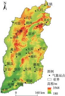
图1
研究区27个气象站点分布"

表1
准则层指标权重判断矩阵及一致性检验"
| 准则层 | 致灾 因子 | 孕灾 环境 | 承灾体 | 防灾减 灾能力 | 权重值 /% |
|---|---|---|---|---|---|
| 致灾因子 | 1 | 4 | 5 | 7 | 58.098 |
| 孕灾环境 | 1/4 | 1 | 3 | 5 | 24.290 |
| 承灾体 | 1/5 | 1/3 | 1 | 3 | 12.011 |
| 防灾减灾能力 | 1/7 | 1/5 | 1/3 | 1 | 5.601 |
| λmax=4.180,CI=0.060,RI=0.890,CR=0.067<0.1 | |||||
表2
致灾因子指标层权重判断矩阵及一致性检验"
| 致灾因子 | 年均 降雨量 | 年均暴 雨日数 | 日最大 降雨量 | 权重值/% |
|---|---|---|---|---|
| 年均降雨量 | 1 | 1/7 | 1/3 | 8.331 |
| 年均暴雨日数 | 7 | 1 | 5 | 72.351 |
| 日最大降雨量 | 3 | 1/5 | 1 | 19.319 |
| λmax=3.066,CI=0.033,RI=0.520,CR=0.063<0.1 | ||||
表3
孕灾环境指标层权重判断矩阵及一致性检验"
| 孕灾环境 | 海拔高程 | 地形坡度 | 河网密度 | 权重值/% |
|---|---|---|---|---|
| 海拔高程 | 1 | 1/2 | 1/3 | 16.378 |
| 地形坡度 | 2 | 1 | 1/2 | 29.726 |
| 河网密度 | 3 | 2 | 1 | 53.896 |
| λmax=3.009,CI=0.005,RI=0.520,CR=0.009<0.1 | ||||
表4
承灾体指标层权重判断矩阵及一致性检验"
| 承灾体 | 人口密度 | 地均GDP | 耕地 面积比 | 权重值/% |
|---|---|---|---|---|
| 人口密度 | 1 | 2 | 3 | 53.896 |
| 地均GDP | 1/2 | 1 | 2 | 29.726 |
| 耕地面积比 | 1/3 | 1/2 | 1 | 16.378 |
| λmax=3.009,CI=0.005,RI=0.520,CR=0.009<0.1 | ||||
表5
防灾减灾能力指标层权重判断矩阵及一致性检验"
| 防灾减灾能力 | 人均GDP | 权重值/% |
|---|---|---|
| 人均GDP | 1 | 100 |
| λmax=0,CI=RI=0 | ||
表 6
暴雨灾害风险评估指标体系"
| 目标层 | 准则层 | 准则层权重值/% | 指标层 | 指标层权重值/% |
|---|---|---|---|---|
| 暴雨灾害风险评估 | 致灾因子 | 58.098 | 年均降雨量/mm | 8.331 |
| 年均暴雨日数/d | 72.351 | |||
| 日最大降雨量/mm | 19.319 | |||
| 孕灾环境 | 24.290 | 海拔高程/m | 16.378 | |
| 地形坡度/(°) | 29.726 | |||
| 河网密度/% | 53.896 | |||
| 承灾体 | 12.011 | 人口密度/人·km-2 | 53.896 | |
| 地均GDP/104元 | 29.726 | |||
| 耕地面积比/% | 16.378 | |||
| 防灾减灾能力 | 5.601 | 人均GDP/元 | 100.000 |
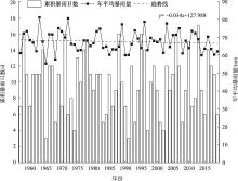
图2
山西省累积暴雨日数、年平均暴雨量年际变化"

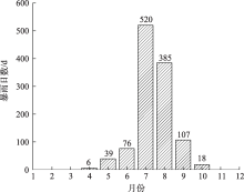
图3
山西省暴雨日数的年内分布"

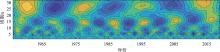
图4
1957—2019年山西省暴雨日数小波变换"


图5
小波方差"
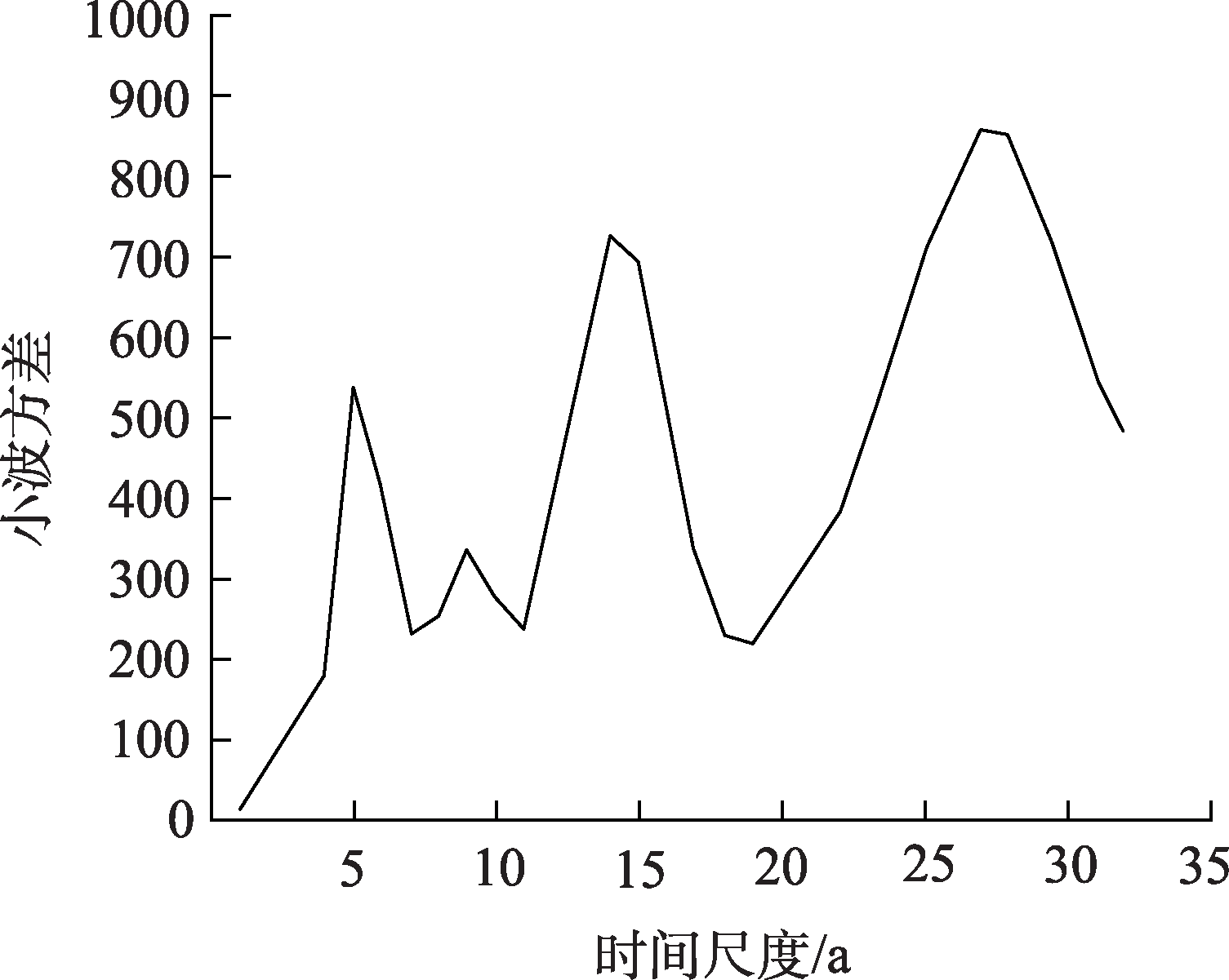
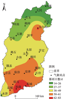
图6
山西省暴雨日数空间分布"
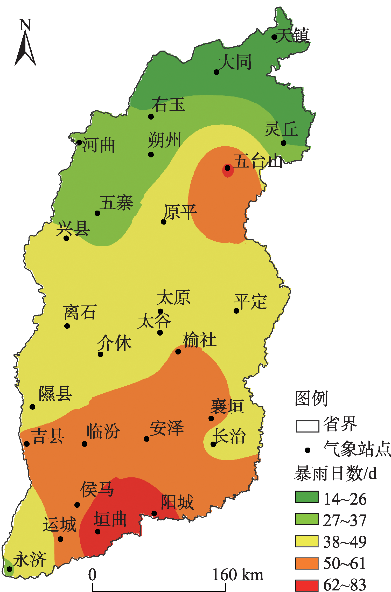

图7
27个气象站点累积暴雨日数和年平均暴雨量"
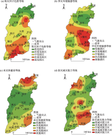
图8
山西省暴雨灾害风险等级划分"

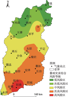
图9
山西省暴雨灾害综合风险等级划分"

| [1] | 黄垭飞, 管兆勇, 蔡倩, 等. 近41年来江南地区暴雨洪涝灾害时空变化特征分析[J]. 气象学报, 2021, 79(4): 582-597. |
| [Huang Yafei, Guan Zhaoyong, Cai Qian, et al. Spatiotemporal variation characteristics of rainstorms and related flood disasters in Jiangnan region in the recent 41 years[J]. Acta Meteorologica Sinica, 2021, 79(4): 582-597. ] | |
| [2] | 陈颖, 马禹. 新疆不同等级暴雨洪涝灾害的时空变化特征[J]. 干旱区地理, 2021, 44(6): 1515-1524. |
| [Chen Ying, Ma Yu. Spatial and temporal characteristics of flood and rainstorm disaster in Xinjiang[J]. Arid Land Geography, 2021, 44(6): 1515-1524. ] | |
| [3] | 冯强, 王昂生, 李吉顺. 我国降水的时空变化与暴雨洪涝灾害[J]. 自然灾害学报, 1998, 7(1): 89-95. |
| [Feng Qiang, Wang Angsheng, Li Jishun. The variation of precipitation in time and space and heavy-rain flood disaster in China[J]. Journal of Natural Disasters, 1998, 7(1): 89-95. ] | |
| [4] | 黄明策. 广西暴雨时空分布特征[J]. 广西气象, 2006, 27(3): 9-13. |
| [Huang Mingce. Rainstorm space and time distributed characteristic in Guangxi[J]. Journal of Guangxi Meteorology, 2006, 27(3): 9-13. ] | |
| [5] | 卢瑞荆, 樊兰峰. 1961—2008年贵州暴雨时空分布特征[J]. 沙漠与绿洲气象, 2010, 4(3): 17-21. |
| [Lu Ruijing, Fan Lanfeng. Spatial and temporal characteristics of rainstorm in Guigzhou during 1961—2008[J]. Desert and Oasis Meteorology, 2010, 4(3): 17-21. ] | |
| [6] | 孔锋. 中国不同月份暴雨的多属性时空演变特征及区域差异(1961—2016年)[J]. 水利水电技术, 2020, 51(2): 26-37. |
| [Kong Feng. Multi-attribute spatio-temporal evolution characteristics and regional differences of heavy rainfall in different months in China from 1961 to 2016[J]. Water Resources and Hydropower Engineering, 2020, 51(2): 26-37. ] | |
| [7] | 侯春梅, 陈忠民, 康雯瑛, 等. 河南汛期暴雨时空分布特征及成因分析[J]. 气象与环境科学, 2008, 31(2): 39-42. |
| [Hou Chunmei, Chen Zhongmin, Kang Wenying, et al. Distribution and cause analysis of the flood season rainstorm in Henan Province[J]. Meteorological and Environmental Sciences, 2008, 31(2): 39-42. ] | |
| [8] |
Brooks H E, Stensrud D J. Climatology of heavy rain events in the United States from hourly precipitation observations[J]. Monthly Weather Review, 2000, 128: 1194-1201.
doi: 10.1175/1520-0493(2000)128<1194:COHREI>2.0.CO;2 |
| [9] | Hail J W, Sayers P B, Dawson R J. Nation-scale assessment of current and future flood risk in England and Wales[J]. Natural Hazards, 2005, 35(1): 147-164. |
| [10] | 丁一汇. 中国暴雨理论的发展历程与重要进展[J]. 暴雨灾害, 2019, 38(5): 395-406. |
| [Ding Yihui. The major advances and development process of the theory of heavy rainfalls in China[J]. Torrential Rain and Disasters, 2019, 38(5): 395-406. ] | |
| [11] | 赵子惜, 陈志和. 基于CMORPH融合降水的中国暴雨时空分布特征分析[J]. 人民珠江, 2020, 41(8): 41-52. |
| [Zhao Zixi, Chen Zhihe. Temporal and spatial distribution characteristics of rainstorm in China based on CMORPH integrated precipitation[J]. Pearl River, 2020, 41(8): 41-52. ] | |
| [12] |
胡畔, 陈波, 史培军. 中国暴雨洪涝灾情时空格局及影响因素[J]. 地理学报, 2021, 76(5): 1148-1162.
doi: 10.11821/dlxb202105008 |
|
[Hu Pan, Chen Bo, Shi Peijun. Spatiotemporal patterns and influencing factors of rainstorm-induced flood disasters in China[J]. Acta Geographica Sinica, 2021, 76(5): 1148-1162. ]
doi: 10.11821/dlxb202105008 |
|
| [13] |
Rahmati O, Zeinivand H, Besharat M. Flood hazard zoning in Yasooj region, Iran, using GIS and multi-criteria decision analysis[J]. Geomatics, Natural Hazards and Risk, 2016, 7(3): 1000-1017.
doi: 10.1080/19475705.2015.1045043 |
| [14] | 裴惠娟, 陈晋, 李雯, 等. 甘肃省暴雨洪水时空分布及风险评估[J]. 自然灾害学报, 2017, 26(3): 167-175. |
| [Pei Huijuan, Chen Jin, Li Wen, et al. Spatiotemporal pattern and risk assessment of storm flood in Gansu Province[J]. Journal of Natural Disasters, 2017, 26(3): 167-175. ] | |
| [15] | 杨幸, 王平, 任宾宾. 基于GIS的汉中市气象灾害风险评估[J]. 江西农业学报, 2019, 31(1): 67-77. |
| [Yang Xing, Wang Ping, Ren Binbin. Risk assessment of meteorological disasters in Hanzhong City based on GIS[J]. Acta Agriculturae Jiangxi, 2019, 31(1): 67-77. ] | |
| [16] | 周月华, 彭涛, 史瑞琴. 我国暴雨洪涝灾害风险评估研究进展[J]. 暴雨灾害, 2019, 38(5): 494-501. |
| [Zhou Yuehua, Peng Tao, Shi Ruiqin. Research progress on risk assessment of heavy rainfall and flood disasters in China[J]. Torrential Rain and Disasters, 2019, 38(5): 494-501. ] | |
| [17] | 孙鹏. 宣城市暴雨分布规律与暴雨洪涝灾害风险评价[D]. 合肥: 合肥工业大学, 2016. |
| [Sun Peng. Evaluation of rainstorm distribution and rainstorm flood disaster risk in Xuancheng City[D]. Heifei: Heifei University of Technology, 2016. ] | |
| [18] | 刘慧, 刘波, 许霞, 等. 基于突变理论的湖南衡阳暴雨灾害风险评估[J]. 灾害学, 2019, 34(3): 221-226. |
| [Liu Hui, Liu Bo, Xu Xia, et al. Risk assessment of rainstorm disaster based on catastrophe in Hengyang of Hunan Province[J]. Journal of Catastrophology, 2019, 34(3): 221-226. ] | |
| [19] | Haruyama S, Ohokura H, Simking T, et al. Geomorphological zoning for flood inundation using satellite data[J]. GeoJournal, 1996, 38(3): 273-278. |
| [20] | 张丽花, 延军平, 陈利民. 近52年山西暴雨气候变化特征分析[J]. 自然灾害学报, 2014, 23(4): 142-148. |
| [Zhang Lihua, Yan Junping, Chen Limin. Characteristic analysis of rainstorm climate change in Shanxi Province during recent 52 years[J]. Journal of Natural Disasters, 2014, 23(4): 142-148. ] | |
| [21] | 袁瑞强, 王亚楠, 王鹏, 等. 降水集中度的变化特征及影响因素分析——以山西为例[J]. 气候变化研究进展, 2018, 14(1): 11-20. |
| [Yuan Ruiqiang, Wang Ya’nan, Wang Peng, et al. An analysis of precipitation concentration variation characteristic and influential factors in Shanxi Province, China[J]. Climate Change Research, 2018, 14(1): 11-20. ] | |
| [22] | 王文娟, 李丽平. 山西省主要气象灾害特征及风险评估——基于暴雨洪涝灾害气象数据融合的实证视角[J]. 科技导报, 2017, 35(8): 81-87. |
| [Wang Wenjuan, Li Liping. Main meteorological disasters and risk assessment in Shanxi Province: Based on empirical analysis of rainstorm and flood disaster data[J]. Science & Technology Review, 2017, 35(8): 81-87. ] | |
| [23] |
赵彩萍, 周晋红, 李兆奇, 等. 城市化对太原暴雨变化的影响[J]. 干旱气象, 2019, 37(1): 109-118.
doi: 10.11755/j.issn.1006-7639(2019)-01-0109 |
|
[Zhao Caiping, Zhou Jinhong, Li Zhaoqi, et al. Influence of urbanization on the change of rainstorm in Taiyuan[J]. Journal of Arid Meteorology, 2019, 37(1): 109-118. ]
doi: 10.11755/j.issn.1006-7639(2019)-01-0109 |
|
| [24] |
苗爱梅, 王洪霞, 武捷. 山西不同历时强降水的统计特征及趋势变化[J]. 高原气象, 2020, 39(4): 796-807.
doi: 10.7522/j.issn.1000-0534.2019.00069 |
|
[Miao Aimei, Wang Hongxia, Wu Jie. Statistical characteristic and trend change of different duration short-duration heavy rainfall in Shanxi Province[J]. Plateau Meteorology, 2020, 39(4): 796-807. ]
doi: 10.7522/j.issn.1000-0534.2019.00069 |
|
| [25] | 山西省统计局. 山西省2019年国民经济与社会发展统计公报[M]. 北京: 中国统计出版社, 2019. |
| [Shanxi Statistical Bureau. Statistical bulletin on national economy and social development of Shanxi Province[M]. Beijing: China Statistics Press, 2019. ] | |
| [26] | 山西省统计局. 山西统计年鉴[M]. 北京: 中国统计出版社, 1957—2019. |
| [Shanxi Statistical Bureau. Shanxi statistical yearbook[M]. Beijing: China Statistics Press, 1957—2019. ] | |
| [27] | 李晓虹, 苏占胜, 纳丽, 等. 贺兰山东麓暴雨气候特征及灾害防御对策[J]. 干旱区地理, 2021, 44(5): 1231-1239. |
| [Li Xiaohong, Su Zhansheng, Na Li, et al. Climate characteristics of rainstorm and disaster prevention countermeasures along eastern Helan Mountain[J]. Arid Land Geography, 2021, 44(5): 1231-1239. ] | |
| [28] | 张应华, 宋献方. 水文气象序列趋势分析与变异诊断的方法及其对比[J]. 干旱区地理, 2015, 38(4): 652-665. |
| [Zhang Yinghua, Song Xianfang. Techniques of abrupt change detection and trends analysis in hydroclimatic time-series: Advance and evaluation[J]. Arid Land Geography, 2015, 38(4): 652-665. ] | |
| [29] | 冯禹昊, 朱江玲. 基于Morlet小波的辽河径流量变化及其成因分析[J]. 水土保持研究, 2019, 26(2): 208-215. |
| [Feng Yuhao, Zhu Jiangling. Analysis on runoff change and the driving force of the Liaohe River Basin based on wavelet Moelet[J]. Research of Soil and Water Conservation, 2019, 26(2): 208-215. ] | |
| [30] | 康丽玮. 陕西秦岭南北地区暴雨时空分布与暴雨灾害风险评估[D]. 西安: 陕西师范大学, 2014. |
| [Kang Liwei. Spatial-temporal distribution of rainstorm and risk assessment of rainstorm disaster in northern and southern Qinling Mountains of Shaanxi Province[D]. Xi’an: Shaanxi Normal University, 2014. ] | |
| [31] | 周轶, 陈柳彤, 黄靖玲, 等. 典型降雨情景下北京市十渡镇山洪灾害风险评估[J]. 灾害学, 2021, 36(3): 97-102. |
| [Zhou Yi, Chen Liutong, Huang Jingling, et al. Flash flood risk assessment in Shidu, Beijing under the typical rainfall scenario[J]. Journal of Catastrophology, 2021, 36(3): 97-102. ] | |
| [32] | 李柔珂, 李耀辉, 徐影. 未来中国地区的暴雨洪涝灾害风险预估[J]. 干旱气象, 2018, 36(3): 341-352. |
| [Li Rouke, Li Yaohui, Xu Ying. Projection of rainstorm and flooding disaster in China in the 21stcentury[J]. Journal of Arid Meteorology, 2018, 36(3): 341-352. ] | |
| [33] | 刘荆, 蒋卫国, 杜培军, 等. 基于相关分析的淮河流域暴雨灾害风险评估[J]. 中国矿业大学学报, 2009, 38(5): 735-740. |
| [Liu Jing, Jiang Weiguo, Du Peijun, et al. Rainstorm risk assessment of Huaihe River based on correlation analysis[J]. Journal of China University of Mining & Technology, 2009, 38(5): 735-740. ] | |
| [34] | 王林旺. 山西省暴雨成因及时空分布研究[J]. 中国水利, 2003, 54(12): 74-75. |
| [Wang Linwang. Study on causes and spatial and temporal distribution of rainstorm in Shanxi Province[J]. China Water Resources, 2003, 54(12): 74-75. ] | |
| [35] | 魏海茹, 刘婉莉. 运城市突发气象灾害区域分析[J]. 科技情报开发与经济, 2007, 17(18): 168-169. |
| [Wei Hairu, Liu Wanli. Analysis on the burst weather disaster areas in Yuncheng City[J]. Journal of Library and Information Science, 2007, 17(18): 168-169. ] | |
| [36] | 孔锋, 方建, 吕丽莉, 等. 中国长短历时暴雨时空变化格局及其对总暴雨贡献的研究(1951—2010)[J]. 中国人口·资源与环境, 2016, 26(增刊2): 316-320. |
| [Kong Fei, Fang Jian, Lü Lili, et al. Long and short duration heavy rainfall spatio-temporal patterns change and its contribution to total heavy rainfall in China (1951—2010)[J]. China Population, Resources and Environment, 2016, 26(Suppl. 2): 316-320. ] |
| [1] | 古丽扎尔·莫明, 杨莲梅, 刘艳, 李新国. 伊犁河流域近30 a洪水灾害时空分布及孕灾环境特征研究[J]. 干旱区地理, 2024, 47(8): 1314-1326. |
| [2] | 张连成, 司嘉怡, 胡列群, 王梅霞, 张太西. 基于两种降水数据的苏巴什水库暴雨山洪淹没模拟及致灾临界雨量阈值研究[J]. 干旱区地理, 2024, 47(7): 1147-1155. |
| [3] | 王岱, 崔洋, 王素艳, 张雯. 1961—2020年宁夏干旱事件年代际变化及风险评估[J]. 干旱区地理, 2024, 47(5): 785-797. |
| [4] | 蔡霞, 梁桂花, 张冬峰, 蔡琳, 白樱, 李锐锋. 山西北部极端降水时空演变规律及与大气环流因子的响应[J]. 干旱区地理, 2024, 47(3): 391-402. |
| [5] | 李晓萌, 杨莲梅, 李建刚, 刘晶. 昆仑山北坡“6·14”极端暴雨过程的中尺度对流系统特征分析[J]. 干旱区地理, 2024, 47(10): 1700-1712. |
| [6] | 王冠孝,王伟,张娟娟. 乡村旅游与农村人居环境的耦合协调关系及障碍因子诊断——以山西省为例[J]. 干旱区地理, 2024, 47(1): 170-180. |
| [7] | 张静, 保广裕, 刘玮, 杨春华, 燕振宁, 代青措, 傅永超. 青海公路沿线暴雨洪涝灾害风险指数特征与模型研究[J]. 干旱区地理, 2024, 47(1): 28-37. |
| [8] | 黄鑫, 焦黎, 马晓飞, 王勇辉, 阿尔曼·阿布拉. 基于RClimDex模型的近60 a中亚极端降水事件变化特征[J]. 干旱区地理, 2023, 46(7): 1039-1051. |
| [9] | 刘耀龙,何冰晶,张华明,王军. 基于混合损失超越曲线的省域气象灾害农业风险评估[J]. 干旱区地理, 2023, 46(5): 711-718. |
| [10] | 李娜,武永利,赵桂香,钱锦霞,李芬,赵海英,韩普. 近60 a山西省极端气温事件的年际变化及其对区域增暖的响应[J]. 干旱区地理, 2023, 46(3): 337-348. |
| [11] | 吴志祥, 张志斌, 赵学伟, 陈龙, 马晓敏, 柴姣. 中国西北地区A级旅游景区时空分布格局及影响因素[J]. 干旱区地理, 2023, 46(12): 2061-2073. |
| [12] | 魏娟娟, 万瑜, 张俊兰, 赵凤环, 李桉孛. 近20 a塔城地区暖区暴雪环流分型及成因分析[J]. 干旱区地理, 2022, 45(6): 1718-1728. |
| [13] | 刘兆旭,刘晶,范子昂. 2005—2020年新疆雷电灾害特征分析[J]. 干旱区地理, 2022, 45(5): 1402-1414. |
| [14] | 买合木提江·维吉旦,玉素甫江·如素力,仇忠丽. 2000—2019年新疆积雪终日时空变化特征[J]. 干旱区地理, 2022, 45(4): 1061-1070. |
| [15] | 杜军,高佳佳,王挺,平措桑旦. 2007—2020年西藏草面温度时空分布特征[J]. 干旱区地理, 2022, 45(4): 1103-1113. |
| Viewed | ||||||||||||||||||||||||||||||||||||||||||||||||||
|
Full text 321
|
|
|||||||||||||||||||||||||||||||||||||||||||||||||
|
Abstract 481
|
|
|||||||||||||||||||||||||||||||||||||||||||||||||
Cited |
|
|||||||||||||||||||||||||||||||||||||||||||||||||
| Shared | ||||||||||||||||||||||||||||||||||||||||||||||||||
|
||