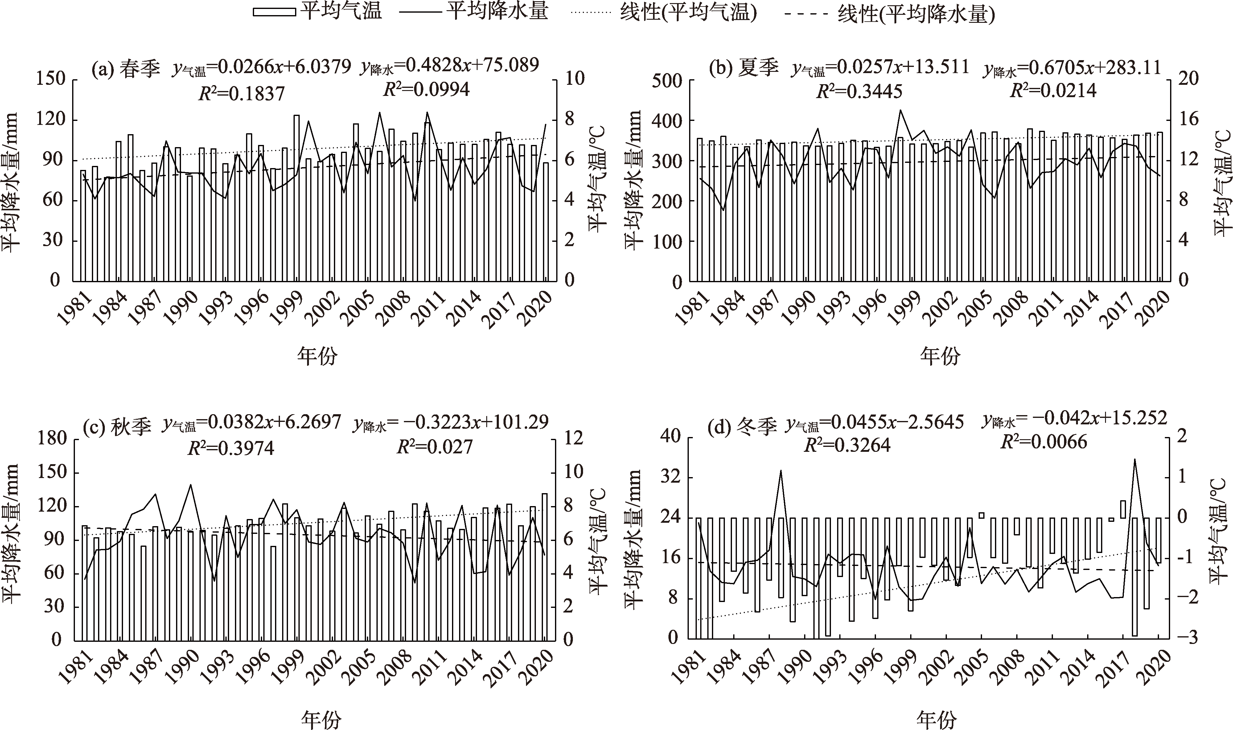
| [1] |
姜大膀, 王晓欣. 对IPCC第六次评估报告中有关干旱变化的解读[J]. 大气科学学报, 2021, 44(5): 650-653.
|
|
[Jiang Dabang, Wang Xiaoxin. A brief interpretation of drought change from IPCC Sixth Assessment Report[J]. Transactions of Atmospheric Sciences, 2021, 44(5): 650-653.]
|
| [2] |
王晓利, 张春艳, 侯西勇. 1961—2017年环渤海地区气象干旱时空特征及致灾危险性评估[J]. 生态学报, 2019, 39(13): 4647-4659.
|
|
[Wang Xiaoli, Zhang Chunyan, Hou Xiyong. Spatial-temporal characteristics and hazard risks of meteorological drought in Circum-Bohai-Sea region from 1961 to 2017[J]. Acta Ecologica Sinica, 2019, 39(13): 4647-4659.]
|
| [3] |
Freitas A A, Drumond A, Carvalho V S B, et al. Drought assessment in São Francisco River Basin, Brazil: Characterization through SPI and associated anomalous climate patterns[J]. Atmosphere, 2022, 13(1): 41, doi: 10.3390/atmos13010041.
doi: 10.3390/atmos13010041
|
| [4] |
Yang B, Kong L, Lai C G, et al. A framework on analyzing long-term drought changes and its influential factors based on the PDSI[J]. Atmosphere, 2022, 13(7): 1151, doi: 103390/atmos13071151.
doi: 103390/atmos13071151
|
| [5] |
Suroso, Nadhilah D, Ardiansyah, et al. Drought detection in Java Island based on standardized precipitation and evapotranspiration index (SPEI)[J]. Journal of Water and Climate Change, 2021, 12(6): 2734-2752.
doi: 10.2166/wcc.2021.022
|
| [6] |
费龙, 邓国荣, 张洪岩, 等. 基于降水Z指数的朝鲜降水及旱涝时空特征[J]. 自然资源学报, 2020, 35(12): 3051-3063.
doi: 10.31497/zrzyxb.20201219
|
|
[Fei Long, Deng Guorong, Zhang Hongyan, et al. Spatiotemporal patterns of precipitation and drought and flood using Z-index in Democratic People’s Republic of Korea[J]. Journal of Natural Resources, 2020, 35(12): 3051-3063.]
doi: 10.31497/zrzyxb.20201219
|
| [7] |
周丽, 谢舒蕾, 吴彬. 基于CI和强度分析方法的四川冬春季干旱事件变化特征[J]. 自然灾害学报, 2020, 29(3): 36-44.
|
|
[Zhou Li, Xie Shulei, Wu Bin. Variation characteristics of the winter and spring drought events in Sichuan based on CI and intensity analysis[J]. Journal of Natural Disasters, 2020, 29(3): 36-44.]
|
| [8] |
曲学斌, 杨钦宇, 王慧清, 等. 基于MCI的内蒙古气象干旱强度特征分析[J]. 气象与环境科学, 2019, 42(4): 47-54.
|
|
[Qu Xuebin, Yang Qinyu, Wang Huiqing, et al. Characteristics of meteorological drought intensity in Inner Mongolia based on MCI[J]. Meteorological and Environmental Sciences, 2019, 42(4): 47-54.]
|
| [9] |
熊俊楠, 刘志奇, 范春捆, 等. 1983—2013年西藏自治区气象灾害时空分布特征与变化趋势[J]. 冰川冻土, 2017, 39(6) : 1221-1231.
|
|
[Xiong Junnan, Liu Zhiqi, Fan Chunkun, et al. Temporal and spatial distribution characteristics and changing trend of meteorologic disaster in Tibet Autonomous Region from 1983 through 2013[J]. Journal of Glaciology and Geocryology, 2017, 39(6): 1221-1231.]
|
| [10] |
史继清, 豆永丽, 杨霏云, 等. 西藏地区潜在蒸散量时空格局特征及影响因素研究[J]. 干旱区研究, 2021, 38(3): 724-732.
|
|
[Shi Jiqing, Dou Yongli, Yang Feiyun, et al. Temporal and spatial pattern characteristics of potential evapotranspiration in Tibet and its influencing factors[J]. Arid Zone Research, 2021, 38(3): 724-732.]
|
| [11] |
史继清, 杨霏云, 边多, 等. 基于干旱灾害风险综合评估指数的西藏主要农区青稞干旱时空格局[J]. 中国农学通报, 2021, 37(2): 80-87.
doi: 10.11924/j.issn.1000-6850.casb20200200107
|
|
[Shi Jiqing, Yang Feiyun, Bian Duo, et al. Temporal and spatial patterns of barley in Tibet major agricultural areas based on the comprehensive assessment index of drought disaster risk[J]. Chinese Agricultural Science Bulletin, 2021, 37(2): 80-87.]
doi: 10.11924/j.issn.1000-6850.casb20200200107
|
| [12] |
高佳佳, 徐薇, 边央, 等. 基于FAO Penman-Monteith方法的西藏春青稞干旱趋势研究[J]. 中国农学通报, 2021, 37(11): 79-86.
doi: 10.11924/j.issn.1000-6850.casb2020-0124
|
|
[Gao Jiajia, Xu Wei, Bian Yang, et al. The drought tendency of spring highland barley on Tibet Plateau: A research via the FAO Penman-Monteith method[J]. Chinese Agricultural Science Bulletin, 2021, 37(11): 79-86.]
doi: 10.11924/j.issn.1000-6850.casb2020-0124
|
| [13] |
宋善允, 王鹏祥. 西藏气候[M]. 北京: 气象出版社, 2013: 11-13, 385-387.
|
|
[Song Shanyun, Wang Pengxiang. Tibet climate[M]. Beijing: China Meteorology Press, 2013: 11-13, 385-387.]
|
| [14] |
蒙强, 刘静霞, 李玉庆, 等. 土壤水分下限调控灌溉对春青稞生长、产量和水分利用的影响[J]. 干旱地区农业研究, 2020, 38(1): 173-182.
|
|
[Meng Qiang, Liu Jingxia, Li Yuqing, et al. Effects of regulated irrigation of lower limits of soil moisture on growth, yield and water use efficiency of spring highland barley[J]. Agricultural Research in the Arid Areas, 2020, 38(1): 173-182.]
|
| [15] |
时学双, 李法虎, 闫宝莹, 等. 不同生育期水分亏缺对春青稞水分利用和产量的影响[J]. 农业机械学报, 2015, 46(10): 144-151, 265.
|
|
[Shi Xueshuang, Li Fahu, Yan Baoying, et al. Effects of water deficit at different growth stages on water use and yield of spring highland barley[J]. Journal of Agricultural Machinery, 2015, 46(10): 144-151, 265.]
|
| [16] |
郑盐源. 日土县气象灾害对青稞种植的影响及其防御对策[J]. 现代农业科技, 2017(23): 172-176.
|
|
[Zheng Yanyuan. Effects of meteorological disasters on highland barley cultivation in Rutog County and its countermeasures[J]. Modern Agricultural Science and Technology, 2017(23): 172-176.]
|
| [17] |
邓国卫, 孙俊, 赖江, 等. 四川水稻不同生育期干旱与产量灰色关联分析[J]. 干旱气象, 2022, 40(5): 814-822.
doi: 10.11755/j.issn.1006-7639(2022)-05-0814
|
|
[Deng Guowei, Sun Jun, Lai Jiang, et al. Grey correlation analysis of drought and yield at different growth stages of rice in Sichuan Province[J]. Journal of Arid Meteorology, 2022, 40(5): 814-822.]
doi: 10.11755/j.issn.1006-7639(2022)-05-0814
|
| [18] |
黄岩, 李晶, 王莹, 等. 不同生育期干旱对玉米生长及产量的影响模拟[J]. 农业灾害研究, 2019, 9(6): 47-49, 92.
|
|
[Huang Yan, Li Jing, Wang Ying, et al. Impact simulation of drought on maize growth and yield in different growth stages[J]. Study on Agricultural Disaster, 2019, 9(6): 47-49, 92.]
|
| [19] |
曹永强, 王怡涵, 冯兴兴, 等. 河北省夏玉米不同生育期干旱时空分析[J]. 华北水利水电大学学报(自然科学版), 2020, 41(4): 1-9.
|
|
[Cao Yongqiang, Wang Yihan, Feng Xingxing, et al. Spatio-temporal analysis of drought in different growth stages of summer maize in Hebei Province[J]. Journal of North China University of Water Resources and Electric Power (Natural Science Edition), 2020, 41(4): 1-9.]
|
| [20] |
吴乾慧. 1960—2015年北方冬麦区冬小麦生育期农业干旱演变特征及风险区划[D]. 兰州: 西北师范大学, 2018.
|
|
[Wu Qianhui. Agricultural drought evolution and risk regionalization of winter wheat in north China during growth period from 1960 to 2015[D]. Lanzhou: Northwest Normal University, 2018.]
|
| [21] |
金建新, 张娜, 桂林国. 西藏地区干旱指标的时空演变[J]. 水土保持研究, 2019, 26(5): 377-380.
|
|
[Jin Jianxin, Zhang Na, Gui Linguo. Temporal and spatial variations of the drought index to the Tibetan Plateau[J]. Research of Soil and Water Conservation, 2019, 26(5): 377-380.]
|
| [22] |
袁雷, 刘依兰, 马鹏飞. 基于标准化降水指数的1981—2013年西藏干旱时空特征分析[J]. 中国农学通报, 2015, 31(25): 228-234.
doi: 10.11924/j.issn.1000-6850.casb15040033
|
|
[Yuan Lei, Liu Yilan, Ma Pengfei. Temporal and spatial patterns of drought based on standard precipitation index (SPI) in Tibet during 1981—2013[J]. Chinese Agricultural Science Bulletin, 2015, 31(25): 228-234.]
doi: 10.11924/j.issn.1000-6850.casb15040033
|
| [23] |
孙晓光, 王腾, 李白萍, 等. 基于标准化降水指数的西藏昌都市旱涝时空特征[J]. 中国农学通报, 2017, 33(8): 112-118.
doi: 10.11924/j.issn.1000-6850.casb16050076
|
|
[Sun Xiaoguang, Wang Teng, Li Baiping, et al. Spatial and temporal characteristics of drought-flood in Chamdo based on standard precipitation index (SPI)[J]. Chinese Agricultural Science Bulletin, 2017, 33(8): 112-118.]
doi: 10.11924/j.issn.1000-6850.casb16050076
|
| [24] |
王圆圆, 扎西央宗. 利用条件植被指数评价西藏植被对气象干旱的响应[J]. 应用气象学报, 2016, 27(4): 435-444.
|
|
[Wang Yuanyuan, Zhaxi Yangzong. Assessing vegetation response to meteorological drought in Tibet Autonomous Region using vegetation index[J]. Journal of Applied Meteorological Science, 2016, 27(4): 435-444.]
|
| [25] |
杜军, 袁雷, 周刊社, 等. 西藏自治区县级青稞种植气候适宜性区划[M]. 北京: 气象出版社, 2017.
|
|
[Du Jun, Yuan Lei, Zhou Kanshe, et al. Climate suitability zoning for highland barley cultivation at County Tibet[M]. Beijing: China Meteorology Press, 2017.]
|
| [26] |
张强, 邹旭恺, 肖风劲, 等. 气象干旱等级[M]. 北京: 气象出版社, 2008: 33-53.
|
|
[Zhang Qiang, Zou Xukai, Xiao Fengjin, et al. Meteorological drought grade[M]. Beijing: China Meteorology Press, 2008: 33-53.]
|
| [27] |
Jung J. Spatial analysis of the vulnerability to meteorological hazards in Korea[J]. Journal of Climate Research, 2018, 13(3): 211-229.
doi: 10.14383/cri.
|
| [28] |
史继清, 边多, 杨霏云, 等. 西藏地区潜在蒸散量变化特征及灰色模型预测初探[J]. 干旱区地理, 2021, 44(6): 1570-1579.
|
|
[Shi Jiqing, Bian Duo, Yang Feiyun, et al. Variation characteristics of potential evapotranspiration and the forecast of grey model in Tibet[J]. Arid Land Geography, 2021, 44(6): 1570-1579.]
|
| [29] |
赵峰, 毕硕本, 李兴宇, 等. 基于EOF和REOF的1470—1911年黄河中下游地区旱涝空间分布特征分析[J]. 干旱区地理, 2019, 42(4): 799-809.
|
|
[Zhao Feng, Bi Shuoben, Li Xingyu, et al. Spatial characteristics of drought/flood disasters based on EOF and REOF in the middle and lower reaches of the Yellow River from 1470 to 1911[J]. Arid Land Geography, 2019, 42(4): 799-809.]
|
 ),甘臣龙2(