干旱区地理 ›› 2021, Vol. 44 ›› Issue (6): 1796-1809.doi: 10.12118/j.issn.1000–6060.2021.06.27
赵力1,2( ),张炜3,刘楠2,周典1(),孙培峰2
收稿日期:2021-03-18
修回日期:2021-08-16
出版日期:2021-11-25
发布日期:2021-12-03
通讯作者:
周典
作者简介:赵力(1993-),男,工程师,博士研究生,主要从事自然保护地规划、监测、评估等理论和实践研究. E-mail: 基金资助:
ZHAO Li1,2(),ZHANG Wei3,LIU Nan2,ZHOU Dian1(),SUN Peifeng2
Received:2021-03-18
Revised:2021-08-16
Online:2021-11-25
Published:2021-12-03
Contact:
Dian ZHOU
摘要:
青海湖与祁连山毗邻区域生态旅游资源保护与保护性利用,已成为青海省以国家公园为主体的自然保护地体系示范省建设的重要组成部分。选取青海湖与祁连山毗邻区域为研究对象,在实际调查的基础上,依据国家公园理念下的资源特性,采用ArcGIS空间叠加分析、德尔菲法、AHP(Analytic hierarchy process)层次分析法,对区域内生态旅游资源进行梳理与分类评价。经评价定级,区域内生态旅游资源级别分为5级,游憩资源单体特品级即五级1处;优良级30处,其中四级8处、三级22处;普通级48处,其中二级32处、一级16处。研究表明:在国家公园理念下,生态旅游资源评价指标体系要素层权重前三名依次是旅游功能和价值、人文特色、生态环境,评价层选取了国家公园资源属性的因子。可以看出,国家公园首要功能原真性和完整性指标因子是评价指标因子选取的关键点。旨在为拟建青海湖国家公园功能区划定提供数据支撑,为国土空间禁止开发区域的生态旅游资源评价提供方法,其研究视角和路径对国家公园理念下游憩资源深度保护和利用具有借鉴作用。
赵力,张炜,刘楠,周典,孙培峰. 国家公园理念下区域生态旅游资源评价——以青海湖与祁连山毗邻区域为例[J]. 干旱区地理, 2021, 44(6): 1796-1809.
ZHAO Li,ZHANG Wei,LIU Nan,ZHOU Dian,SUN Peifeng. Evaluation of regional ecotourism resources under the concept of National Park: Taking the adjacent area between the Qinghai Lake and the Qilian Mountains as an example[J]. Arid Land Geography, 2021, 44(6): 1796-1809.

图1
青海湖与祁连山毗邻区域范围"
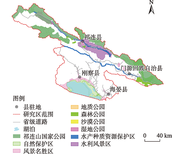
图2
青海湖与祁连山毗邻区域生态旅游资源分布"
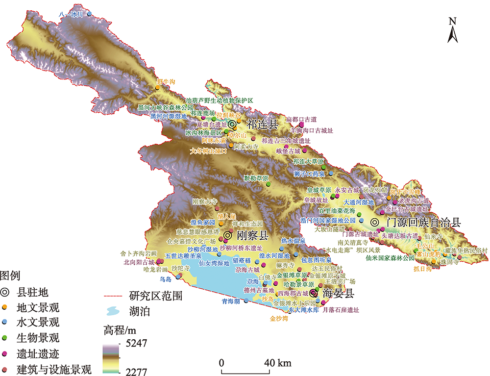
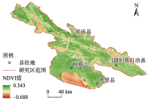
图3
青海湖与祁连山毗邻区域植被NDVI指数分布"

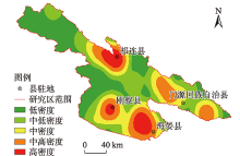
图4
青海湖与祁连山毗邻区域自然资源核密度分析"


图5
青海湖与祁连山毗邻区域景点核密度分析"
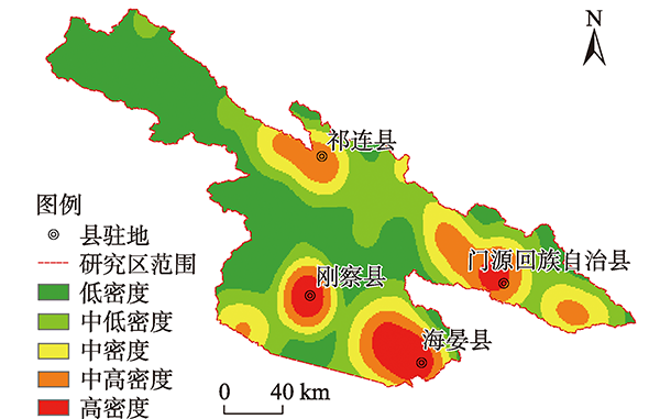
表1
青海湖与祁连山毗邻区域生态旅游资源评价指标"
| 目标层(A) | 制约层(B) | 要素层(C) | 评价层(D) | 评价方式或参数 |
|---|---|---|---|---|
| 生态旅游资源综合评价(A) | 物质文化资源质量(B1) | 人文特色(C1) | 历史文化价值(D1) 景点知名度(D2) 保护力度(D3) | 年代特征 专家问卷 专家问卷 |
| 旅游功能和价值(C2) | 生态资源完整度(D4) 生态资源独特性(D5) 生态资源多样性(D6) 生态资源科学度(D7) 生态资源利用度(D8) | 专家问卷 专家问卷 专家问卷 专家问卷 专家问卷 | ||
| 资源种类分布(C3) | 规模化程度(D9) 组合条件(D10) 聚集度(D11) | 规模指数 多样性指数 聚合度指数 | ||
| 环境特征(B2) | 生态环境(C4) | 环境完整性(D12) 环境适宜度(D13) 生态安全保障水平(D14) | 生态干扰度 大气/地面水/土壤质量 专家问卷 | |
| 科研教育(C5) | 讲解设施完整性(D15) 环境教育活动(D16) | 分布密度 次·a-1 | ||
| 健康(C6) | 步行适宜性(D17) 自然体验(D18) | 步道长度 专家问卷 | ||
| 社会、经济条件(C7) | 旅游区安全性(D19) 基础配套设施完整性(D20) 旅游设施完整性(D21) 地理位置(D22) | 地质灾害分布/数量 设施分布密度 设施类型多样性 专家问卷 | ||
| 开发条件(B3) | 区域位置条件(C8) | 生态旅游资源面积(D23) 交通可达性(D24) 周边旅游区相互影响情况(D25) 旅游适宜期(D26) | km2 路网密度 专家问卷 月·a-1 | |
| 客流来源(C9) | 客流量(D27) 游客消费水平(D28) | 人·a-1 元·a-1 |
表2
判断矩阵标度及对照表"
| 标度 | 含义 |
|---|---|
| 1 | 因子n与m同样重要 |
| 3 | 因子n比m稍微重要 |
| 5 | 因子n比m明显重要 |
| 7 | 因子n比m重要得多 |
| 9 | 因子n比m极端重要 |
| 2、4、6、8 | 因子n比m重要程度分别介 于1~3、3~5、5~7、7~9之间 |
| | 因子m比n的不重要程度 |
表3
随机一致性指标对照表RI值"
| q | 1 | 2 | 3 | 4 | 5 | 6 | 7 | 8 | 9 |
|---|---|---|---|---|---|---|---|---|---|
| RI | 0.00 | 0.00 | 0.58 | 0.90 | 1.12 | 1.24 | 1.32 | 1.41 | 1.45 |
表4
生态旅游资源评价分值标准"
| 评价指标 | 评价依据 | 1~2分 | 3~4分 | 5~6分 | 7~8分 | 9~10分 |
|---|---|---|---|---|---|---|
| 历史文化价值(D1) | 历史久远性 | 清朝之后 | 元清之间 | 宋元之间 | 唐宋之间 | 唐代之前 |
| 景点知名度(D2) | 知名程度 | 较低 | 一般 | 中等 | 较高 | 非常高 |
| 保护力度(D3) | 保护措施完善度 | 较低 | 一般 | 中等 | 较高 | 非常高 |
| 生态资源完整度(D4) | 生态资源完整程度 | <30% | 30%~50% | 50%~70% | 70%~90% | >90% |
| 生态资源独特性(D5) | 生态资源典型性 | 较低 | 一般 | 中等 | 较高 | 非常高 |
| 生态资源多样性(D6) | 生态资源类型数量 | <4类 | 4~6类 | 6~8类 | 8~10类 | >10类 |
| 生态资源科学度(D7) | 生态资源科普教育价值 | <50种 | 100种左右 | 200~300种 | 300~500种 | >500种 |
| 生态资源利用度(D8) | 生态资源可利用 程度 | 较低 | 一般 | 中等 | 较高 | 非常高 |
| 规模化程度(D9) | 规模指数 | 低 | 一般 | 中等 | 很大 | 非常大 |
| 组合条件(D10) | 多样性指数 | 不合适 | 较合适 | 合适 | 很合适 | 非常合适 |
| 聚集度(D11) | 聚合度指数 | 差 | 一般 | 好 | 很好 | 非常集中 |
| 环境完整性(D12) | 生态干扰度指数 | 非常高 | 较高 | 中等 | 一般 | 较低 |
| 环境适宜度(D13) | 大气/地面水/土壤质量 | 差 | 一般 | 较好 | 好 | 整体很高 |
| 生态安全保障水平(D14) | 生态污染情况 | 较严重 | 有污染 | 轻微污染 | 不影响 | 无污染 |
| 讲解设施完整性(D15) | 讲解设施分布密度 | 较低 | 一般 | 中等 | 较高 | 非常高 |
| 环境教育活动(D16) | 环境教育活动数量 /次·a-1 | <5 | 5~10 | 10~15 | 15~20 | >20 |
| 步行适宜性(D17) | 步道网络密度 /m·hm-2 | <50 | 50~100 | 100~150 | 150~200 | >200 |
| 自然体验(D18) | 自然体验状况 | 差 | 一般 | 中等 | 好 | 非常好 |
| 旅游区安全性(D19) | 自然地质灾害状况 | 易发 | 偶发 | 中等 | 较少 | 稀少 |
| 基础配套设施完整性(D20) | 基础设施分布密度 | 较低 | 一般 | 中等 | 较高 | 非常高 |
| 旅游设施完整性(D21) | 旅游设施数量和 类型 | 较低 | 一般 | 中等 | 较高 | 非常高 |
| 地理位置(D22) | 与城中心的距离 | 脱离区域 城市中心 | >500 km,距离远 | 250~500 km,处 于路边线上 | 100~250 km, 处于节点位置 | <100 km,位 于中心地区 |
| 生态旅游资源面积(D23) | 游人可进入面积 /km2 | <1 | 1~5 | 5~10 | 10~50 | >50 |
| 交通可达性(D24) | 景区周边交通路网密度/km·km-2 | <0.1 | 0.1~0.5 | 0.5~1.0 | 1.0~5.0 | >5.0 |
| 周边旅游区相互影响情况(D25) | 与附近旅游异同 | 相似度高 | 相似度较高 | 互为补充 | 相似度较低 | 相似度低 |
| 旅游适宜期(D26) | 年适宜旅游月份数量/月·a-1 | <1 | 1~2 | 2~4 | 4~10 | >10 |
| 客流量(D27) | 年客流量/人次·a-1 | <1×10⁴ | 1×10⁴~5×10⁴ | 5×10⁴~20×104 | 20×104~50×104 | >50×104 |
| 游客消费水平(D28) | 年游客消费水平 /元·a-1 | <100×104 | 100×104~500×104 | 500×104~ 2000×104 | 2000×104~ 5000×104 | >5000×104 |
表5
生态旅游资源权重指标分配"
| 目标层(A) | 制约层(B) | 权重 | 要素层(C) | 权重 | 评价层(D) | 权重 | 排序 |
|---|---|---|---|---|---|---|---|
| 生态旅游资源综合评价(A) | 物质文化资源质量(B1) | 0.612 | 人文特色(C1) | 0.198 | 历史文化价值(D1) | 0.085 | 1 |
| 景点知名度(D2) | 0.071 | 5 | |||||
| 保护力度(D3) | 0.042 | 8 | |||||
| 旅游功能和价值(C2) | 0.213 | 生态资源完整度(D4) | 0.072 | 4 | |||
| 生态资源独特性(D5) | 0.078 | 3 | |||||
| 生态资源多样性(D6) | 0.022 | 19 | |||||
| 生态资源科学度(D7) | 0.020 | 23 | |||||
| 生态资源利用度(D8) | 0.021 | 20 | |||||
| 资源种类分布(C3) | 0.085 | 规模化程度(D9) | 0.026 | 15 | |||
| 组合条件(D10) | 0.030 | 13 | |||||
| 聚集度(D11) | 0.029 | 14 | |||||
| 环境特征(B2) | 0.251 | 生态环境(C4) | 0.170 | 环境完整性(D12) | 0.081 | 2 | |
| 环境适宜度(D13) | 0.057 | 6 | |||||
| 生态安全保障水平(D14) | 0.032 | 10 | |||||
| 科研教育(C5) | 0.073 | 讲解设施完整性(D15) | 0.026 | 16 | |||
| 环境教育活动(D16) | 0.047 | 7 | |||||
| 健康(C6) | 0.063 | 步行适宜性(D17) | 0.032 | 11 | |||
| 自然体验(D18) | 0.031 | 12 | |||||
| 社会、经济条件(C7) | 0.071 | 旅游区安全性(D19) | 0.021 | 21 | |||
| 基础配套设施完整性(D20) | 0.016 | 25 | |||||
| 旅游设施完整性(D21) | 0.021 | 22 | |||||
| 地理位置(D22) | 0.013 | 27 | |||||
| 开发条件(B3) | 0.137 | 区域位置条件(C8) | 0.089 | 生态旅游资源面积(D23) | 0.020 | 24 | |
| 交通可达性(D24) | 0.010 | 28 | |||||
| 周边旅游区相互影响情况(D25) | 0.033 | 9 | |||||
| 旅游适宜期(D26) | 0.026 | 17 | |||||
| 客流来源(C9) | 0.038 | 客流量(D27) | 0.024 | 18 | |||
| 游客消费水平(D28) | 0.014 | 26 |
表6
生态旅游资源评价结果"
| 主类 | 亚类 | 基本类型 | 旅游资源名称 | 旅游资源位置 | 综合 得分 | 排名 | 级别 |
|---|---|---|---|---|---|---|---|
| 地文景观 | 自然景观综合体 | 山丘型景观 | 岗什卡雪峰 | 门源 | 6.824 | 8 | 四级 |
| 雾山虎豹 | 门源 | 6.018 | 30 | 三级 | |||
| 毛公山 | 门源 | 5.112 | 56 | 二级 | |||
| 卓尔山 | 祁连 | 7.149 | 3 | 四级 | |||
| 阿咪东索 | 祁连 | 6.845 | 7 | 四级 | |||
| 沟谷型景观 | 拉洞峡谷 | 门源 | 5.663 | 42 | 二级 | ||
| 抓日沟 | 门源 | 5.904 | 32 | 三级 | |||
| 野牛沟 | 祁连 | 4.108 | 71 | 一级 | |||
| 大冬树山垭口 | 祁连 | 6.309 | 21 | 三级 | |||
| 滩地型景观 | 沙岛 | 海晏 | 6.629 | 14 | 三级 | ||
| 金沙湾 | 海晏 | 6.749 | 9 | 四级 | |||
| 地表形态 | 台丘状地景 | 情人崖 | 刚察 | 6.742 | 11 | 三级 | |
| 沟壑与洞穴 | 格萨乐王藏剑洞 | 门源 | 6.451 | 19 | 三级 | ||
| 水域景观 | 河系 | 游憩河段 | 沙柳河湿地 | 刚察 | 5.429 | 47 | 二级 |
| 浩门河国家湿地公园 | 门源 | 5.329 | 50 | 二级 | |||
| 大通河湿地 | 祁连 | 5.372 | 49 | 二级 | |||
| 黑河河源湿地 | 祁连 | 5.696 | 40 | 二级 | |||
| 湟水河湿地 | 祁连 | 5.864 | 34 | 二级 | |||
| 湖沼 | 游憩湖区 | 青海湖(海北片) | 海晏 | 9.424 | 1 | 五级 | |
| 东大滩水库 | 海晏 | 5.860 | 35 | 二级 | |||
| 错褡裢 | 海晏 | 4.572 | 65 | 一级 | |||
| 尕海 | 海晏 | 6.545 | 17 | 三级 | |||
| 湿地 | 鸟岛 | 刚察 | 6.543 | 18 | 三级 | ||
| 湟鱼家园 | 刚察 | 6.056 | 27 | 三级 | |||
| 仙女湾湿地 | 刚察 | 6.998 | 4 | 四级 | |||
| 包忽图听泉 | 门源 | 4.469 | 66 | 一级 | |||
| 热水温泉 | 海晏 | 4.786 | 62 | 二级 | |||
| 五世达赖圣泉 | 刚察 | 5.321 | 51 | 二级 | |||
| 狮子口药泉 | 门源 | 5.161 | 54 | 二级 | |||
| 冰雪地 | 现代冰川 | 八一冰川 | 祁连 | 5.641 | 43 | 二级 | |
| 生物景观 | 植被景观 | 林地 | 仙米国家森林公园 | 门源 | 6.621 | 16 | 三级 |
| 黑河大峡谷森林公园 | 祁连 | 6.625 | 15 | 三级 | |||
| 冰沟林海景区 | 祁连 | 6.852 | 6 | 四级 | |||
| 草地 | 金银滩草原 | 海晏 | 6.712 | 12 | 三级 | ||
| 哈勒景草原 | 海晏 | 5.420 | 48 | 二级 | |||
| 皇城草原 | 门源 | 5.695 | 41 | 二级 | |||
| 祁连大草原 | 祁连 | 6.689 | 13 | 三级 | |||
| 默勒草原 | 祁连 | 5.800 | 37 | 二级 | |||
| 祁连鹿场 | 祁连 | 6.067 | 25 | 三级 | |||
| 百里油菜花海 | 门源 | 7.325 | 2 | 四级 | |||
| 野生动物栖息地 | 陆地动物栖息地 | 油葫芦野生动植物保护区 | 祁连 | 5.524 | 44 | 二级 | |
| 主类 | 亚类 | 基本类型 | 旅游资源名称 | 旅游资源位置 | 综合 得分 | 排名 | 级别 |
| 建筑与设施 | 人文景观综合体 | 社会与商贸活动场所 | 达玉民俗村 | 海晏 | 6.145 | 23 | 三级 |
| 藏族华热民俗村 | 门源 | 5.849 | 36 | 二级 | |||
| 建设工程与生产地 | 金银滩原子城 | 海晏 | 6.926 | 5 | 四级 | ||
| 文化活动场所 | 祥和生态园 | 刚察 | 5.722 | 39 | 二级 | ||
| 康体游乐休闲度假地 | 金银滩水上乐园 | 海晏 | 5.886 | 33 | 二级 | ||
| 宗教与祭祀活动场所 | 刚察大寺 | 刚察 | 6.748 | 10 | 三级 | ||
| 沙陀寺 | 刚察 | 4.865 | 61 | 二级 | |||
| 白佛寺 | 海晏 | 4.440 | 67 | 一级 | |||
| 嘛秀寺 | 海晏 | 3.964 | 75 | 一级 | |||
| 阿柔大寺 | 门源 | 6.425 | 20 | 三级 | |||
| 仙米寺 | 门源 | 5.937 | 31 | 三级 | |||
| 南关清真寺 | 门源 | 3.651 | 77 | 一级 | |||
| 珠固寺 | 门源 | 4.062 | 73 | 一级 | |||
| 纪念地与纪念活动 场所 | 仓央嘉措文化广场 | 刚察 | 6.135 | 24 | 三级 | ||
| 王洛宾广场 | 海晏 | 6.058 | 26 | 三级 | |||
| 实用建筑与核心设施 | 桥梁隧道 | 大坂山隧道 | 门源 | 4.339 | 69 | 一级 | |
| 堤坝段落 | “水电走廊”坝区 | 门源 | 4.727 | 63 | 二级 | ||
| 景观与小品建筑 | 书画作 | 舍卜齐沟岩画 | 海晏 | 5.129 | 55 | 二级 | |
| 哈龙岩画 | 刚察 | 5.029 | 57 | 二级 | |||
| 雕塑 | 岗龙石窟 | 门源 | 4.653 | 64 | 一级 | ||
| 塔形建筑 | 慈悲慧眼感恩塔 | 刚察 | 6.147 | 22 | 三级 | ||
| 遗址遗迹 | 物质类文化遗存 | 建筑遗迹 | 西海郡古城 | 海晏 | 6.036 | 28 | 三级 |
| 尕海古城 | 海晏 | 5.187 | 53 | 二级 | |||
| 金巴台古城遗址 | 门源 | 4.090 | 72 | 一级 | |||
| 门源古城遗址 | 门源 | 5.522 | 45 | 二级 | |||
| 皇城故址 | 门源 | 6.027 | 29 | 三级 | |||
| 永安古城 | 门源 | 4.364 | 68 | 一级 | |||
| 北向阳古城 | 刚察 | 5.010 | 59 | 二级 | |||
| 羊胸沟口古城 | 祁连 | 2.663 | 79 | 一级 | |||
| 峨堡古城 | 祁连 | 5.187 | 52 | 二级 | |||
| 祁连古三角城遗址 | 祁连 | 3.682 | 76 | 一级 | |||
| 古道遗址 | 扁都口古道 | 祁连 | 4.212 | 70 | 一级 | ||
| 头塘达坂古道 | 门源 | 3.981 | 74 | 一级 | |||
| 老虎沟古道 | 门源 | 3.601 | 78 | 一级 | |||
| 文化遗存 | 月落石崖遗址 | 海晏 | 5.745 | 38 | 二级 | ||
| 夏塘台遗址 | 祁连 | 5.018 | 58 | 二级 | |||
| 德州古墓地 | 海晏 | 4.950 | 60 | 二级 | |||
| 沙柳河桥东遗址 | 刚察 | 5.513 | 46 | 二级 |
表7
生态旅游资源评价级别"
| 生态旅游资源级别 | 数量 | 生态旅游资源名称 |
|---|---|---|
| 五级 | 1 | 青海湖(海北州片区) |
| 四级 | 8 | 百里油菜花海、卓尔山、阿咪东索、仙女湾湿地、金银滩原子城、冰沟林海景区、岗什卡雪峰、金沙湾 |
| 三级 | 23 | 情人崖、金银滩草原、沙岛、黑河大峡谷森林公园、仙米国家森林公园、尕海、鸟岛、格萨乐王藏剑洞、阿柔大寺、大冬树山垭口、慈悲慧眼感恩塔、达玉民俗村、仓央嘉措文化广场、祁连鹿场、王洛宾广场、湟鱼家园、西海郡古城、皇城故址、雾山虎豹、仙米寺、抓日沟、刚察大寺、祁连大草原 |
| 二级 | 31 | 东大滩水库、藏族华热民俗村、默勒草原、月落石崖遗址、祥和生态园、黑河河源湿地、皇城草原、拉洞峡谷、八一冰川、油葫芦野生动植物保护区、门源古城遗址、沙柳河桥东遗址、沙柳河湿地、哈勒景草原、大通河湿地、浩门河国家湿地公园、五世达赖圣泉、峨堡古城、尕海古城、狮子口药泉、舍卜齐沟岩画、毛公山、哈龙岩画、夏塘台遗址、北向阳古城、德州古墓地、沙陀寺、热水温泉、“水电走廊”坝区、金银滩水上乐园、湟水河湿地 |
| 一级 | 16 | 岗龙石窟、错褡裢、包忽图听泉、白佛寺、永安古城、大坂山隧道、扁都口古道、野牛沟、金巴台古城遗址、珠固寺、头塘达坂古道、嘛秀寺、祁连古三角城遗址、南关清真寺、老虎沟古道、羊胸沟口古城 |
| [1] | GB/T 18972-2017. 旅游资源分类、调查与评价[S]. 北京: 中国标准出版社出版, 2017. |
| [GB/T 18972-2017. Classification, investigation and evaluation of tourism resources[S]. Beijing: Standards Press of China, 2017. ] | |
| [2] | LY/T 3189-2020. 国家公园资源调查与评价规范[S]. 北京: 中国标准出版社出版, 2020. |
| [LY/T 3189-2020. Regulation of resources surveying and evaluating in national park[S]. Beijing: Standards Press of China, 2020. ] | |
| [3] | 张海霞, 张旭亮. 自然遗产地国家公园模式发展的影响因素与空间扩散[J]. 自然资源学报, 2012, 27(4):705-712. |
| [ Zhang Haixia, Zhang Xuliang. Driving factors and spatial diffusion for the development of national park model for natural heritage sites[J]. Journal of Natural Resources, 2012, 27(4):705-712. ] | |
| [4] |
Lunney D, Pressey B, Archer M, et al. Integrating ecology and economics: Illustrating the need to resolve the conflicts of space and time[J]. Ecological Economics, 1997, 23(2):135-143.
doi: 10.1016/S0921-8009(97)00049-9 |
| [5] | 周睿, 钟林生, 刘家明, 等. 中国国家公园体系构建方法研究——以自然保护区为例[J]. 资源科学, 2016, 38(4):577-587. |
| [ Zhou Rui, Zhong Linsheng, Liu Jiaming, et al. Establishing a national park category system in China[J]. Resources Science, 2016, 38(4):577-587. ] | |
| [6] | 张书颖, 刘家明, 朱鹤, 等. 国外生态旅游研究进展及启示[J]. 地理科学进展, 2018, 37(9):45-59. |
| [ Zhang Shuying, Liu Jiaming, Zhu He, et al. Review of progress in international research on ecotourism and implications[J]. Progress in Geography, 2018, 37(9):45-59. ] | |
| [7] | 国家旅游局人事劳动教育司. 旅游规划原理[M]. 北京: 旅游教育出版社, 1999: 1-32. |
| [Department of Personnel and Labor Education, National Tourism Administration. Tourism planning principles[M]. Beijing: Tourism Education Press, 1999: 1-32. ] | |
| [8] | 李春良. 深入贯彻落实习近平生态文明思想建立具有中国特色的自然保护地体系[J]. 旗帜, 2019, 3(8):37-38. |
| [ Li Chunliang. Establishing a system of natural protected areas with Chinese characteristic on Xi Jinping’s ecological civilization thought[J]. Qizhi, 2019, 3(8):37-38. ] | |
| [9] | 中共中央办公厅, 国务院办公厅. 关于建立以国家公园为主体的自然保护地体系的指导意见[EB/OL]. http://www.gov.cn/xinwen/2019-07/03/content_5405621.html . |
| [General Office of the CPC Central Committee, General Office of the State Council. Guiding opinions on establishing a system of natural protected areas with national parks as the main body[EB/OL]. http://www.gov.cn/xinwen/2019-07/03/content_5405621.html .] | |
| [10] | 梅燕. 自然保护区旅游地学资源保护性开发研究[M]. 北京: 科学出版社, 2016: 1-15. |
| [ Mei Yan. Study of the protection and exploitation of tourism geoscience resources in nature reserves[M]. Beijing: Science Press, 2016: 1-15. ] | |
| [11] |
Gössling Stefan. Ecotourism: A means to safeguard biodiversity and ecosystem functions?[J]. Ecological Economics, 1999, 29(2):303-320.
doi: 10.1016/S0921-8009(99)00012-9 |
| [12] |
Lee Choong-Ki. Measuring the economic value of ecotourism resources: The case of south Korea[J]. Journal of Travel Research, 1998, 36(4):40-46.
doi: 10.1177/004728759803600405 |
| [13] | Machado Kleber Bladimir. Willingness to pay for conservation programs: A contingent valuation study of the Galapagos National Park[D]. Ithaca: The University of Cornell, 2000: 3-4. |
| [14] | 王建军, 李朝阳, 田明中. 生态旅游资源分类与评价体系构建[J]. 地理研究, 2006, 25(3):507-516. |
| [ Wang Jianjun, Li Chaoyang, Tian Mingzhong. The establishment of the classification and evaluation system of ecotourism resource[J]. Geographical Research, 2006, 25(3):507-516. ] | |
| [15] | 周文丽. 生态旅游资源综合评价指标体系及评价模型研究[J]. 西北林学院学报, 2007, 22(3):198-202. |
| [ Zhou Wenli. A study on comprehensive assessment of eco-tourism resources system and appraisal model[J]. Journal of Northwest Forestry University, 2007, 22(3):198-202. ] | |
| [16] | 曾涛, 邸雪颖, 杨光, 等. 湖泊湿地生态旅游资源评价——以兴凯湖国家级自然保护区为例[J]. 东北林业大学学报, 2010, 38(5):110-113. |
| [ Zeng Tao, Di Xueying, Yang Guang, et al. Evaluation on eco-tourism resources in lake wetlands: A case study in Xingkai Lake National Nature Reserve[J]. Journal of Northeast Forestry University, 2010, 38(5):110-113. ] | |
| [17] | 马国强, 周杰珑, 丁东, 等. 国家公园生态旅游野生动植物资源评价指标体系初步研究[J]. 林业调查规划, 2011, 36(4):109-114. |
| [ Ma Guoqiang, Zhou Jielong, Ding Dong, et al. Wildlife resources evaluation system for national park ecological tourism[J]. Forest Inventory and Planning, 2011, 36(4):109-114. ] | |
| [18] | 于泉洲, 梁春玲, 刘煜杰, 等. 基于MODIS的山东省植被覆盖时空变化及其原因分析[J]. 生态环境学报, 2015, 24(11):1799-1807. |
| [ Yu Quanzhou, Liang Chunling, Liu Yujie, et al. Analysis of vegetation spatio-temporal variation and driving factors in Shandong Province based on MODIS[J]. Ecology and Environmental Sciences, 2015, 24(11):1799-1807. ] | |
| [19] | 曹乐, 聂振龙, 刘敏, 等. 民勤绿洲天然植被生长与地下水埋深变化关系[J]. 水文地质工程地质, 2020, 47(3):25-33. |
| [ Cao Le, Nie Zhenlong, Liu Min, et al. Changes in natural vegetation growth and groundwater depth and their relationship in the Minqin oasis in the Shiyang River Basin[J]. Hydrogeology & Engineering Geology, 2020, 47(3):25-33. ] | |
| [20] |
徐芝英, 胡云锋, 甄霖, 等. 基于小波的浙江省NDVI与自然-人文因子多尺度空间关联分析[J]. 地理研究, 2015, 34(3):567-577.
doi: 10.11821/dlyj201503014 |
|
[ Xu Zhiying, Hu Yunfeng, Zhen Lin, et al. Wavelet-based multi-scale analysis of NDVI and background factors in Zhejiang Province[J]. Geographical Research, 2015, 34(3):567-577. ]
doi: 10.11821/dlyj201503014 |
|
| [21] | 王春燕, 昝梅, 施国芳, 等. 新疆文化资源空间分布特征及成因分析——以非物质文化遗产为例[J]. 干旱区地理, 2021, 44(2):584-593. |
| [ Wang Chunyan, Zan Mei, Shi Guofang, et al. Spatial distribution and cause of cultural resources in Xinjiang: Taking intangible cultural heritage as an example[J]. Arid Land Geography, 2021, 44(2):584-593. ] | |
| [22] | 刘俊, 李云云, 林楚, 等. 长江旅游带旅游资源空间格局研究[J]. 长江流域资源与环境, 2016, 25(7):1009-1015. |
| [ Liu Jun, Li Yunyun, Lin Chu, et al. Spatial pattern of the tourism resources of Yangtze River tourism belt[J]. Resources and Environment in the Yangtze Basin, 2016, 25(7):1009-1015. ] | |
| [23] | 王章郡, 方忠权, 杜坤. 旅游资源密度的概念及其应用——以从化市旅游资源为例[J]. 干旱区地理, 2011, 34(6):990-995. |
| [ Wang Zhangjun, Fang Zhongquan, Du Kun. Concept and application of tourism resource density: A case of tourism resource of Conghua City[J]. Arid Land Geography, 2011, 34(6):990-995. ] | |
| [24] | 保继刚, 楚义芳. 旅游地理学[M]. 三版. 北京: 高等教育出版社, 2012: 98-102. |
| [ Bao Jigang, Chu Yifang. Geography of tourism[M]. 3rd ed. Beijing: Higher Education Press, 2012: 98-102. ] | |
| [25] | 汪殿蓓, 李建华, 杨清平, 等. 双峰山国家森林公园生态旅游资源评价[J]. 林业科学研究, 2009, 22(4):613-617. |
| [ Wang Dianpei, Li Jianhua, Yang Qingping, et al. Evaluationon on the eco-tourism resources of mountain Shuangfeng National Forest Park[J]. Forest Research, 2009, 22(4):613-617. ] | |
| [26] |
程静静, 胡善风, 张圆刚, 等. 基于粗糙集和层次分析法的农村居民旅游目的地选择研究[J]. 地理科学, 2016, 36(12):1885-1893.
doi: 10.13249/j.cnki.sgs.2016.12.014 |
|
[ Cheng Jingjing, Hu Shanfeng, Zhang Yuangang, et al. Tourism destination of rural residents based on rough set and analytic hierarchy process method[J]. Scientia Geographica Sinica, 2016, 36(12):1885-1893. ]
doi: 10.13249/j.cnki.sgs.2016.12.014 |
|
| [27] | 张博雅, 陈美兰, 刘东, 等. 百花山国家级自然保护区生态旅游资源评价[J]. 东北林业大学学报, 2016, 44(7):70-75. |
| [ Zhang Boya, Chen Meilan, Liu Dong, et al. Comprehensive evaluation of the ecotourism resources at Baihua Mountain National Nature Reserve[J]. Journal of Northeast Forestry University, 2016, 44(7):70-75. ] | |
| [28] | 于洪贤, 宋红娟. 三江自然保护区乡村旅游资源评价[J]. 东北林业大学学报, 2007, 35(3):82-85. |
| [ Yu Hongxian, Song Hongjuan. Evaluation of rural tourism resources in Sanjiang Nature Reserve[J]. Journal of Northeast Forestry University, 2007, 35(3):82-85. ] | |
| [29] | 马倩倩, 董博, 许旺旺, 等. 干旱区耕地质量等级评价及土壤养分与盐渍化的分析研究——以民勤绿洲为例[J]. 干旱区地理, 2021, 44(2):514-524. |
| [ Ma Qianqian, Dong Bo, Xu Wangwang, et al. Evaluation of cultivated land quality and analysis of soil nutrients and salinization in arid areas: Taking Minqin oasis as an example[J]. Arid Land Geography, 2021, 44(2):514-524. ] | |
| [30] | 吴文婕, 韩鹤, 赵艳梅, 等. 新疆公共服务资源空间配置与城乡互动耦合协调发展评价[J]. 干旱区地理, 2020, 43(4):1117-1126. |
| [ Wu Wenjie, Han He, Zhao Yanmei, et al. Coupling coordination evaluation on public service resource spatial allocation and the urban-rural interaction development in Xinjiang[J]. Arid Land Geography, 2020, 43(4):1117-1126. ] | |
| [31] | 保继刚. 旅游资源定量评价初探[J]. 干旱区地理, 1988, 11(3):60-63. |
| [ Bao Jigang. A preliminary study on the quantitative evaluation of the tourist resource[J]. Arid Land Geography, 1988, 11(3):60-63. ] | |
| [32] |
丛小丽, 黄悦, 刘继生. 吉林省生态旅游与旅游环境耦合协调度的时空演化研究[J]. 地理科学, 2019, 39(3):496-505.
doi: 10.13249/j.cnki.sgs.2019.03.016 |
|
[ Cong Xiaoli, Huang Yue, Liu Jisheng. Spatial and temporal evolution of coupled coordination degree of ecotourism and tourism environment of Jilin Province[J]. Arid Land Geography, 2019, 39(3):496-505. ]
doi: 10.13249/j.cnki.sgs.2019.03.016 |
|
| [33] | 骆世明, 彭少麟. 农业生态系统分析[M]. 广州: 广东科技出版社, 1996: 597-601. |
| [ Luo Shiming, Pen Shaolin. Agroecosystem analysis[M]. Guangzhou: Guangdong Science and Technology Press, 1996: 597-601. ] | |
| [34] | 骆正清, 杨善林. 层次分析法中几种标度的比较[J]. 系统工程理论与实践, 2004, 24(9):51-60. |
| [ Luo Zhengqing, Yang Shanlin. Comparative study on several scales in AHP[J]. Systems Engineering-Theory & Practice, 2004, 24(9):51-60. ] | |
| [35] | 李艳玲, 吴建伟, 朱烨行. 基于判断矩阵一致性程度的专家权重确定方法[J]. 计算机与现代化, 2017, 33(6):20-29. |
| [ Li Yanling, Wu Jianwei, Zhu Yehang. A method for determining expert’s weight based on consistency of judgment matrix[J]. Computer and Modernization, 2017, 33(6):20-29. ] | |
| [36] | 彭立圣, 牟瑞芳. 层次分析法在生态旅游资源评价中的应用研究[J]. 环境科学与管理, 2006, 6(3):177-180. |
| [ Peng Lisheng, Mou Ruifang. Application research into the analytic hierarchy pricess on ecological tourism resource assessment[J]. Environmental Science and Management, 2006, 6(3):177-180. ] | |
| [37] | 袁书琪. 试论生态旅游资源的特征、类型和评价体系[J]. 生态学杂志, 2004, 23(2):109-113. |
| [ Yuan Shuqi. On the characteristic, type and evaluatin system of ecological tourism resource[J]. Chinese Journal of Ecology, 2004, 23(2):109-113. ] | |
| [38] | 刘成武, 黄利民. 资源科学概论[M]. 第二版. 北京: 科学出版社, 2014: 69-70. |
| [ Liu Chengwu, Huang Limin. Introduction to resource science[M]. 2nd ed. Beijing: Science Press, 2014: 69-70. ] |
| [1] | 荣丽华, 李伊彤. 国土空间规划背景下畜牧业生产适宜性评价与分区——以锡林郭勒盟镶黄旗为例[J]. 干旱区地理, 2023, 46(7): 1166-1175. |
| [2] | 罗镕基, 王宏涛, 王成. 基于改进遥感生态指数的甘肃省古浪县生态质量评价[J]. 干旱区地理, 2023, 46(4): 539-549. |
| [3] | 邹亚锋, 张倩, 饶钰飞, 邓敏, 王淇. 中国西部省会城市新型城镇化发展水平演化研究[J]. 干旱区地理, 2023, 46(4): 636-648. |
| [4] | 许昕彤,朱丽,吕潇雨,郭浩. MSWEP降水产品在黄河流域气象干旱监测中的适用性评价[J]. 干旱区地理, 2023, 46(3): 371-384. |
| [5] | 肖东升,王宁,刘志成. 干旱地区“代表性人口格网数据集”精度研究——以甘宁青地区为例[J]. 干旱区地理, 2023, 46(3): 505-514. |
| [6] | 张帅, 原伟杰, 刘卉, 王海霞, 官昊慧, 王鹿振. 附面层位移厚度对沙障防风效益评价的适用性研究——以聚乳酸(PLA)沙障为例[J]. 干旱区地理, 2023, 46(12): 1973-1983. |
| [7] | 陈谢扬, 李同昇, 朱小青, 徐博, 朱炳臣, 李炬霖. 基于实际调查与观测解译对比验证的土地沙漠化敏感性评价——以陕西省为例[J]. 干旱区地理, 2023, 46(11): 1813-1825. |
| [8] | 蒋磊, 刘小龙, 郭帅, 何亮, 邢建磊, 郭俊杰. 基于Logistic回归分析的土壤盐渍化易发性评价——以新疆南疆塔里木灌区为例[J]. 干旱区地理, 2023, 46(11): 1858-1867. |
| [9] | 张晓东,赵志鹏,赵银鑫,高学花,马玉学,刘乃静,吉卫波. 银川市景观生态风险评价与生态安全格局优化构建[J]. 干旱区地理, 2022, 45(5): 1626-1636. |
| [10] | 金令,王永芳,郭恩亮,刘桂香,包玉龙. 基于SPEIbase v.2.6数据集的内蒙古旱灾危险性评价[J]. 干旱区地理, 2022, 45(3): 695-705. |
| [11] | 郭小芹,李光明,孙占峰,王兴涛. 祁连山及周边降水分布聚类检验和典型流域增雨效果评价[J]. 干旱区地理, 2022, 45(3): 706-714. |
| [12] | 范斌,丁宏伟,张霖鑫,张凌鹏,张永军. 兰州新区浅层地温能赋存条件及土壤源热泵系统适宜性分析[J]. 干旱区地理, 2022, 45(3): 836-846. |
| [13] | 罗新兰,孙悦,刘利民,王立为,杨丽桃,高西宁. 华北一作区马铃薯生长发育及产量对干旱胁迫响应的模拟研究——以武川县为例[J]. 干旱区地理, 2022, 45(3): 867-878. |
| [14] | 陈晨,汪丽,程林. 北方农牧交错带少数民族语地名文化脆弱性评价体系构建与实证[J]. 干旱区地理, 2022, 45(3): 976-985. |
| [15] | 龙小翠,刘京,徐仲炜,尉芳. 陕西渭北旱塬区县域耕地时空变化及其对粮食生产影响[J]. 干旱区地理, 2022, 45(2): 423-434. |
|
||