- 2025年5月15日 星期四
干旱区地理 ›› 2022, Vol. 45 ›› Issue (5): 1626-1636.doi: 10.12118/j.issn.1000-6060.2022.021 cstr: 32274.14.ALG2022021
张晓东1( ),赵志鹏1,赵银鑫1,高学花2,马玉学1,刘乃静1,吉卫波1
收稿日期:2022-01-14
修回日期:2022-04-02
出版日期:2022-09-25
发布日期:2022-10-20
作者简介:张晓东(1980-),男,博士,高级工程师,主要从事环境遥感应用研究. E-mail: 基金资助:
ZHANG Xiaodong1(),ZHAO Zhipeng1,ZHAO Yinxin1,GAO Xuehua2,MA Yuxue1,LIU Naijing1,JI Weibo1
Received:2022-01-14
Revised:2022-04-02
Published:2022-09-25
Online:2022-10-20
摘要:
银川市生态保护与高质量发展已成为黄河流域可持续发展的重要组成部分,亟需优化区域生态安全格局。以银川市为研究区,综合生态风险评价模型和最小累积阻力模型,分析了银川市景观生态风险的时空分异特征,构建了生态安全格局并提出了生态安全保护策略。结果表明:(1) 银川市景观生态风险整体呈中北部高、南部低的空间分布特征,2000、2010年和2020年的景观生态风险指数平均值分别为0.2155、0.2145和0.2130,生态风险整体呈下降趋势,生态风险等级总体由高等级向低等级转移。(2) 共识别优化银川市生态廊道22条,生态节点52个,生态廊道累计长度约511.23 km,大致呈“北西—东南”方向网状分布,北部稀疏、南部密集。6条关键廊道贯穿南北,沿贺兰山国家级自然保护区—黄河—白芨滩国家级自然保护区一带分布,形成了“三纵”的空间格局分布特征。(3) 银川市优化后的生态安全格局由819.56 km2的生态源地、22条生态廊道和52个生态节点构成,并提出了针对生态源地、廊道和节点的生态安全保护策略,以期为银川市景观生态风险评价和生态安全水平的提升提供理论参考和依据。
张晓东,赵志鹏,赵银鑫,高学花,马玉学,刘乃静,吉卫波. 银川市景观生态风险评价与生态安全格局优化构建[J]. 干旱区地理, 2022, 45(5): 1626-1636.
ZHANG Xiaodong,ZHAO Zhipeng,ZHAO Yinxin,GAO Xuehua,MA Yuxue,LIU Naijing,JI Weibo. Landscape ecological risk assessment and ecological security pattern optimization construction in Yinchuan City[J]. Arid Land Geography, 2022, 45(5): 1626-1636.
表1
研究区数据源"
| 数据类型 | 数据来源 | 数据说明 |
|---|---|---|
| 土地利用数据 | 中国科学院资源环境科学数据中心 | 空间分辨率为30 m,其土地利用一级类型综合评价精度可达到90%以上[ |
| Landsat 8遥感影像 | 地理空间数据云 | 获取植被覆盖度,构造阻力面 |
| 数字高程模型(DEM) | 地理空间数据云 | 构建阻力面 |
| 社会经济数据 | 银川市统计年鉴与《全国重要生态系统保护和修复重大工程总体规划(2021—2035)》[ | 参考资料 |

图1
研究区生态风险小区划分"

表2
2000、2010年和2020年各景观类型景观指数统计"
| 土地利用类型 | 年份 | NP | Ci | Ni | Ki | Si | Fi | Ri |
|---|---|---|---|---|---|---|---|---|
| 耕地 | 2000 | 216 | 0.0009 | 0.0255 | 0.1819 | 0.0445 | 0.1905 | 0.0085 |
| 2010 | 205 | 0.0009 | 0.0266 | 0.1704 | 0.0425 | 0.1905 | 0.0081 | |
| 2020 | 192 | 0.0009 | 0.0257 | 0.1682 | 0.0418 | 0.1905 | 0.0080 | |
| 林地 | 2000 | 267 | 0.0058 | 0.1488 | 0.0803 | 0.0636 | 0.1429 | 0.0091 |
| 2010 | 277 | 0.0055 | 0.1388 | 0.0847 | 0.0614 | 0.1429 | 0.0088 | |
| 2020 | 285 | 0.0060 | 0.1484 | 0.0849 | 0.0645 | 0.1429 | 0.0092 | |
| 草地 | 2000 | 445 | 0.0019 | 0.0381 | 0.2228 | 0.0569 | 0.0952 | 0.0054 |
| 2010 | 471 | 0.0020 | 0.0392 | 0.2279 | 0.0584 | 0.0952 | 0.0056 | |
| 2020 | 555 | 0.0025 | 0.0449 | 0.2380 | 0.0623 | 0.0952 | 0.0059 | |
| 水域 | 2000 | 397 | 0.0149 | 0.3114 | 0.0955 | 0.1200 | 0.2381 | 0.0286 |
| 2010 | 451 | 0.0160 | 0.3147 | 0.1073 | 0.1239 | 0.2381 | 0.0295 | |
| 2020 | 437 | 0.0156 | 0.3115 | 0.1044 | 0.1221 | 0.2381 | 0.0291 | |
| 建设用地 | 2000 | 1270 | 0.0549 | 0.6421 | 0.2698 | 0.2741 | 0.0476 | 0.0130 |
| 2010 | 1200 | 0.0295 | 0.3548 | 0.2658 | 0.1743 | 0.0476 | 0.0083 | |
| 2020 | 1241 | 0.0184 | 0.2180 | 0.2894 | 0.1325 | 0.0476 | 0.0063 | |
| 未利用土地 | 2000 | 376 | 0.0029 | 0.0631 | 0.1497 | 0.0503 | 0.2857 | 0.0144 |
| 2010 | 436 | 0.0036 | 0.0719 | 0.1578 | 0.0549 | 0.2857 | 0.0157 | |
| 2020 | 447 | 0.0041 | 0.0812 | 0.1528 | 0.0570 | 0.2857 | 0.0163 |
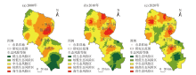
图2
2000、2010年和2020年银川市景观生态风险空间分布"

表3
2000—2020年景观生态风险等级转移矩阵"
| 2020年 | 2000年 | ||||
|---|---|---|---|---|---|
| 低生态风险区 | 较低生态风险区 | 中生态风险区 | 较高生态风险区 | 高生态风险区 | |
| 低生态风险区 | 28.21 | 3.34 | 0.00 | 0.00 | 0.00 |
| 较低生态风险区 | 60.44 | 44.99 | 20.51 | 9.86 | 0.00 |
| 中生态风险区 | 11.36 | 51.62 | 59.16 | 43.86 | 2.21 |
| 较高生态风险区 | 0.00 | 0.05 | 20.14 | 37.43 | 69.33 |
| 高生态风险区 | 0.00 | 0.00 | 0.20 | 8.84 | 28.47 |
表4
生态阻力面评价指标体系"
| 阻力类型 | 阻力因子 | 等级/阻力值 |
|---|---|---|
| 景观生态 | 景观生态风险指数 | 低风险/1;较低风险/2;中风险/3;较高风险/4;高风险/5 |
| 植被覆盖度 | (0.4, 1.0]/1;(0.3, 0.4]/2;(0.2, 0.3]/3;(0.1, 0.2]/4;(0, 0.1]/5 | |
| 地形坡度 | 高程/m | (1000, 1200]/1;(1200, 1500]/2;(1500, 1800]/3;(1800, 2400]/4;(2400, 3500]/5 |
| 坡度/(°) | (0, 2]/1;(2, 12]/2;(12, 26]/3;(26, 42]/4;(42, 66]/5 | |
| 距离因子 | 距道路距离/m | (4000, 18000]/1;(3000, 4000]/2;(2000, 3000]/3;(1000, 2000]/4;(0, 1000]/5 |
| 距水域距离/m | (0, 1000]/1;(1000, 2000]/2;(2000, 3000]/3;(3000, 4000]/4;(4000, 18000]/5 |

图3
银川市生态阻力面和最小累积阻力值空间分布"


图4
银川市生态廊道和生态节点空间分布"

| [1] |
Wang H, Liu X M, Zhao C Y, et al. Spatial-temporal pattern analysis of landscape ecological risk assessment based on land use/land cover change in Baishuijiang National Nature Reserve in Gansu Province, China[J]. Ecological Indicators, 2021, 124: 107454, doi: 10.1016/j.ecolind.2021.107454.
doi: 10.1016/j.ecolind.2021.107454 |
| [2] |
Fan J, Wang Y, Zhou Z, et al. Dynamic ecological risk assessment and management of land use in the middle reaches of the Heihe River based on landscape patterns and spatial statistics[J]. Sustainability, 2016, 8(6): 536-550.
doi: 10.3390/su8060536 |
| [3] | 孙丽蓉, 周冬梅, 岑国璋, 等. 基于地理探测器模型的疏勒河流域景观生态风险评价及驱动因素分析[J]. 干旱区地理, 2021, 44(5): 1384-1395. |
| [Sun Lirong, Zhou Dongmei, Cen Guozhang, et al. Landscape ecological risk assessment and driving factors of the Shule River Basin based on the geographic detector model[J]. Arid Land Geography, 2021, 44(5): 1384-1395. ] | |
| [4] |
Cao Q, Zhang X, Lei D, et al. Multi-scenario simulation of landscape ecological risk probability to facilitate different decision-making preferences[J]. Journal of Cleaner Production, 2019, 227: 325-335.
doi: 10.1016/j.jclepro.2019.03.125 |
| [5] | 王亚娟, 王鹏, 韩文文, 等. 宁夏中部干旱带生态移民过程生态风险时空分异——以红寺堡区为例[J]. 干旱区地理, 2018, 41(4): 817-825. |
| [Wang Yajuan, Wang Peng, Han Wenwen, et al. Spatial and temporal variation of ecological risk in the process of ecological immigration in the arid zone of central Ningxia: A case of Hongsibu District[J]. Arid Land Geography, 2018, 41(4): 817-825. ] | |
| [6] |
彭建, 党威雄, 刘焱序, 等. 景观生态风险评价研究进展与展望[J]. 地理学报, 2015, 70(4): 664-677.
doi: 10.11821/dlxb201504013 |
|
[Peng Jian, Dang Weixiong, Liu Yanxu, et al. Review on landscape ecological risk assessment[J]. Acta Geographica Sinica, 2015, 70(4): 664-677. ]
doi: 10.11821/dlxb201504013 |
|
| [7] | 康紫薇, 张正勇, 位宏, 等. 基于土地利用变化的玛纳斯河流域景观生态风险评价[J]. 生态学报, 2020, 40(18): 6472-6485. |
| [Kang Ziwei, Zhang Zhengyong, Wei Hong, et al. Landscape ecological risk assessment in Manas River Basin based on land use change[J]. Acta Ecologica Sinica, 2020, 40(18): 6472-6485. ] | |
| [8] | 刘琪. 基于土地利用变化的延河流域景观生态风险评价[D]. 西安: 西北大学, 2016. |
| [Liu Qi. Landscape ecological risk assessment of Yanhe watershed based on land used change[D]. Xi’an: Northwest Universtiy, 2016. ] | |
| [9] |
吴健生, 乔娜, 彭建, 等. 露天矿区景观生态风险空间分异[J]. 生态学报, 2013, 33(12): 3816-3824.
doi: 10.5846/stxb201207301083 |
|
[Wu Jiansheng, Qiao Na, Peng Jian, et al. Spatial variation of landscape eco-risk in open mine area[J]. Acta Ecologica Sinica, 2013, 33(12): 3816-3824. ]
doi: 10.5846/stxb201207301083 |
|
| [10] |
李青圃, 张正栋, 万露文, 等. 基于景观生态风险评价的宁江流域景观格局优化[J]. 地理学报, 2019, 74(7): 1420-1437.
doi: 10.11821/dlxb201907011 |
|
[Li Qingpu, Zhang Zhengdong, Wan Luwen, et al. Landscape pattern optimization in Ningjiang River Basin based on landscape ecological risk assessment[J]. Acta Geographica Sinica, 2019, 74(7): 1420-1437. ]
doi: 10.11821/dlxb201907011 |
|
| [11] |
王辉, 宋长春. 三江平原湿地区域生态风险评价研究[J]. 地理科学进展, 2019, 38(6): 872-882.
doi: 10.18306/dlkxjz.2019.06.008 |
|
[Wang Hui, Song Changchun. Regional ecological risk assessment of wetlands in the Sanjiang Plain[J]. Progress in Geography, 2019, 38(6): 872-882. ]
doi: 10.18306/dlkxjz.2019.06.008 |
|
| [12] | 王娟, 崔保山, 刘杰, 等. 云南澜沧江流域土地利用及其变化对景观生态风险的影响[J]. 环境科学学报, 2008, 28(2): 269-277. |
| [Wang Juan, Cui Baoshan, Liu Jie, et al. The effect of land use and its change on ecological risk in the Lancang River watershed of Yunan Province at the landscape scale[J]. Acta Scientiae Circumstantiae, 2008, 28(2): 269-277. ] | |
| [13] | 杜军, 赵胜朝, 邱士可, 等. 2000—2015年豫西黄土丘陵区土地利用变化及景观生态风险评价[J]. 水土保持研究, 2021, 28(1): 279-284, 291. |
| [Du Jun, Zhao Shengchao, Qiu Shike, et al. Land use change and landscape ecological risk assessment in loess hilly region of western Henan Province from 2000 to 2015[J]. Research of Soil and Water Conservation, 2021, 28(1): 279-284, 291. ] | |
| [14] | 陈心怡, 谢跟踪, 张金萍. 海口市海岸带近30年土地利用变化的景观生态风险评价[J]. 生态学报, 2021, 41(3): 975-986. |
| [Chen Xinyi, Xie Genzong, Zhang Jinping. Landscape ecological risk assessment of land use changes in the coastal area of Haikou City in the past 30 years[J]. Acta Ecologica Sinica, 2021, 41(3): 975-986. ] | |
| [15] |
高彬嫔, 李琛, 吴映梅, 等. 川滇生态屏障区景观生态风险评价及影响因素[J]. 应用生态学报, 2021, 32(5): 1603-1613.
doi: 10.13287/j.1001-9332.202105.018 |
|
[Gao Binpin, Li Chen, Wu Yingmei, et al. Landscape ecological risk assessment and influencing factors in ecological conservation area in Sichuan-Yunnan provinces, China[J]. Chinese Journal of Applied Ecology, 2021, 32(5): 1603-1613. ]
doi: 10.13287/j.1001-9332.202105.018 |
|
| [16] |
位宏, 徐丽萍, 李晓蕾, 等. 博斯腾湖流域景观生态风险评价与时空变化[J]. 环境科学与技术, 2018, 41(增刊1):345-351.
doi: 10.1021/es061792l |
|
[Wei Hong, Xu Liping, Li Xiaolei, et al. Landscape ecological risk assessment and its spatiotemporal changes of the Boston Lake Basin[J]. Environmental Science & Technology, 2018, 41(Suppl. 1): 345-351. ]
doi: 10.1021/es061792l |
|
| [17] | 潘竟虎, 刘晓. 疏勒河流域景观生态风险评价与生态安全格局优化构建[J]. 生态学杂志, 2016, 35(3): 791-799. |
| [Pan Jinghu, Liu Xiao. Landscape ecological risk assessment and landscape security pattern optimization in Shule River Basin[J]. Chinese Journal of Ecology, 2016, 35(3): 791-799. ] | |
| [18] | 张秀娟, 周立华. 基于DFSR模型的北方农牧交错区生态系统健康评价——以宁夏盐池县为例[J]. 中国环境科学, 2012, 32(6): 1134-1140. |
| [Zhang Xiujuan, Zhou Lihua. Ecosystem health assessment of agro-pastoral ecotones in norhtern China based on DFSR Model: A case study of Yanchi County, Ningxia[J]. China Environmental Science, 2012, 32(6): 1134-1140. ] | |
| [19] |
潘竟虎, 刘晓. 基于空间主成分和最小累积阻力模型的内陆河景观生态安全评价与格局优化: 以张掖市甘州区为例[J]. 应用生态学报, 2015, 26(10): 3126-3136.
pmid: 26995922 |
|
[Pan Jinghu, Liu Xiao. Assessment of landscape ecological security and optimization of landscape pattern based on spatial principal component analysis and resistance model in arid inland area: A case study of Ganzhou District, Zhangye City, northwest China[J]. Chinese Journal of Applied Ecology, 2015, 26(10): 3126-3136. ]
pmid: 26995922 |
|
| [20] | 韩文权, 常禹, 胡圆满, 等. 景观格局优化研究进展[J]. 生态学杂志, 2005, 24(12): 1487-1492. |
| [Han Wenquan, Chang Yu, Hu Yuanman, et al. Research advance in landscape pattern optimization[J]. Chinese Journal of Ecology, 2005, 24(12): 1487-1492. ] | |
| [21] |
黄木易, 岳文泽, 冯少茹, 等. 基于MCR模型的大别山核心区生态安全格局异质性及优化[J]. 自然资源学报, 2019, 34(4): 771-784.
doi: 10.31497/zrzyxb.20190408 |
|
[Huang Muyi, Yue Wenze, Feng Shaoru, et al. Analysis of spatial heterogeneity of ecological security based on MCR model and ecological pattern optimization in the Yuexi County of the Dabie Mountain area[J]. Journal of Natural Resources, 2019, 34(4): 771-784. ]
doi: 10.31497/zrzyxb.20190408 |
|
| [22] |
陈昕, 彭建, 刘焱序, 等. 基于“重要性-敏感性-连通性”框架的云浮市生态安全格局构建[J]. 地理研究, 2017, 36(3): 471-484.
doi: 10.11821/dlyj201703006 |
|
[Chen Xin, Peng Jian, Liu Yanxu, et al. Constructing ecological security patterns in Yunfu City based on the framework of importance-sensitivity-connectivity[J]. Geographical Research, 2017, 36(3): 471-484. ]
doi: 10.11821/dlyj201703006 |
|
| [23] | 潘竟虎, 李磊. 利用OWA和电路模型优化黄河流域甘肃段生态安全格局[J]. 农业工程学报, 2021, 37(3): 259-268. |
| [Pan Jinghu, Li Lei. Optimization of ecological security pattern in Gansu section of the Yellow River Basin using OWA and circuit model[J]. Transactions of the Chinese Society of Agricultural Engineering (Transactions of the CSAE), 2021, 37(3): 259-268. ] | |
| [24] | 陈德权, 兰泽英, 李玮麒. 基于最小累积阻力模型的广东省陆域生态安全格局构建[J]. 生态与农村环境学报, 2019, 35(7): 826-835. |
| [Chen Dequan, Lan Zeying, Li Weiqi. Construction of land ecological security in Guangdong Province from the perspective of ecological demand[J]. Journal of Ecology and Rural Environment, 2019, 35(7): 826-835. ] | |
| [25] | 吴金华, 刘思雨, 白帅. 基于景观生态安全的神木市生态廊道识别与优化[J]. 干旱区研究, 2021, 38(4): 1120-1127. |
| [Wu Jinhua, Liu Siyu, Bai Shuai. Identification and optimization of ecological corridors in Shenmu City based on landscape ecological security[J]. Arid Zone Research, 2021, 38(4): 1120-1127. ] | |
| [26] | 唐丽, 罗亦殷, 罗改改, 等. 基于粒度反推法和MCR模型的海南省东方市景观格局优化[J]. 生态学杂志, 2016, 35(12): 3393-3403. |
| [Tang Li, Luo Yiyin, Luo Gaigai, et al. Landscape pattern optimization based on the granularity inverse method and MCR model in Dongfang City, Hainan Province[J]. Chinese Journal of Ecology, 2016, 35(12): 3393-3403. ] | |
| [27] |
刘纪远, 匡文慧, 张增祥, 等. 20世纪80年代末以来中国土地利用变化的基本特征与空间格局[J]. 地理学报, 2014, 69(1): 3-14.
doi: 10.11821/dlxb201401001 |
|
[Liu Jiyuan, Kuang Wenhui, Zhang Zengxiang, et al. Spatiotemporal characteristics, patterns and causes of land use changes in China since the late 1980s[J]. Acta Geographica Sinica, 2014, 69(1): 3-14. ]
doi: 10.11821/dlxb201401001 |
|
| [28] | 国家发展改革委, 自然资源部. 全国重要生态系统保护和修复重大工程总体规划(2021—2035年)[EB/OL].[2020-12-31]. http://gi.mnr.gov.cn/202006/t20200611_2525741.html. |
| [National Development and Reform Commission, Ministry of Natural Resources of the People’s Republic of China. Ministry of Natural Resources of the People’s Republic of China. National Master Plan for Major Ecosystem Protection and Restoration Projects (2021—2035)[EB/OL].[2020-12-31]. http://gi.mnr.gov.cn/202006/t20200611_2525741.html. ] | |
| [29] | 韩晓佳, 刘小鹏, 王亚娟, 等. 基于景观格局的干旱区绿洲生态风险评价与管理——以青铜峡市为例[J]. 水土保持研究, 2017, 24(5): 285-290. |
| [Han Xiaojia, Liu Xiaopeng, Wang Yajuan, et al. Ecological risk assessment and its management of oasis in arid area based on landscape pattern: A case study in Qingtongxia[J]. Research of Soil and Water Coservation, 2017, 24(5): 285-290. ] | |
| [30] | 侯蕊, 李红波, 高艳丽. 基于景观格局的武汉市江夏区土地利用生态风险评价[J]. 水土保持研究, 2021, 28(1): 323-330, 403. |
| [Hou Rui, Li Hongbo, Gao Yanli. Ecological risk assessment of land use in Jiangxia district of Wuhan based on landscape pattern[J]. Research of Soil and Water Coservation, 2021, 28(1): 323-330, 403. ] | |
| [31] |
Knaapen J P, Scheffer M, Harms B. Estimating habitat isolation in landscape planning[J]. Landscape and Urban Planning, 1992, 23(1): 1-16.
doi: 10.1016/0169-2046(92)90060-D |
| [32] | 俞孔坚. 生物保护的景观生态安全格局[J]. 生态学报, 1999, 19(1): 8-15. |
| [Yu Kongjian. Landscape ecological security patterns in biological conservation[J]. Acta Ecologica Sinica, 1999, 19(1): 8-15. ] | |
| [33] | 陈利顶, 傅伯杰, 赵文武. “源”“汇”景观理论及其生态学意义[J]. 生态学报, 2006, 26(5): 1444-1449. |
| [Chen Liding, Fu Bojie, Zhao Wenwu. Source-sink landscape theory and its ecological significance[J]. Acta Ecologica Sinica, 2006, 26(5): 1444-1449. ] | |
| [34] | 蒙吉军, 王雅, 王晓东, 等. 基于最小累积阻力模型的贵阳市景观生态安全格局构建[J]. 长江流域资源与环境, 2016, 25(7): 1052-1061. |
| [Meng Jijun, Wang Ya, Wang Xiaodong, et al. Construction of landscape ecological security pattern in Guiyang based on MCR model[J]. Resources and Environment in the Yangtze Basin, 2016, 25(7): 1052-1061. ] | |
| [35] | 李政, 丁忆, 王亚林, 等. 基于最小累积阻力模型的山地石漠化地区生态安全格局构建: 以重庆市南川区为例[J]. 生态与农村环境学报, 2020, 36(8): 1046-1054. |
| [Li Zheng, Ding Yi, Wang Yalin, et al. Construction of ecological security pattern in mountain rocky desertification area based on MCR Model: A case study of Nanchuan, Chongqing[J]. Journal of Ecology and Rural Environment, 2020, 36(8): 1046-1054. ] | |
| [36] | 于婧, 汤昪, 陈艳红, 等. 山水资源型城市景观生态风险评价及生态安全格局构建——以张家界市为例[J]. 生态学报, 2022, 42(4): 1-10. |
| [Yu Jing, Tang Bian, Chen Yanhong, et al. Landscape ecological risk assessment and ecological security pattern construction in landscape resource-based city: A case study of Zhang jiajie City[J]. Acta Ecologica Sinica, 2022, 42(4): 1-10. ] | |
| [37] | 王波, 潘琨. 1980—2018年银川市景观格局与生态安全分析[J]. 兰州大学学报(自然科学版), 2022, 58(1): 27-38. |
| [Wang Bo, Pan Kun. Analysis of the landscape pattern and ecological security of Yinchuan City from 1980 to 2018[J]. Journal of Lanzhou University (Natural Sciences Edition), 2022, 58(1): 27-38. ] |
| [1] | 张晓东, 武丹, 王莹, 赵银鑫, 马瑜, 马玉学, 倪海玲. 耦合InVEST与Geodetector模型的银川市生境质量时空演变特征及影响因子研究[J]. 干旱区地理, 2024, 47(7): 1242-1251. |
| [2] | 黄秋淞, 何浩. 耦合生态系统服务和景观连通性的环塔里木盆地绿洲区生态安全格局研究[J]. 干旱区地理, 2024, 47(10): 1745-1754. |
| [3] | 李洪庆,杨瑀,张俊红. 雅鲁藏布江山南宽谷流域生态安全格局构建[J]. 干旱区地理, 2023, 46(9): 1503-1513. |
| [4] | 田柳兰, 王珊珊, 毋兆鹏. 基于多时相遥感数据的乌鲁木齐市生态安全格局构建[J]. 干旱区地理, 2023, 46(7): 1155-1165. |
| [5] | 李伊彤,荣丽华,李文龙,程磊. 生态重要性视角下东北林区县域生态安全格局研究——以呼伦贝尔市阿荣旗为例[J]. 干旱区地理, 2022, 45(5): 1615-1625. |
| [6] | 张萌,刘吉平,赵丹丹. 吉林省西部生态安全格局构建[J]. 干旱区地理, 2021, 44(6): 1676-1685. |
| [7] | 杨振民,刘新平. 新疆阿克苏河流域生态承载力监测及安全格局构建[J]. 干旱区地理, 2021, 44(5): 1489-1499. |
| [8] | 赵晓峰,王金林,王珊珊,王权. 基于MCR模型的卡拉麦里地区生态安全格局变化研究[J]. 干旱区地理, 2021, 44(5): 1396-1406. |
| [9] | 王波,杨太保. 1980—2018年银川市生态系统服务价值评价及驱动力分析[J]. 干旱区地理, 2021, 44(2): 552-564. |
| [10] | 张晓东, 赵银鑫, 武 丹, 褚小东, 吴文忠, 张 勇, 刘乃静, 李 艳 . 基于遥感的银川市建成区城市扩展及其热环境变化分析[J]. 干旱区地理, 2020, 43(5): 1278-1288. |
| [11] | 王录仓, 常飞. 基于百度热力图的银川市中心城区职住关系研究[J]. 干旱区地理, 2019, 42(4): 923-932. |
| [12] | 谭华, 智海, 李艳春, 陈楠, 杨亚丽. 城市化及湖泊湿地修复对银川市气候影响初探[J]. 干旱区地理, 2019, 42(3): 509-516. |
| [13] | 李艳春, 李艳芳, 高娜, 杨亚丽, 刘晓磊, 李浩. 银川市雾霾天气的气象条件分析及概念模型建立[J]. 干旱区地理, 2017, 40(6): 1127-1133. |
| [14] | 张玉虎,李义禄,贾海峰. 永定河流域门头沟区景观生态安全格局评价[J]. 干旱区地理, 2013, 36(6): 1049-1057. |
| Viewed | ||||||||||||||||||||||||||||||||||||||||||||||||||
|
Full text 951
|
|
|||||||||||||||||||||||||||||||||||||||||||||||||
|
Abstract 406
|
|
|||||||||||||||||||||||||||||||||||||||||||||||||
Cited |
|
|||||||||||||||||||||||||||||||||||||||||||||||||
| Shared | ||||||||||||||||||||||||||||||||||||||||||||||||||
|
||