干旱区地理 ›› 2023, Vol. 46 ›› Issue (11): 1813-1825.doi: 10.12118/j.issn.1000-6060.2023.091
陈谢扬1( ),李同昇1,2(),朱小青3,徐博3,朱炳臣1,李炬霖1
收稿日期:2023-03-02
修回日期:2023-06-21
出版日期:2023-11-25
发布日期:2023-12-05
通讯作者:
李同昇(1960-),男,博士,教授,主要从事经济地理与区域发展研究. E-mail: leetang@nwu.edu.cn
作者简介:陈谢扬(1994-),男,博士研究生,主要从事区域发展与资源环境研究. E-mail: 基金资助:
CHEN Xieyang1(),LI Tongsheng1,2(),ZHU Xiaoqing3,XU Bo3,ZHU Bingchen1,LI Julin1
Received:2023-03-02
Revised:2023-06-21
Online:2023-11-25
Published:2023-12-05
摘要:
将生态敏感性实际调查结果与观测解译结果进行对比验证并进行修正,对提升生态敏感性评估的准确性和科学性具有重要的理论与实践意义。基于遥感解译和气候观测数据,构建土地沙漠化敏感性评价指标体系,评价陕西省土地沙漠化敏感性,结合陕西省第五次荒漠化和沙化实际调查结果,对比验证敏感性评价结果,分析实际调查与观测解译结果间的差异,并对土地沙漠化敏感性观测解译评价结果进行修正。结果表明:(1) 观测解译结果显示陕西省土地沙漠化敏感性空间差异显著,极敏感区主要位于陕西省榆林市、延安市和渭南市。(2) 实测调查结果显示第五次荒漠化和沙化调查中土地沙漠化区主要分布于榆林市北部长城沿线地区。(3) 差异特点表明92.5%的实际调查结果土地沙漠化区域与土地沙漠化敏感性观测解译评价结果存在空间上的重叠,但只有71.8%的观测解译极敏感区与实际调查土地沙漠化区域间存在空间重叠。(4) 造成差异的原因在于数据来源误差、模型构建误差以及指标赋值误差3个方面。(5) 修正后的陕西省土地沙漠化敏感性评价结果显示极敏感区域主要位于陕西省榆林市、延安市北部和渭南市大荔县,较基于观测解译的评价结果增加面积110.41 km2。针对差异原因和特点,可以针对性的完善生态敏感性评价体系和分析框架。
陈谢扬, 李同昇, 朱小青, 徐博, 朱炳臣, 李炬霖. 基于实际调查与观测解译对比验证的土地沙漠化敏感性评价——以陕西省为例[J]. 干旱区地理, 2023, 46(11): 1813-1825.
CHEN Xieyang, LI Tongsheng, ZHU Xiaoqing, XU Bo, ZHU Bingchen, LI Julin. Evaluation of land desertification sensitivity based on comparison and verification of actual investigation and observation interpretation: A case of Shaanxi Province[J]. Arid Land Geography, 2023, 46(11): 1813-1825.

图1
研究区示意图 注:该图基于国家测绘地理信息局标准地图服务网站下载的审图号为GS(2019)3333号的标准地图制作,底图边界无修改。下同。"

表1
数据来源及说明"
| 数据类型 | 数据说明 | 数据来源 | 时间 分辨率 | 空间 分辨率/km |
|---|---|---|---|---|
| 降水量 | 陕西省逐年年降水量空间插值数据集(1990—2020年) | 陕西省气象站点数据( | d | 1 |
| 蒸散发量 | 陕西省逐年年均蒸散发量空间插值数据集(1990—2020年) | 陕西省气象站点数据( | d | 1 |
| 数字高程模型(DEM) | 陕西省DEM数据(2020年) | 地理国情监测云平台( | - | 1 |
| 风速 | 陕西省起沙风日数数据(1990—2020年) | 陕西省气象站点数据( | d | - |
| 植被净初级生产力(NPP) | 陕西省逐年年植被初级生产力空间插值数据集(2001—2020年) | 陕西省气象站点数据( | d | 1 |
| 气温 | 陕西省逐年年均气温空间插值数据集(1990—2020年) | 陕西省气象站点数据( | d | 1 |
| 土地利用 | 陕西省土地利用数据(2020年) | 地理国情监测云平台( | a | 1 |
| 地形坡度 | 陕西省DEM数据生成(2020年) | 地理国情监测云平台( | - | 1 |
| 植被覆盖 | 陕西省ModisNDVI数据(2019年) | 陕西省林业数据库( | 月 | - |
| 生态系统类型 | 陕西省地理国情监测数据地表覆盖分类图层(2019年) | 地理国情监测云平台( | a | 1 |
| 土壤质地 | 陕西省第二次土壤普查数据集 (1979—1990年) | 地球系统科学数据共享平台( | a | 1 |
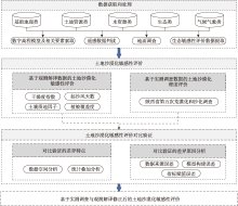
图2
研究框架"

表2
土地沙漠化敏感性分级标准"
| 评价因子 | 极敏感 | 敏感 | 一般敏感 |
|---|---|---|---|
| 干燥度指数 | ≥16.0 | 1.5~16.0 | <1.5 |
| 起沙风天数/d | ≥30.0 | 10.0~20.0 | <10.0 |
| 土壤质地/mm | 砂质 | 壤质、砾质 | 黏质、基岩 |
| 植被覆盖度/% | <0.2 | 0.2~0.6 | ≥0.6 |
表3
基于观测解译数据的陕西省土地沙漠化敏感性结构"
| 区域 | 一般敏感 | 敏感 | 极敏感 | |||||
|---|---|---|---|---|---|---|---|---|
| 面积/km2 | 比例/% | 面积/km2 | 比例/% | 面积/km2 | 比例/% | |||
| 西安市 | 10016.0 | 99.1 | 90.0 | 0.9 | 0.0 | 0.0 | ||
| 铜川市 | 3792.0 | 97.7 | 89.0 | 2.3 | 0.0 | 0.0 | ||
| 宝鸡市 | 17567.8 | 96.7 | 594.2 | 3.3 | 0.0 | 0.0 | ||
| 咸阳市 | 9874.7 | 96.0 | 408.3 | 4.0 | 0.0 | 0.0 | ||
| 渭南市 | 11527.5 | 88.4 | 1479.3 | 11.4 | 26.3 | 0.2 | ||
| 延安市 | 32304.6 | 87.2 | 4139.8 | 11.2 | 587.7 | 1.6 | ||
| 汉中市 | 27093.0 | 100.0 | 0.0 | 0.0 | 0.0 | 0.0 | ||
| 榆林市 | 4180.3 | 9.7 | 21369 | 49.8 | 17382.7 | 40.5 | ||
| 安康市 | 23535.0 | 100.0 | 0.0 | 0.0 | 0.0 | 0.0 | ||
| 商洛市 | 19581.0 | 100.0 | 0.0 | 0.0 | 0.0 | 0.0 | ||
| 陕西省 | 160591.3 | 78.1 | 27149.7 | 13.2 | 17883.3 | 8.7 | ||
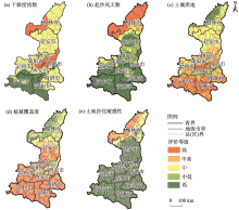
图3
基于观测解译数据的陕西省土地沙漠化敏感性空间分布"

表4
陕西省第五次荒漠化和沙化调查区域结构"
| 区域 | 沙漠化区域 | 未沙漠化区域 | |||
|---|---|---|---|---|---|
| 面积/km2 | 比例/% | 面积/km2 | 比例/% | ||
| 西安市 | 0.0 | 0.0 | 10106.0 | 100.0 | |
| 铜川市 | 0.0 | 0.0 | 3881.0 | 100.0 | |
| 宝鸡市 | 0.0 | 0.0 | 18162.0 | 100.0 | |
| 咸阳市 | 0.0 | 0.0 | 10283.0 | 100.0 | |
| 渭南市 | 0.0 | 0.0 | 13033.0 | 100.0 | |
| 延安市 | 0.0 | 0.0 | 37032.0 | 100.0 | |
| 汉中市 | 0.0 | 0.0 | 27093.0 | 100.0 | |
| 榆林市 | 411.8 | 9.6 | 43166.2 | 90.4 | |
| 安康市 | 0.0 | 0.0 | 23535.0 | 100.0 | |
| 商洛市 | 0.0 | 0.0 | 19581.0 | 100.0 | |
| 陕西省 | 411.8 | 0.3 | 205188.2 | 99.7 | |

图4
基于陕西省第五次荒漠化和沙化调查的沙漠化区域空间分布"

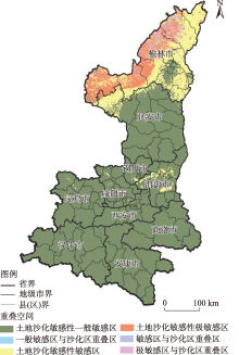
图5
陕西省土地沙漠化敏感性对比验证的空间差异"

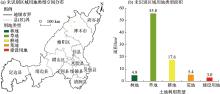
图6
土地沙漠化敏感性评价未识别区域用地类型"

表5
土地沙漠化敏感性评价未识别区域结构特征"
| 编号 | 林地 | 草地 | 耕地 | 荒地 | 建设用地 | |||||||||
|---|---|---|---|---|---|---|---|---|---|---|---|---|---|---|
| 面积/m2 | 权重/% | 面积/m2 | 权重/% | 面积/m2 | 权重/% | 面积/m2 | 权重/% | 面积/m2 | 权重/% | |||||
| 1 | 825000 | 29 | 2575000 | 11 | 707500 | 10 | 600000 | 18 | 415000 | 15 | ||||
| 2 | 542500 | 19 | 2032500 | 8 | 447500 | 6 | 340000 | 10 | 362500 | 13 | ||||
| 3 | 315000 | 11 | 1867500 | 8 | 445000 | 6 | 302500 | 9 | 272500 | 10 | ||||
| 4 | 157500 | 6 | 1787500 | 7 | 440000 | 6 | 287500 | 8 | 235000 | 9 | ||||
| 5 | 147500 | 5 | 1730000 | 7 | 440000 | 6 | 230000 | 7 | 217500 | 8 | ||||
| 6 | 125000 | 4 | 1600000 | 7 | 435000 | 6 | 202500 | 6 | 207500 | 8 | ||||
| 7 | 122500 | 4 | 1432500 | 6 | 422500 | 6 | 202500 | 6 | 162500 | 6 | ||||
| 8 | 102500 | 4 | 1275000 | 5 | 400000 | 6 | 185000 | 5 | 160000 | 6 | ||||
| 9 | 70000 | 2 | 1252500 | 5 | 387500 | 6 | 155000 | 5 | 95000 | 4 | ||||
| 10 | 50000 | 2 | 1205000 | 5 | 332500 | 5 | 155000 | 5 | 80000 | 3 | ||||
| 11 | 47500 | 2 | 1110000 | 5 | 330000 | 5 | 150000 | 4 | 80000 | 3 | ||||
| 12 | 45000 | 2 | 925000 | 4 | 290000 | 4 | 120000 | 4 | 77500 | 3 | ||||
| 13 | 45000 | 2 | 905000 | 4 | 272500 | 4 | 90000 | 3 | 77500 | 3 | ||||
| 14 | 35000 | 1 | 725000 | 3 | 235000 | 3 | 82500 | 2 | 57500 | 2 | ||||
| 15 | 32500 | 1 | 722500 | 3 | 232500 | 3 | 72500 | 2 | 45000 | 2 | ||||
| 16 | 32500 | 1 | 715000 | 3 | 232500 | 3 | 65000 | 2 | 35000 | 1 | ||||
| 17 | 32500 | 1 | 702500 | 3 | 227500 | 3 | 52500 | 2 | 35000 | 1 | ||||
| 18 | 32500 | 1 | 647500 | 3 | 207500 | 3 | 52500 | 2 | 25000 | 1 | ||||
| 19 | 32500 | 1 | 592500 | 2 | 205000 | 3 | 45000 | 1 | 25000 | 1 | ||||
| 20 | 30000 | 1 | 592500 | 2 | 195000 | 3 | 37500 | 1 | 22500 | 1 | ||||

图7
修正后的陕西省土地沙漠化敏感性评价结果空间分布"

表6
修正后的陕西省土地沙漠化敏感性结构"
| 区域 | 一般敏感 | 敏感 | 极敏感 | |||||
|---|---|---|---|---|---|---|---|---|
| 面积/km2 | 比例/% | 面积/km2 | 比例/% | 面积/km2 | 比例/% | |||
| 西安市 | 10102.0 | 99.2 | 84.1 | 0.8 | 0.0 | 0.0 | ||
| 铜川市 | 3824.2 | 97.6 | 92.3 | 2.4 | 0.0 | 0.0 | ||
| 宝鸡市 | 17679.2 | 99.7 | 56.7 | 0.3 | 0.0 | 0.0 | ||
| 咸阳市 | 9912.3 | 97.6 | 240.7 | 2.4 | 0.0 | 0.0 | ||
| 渭南市 | 11459.8 | 88.0 | 1541.5 | 11.8 | 26.3 | 0.2 | ||
| 延安市 | 32349.3 | 87.1 | 4236.2 | 11.4 | 558.8 | 1.5 | ||
| 汉中市 | 26818.5 | 100.0 | 0.0 | 0.0 | 0.0 | 0.0 | ||
| 榆林市 | 4180.2 | 16.2 | 4180.2 | 16.2 | 17408.6 | 67.6 | ||
| 安康市 | 23474.9 | 100.0 | 0.0 | 0.0 | 0.0 | 0.0 | ||
| 商洛市 | 19569.9 | 100.0 | 0.0 | 0.0 | 0.0 | 0.0 | ||
| 陕西省 | 159370.3 | 84.9 | 10431.7 | 5.5 | 17993.7 | 9.6 | ||
| [1] |
李振亚, 魏伟, 周亮, 等. 中国陆地生态敏感性时空演变特征[J]. 地理学报, 2022, 77(1): 150-163.
doi: 10.11821/dlxb202201011 |
|
[ Li Zhenya, Zhou Liang, et al. Spatio-temporal evolution characteristics of terrestrial ecological sensitivity in China[J]. Acta Geographica Sinica, 2022, 77(1): 150-163. ]
doi: 10.11821/dlxb202201011 |
|
| [2] | 苏凯. 北方国家生态屏障区生态系统格局、质量、服务及其辐射效应评估研究[D]. 北京: 北京林业大学, 2021. |
| [ Su Kai. Assessment of ecosystem pattern, quality, services and services radiation effect in national ecological security shelters of northern China[D]. Beijing: Beijing Forestry University, 2021. ] | |
| [3] | 王盛, 李亚文, 李庆, 等. 变化环境影响下张承地区水源涵养和土壤保持服务及其权衡与协同关系研究[J]. 生态学报, 2022, 42(13): 5391-5403. |
| [ Wang Sheng, Li Yawen, Li Qing, et al. Water and soil conservation and their trade-off and synergistic relationship under changing environment in Zhangjiakou-Chengde area[J]. Acta Ecologica Sinica, 2022, 42(13): 5391-5403. ] | |
| [4] | 周璐红, 王盼婷, 曹瑞超. 2000—2020年延安市土壤侵蚀驱动因素分析及生态安全评价[J]. 生态与农村环境学报, 2022, 38(4): 511-520. |
| [ Zhou Luhong, Wang Panting, Cao Ruichao. Soil erosion driving factors and ecological security evaluation for Yan’an City from 2000 to 2020[J]. Journal of Ecology and Rural Environment, 2022, 38(4): 511-520. ] | |
| [5] |
陈云, 李玉强, 王旭洋, 等. 中国生态脆弱区全球变化风险及应对技术途径和主要措施[J]. 中国沙漠, 2022, 42(3): 148-158.
doi: 10.7522/j.issn.1000-694X.2021.00145 |
|
[ Chen Yun, Li Yuqiang, Wang Xuyang, et al. Risk and countermeasures of global change in ecologically vulnerable regions of China[J]. Journal of Desert Research, 2022, 42(3): 148-158. ]
doi: 10.7522/j.issn.1000-694X.2021.00145 |
|
| [6] | 魏婵娟, 蒙吉军. 中国土地资源生态敏感性评价与空间格局分析[J]. 北京大学学报(自然科学版), 2022, 58(1): 157-168. |
| [ Wei Chanjuan, Meng Jijun. Ecological sensitivity assessment and spatial pattern analysis of land resources in China[J]. Acta Scientiarum Naturalium Universitatis Pekinensis, 2022, 58(1): 157-168. ] | |
| [7] | Kosmas C, Kirkby M, Geeson N. The Medalus project: Mediterranean desertification and land use[C]// Manual on Key Indicators of Desertification and Mapping Environmental Sensitive Areas to Desertification. Luxembourg: European Commission-Office for Official Publications of the European Communities, 1999: 31-47. |
| [8] | 于宏源. 全球环境治理内涵及趋势研究[M]. 上海: 上海人民出版社, 2018: 120-215. |
| [ Yu Hongyuan. Study on the connotation and trends of global environmental governance[M]. Shanghai: Shanghai People’s Publishing House, 2018: 120-215. ] | |
| [9] |
Aliero M M, Ismail M H, Alias M A, et al. Geospatial analysis of desertification vulnerability using Mediterranean desertification and land use (MEDALUS) model in Kebbi State, Nigeria[J]. Applied Geomatics, 2021, 13(4): 527-536.
doi: 10.1007/s12518-021-00372-5 |
| [10] |
Ferrara A, Kosmas C, Salvati L, et al. Updating the MEDALUS-ESA framework for worldwide land degradation and desertification assessment[J]. Land Degradation & Development, 2020, 31(12): 1593-1607.
doi: 10.1002/ldr.v31.12 |
| [11] |
Lee E J, Piao D, Song C, et al. Assessing environmentally sensitive land to desertification using MEDALUS method in Mongolia[J]. Forest Science and Technology, 2019, 15(4): 210-220.
doi: 10.1080/21580103.2019.1667880 |
| [12] |
Ait Lamqadem A, Pradhan B, Saber H, et al. Desertification sensitivity analysis using MEDALUS model and GIS: A case study of the oases of middle Draa Valley, Morocco[J]. Sensors, 2018, 18(7): 22-30.
doi: 10.3390/s18010022 |
| [13] | 张云芝, 胡云锋, 韩月琪, 等. 全球主要生态退化区和研究热点区的空间分布与演变[J]. 生态学报, 2021, 41(19): 7599-7613. |
| [ Zhang Yunzhi, Hu Yunfeng, Han Yueqi, et al. Spatial distributions and evolutions of global major ecological degradation regions and research hotspot regions[J]. Acta Ecologica Sinica, 2021, 41(19): 7599-7613. ] | |
| [14] |
Song C, Kim W, Kim J, et al. Spatial assessment of land degradation using MEDALUS focusing on potential afforestation and reforestation areas in Ethiopia[J]. Land Degradation & Development, 2022, 33(1): 79-93.
doi: 10.1002/ldr.v33.1 |
| [15] | Elnashar A, Zeng H, Wu B, et al. Assessment of environmentally sensitive areas to desertification in the Blue Nile Basin driven by the MEDALUS-GEE framework[J]. Science of the Total Environment, 2022, 815: 152925, doi: 10.1016/j.scitotenv.2022.152925. |
| [16] | 欧阳志云, 王效科, 苗鸿. 中国生态环境敏感性及其区域差异规律研究[J]. 生态学报, 2000, 20(1): 10-13. |
| [ Ouyang Zhiyun, Wang Xiaoke, Miao Hong. China’s eco-environmental sensitivity and its spatial heterogeneity[J]. Acta Ecologica Sinica, 2000, 20(1): 10-13. ] | |
| [17] | 胡梦甜, 张慧, 高吉喜, 等. 基于RWEQ模型修正的土地沙化敏感性评价[J]. 水土保持研究, 2021, 28(1): 368-372. |
| [ Hu Mengtian, Zhang Hui, Gao Jixi, et al. RWEQ-based assessment on sensitivity of land desertification[J]. Research of Soil and Water Conservation, 2021, 28(1): 368-372. ] | |
| [18] | 刘耕源, 王雪琪, 王宣桦, 等. 城市生态承载力理论与提升逻辑:历史性、关联性与非线性[J]. 北京师范大学学报(自然科学版), 2021, 57(5): 733-744. |
| [ Lu Gengyuan, Wang Xueqi, Wang Xuanhua, et al. Theory and improvement pathway of urban ecological carrying capacity: Historicity, nexus and nonlinearity[J]. Journal of Beijing Normal University (Natural Science Edition), 2021, 57(5): 733-744. ] | |
| [19] | 程功, 吴左宾. 县域国土综合整治与生态修复框架及实践[J]. 规划师, 2020, 36(17): 35-40. |
| [ Cheng Gong, Wu Zuobin. Comprehensive land consolidation and ecological restoration of counties[J]. Planners, 2020, 36(17): 35-40. ] | |
| [20] | 王晓瑜. 生态环境审计研究——以黄河三角洲地区为例[J]. 湖北经济学院学报(人文社会科学版), 2021, 18(12): 62-67. |
| [ Wang Xiaoyu. Study on ecological environment audit: Taking the Yellow River Delta region as an example[J]. Journal of Hubei University of Economics: Humanities and Social Sciences, 2021, 18(12): 62-67. ] | |
| [21] |
傅伯杰, 张立伟. 土地利用变化与生态系统服务:概念、方法与进展[J]. 地理科学进展, 2014, 33(4): 441-446.
doi: 10.11820/dlkxjz.2014.04.001 |
|
[ Fu Bojie, Zhang Liwei. Land-use change and ecosystem services: Concepts, methods and progress[J]. Progress in Geography, 2014, 33(4): 441-446. ]
doi: 10.11820/dlkxjz.2014.04.001 |
|
| [22] |
Gardner T A, Barlow J, Sodhi N S, et al. A multi-region assessment of tropical forest biodiversity in a human-modified world[J]. Biological Conservation, 2010, 143(10): 2293-2300.
doi: 10.1016/j.biocon.2010.05.017 |
| [23] | 陈莎. 基于生态系统服务权衡的农地格局与利用决策研究[D]. 杭州: 浙江大学, 2021. |
| [ Chen Sha. Mainstreaming ecosystem services trade-offs into farmland use and livelihood strategies[D]. Hangzhou: Zhejiang University, 2021. ] | |
| [24] | 张涵. 基于生态敏感性评价的河流型湿地生态修复策略研究——以北京永定河长兴湿地郊野公园为例[D]. 北京: 北京林业大学, 2021. |
| [ Zhang Han. Ecological restoration strategy of river wetland based on ecological sensitivity evaluation: A case study of Changxing wetland country park in Yongding River, Beijing[D]. Beijing: Beijing Forestry University, 2021. ] | |
| [25] | 陈全. 喀斯特石漠化地区生态资产遥感评估及时空演变机制研究[D]. 贵阳: 贵州师范大学, 2021. |
| [ Chen Quan. Remote sensing assessment and spatiotemporal evolution mechanism analysis of ecological assets in karst rocky desertification area[D]. Guizhou: Guizhou Normal University, 2021. ] | |
| [26] | 黄友昕. 顾及时空多因素的农业干旱遥感监测方法及其适应性评价研究[D]. 北京: 中国地质大学, 2021. |
| [ Huang Youxin. Research on remote sensing derived agricultural drought monitoring method and its adaptability evaluation concerning spatiotemporal multi-factor[D]. Beijing: China University of Geosciences, 2021. ] | |
| [27] | 吴柯, 张研霞, 廖祥春. 摄影测量与遥感学[J]. 测绘文摘, 2010, 16(4):43-75. |
| [ Wu Ke, Zhang Yanxia, Liao Xiangchun. Photogrammetry and remote sensing[J]. Journal of Navigation and Positioning, 2010, 16(4): 43-75. ] | |
| [28] | 王保林. 内蒙古草甸草原区遥感生态评价与监测研究[D]. 呼和浩特: 内蒙古农业大学, 2020. |
| [ Wang Baolin. Study on ecological evaluation, monitoring of meadow steppe in Inner Mongolia based on remote sensing[D]. Hohhot: Inner Mongolia Agricultural University, 2020. ] | |
| [29] | 刘思源. 陕北农牧交错带沙地农业利用规模的水资源调控研究[D]. 西安: 西安理工大学, 2022. |
| [ Liu Siyuan. Study on the water resources regulation on the suitable scale of sandy land agricultural utilization in agro-pastoral ecotone of northern Shaanxi[D]. Xi’an: Xi’an University of Technology, 2022. ] | |
| [30] |
柳利利, 韩磊, 韩永贵, 等. 1989—2019年西北地区干燥度指数时空变化及其对气候因子的响应[J]. 应用生态学报, 2021, 32(11): 4050-4058.
doi: 10.13287/j.1001-9332.202111.014 |
|
[ Liu Lili, Han Lei, Han Yonggui, et al. Spatio-temporal variations of aridity index and its response to climate factors in northwest China during 1989—2019[J]. Chinese Journal of Applied Ecology, 2021, 32(11): 4050-4058. ]
doi: 10.13287/j.1001-9332.202111.014 |
|
| [31] | 高广磊, 殷小琳, 丁国栋, 等. 土壤风蚀可蚀性研究进展评述[J]. 中国水土保持科学, 2022, 20(1): 143-150. |
| [ Gao Guanglei, Yin Xiaolin, Ding Guodong, et al. Soil erodibility for wind erosion: A critical review[J]. Science of Soil and Water Conservation, 2022, 20(1): 143-150. ] | |
| [32] |
徐玲玲, 延昊, 钱拴. 基于MODIS-NDVI的2000—2018年中国北方土地沙化敏感性时空变化[J]. 自然资源学报, 2020, 35(4): 925-936.
doi: 10.31497/zrzyxb.20200414 |
|
[ Xu Lingling, Yan Hao, Qian Shuan. Spatio-temporal change of land desertification sensitivity in northern China from 2000 to 2018 based on MODIS-NDVI[J]. Journal of Natural Resources, 2020, 35(4): 925-936. ]
doi: 10.31497/zrzyxb.20200414 |
|
| [33] |
郭泽呈, 魏伟, 石培基, 等. 中国西北干旱区土地沙漠化敏感性时空格局[J]. 地理学报, 2020, 75(9): 1948-1965.
doi: 10.11821/dlxb202009010 |
|
[ Guo Zecheng, Shi Peiji, et al. Spatiotemporal changes of land desertification sensitivity in the arid region of northwest China[J]. Acta Geographica Sinica, 2020, 75(9): 1948-1965. ]
doi: 10.11821/dlxb202009010 |
|
| [34] | Holiaka D, Kato H, Yoschenko V, et al. Scots pine stands biomass assessment using 3D data from unmanned aerial vehicle imagery in the Chernobyl exclusion zone[J]. Journal of Environmental Management, 2021, 295: 113319, doi: 10.1016/j.jenvman.2021.113319. |
| [1] | 史维良, 车璐阳, 李涛. 陕西省汛期极端降水概率分布及综合危险性评估[J]. 干旱区地理, 2023, 46(9): 1407-1417. |
| [2] | 李洪庆,杨瑀,张俊红. 雅鲁藏布江山南宽谷流域生态安全格局构建[J]. 干旱区地理, 2023, 46(9): 1503-1513. |
| [3] | 丁华,廖文强,段丰浩,杨望暾. 陕西省丹霞地貌景观特征、空间分布与形成机理初探[J]. 干旱区地理, 2023, 46(4): 527-538. |
| [4] | 窦睿音, 张文洁, 陈晨. 陕西省“三生”空间格局演变与驱动机制研究[J]. 干旱区地理, 2023, 46(2): 264-273. |
| [5] | 余焕, 雷敏, 马金晶, 李睿. 基于绿色GDP和生态效率的区域可持续发展研究——以陕西省为例[J]. 干旱区地理, 2023, 46(2): 284-293. |
| [6] | 倪红红, 马强, 卜元坤, 杨小轩, 李卫忠. 陕西省林业企业时空格局演变及影响因素分析[J]. 干旱区地理, 2023, 46(12): 2098-2110. |
| [7] | 刘畅,李诚志,李胜辉,付小磊,师庆东. 基于栅格累加法的塔里木盆地沙漠化分析[J]. 干旱区地理, 2021, 44(1): 197-207. |
| [8] | 申雨晨,李双双,延军平,武亚群,汪成博. 极点对称模态分解下陕西气候变化特征及影响因素[J]. 干旱区地理, 2021, 44(1): 36-46. |
| [9] | 雷杨娜, 张侠, 赵晓萌. 1971—2018 年陕西省人体舒适度时空分布特征研究[J]. 干旱区地理, 2020, 43(6): 1417-1425. |
| [10] | 王博, 黄晓军, 刘萌萌 . 区域建设用地开发强度格局演化及影响因素分析 ——以陕西省为例[J]. 干旱区地理, 2020, 43(6): 1635-1647. |
| [11] | 夏玮静, 王宁练, 沈月. 基于流域的陕西省水资源承载力研究 [J]. 干旱区地理, 2020, 43(3): 602-611. |
| [12] | 米瑞华, 高向东.
陕西省人口分布影响因素的空间计量分析 [J]. 干旱区地理, 2020, 43(2): 491-498. |
| [13] | 钱琛, 陈海滨, 侯现慧. 生态建设背景下陕西省植被覆盖时空变化及其影响因素研究 [J]. 干旱区地理, 2020, 43(2): 425-433. |
| [14] | 温煜华, 王乃昂, 严欣荣. 黄河重要水源补给区生态红线划定研究[J]. 干旱区地理, 2019, 42(6): 1445-1453. |
| [15] | 胡琳, 张侠, 苏静, 王琦, 胡淑兰. 陕西省霾天气变化特征及气候成因分析[J]. 干旱区地理, 2019, 42(4): 707-714. |
|
||