干旱区地理 ›› 2026, Vol. 49 ›› Issue (9): 1826-1839.doi: 10.12118/j.issn.1000-6060.2025.703 cstr: 32274.14.ALG2025703
毕文焌1,2( ), 闫庆武1,3(), 赵甫心3, 移明昊3, 吴子豪1,3
收稿日期:2025-10-30
修回日期:2025-11-21
出版日期:2026-09-25
发布日期:2026-09-07
通讯作者:
闫庆武(1975-),男,博士,教授,主要从事土地生态监测研究. E-mail: yanqingwu@cumt.edu.cn作者简介:毕文焌(2002-),男,硕士研究生,主要从事土地生态监测研究. E-mail: ts24160142p31@cumt.edu.cn
基金资助:
BI Wenjun1,2(), YAN Qingwu1,3(), ZHAO Fuxin3, YI Minghao3, WU Zihao1,3
Received:2025-10-30
Revised:2025-11-21
Published:2026-09-25
Online:2026-09-07
摘要:
景观生态风险是指区域景观结构的改变对生态过程造成的潜在不良影响,深入研究其时空分异特征及驱动因素,可以为国土空间优化提供决策支撑。以天山中段为研究对象,采用景观生态风险评价模型研究2005—2023年景观生态风险的时空变化格局,并基于极限梯度提升-沙普利加性解释(XGBoost-SHAP)方法,探究了景观生态风险驱动因素及其交互作用。结果表明:(1) 时间维度上,2005—2023年天山中段景观生态风险总体平稳,景观生态风险指数(ERI)微降。期间,66.12%区域风险等级稳定,33.88%区域有升降转换,局部敏感性与整体稳态并存。(2) 空间格局上,天山中段景观生态风险呈“北低南高”两极化格局,以天山主脊为界近似“人”字形分隔。高风险区集中于天山南部塔克拉玛干沙漠地带,低风险区集中于北部的伊犁河谷地带,景观组成对风险空间分异影响显著。(3) 驱动因素上,单因素分析中自然地理因素主导天山中段景观生态风险格局,其中归一化植被指数(NDVI)与气温贡献突出。交互因素分析中高景观生态风险区域受“低NDVI与较高气温”和“低GDP与高人口密度”耦合驱动,这种多重阈值非线性互馈机制是干旱区生态风险管理需重点关注的内容。
毕文焌, 闫庆武, 赵甫心, 移明昊, 吴子豪. 基于XGBoost-SHAP方法的天山中段景观生态风险时空演变及驱动因素[J]. 干旱区地理, 2026, 49(9): 1826-1839.
BI Wenjun, YAN Qingwu, ZHAO Fuxin, YI Minghao, WU Zihao. Spatiotemporal evolution and driving factors of landscape ecological risk in the middle section of the Tianshan Mountains based on the XGBoost-SHAP method[J]. Arid Land Geography, 2026, 49(9): 1826-1839.
图1
研究区示意图 注:基于自然资源部标准地图服务网站审图号为GS(2024)0650号的标准地图制作,底图边界无修改。克州、巴州、昌吉州、伊犁州直、博州分别为克孜勒苏柯尔克孜自治州、巴音郭楞蒙古自治州、昌吉回族自治州、伊犁哈萨克自治州直属县市、博尔塔拉蒙古自治州的简称。下同。"
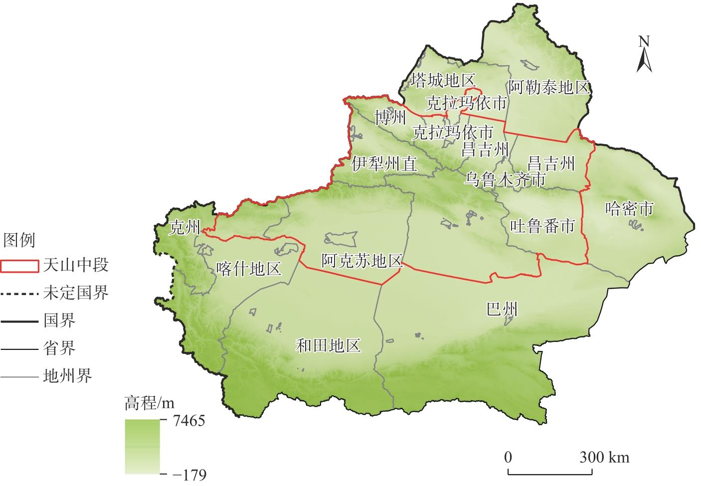

表1
驱动因素指标"
| 数据类型 | 数据名称 | 数据来源 |
|---|---|---|
| 自然地 理因素 | NDVI | 国家青藏高原科学数据中心( |
| 坡度 | 由高程在ArcGIS中计算得到 | |
| 降水量 | 国家地球系统科学数据中心( | |
| 气温 | 国家地球系统科学数据中心( | |
| 社会经 济因素 | 人口密度 | 美国能源部橡树岭国家实验室( |
| GDP | 中国科学院资源环境科学数据中心( |
表2
景观生态风险相关指数计算"
| 相关指数 | 计算公式 | 变量含义 |
|---|---|---|
| 景观损失度(Ri) | Ri=Vi×Di | Vi为第i类景观的景观脆弱度;Di为第i类景观的景观干扰度 |
| 景观脆弱度(Vi) | 归一化处理 | 根据前人研究[ |
| 景观干扰度(Di) | Di=a×Ci+b×Ni+c×Fi | a、b和c分别为Ci、Ni和Fi的权重,且a+b+c=1,根据相关研究[ |
| 景观破碎度(Ci) | ni为第i类景观的斑块数量;Ai为第i类景观的总面积(km2) | |
| 景观分离度(Ni) | A为景观总面积(km2) | |
| 景观分维数(Fi) | Pi为第i类景观的周长(km) |
图2
2005—2023年天山中段景观格局指数的变化"
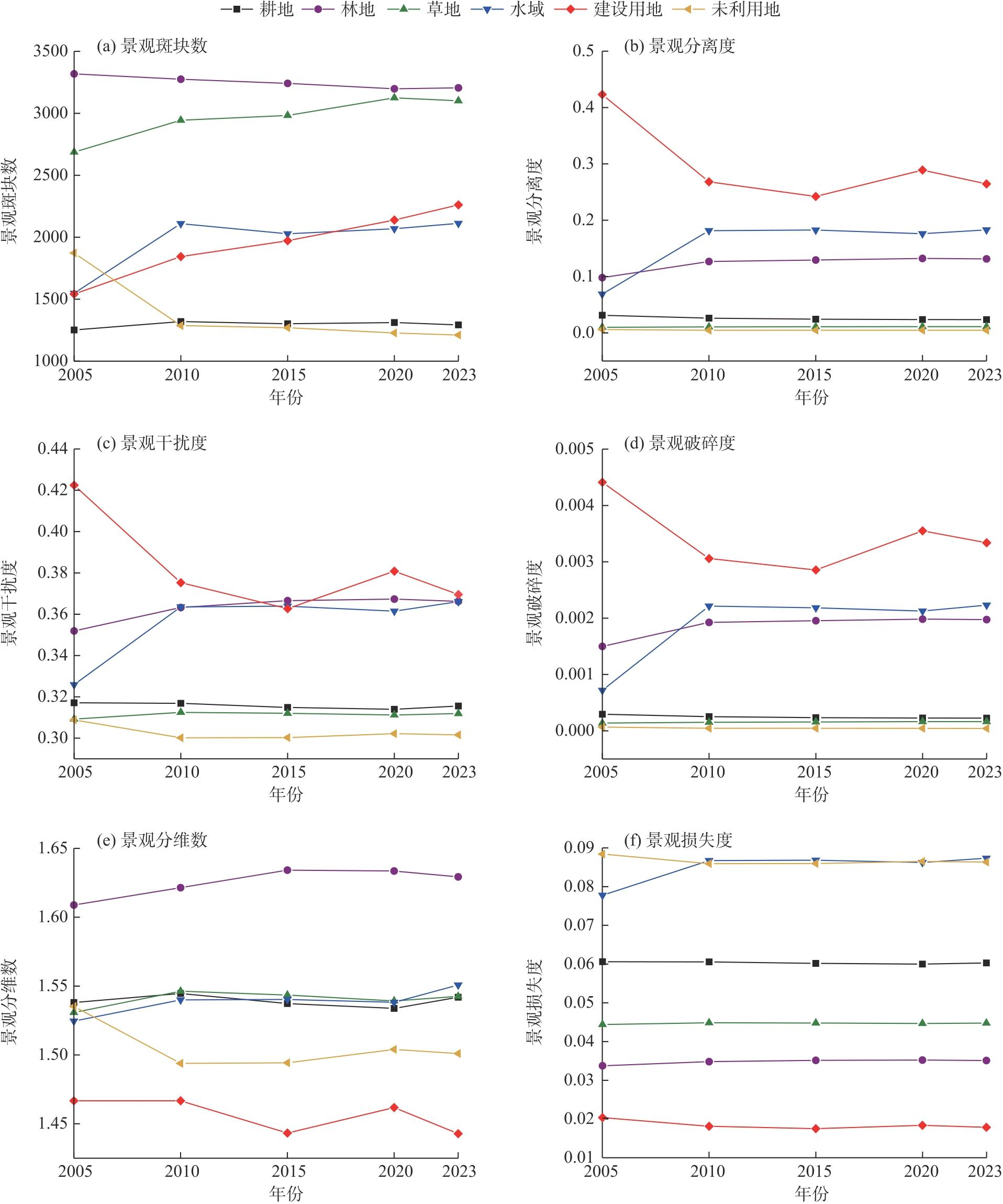
图3
2005—2023年天山中段景观生态风险空间分布"
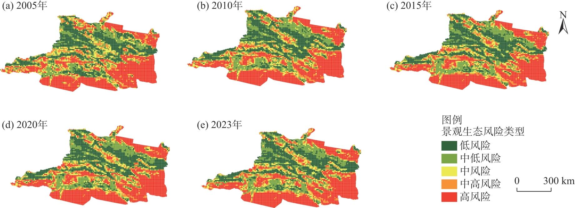
表3
2005—2023年景观生态风险的面积及占比"
| 景观生态 风险类型 | 2005年 | 2010年 | 2015年 | 2020年 | 2023年 | |||||||||
|---|---|---|---|---|---|---|---|---|---|---|---|---|---|---|
| 面积/104 km2 | 占比/% | 面积/104 km2 | 占比/% | 面积/104 km2 | 占比/% | 面积/104 km2 | 占比/% | 面积/104 km2 | 占比/% | |||||
| 低风险 | 13.34 | 23.52 | 13.29 | 23.43 | 13.38 | 23.59 | 13.33 | 23.50 | 13.19 | 23.26 | ||||
| 中低风险 | 10.07 | 17.75 | 11.12 | 19.60 | 11.16 | 19.68 | 10.98 | 19.36 | 11.13 | 19.62 | ||||
| 中风险 | 7.13 | 12.57 | 6.13 | 10.81 | 6.00 | 10.58 | 6.21 | 10.95 | 6.32 | 11.14 | ||||
| 中高风险 | 6.50 | 11.46 | 6.34 | 11.18 | 6.18 | 10.89 | 6.11 | 10.77 | 6.21 | 10.95 | ||||
| 高风险 | 19.68 | 34.70 | 19.84 | 34.98 | 20.00 | 35.26 | 20.09 | 35.42 | 19.87 | 35.03 | ||||
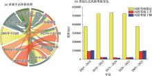
图4
2005—2023年天山中段景观生态风险面积转移"

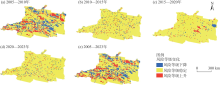
图5
2005—2023年天山中段景观生态风险水平变化空间分布"
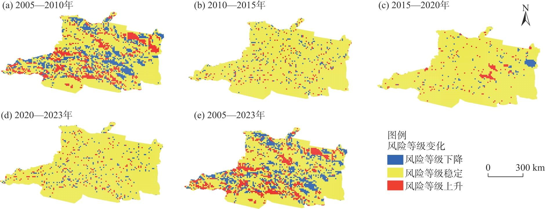
图6
景观生态风险驱动因素重要性排序 注:NDVI为归一化植被指数;GDP为地区生产总值;SHAP为沙普利加性解释。下同。"
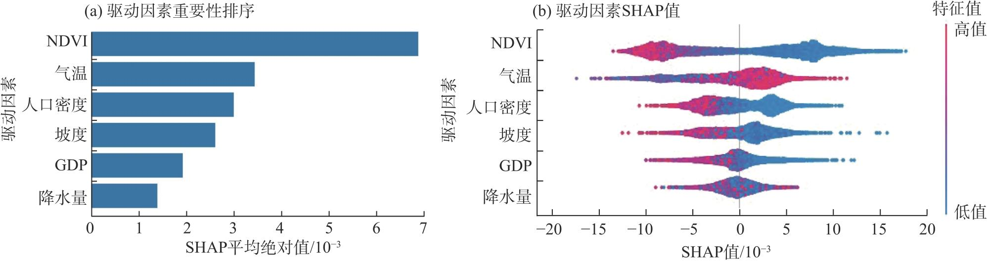
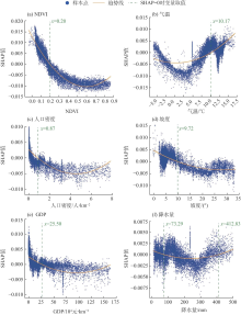
图7
景观生态风险驱动因素非线性特征"

图8
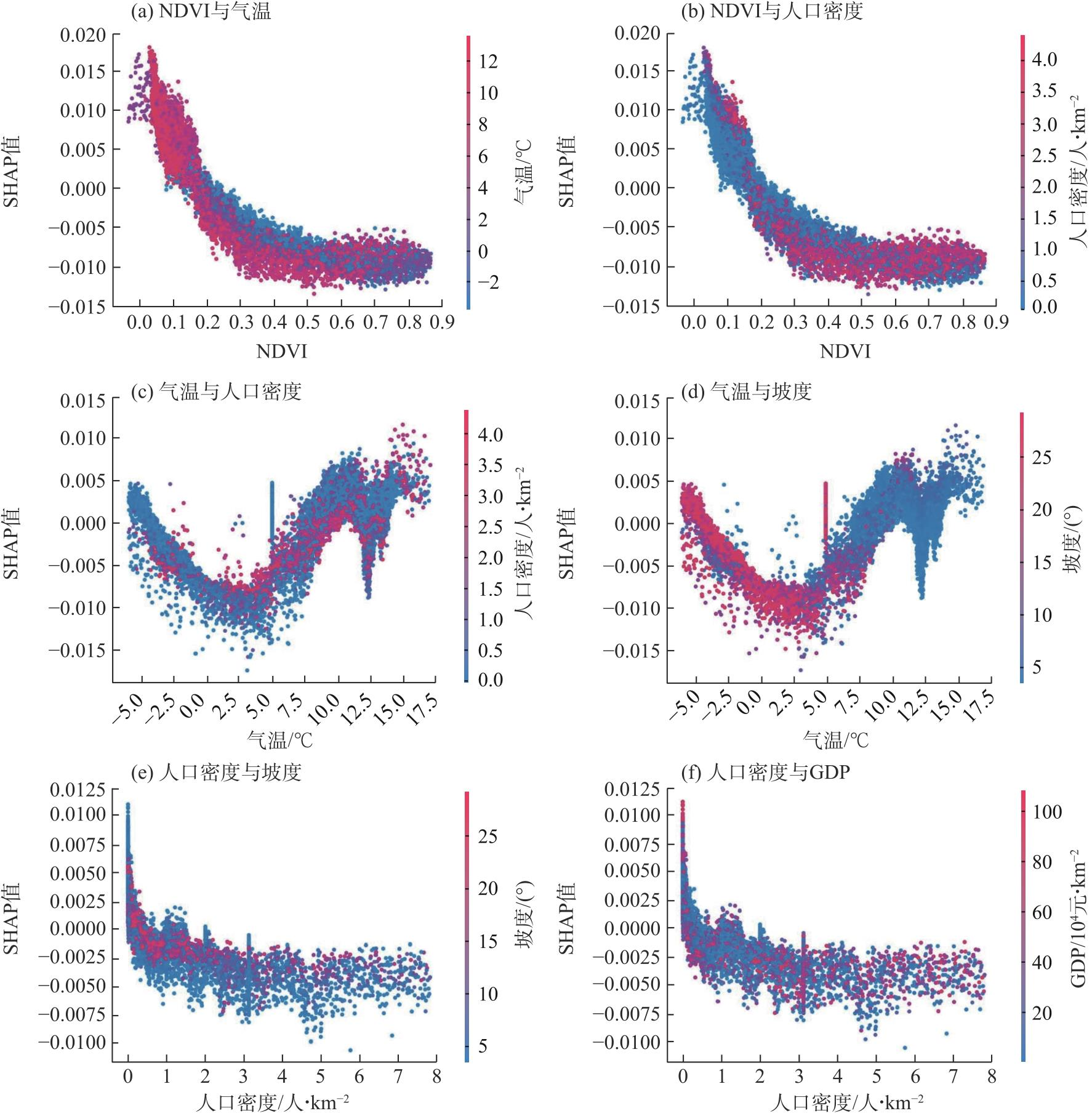
景观生态风险驱动因素的交互作用"
| [1] | 蔡文博, 王薇, 朱青, 等. 基于谷歌地球引擎大数据支撑的自然资源生态安全应用研究进展[J]. 生态学报, 2025, 45(7): 3544-3554. |
| [Cai Wenbo, Wang Wei, Zhu Qing, et al. Research progress and prospects of natural resource ecological security applications supported by GEE-based earth big data[J]. Acta Ecologica Sinica, 2025, 45(7): 3544-3554.] | |
| [2] |
彭建, 党威雄, 刘焱序, 等. 景观生态风险评价研究进展与展望[J]. 地理学报, 2015, 70(4): 664-677.
doi: 10.11821/dlxb201504013 |
|
[Peng Jian, Dang Weixiong, Liu Yanxu, et al. Review on landscape ecological risk assessment[J]. Acta Geographica Sinica, 2015, 70(4): 664-677.]
doi: 10.11821/dlxb201504013 |
|
| [3] | Shamuxi A, Han B, Jin X B, et al. Spatial pattern and driving mechanisms of dryland landscape ecological risk: Insights from an integrated geographic detector and machine learning model[J]. Ecological Indicators, 2025, 172: 113305, doi: 10.1016/j.ecolind.2025.113305. |
| [4] |
张子涵, 王瑾杰, 丁建丽, 等. 基于PLUS模型的艾比湖流域景观生态风险分析及预测[J]. 干旱区地理, 2025, 48(2): 308-322.
doi: 10.12118/j.issn.1000-6060.2024.320 |
|
[Zhang Zihan, Wang Jinjie, Ding Jianli, et al. Analysis and prediction of landscape ecological risk in Ebinur Lake Basin based on PLUS model[J]. Arid Land Geography, 2025, 48(2): 308-322.]
doi: 10.12118/j.issn.1000-6060.2024.320 |
|
| [5] | 康紫薇, 张正勇, 位宏, 等. 基于土地利用变化的玛纳斯河流域景观生态风险评价[J]. 生态学报, 2020, 40(18): 6472-6485. |
| [Kang Ziwei, Zhang Zhengyong, Wei Hong, et al. Landscape ecological risk assessment in Manas River Basin based on land use change[J]. Acta Ecologica Sinica, 2020, 40(18): 6472-6485.] | |
| [6] | 杨庚, 张振佳, 曹银贵, 等. 晋北大型露天矿区景观生态风险时空异质性[J]. 生态学杂志, 2021, 40(1): 187-198. |
|
[Yang Geng, Zhang Zhenjia, Cao Yingui, et al. Spatial-temporal heterogeneity of landscape ecological risk of large-scale open-pit mining area in north Shanxi[J]. Chinese Journal of Ecology, 2021, 40(1): 187-198.]
doi: : 10.13292/j.1000-4890.202101.003 |
|
| [7] |
高彬嫔, 李琛, 吴映梅, 等. 川滇生态屏障区景观生态风险评价及影响因素[J]. 应用生态学报, 2021, 32(5): 1603-1613.
doi: 10.13287/j.1001-9332.202105.018 |
|
[Gao Binpin, Li Chen, Wu Yingmei, et al. Landscape ecological risk assessment and influencing factors in ecological conservation area in Sichuan-Yunnan provinces, China[J]. Chinese Journal of Applied Ecology, 2021, 32(5): 1603-1613.]
doi: 10.13287/j.1001-9332.202105.018 |
|
| [8] | He Q C, Zhang Z H, Zhang Y, et al. Spatiotemporal evolution and driving mechanisms of ecological risk in the Yuncheng Salt Lake Wetland, China[J]. Water, 2025, 17(4): 524, doi: 10.3390/w17040524. |
| [9] | 侯蕊, 李红波, 高艳丽. 基于景观格局的武汉市江夏区土地利用生态风险评价[J]. 水土保持研究, 2021, 28(1): 323-330, 403. |
| [Hou Rui, Li Hongbo, Gao Yanli. Ecological risk assessment of land use in Jiangxia District of Wuhan based on landscape pattern[J]. Research of Soil and Water Conservation, 2021, 28(1): 323-330, 403.] | |
| [10] | 魏鹏, 余敦, 胡海洋, 等. 立体空间视角下景观生态风险时空演化及影响因素分析[J]. 农业工程学报, 2024, 40(19): 250-261. |
| [Wei Peng, Yu Dun, Hu Haiyang, et al. Spatial-temporal evolution and influencing factors of landscape ecological risk from the perspective of three-dimensional space[J]. Transactions of the Chinese Society of Agricultural Engineering, 2024, 40(19): 250-261.] | |
| [11] | Yan Z Y, Wang Y Q, Wang Z, et al. Spatiotemporal analysis of landscape ecological risk and driving factors: A case study in the Three Gorges Reservoir Area, China[J]. Remote Sensing, 2023, 15(19): 4884, doi: 10.3390/rs15194884. |
| [12] |
巩小维, 周冬梅, 张军, 等. “三生空间”视角下庆阳市景观生态风险评价及耦合协调度[J]. 干旱区研究, 2025, 42(3): 556-567.
doi: 10.13866/j.azr.2025.03.15 |
|
[Gong Xiaowei, Zhou Dongmei, Zhang Jun, et al. Landscape ecological risk evaluation and degree of coupling coordination in Qingyang City from the perspective of production-living-ecological space[J]. Arid Zone Research, 2025, 42(3): 556-567.]
doi: 10.13866/j.azr.2025.03.15 |
|
| [13] | 陈静, 程希平, 王倩娜, 等. 云南省弥勒市景观生态风险与碳储量服务的变化评估[J]. 中国生态农业学报(中英文), 2025, 33(4): 632-645. |
| [Chen Jing, Cheng Xiping, Wang Qianna, et al. Assessment and prediction of landscape ecological risk and carbon storage service changes in Mile City, Yunnan Province[J]. Chinese Journal of Eco-Agriculture, 2025, 33(4): 632-645.] | |
| [14] |
张舒涵, 姜海玲, 于海淋, 等. 沈阳现代化都市圈景观生态风险时空演变及驱动力分析[J]. 生态环境学报, 2024, 33(9): 1471-1481.
doi: 10.16258/j.cnki.1674-5906.2024.09.014 |
| [Zhang Shuhan, Jiang Hailing, Yu Hailin, et al. Spatio-temporal evolution and driving force analysis of landscape ecological risk in Shenyang modern metropolitan[J]. Ecology and Environmental Sciences, 2024, 33(9): 1471-1481.] | |
| [15] | Li M R, Abuduwaili J, Liu W, et al. Application of geographical detector and geographically weighted regression for assessing landscape ecological risk in the Irtysh River Basin, Central Asia[J]. Ecological Indicators, 2024, 158: 111540, doi: 10.1016/j.ecolind.2023.111540. |
| [16] | 许静, 廖星凯, 甘崎旭, 等. 耦合GMOP与FLUS模型的黄河流域甘肃段生态风险评估与预测[J]. 生态学杂志, 2024, 43(5): 1498-1508. |
|
[Xu Jing, Liao Xingkai, Gan Qixu, et al. Assessment and prediction of ecological risk in Gansu section of the Yellow River Basin coupled with GMOP and FLUS models[J]. Chinese Journal of Ecology, 2024, 43(5): 1498-1508.]
doi: 10.13292/j.1000-4890.202405.040 |
|
| [17] | 罗芹芹, 刘凤莲. 赤水河流域(贵州段)景观生态风险时空演变及驱动力探索[J]. 中国生态农业学报(中英文), 2025, 33(3): 550-562. |
| [Luo Qinqin, Liu Fenglian. Spatial-temporal evolution and driving forces of landscape ecological risk in the Chishui River Basin (Guizhou section)[J]. Chinese Journal of Eco-Agriculture, 2025, 33(3): 550-562.] | |
| [18] | 沙清泉, 黄麟, 樊江文, 等. 青藏铁路格-拉段沿线景观生态风险时空动态及其驱动机制[J]. 生态学报, 2024, 44(19): 8726-8736. |
| [Sha Qingquan, Huang Lin, Fan Jiangwen, et al. Spatio-temporal dynamics and their driving mechanisms of the landscape ecological risk along the Golmud-Lhasa section of Qinghai-Xizang Railway[J]. Acta Ecologica Sinica, 2024, 44(19): 8726-8736.] | |
| [19] | Zhang J Y, Qiao X N, Yang Y J, et al. Ecological security driving mechanisms and optimization of zoning in Chinese urban agglomerations: A case study of the central plains urban agglomeration[J]. Ecological Indicators, 2025, 171: 113190, doi: 10.1016/j.ecolind.2025.113190. |
| [20] | 张雪茂, 董廷旭, 杜华明, 等. 涪江流域景观生态风险空间异质性特征分析[J]. 水土保持研究, 2022, 29(3): 156-163. |
| [Zhang Xuemao, Dong Tingxu, Du Huaming, et al. Analysis on spatial heterogeneity of landscape ecological risk in Fujiang River Basin[J]. Research of Soil and Water Conservation, 2022, 29(3): 156-163.] | |
| [21] | 郭振敏, 汲玉河, 周广胜, 等. 基于机器学习的兴安落叶松生态系统在不同时间尺度的碳通量模拟及影响因素分析[J]. 生态学报, 2025, 45(16): 8139-8153. |
| [Guo Zhenmin, Ji Yuhe, Zhou Guangsheng, et al. Carbon flux simulation and analysis of influencing factors in the Larix gmelinii ecosystem at different time scales based on machine learning[J]. Acta Ecologica Sinica, 2025, 45(16): 8139-8153.] | |
| [22] | Song Y X, Niu R Q, Xu S L, et al. Landslide susceptibility mapping based on weighted gradient boosting decision tree in Wanzhou section of the Three Gorges Reservoir Area (China)[J]. ISPRS International Journal of Geo-Information, 2018, 8(1): 4, doi: 10.3390/ijgi8010004. |
| [23] | 张晓彤, 刘明月, 郎红梅, 等. 基于无人机多光谱和机器学习的芦苇地上生物量反演研究[J]. 生态学报, 2025, 45(15): 7314-7325. |
| [Zhang Xiaotong, Liu Mingyue, Lang Hongmei, et al. Phragmites australis aboveground biomass inversion based on UAV and machine learning[J]. Acta Ecologica Sinica, 2025, 45(15): 7314-7325.] | |
| [24] | 武强, 王潇, 赵颖旺, 等. 基于煤层底板标高控制区水量均衡的矿井突涌水蔓延模拟与应用[J]. 中国矿业大学学报, 2025, 54(3): 545-560. |
| [Wu Qiang, Wang Xiao, Zhao Yingwang, et al. Simulation and application of mine water inrush spreading based on water balance in the control area of coal seam floor elevation[J]. Journal of China University of Mining & Technology, 2025, 54(3): 545-560.] | |
| [25] | Zhuang X Y, Guo H W, Alajlan N, et al. Deep autoencoder based energy method for the bending, vibration, and buckling analysis of Kirchhoff plates with transfer learning[J]. European Journal of Mechanics, A/Solids, 2021, 87: 104225, doi: 10.1016/j.euromechsol.2021.104225. |
| [26] | 余红玲, 王晓玲, 任炳昱, 等. 土石坝渗流性态分析的IAO-XGBoost集成学习模型与预测结果解释[J]. 水利学报, 2023, 54(10): 1195-1209. |
| [Yu Hongling, Wang Xiaoling, Ren Bingyu, et al. IAO-XGBoost ensemble learning model for seepage behavior analysis of earth-rock dam and interpretation of prediction results[J]. Journal of Hydraulic Engineering, 2023, 54(10): 1195-1209.] | |
| [27] | Wang W T, Li D Z, Zhou S H, et al. Exploring the key influencing factors of low-carbon innovation from urban characteristics in China using interpretable machine learning[J]. Environmental Impact Assessment Review, 2024, 107: 107573, doi: 10.1016/j.eiar.2024.107573. |
| [28] |
刘妍, 孙延宁, 陈传法, 等. 城区数字高程模型修正方法: 顾及空间异质性的可解释随机森林模型[J]. 地球信息科学学报, 2024, 26(4): 978-988.
doi: 10.12082/dqxxkx.2024.230590 |
| [Liu Yan, Sun Yanning, Chen Chuanfa, et al. Improving urban digital elevation models based on interpretable random forest method considering spatial heterogeneity[J]. Journal of Geo-Information Science, 2024, 26(4): 978-988.] | |
| [29] |
谭洁, 危千骏, 廖朝阳, 等. 基于XGBoost-SHAP可解释机器学习模型的城市形态与地表温度的关系[J]. 应用生态学报, 2025, 36(3): 659-670.
doi: 10.13287/j.1001-9332.202503.025 |
|
[Tan Jie, Wei Qianjun, Liao Zhaoyang, et al. Relationship between urban form and surface temperature based on XGBoost SHAP interpretable machine learning model[J]. Chinese Journal of Applied Ecology, 2025, 36(3): 659-670.]
doi: 10.13287/j.1001-9332.202503.025 |
|
| [30] |
Zhou X Z, Wen H J, Li Z W, et al. An interpretable model for the susceptibility of rainfall-induced shallow landslides based on SHAP and XGBoost[J]. Geocarto International, 2022, 37(26): 13419-13450.
doi: 10.1080/10106049.2022.2076928 |
| [31] | 马小淞, 闫庆武, 移明昊, 等. 天山中段城市化水平与生态环境质量时空耦合研究[J]. 生态与农村环境学报, 2025, 41(2): 172-182. |
| [Ma Xiaosong, Yan Qingwu, Yi Minghao, et al. Research on the spatio-temporal coupling of urbanization and ecological environment quality in the middle section of the Tianshan Mountains[J]. Journal of Ecology and Rural Environment, 2025, 41(2): 172-182.] | |
| [32] | 于洋, 李明. 让世界看见开放自信的新疆[N]. 人民日报, 2025-05-28(11). |
| [Yu Yang, Li Ming. Let the world see an open and confident Xinjiang[N]. People’s Daily, 2025-05-28(11).] | |
| [33] |
程静, 王鹏, 陈红翔, 等. 半干旱区生态风险时空演变及其影响因素的地理探测——以宁夏盐池县为例[J]. 干旱区地理, 2022, 45(5): 1637-1648.
doi: 10.12118/j.issn.1000-6060.2022.033 |
|
[Cheng Jing, Wang Peng, Chen Hongxiang, et al. Geographical exploration of the spatial and temporal evolution of ecological risk and its influencing factors in semi-arid regions: A case of Yanchi County in Ningxia[J]. Arid Land Geography, 2022, 45(5): 1637-1648.]
doi: 10.12118/j.issn.1000-6060.2022.033 |
|
| [34] |
李思琪, 王海兵, 袁晓飞, 等. 毛乌素沙地景观生态风险时空演变及驱动力[J]. 中国沙漠, 2025, 45(5): 230-240.
doi: 10.7522/j.issn.1000-694X.2025.00129 |
|
[Li Siqi, Wang Haibing, Yuan Xiaofei, et al. Temporal and spatial evolution of landscape ecological risks and driving forces in the Mu Us Sandy Land[J]. Journal of Desert Research, 2025, 45(5): 230-240.]
doi: 10.7522/j.issn.1000-694X.2025.00129 |
|
| [35] | 王超龙, 薛莲, 张宜升, 等. 基于可解释性机器学习的滨海城市臭氧驱动因素[J]. 环境科学, 2025, 46(5): 2642-2653. |
|
[Wang Chaolong, Xue Lian, Zhang Yisheng, et al. Urban ozone driving factors based on explainable machine learning[J]. Environmental Science, 2025, 46(5): 2642-2653.]
doi: 10.1021/es202492h |
|
| [36] |
Santamouris M. Cooling the cities: A review of reflective and green roof mitigation technologies to fight heat island and improve comfort in urban environments[J]. Solar Energy, 2014, 103: 682-703.
doi: 10.1016/j.solener.2012.07.003 |
| [1] | 李晓鹏, 贾富贵, 雷双, 李康. 黄河流域农作物受灾时空演变特征及致灾因子[J]. 干旱区地理, 2026, 49(9): 1815-1825. |
| [2] | 焦视堂, 颜洋, 郑江华, 何莹, 巴比尔江·迪力夏提, 魏建新, 刘俊豪, 折勇睿. 新疆风电场对生态环境的影响特征及其驱动因素分析[J]. 干旱区地理, 2026, 49(9): 1840-1854. |
| [3] | 陈先林, 闫志远, 刘全明, 张圣微. 1958—2023年内蒙古植被干旱时空特征与驱动因素分析[J]. 干旱区地理, 2026, 49(7): 1323-1335. |
| [4] | 王紫洋, 夏咏, 王福红, 丁宁, 吕毅, 苏泽琛. 新疆县域耕地利用生态效率时空演变及驱动因素[J]. 干旱区地理, 2026, 49(7): 1385-1394. |
| [5] | 周莹洁, 陈浩. 丝绸之路中国段生态系统服务时空演变机制及其非线性阈值[J]. 干旱区地理, 2026, 49(7): 1445-1456. |
| [6] | 李文君, 张维梅. 中国数字经济与共同富裕的耦合协调关系及时空演进趋势[J]. 干旱区地理, 2026, 49(7): 1481-1492. |
| [7] | 付伟, 王煜承, 崔龙芳, 陈建成. 中国西部地区城乡居民食物消费碳排放差异与驱动因素分析[J]. 干旱区地理, 2026, 49(5): 1026-1038. |
| [8] | 何家豪, 侯光良, 敖民, 唐中华, 石洪飞. 基于MaxEnt的青藏高原细石器人群时空分布演变研究[J]. 干旱区地理, 2026, 49(5): 987-997. |
| [9] | 卢雅焱, 封甜, 杨兆萍, 韩芳, 贾莹莹. 中国省域新质生产力与旅游高质量发展适配度时空演变及障碍因子研究[J]. 干旱区地理, 2026, 49(4): 643-655. |
| [10] | 关靖云, 孙之阳, 徐晓亮, 程乙峰, 宋贝贝, 房瑞莹. 气候变化背景下中国新疆与中亚五国旅游气候舒适度时空演变分析[J]. 干旱区地理, 2026, 49(4): 697-712. |
| [11] | 陈文宣, 陈钰, 王生隆. 黄河流域农业碳排放时空演化特征及其影响因素分析[J]. 干旱区地理, 2026, 49(4): 713-726. |
| [12] | 刘法建, 梁婉欣, 黄超群, 李松渊, 张博涵. 中国旅游新质生产力发展时空演化特征与驱动因素[J]. 干旱区地理, 2026, 49(3): 429-439. |
| [13] | 朱怡婷, 梁桂仙, 周春山, 辛龙, 李金雪. 新疆文旅新质生产力发展时空演变特征与驱动因素[J]. 干旱区地理, 2026, 49(1): 128-139. |
| [14] | 于志翔, 于晓晶, 陈诗永, 李霞, 梅桢. 2000—2023年天山北坡城市群冬季大气污染事件时空演变特征[J]. 干旱区地理, 2026, 49(1): 35-46. |
| [15] | 刘全渝, 刘馨璐, 李桂真, 李从娟. 新疆表层土壤粒径分形特征及驱动因素分析[J]. 干旱区地理, 2026, 49(1): 56-68. |
|
||

