干旱区地理 ›› 2026, Vol. 49 ›› Issue (1): 56-68.doi: 10.12118/j.issn.1000-6060.2025.201 cstr: 32274.14.ALG2025201
刘全渝1,2( ), 刘馨璐1,2, 李桂真1, 李从娟2()
收稿日期:2025-04-13
修回日期:2025-07-03
出版日期:2026-01-25
发布日期:2026-01-18
通讯作者:
李从娟(1982-),女,博士,研究员,主要从事荒漠化防治与生态恢复研究. E-mail: licj@ms.xjb.ac.cn作者简介:刘全渝(2001-),男,硕士研究生,主要从事荒漠化防治与生态恢复研究. E-mail: liuquanyu12345@126.com
基金资助:
LIU Quanyu1,2(), LIU Xinlu1,2, LI Guizhen1, LI Congjuan2()
Received:2025-04-13
Revised:2025-07-03
Published:2026-01-25
Online:2026-01-18
摘要:
新疆是中国生态脆弱区和风蚀沙化灾害频发区,其表层土壤颗粒组成关系区域生态稳定。以新疆60个样地、180个样点表层土壤粒径为研究对象,通过干旱指数将采样点分为半干旱、干旱、极端干旱样地,探讨不同干旱梯度下土壤粒径分形特征和环境因子对新疆表土粒径分形特征的影响。结果表明:(1)随着干旱程度的增加,土壤表层颗粒分布逐渐粗化并呈现过渡性特征,半干旱、干旱样地土壤颗粒以粉粒为主,极端干旱样地土壤颗粒以砂粒为主,其中极细砂和细砂占比53.48%。(2)整体粒度特征分选较差,随着干旱程度增加,土壤颗粒的离散程度降低,分布区间更为集中,土壤分形维数集中在1.98~2.47之间。(3)分形维数受黏粒影响较大,与黏粒、粉粒呈显著正相关,与沙粒呈显著负相关,不同干旱梯度样地对分形维数拟合效果为极端干旱>干旱>半干旱。(4)因子探测器表明,年平均降水量(MAP)、年平均气温(MAT)、土壤类型、成土母质等因素对土壤分形维数解释较高。结构方程模型结果表明,本研究所选连续变量因子中,气候因子对新疆表层土壤分形维数影响显著,其中MAP与风速对分形维数为正向影响,MAT对分形维数为负向影响。研究结果可以为区域土壤利用、生态管理提供重要科学依据,进而有利于新疆的水土保持、植被恢复及生态系统稳定性。
刘全渝, 刘馨璐, 李桂真, 李从娟. 新疆表层土壤粒径分形特征及驱动因素分析[J]. 干旱区地理, 2026, 49(1): 56-68.
LIU Quanyu, LIU Xinlu, LI Guizhen, LI Congjuan. Fractal characteristics and driving factors of soil particle size in the surface layer of Xinjiang[J]. Arid Land Geography, 2026, 49(1): 56-68.
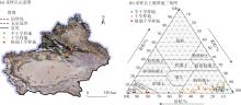
图1
研究区采样点与土壤质地三角图 注:基于自然资源部标准地图服务网站审图号为GS(2023)2763号的标准地图制作,底图边界无修改。"
表1
样地气候情况"
| 样地分类 | MAP/mm | MAT/℃ | AI |
|---|---|---|---|
| 半干旱样地 | 307.20±11.43 | 0.35±0.85 | 0.31±0.08 |
| 干旱样地 | 140.13±9.81 | 4.82±0.78 | 0.10±0.04 |
| 极端干旱样地 | 34.00±10.73 | 10.49±0.80 | 0.018±0.005 |
表2
粒度参数分级标准"
| 标准偏差( | 偏度( | 峰度( | |||||
|---|---|---|---|---|---|---|---|
| 分选级别 | 取值范围 | 偏度等级 | 取值范围 | 峰度等级 | 取值范围 | ||
| 极好 | 极负偏 | 很宽平 | |||||
| 好 | 负偏 | 宽平 | |||||
| 较好 | 近于对称 | 中等 | |||||
| 中等 | 正偏 | 尖窄 | |||||
| 较差 | 极正偏 | 很尖窄 | |||||
| 差 | 极尖窄 | ||||||
| 极差 | |||||||
表3
不同干旱梯度样地土壤颗粒组成描述性统计"
| 样地分类 | 黏粒/% | 粉粒/% | 砂粒/% | ||||
|---|---|---|---|---|---|---|---|
| 极细砂 | 细砂 | 中砂 | 粗砂 | 总量 | |||
| 半干旱样地 | 5.33±0.39a | 85.17±1.158a | 8.19±0.81c | 1.32±0.29b | 0.57±0.47a | 0.22±0.02a | 9.50±1.05c |
| 干旱样地 | 5.34±0.44a | 72.63±2.87b | 14.34±1.38b | 7.09±1.78b | 0.97±0.74a | 0.02±0.01a | 21.99±3.16b |
| 极端干旱样地 | 2.35±0.96b | 43.20±7.79c | 30.07±3.95a | 23.41±5.87a | 0.52±0.29a | 0.02±0.01a | 54.45±8.48a |
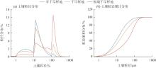
图2
不同干旱梯度样地粒径分布"
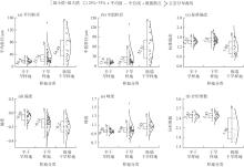
图3
不同干旱梯度样地土壤粒径参数 注:不同小写字母表示不同干旱梯度样地差异显著(P<0.05);图中数值为中位数。"

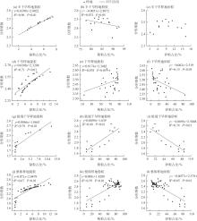
图4
不同样地土壤粒径占比与分形维数的关系 注:R2为决定系数,用于判断线性拟合模型的解释度。"

表4
不同成土母质下土壤颗粒组成差异"
| 母质类型 | 样本数 | 黏粒占比/% | 粉粒占比/% | 砂粒占比/% | 分形维数 |
|---|---|---|---|---|---|
| 坡、残积母质 | 102 | 5.32±0.42a | 75.31±3.17a | 19.37±3.40b | 2.45±0.03a |
| 洪、冲积母质 | 48 | 4.69±3.25a | 72.98±3.80a | 22.24±4.38b | 2.37±0.06a |
| 风积母质 | 21 | 1.07±1.65b | 24.63±7.41b | 74.29±7.97a | 2.01±0.15b |
| 黄土状母质 | 9 | 5.03±1.00a | 77.70±2.94a | 17.27±3.65b | 2.44±0.04a |
表5
不同土壤类型下土壤颗粒组成差异"
| 土壤类型 | 样本数 | 黏粒占比/% | 粉粒占比/% | 砂粒占比/% | 分形维数 |
|---|---|---|---|---|---|
| 风沙土 | 24 | 0.91±0.53b | 25.65±9.18c | 73.44±9.69a | 2.00±0.34b |
| 黑钙土 | 24 | 5.71±0.47a | 85.24±1.89a | 9.05±1.65bc | 2.47±0.05a |
| 黑毡土 | 9 | 6.20±0.53a | 87.16±0.82a | 6.64±0.55c | 2.49±0.03a |
| 冷钙土 | 9 | 4.55±0.9ab | 79.93±5.00ab | 15.52±9.01bc | 2.43±0.02a |
| 粟钙土 | 33 | 4.91±0.59ab | 78.72±2.97ab | 16.36±3.37bc | 2.45±0.02a |
| 盐土 | 15 | 3.88±1.15ab | 75.89±5.99ab | 20.23±6.87bc | 2.35±0.08a |
| 棕钙土 | 18 | 5.65±1.18a | 72.55±5.32b | 21.58±6.49bc | 2.47±0.03a |
| 棕漠土 | 24 | 6.32±1.16a | 64.27±4.31b | 29.41±5.27b | 2.46±0.09a |
表6
不同土地利用方式下土壤颗粒组成差异"
| 土地利用方式 | 样本数 | 黏粒占比/% | 粉粒占比/% | 砂粒占比/% | 分形维数 |
|---|---|---|---|---|---|
| 草地 | 123 | 4.85±0.42a | 71.29±20.28a | 23.85±3.45b | 2.42±0.03a |
| 林地 | 30 | 5.00±0.50a | 82.31±5.53a | 12.69±1.98b | 2.44±0.06a |
| 未利用土地 | 27 | 3.30±1.43a | 43.17±31.59b | 53.53±11.73a | 2.09±0.41b |
表7
不同干旱梯度样地环境特征"
| 样地分类 | ASL/m | 坡度 | 坡向 | BD/g·cm-3 | SWC/% |
|---|---|---|---|---|---|
| 半干旱样地 | 1994.33±161.92a | 7.46±1.21a | 175.66±27.70a | 82.91±6.74b | 23.76±3.46a |
| 干旱样地 | 1758.58±194.67ab | 4.22±0.87b | 175.75±22.50a | 119.01±6.51a | 8.75±1.88b |
| 极端干旱样地 | 1195.86±184.51b | 2.03±0.97b | 229.82±31.80a | 134.00±4.76a | 4.05±1.70c |
| 样地分类 | SOM/g·kg-1 | pH | EC/μS·cm-1 | NDVI | 风速/m·s-1 |
| 半干旱样地 | 99.85±11.98a | 6.68±0.26b | 146.47±16.42b | 0.51±0.04a | 10.46±0.88a |
| 干旱样地 | 29.41±7.35b | 8.23±0.11a | 3813.46±1692.26a | 0.21±0.03b | 10.69±0.59a |
| 极端干旱样地 | 7.96±4.24c | 8.52±0.31a | 3625.83±1122.65a | 0.14±0.03b | 9.14±0.44a |

图5
因子探测结果 注:MAP为年平均降水量;MAT为年平均气温;SOM为土壤有机质;EC为土壤电导率;SWC为土壤含水量;ASL为海拔;BD为容重;NDVI为归一化植被指数;q值为环境因子对分形维数的解释程度。下同。"
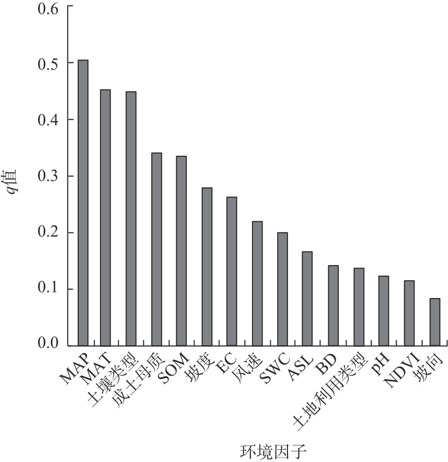
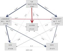
图6
不同环境因子对土壤粒径分形维数特征驱动作用结构方程模型(SEM) 注:红色和蓝色实箭头分别表示正向和负向影响;虚线表示不显著的路径;箭头旁的数字表示标准路径系数;箭头宽度与关联强度成正比。多层矩阵中,PC2向上箭头表示相邻变量与相应PC1之间的正向关系;向下箭头表示相邻变量与相应PC1之间的负向关系。*、**、***分别表示不同环境因子间显著(P<0.05)、极显著(P<0.01)、极其显著(P<0.001)。R2为决定系数,衡量模型对变量变异的解释能力;GOF为模型整体拟合优度的指标,GOF>0.4视为接受模型。"
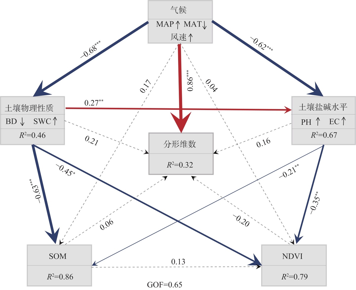
表8
不同环境因子与分形维数Pearson相关性分析"
| 驱动因子 | MAP | MAT | ASL | 坡度 | 坡向 | BD | SWC | SOM | pH | EC | NDVI | 风速 | 分形维数 |
|---|---|---|---|---|---|---|---|---|---|---|---|---|---|
| MAP | 1.00 | - | - | - | - | - | - | - | - | - | - | - | - |
| MAT | -0.68** | 1.00 | - | - | - | - | - | - | - | - | - | - | - |
| ASL | 0.20 | -0.73** | 1.00 | - | - | - | - | - | - | - | - | - | - |
| 坡度 | 0.45** | -0.60** | 0.58** | 1.00 | - | - | - | - | - | - | - | - | - |
| 坡向 | -0.19 | 0.66** | -0.019 | 0.033 | 1.00 | - | - | - | - | - | - | - | - |
| BD | -0.61** | 0.56** | -0.42** | -0.58** | 0.089 | 1.00 | - | - | - | - | - | - | - |
| SWC | 0.66** | -0.61** | 0.44** | -0.54** | -0.14 | -0.84** | 1.00 | - | - | - | - | - | - |
| SOM | 0.75** | -0.67** | 0.38** | -0.64** | -0.15 | -0.84** | 0.88** | 1.00 | - | - | - | - | - |
| pH | -0.79** | 0.59** | -0.21** | -0.47** | 0.012 | 0.71** | -0.70** | -0.79** | 1.00 | - | - | - | - |
| EC | -0.33* | -0.43** | -0.23 | -0.30* | 0.11 | 0.05 | -0.12 | -0.24 | 0.21 | 1.00 | - | - | - |
| NDVI | 0.75** | -0.61** | 0.31* | -0.57** | -0.029 | -0.81** | 0.79** | 0.84** | -0.81** | -0.22 | 1.00 | - | - |
| 风速 | 0.17 | -0.20 | -0.09 | -0.09 | 0.03 | 0.05 | 0.001 | 0.071 | -0.16 | -0.18 | -0.10 | 1.00 | - |
| 分形维数 | 0.42** | -0.45** | 0.12 | 0.16 | -0.10 | -0.12 | 0.16 | 0.24 | -0.26* | -0.10 | 0.16 | 0.29* | 1.00 |
| [1] | 徐加盼, 李继洪, 魏玉杰, 等. 不同母质类型发育土壤颗粒组成分形特征[J]. 土壤学报, 2020, 57(5): 1197-1205. |
| [Xu Jiapan, Li Jihong, Wei Yujie, et al. Fractal characteristics of particle composition for soils developed from different parent materials[J]. Acta Pedologica Sinica, 2020, 57(5): 1197-1205.] | |
| [2] |
张世文, 张立平, 袁君, 等. 基于分形理论和地质统计学的表层土壤颗粒大小分布变化特征[J]. 中国农业科学, 2014, 47(13): 2591-2601.
doi: 10.3864/j.issn.0578-1752.2014.13.011 |
| [Zhang Shiwen, Zhang Liping, Yuan Jun, et al. Characterizing variation of topsoil particle size distribution based on fractal theory and geostatistics[J]. Scientia Agricultura Sinica, 2014, 47(13): 2591-2601.] | |
| [3] |
Mandelbrot B. How long is the coast of Britain? Statistical self similarity and fractional dimension[J]. Science, 1967, 156(3775): 636-638.
pmid: 17837158 |
| [4] |
Tyler S W, Wheatcraft S W. Fractal scaling of soil particle-size distributions: Analysis and limitations[J]. Soil Science Society of America Journal, 1992, 56(2): 362-369.
doi: 10.2136/sssaj1992.03615995005600020005x |
| [5] | 贾重建, 卢瑛, 吴刚, 等. 广东罗浮山土壤颗粒分形维数分布特征[J]. 土壤通报, 2022, 53(5): 1049-1055. |
| [Jia Chongjian, Lu Ying, Wu Gang, et al. Fractal features of particle-size distribution of soil profiles in Luofu Mountain, Guangdong[J]. Chinese Journal of Soil Science, 2022, 53(5): 1049-1055.] | |
| [6] | 杜丹丹, 高瑞忠, 贾德彬. 吉兰泰盐湖盆地土壤颗粒分形特征与空间变异分析[J]. 水土保持研究, 2023, 30(6): 93-101. |
| [Du Dandan, Gao Ruizhong, Jia Debin. Analysis of fractal characteristics and spatial variability of soil particles in the Jilantai Salt Lake Basin[J]. Research of Soil and Water Conservation, 2023, 30(6): 93-101.] | |
| [7] | 吕圣桥, 高鹏, 耿广坡, 等. 黄河三角洲滩地土壤颗粒分形特征及其与土壤有机质的关系[J]. 水土保持学报, 2011, 25(6): 134-138. |
| [Lü Shengqiao, Gao Peng, Geng Guangpo, et al. Characteristics of soil particles and their correlation with soil organic matter in lowlands of the Yellow River Delta[J]. Journal of Soil and Water Conservation, 2011, 25(6): 134-138.] | |
| [8] |
黄业芸, 邱开阳, 朱亚超, 等. 贺兰山不同海拔植被生物量与土壤分形特征和土壤水分的相关关系[J]. 草业学报, 2023, 32(12): 24-35.
doi: 10.11686/cyxb2023050 |
|
[Huang Yeyun, Qiu Kaiyang, Zhu Yachao, et al. Correlation between vegetation biomass and soil fractal characteristics and soil moisture at different elevations in the Helan Mountains[J]. Acta Prataculturae Sinica, 2023, 32(12): 24-35.]
doi: 10.11686/cyxb2023050 |
|
| [9] | 赵守强, 迟大群, 贾付诚, 等. 不同地区盐渍土土壤颗粒的分形特征[J]. 江苏农业科学, 2021, 49(6): 203-207. |
| [Zhao Shouqiang, Chi Daqun, Jia Fucheng, et al. Fractal characteristics of soil particles in saline soils in different regions[J]. Jiangsu Agricultural Sciences, 2021, 49(6): 203-207.] | |
| [10] |
周雷, 曲潇琳, 周涛, 等. 宁夏土壤颗粒组成特点及其影响因素分析[J]. 中国农业科学, 2023, 56(21): 4272-4287.
doi: 10.3864/j.issn.0578-1752.2023.21.011 |
|
[Zhou Lei, Qu Xiaolin, Zhou Tao, et al. Analysis of the characteristics and influencing factors of soil particle composition in Ningxia[J]. Scientia Agricultura Sinica, 2023, 56(21): 4272-4287.]
doi: 10.3864/j.issn.0578-1752.2023.21.011 |
|
| [11] |
刘全渝, 李从娟, 李桂真. 添加膨润土对风蚀沙化土壤理化性质及植被生长的影响[J]. 干旱区研究, 2025, 42(3): 456-466.
doi: 10.13866/j.azr.2025.03.06 |
|
[Liu Quanyu, Li Congjuan, Li Guizhen. Effects of addition of the bentonite on the physicochemical properties and vegetation growth of wind-eroded sandy soil[J]. Arid Zone Research, 2025, 42(3): 456-466.]
doi: 10.13866/j.azr.2025.03.06 |
|
| [12] |
贺郝钰, 刘蔚, 常宗强, 等. 沙区生物土壤结皮演替对表层土壤养分和微生物群落组成的影响[J]. 干旱区地理, 2024, 47(10): 1724-1734.
doi: 10.12118/j.issn.1000-6060.2024.322 |
|
[He Haoyu, Liu Wei, Chang Zongqiang, et al. Effects of biological soil crust succession on soil nutrients, microbial community composition in desert regions[J]. Arid Land Geography, 2024, 47(10): 1724-1734.]
doi: 10.12118/j.issn.1000-6060.2024.322 |
|
| [13] | 王会静, 郭玉川, 白运保, 等. 新疆植被动态格局及其对气候的时滞效应[J]. 农业工程学报, 2023, 39(11): 137-145. |
| [Wang Huijing, Guo Yuchuan, Bai Yunbao, et al. Dynamic pattern of vegetation in Xinjiang and its time-lag effect on climate[J]. Transactions of the Chinese Society of Agricultural Engineering (Transactions of the CSAE), 2023, 39(11): 137-145.] | |
| [14] |
宋小龙, 李陇堂, 任婕, 等. 西北干旱生态地理区NDVI时空变化特征及其驱动力[J]. 干旱区地理, 2025, 48(6): 951-962.
doi: 10.12118/j.issn.1000-6060.2024.548 |
|
[Song Xiaolong, Li Longtang, Ren Jie, et al. Spatio-temporal variation characteristics and driving factors of NDVI in the arid and semi-arid region of northwest China[J]. Arid Land Geography, 2025, 48(6): 951-962.]
doi: 10.12118/j.issn.1000-6060.2024.548 |
|
| [15] | 刁二龙, 曹广超, 曹生奎, 等. 不同尺度下土壤粒径及分形特征[J]. 水土保持研究, 2024, 31(5): 212-220. |
| [Diao Erlong, Cao Guang-chao, Cao Shengkui, et al. Soil particle size and fractal characteristics at different scales[J]. Research of Soil and Water Conservation, 2024, 31(5): 212-220.] | |
| [16] | Udden J A. The mechanical composition of wind deposits[M]. Rock Island: Lutheran Augustana Book Concern, 1898: 1-69. |
| [17] | Krumbein W C. Size frequency distributions of sediments[J]. SEPM Journal of Sedimentary Research, 1934, 4(2): 65-77. |
| [18] | 张永成, 王洪辉, 谭桂花. 基于Excel VBA的图解粒度参数计算[J]. 成都理工大学学报(自然科学版), 2010, 37(6): 650-653. |
| [Zhang Yongcheng, Wang Honghui, Tan Guihua. Graphical calculation for grain size parameters by Excel VBA method[J]. Journal of Chengdu University of Technology (Science & Technology Edition), 2010, 37(6): 650-653.] | |
| [19] |
Folk R L, Ward W C. Brazos River bar: A study in the significance of grain size parameters[J]. Journal of Sedimentary Research, 1957, 27(1): 3-26.
doi: 10.1306/74D70646-2B21-11D7-8648000102C1865D |
| [20] |
罗玉红, 黄予姝, 珠娜, 等. 锡林郭勒盟典型草原区草地开垦及退耕造林对土壤粒径分布和养分的影响[J]. 中国农业科学, 2024, 57(24): 4919-4932.
doi: 10.3864/j.issn.0578-1752.2024.24.008 |
| [Luo Hongyu, Huang Yushu, Zhu Na, et al. Effects of cultivation and cropland afforestation on soil particle-size distribution and soil nutrients in the typical steppe of Xil-ingol League[J]. Scientia Agricultura Sinica, 2024, 57(24): 4919-4932.] | |
| [21] | 王国梁, 周生路, 赵其国. 土壤颗粒的体积分形维数及其在土地利用中的应用[J]. 土壤学报, 2005, 42(4): 545-550. |
| [Wang Guoliang, Zhou Shenglu, Zhao Qiguo. Volume fractal dimension of soil particles and its applications to land use[J]. Acta Pedologica Sinica, 2005, 42(4): 545-550.] | |
| [22] | 宛倩, 王杰, 王向涛, 等. 青藏高原不同草地利用方式对土壤粒径分形特征的影响[J]. 生态学报, 2022, 42(5): 1716-1726. |
| [Wan Qian, Wang Jie, Wang Xiangtao, et al. Effets of different meadow use types on the fractal characteristics of soil particle in the Qinghai-Xizang Plateau[J]. Acta Ecologica Sinica, 2022, 42(5): 1716-1726.] | |
| [23] |
Yan W, Angerer L, Birle E, et al. A graph-based approach for modeling the soil-water retention curve of granular soils across the entire suction range[J]. Acta Geotechnica, 2024, 19(8): 5545-5560.
doi: 10.1007/s11440-023-02166-y |
| [24] |
陈京平, 余子莹, 杨帆, 等. 塔克拉玛干沙漠腹地沙尘暴和地表沙物质粒度特征[J]. 中国沙漠, 2023, 43(2): 150-158.
doi: 10.7522/j.issn.1000-694X.2022.00112 |
|
[Chen Jingping, Yu Ziying, Yang Fan, et al. Particle size characteristics of sandstorm and surface sand at Tazhong area of Taklimakan Desert, China[J]. Journal of Desert Research, 2023, 43(2): 150-158.]
doi: 10.7522/j.issn.1000-694X.2022.00112 |
|
| [25] |
Mitchell P J, O’Grady A P, Pinkard E A, et al. An ecoclimatic framework for evaluating the resilience of vegetation to water deficit[J]. Global Change Biology, 2016, 22(5): 1677-1689.
doi: 10.1111/gcb.13177 pmid: 26643922 |
| [26] | 刘云鹏, 王国栋, 张社奇, 等. 陕西4种土壤粒径分布的分形特征研究[J]. 西北农林科技大学学报(自然科学版), 2003, 31(2): 92-94. |
| [Liu Yunpeng, Wang Guodong, Zhang Sheqi, et al. Fractal characteristics of particle-size distribution for four kinds of soil sa-mples in Shaanxi[J]. Journal of Northwest A & F University (Natural Science Edition), 2003, 31(2): 92-94.] | |
| [27] | 杨培岭, 罗远培, 石元春. 用粒径的重量分布表征的土壤分形特征[J]. 科学通报, 1993, 38(20): 1896-1899. |
| [Yang Peiling, Luo Yuanpei, Shi Yuanchun. The fractal characteristics of soil characterized by the weight distribution of particle size[J]. Chinese Science Bulletin, 1993, 38(20): 1896-1899.] | |
| [28] | 杨娟, 高永, 王瑞东, 等. 沙质草原风蚀坑土壤粒度组成及养分特征[J]. 中国农业科技导报, 2024, 26(10): 186-194. |
| [Yang Juan, Gao Yong, Wang Ruidong, et al. Soil particle composition and nutrient characteristics of wind erosion pits in sandy grassland[J]. Journal of Agricultural Science and Technology, 2024, 26(10): 186-194.] | |
| [29] |
刘茜雅, 王海兵, 左合君, 等. 苏宏图戈壁沉积物分形空间变异性及其成因[J]. 干旱区地理, 2021, 44(1): 168-177.
doi: 10.12118/j.issn.1000–6060.2021.01.18 |
|
[Liu Xiya, Wang Haibing, Zuo Hejun, et al. Fractal spatial variability and its genesis of sediments in Suhongtu gobi[J]. Arid Land Geography, 2021, 44(1): 168-177.]
doi: 10.12118/j.issn.1000–6060.2021.01.18 |
|
| [30] | 段晓明, 夏栋, 马悦阳, 等. 不同生态修复方式对土壤团聚体稳定性及胶结物质的影响[J]. 生态学报, 2025, 45(11): 5178-5190. |
| [Duan Xiaoming, Xia Dong, Ma Yueyang, et al. Effect of different restoration approaches of engineering disturbance slopes on bonding materials and stability of soil aggregate[J]. Acta Ecologica Sinica, 2025, 45(11): 5178-5190.] | |
| [31] |
杜雅仙, 樊瑾, 李诗瑶, 等. 荒漠草原不同植被微斑块土壤粒径分布分形特征与养分的关系[J]. 应用生态学报, 2019, 30(11): 3716-3724.
doi: 10.13287/j.1001-9332.201911.004 |
|
[Du Yaxian, Fan Jin, Li Shiyao, et al. Fractal dimension characteristics of soil particle size distribution under different vegetation patches in desert steppe and its relationship with soil nutrients[J]. Chinese Journal of Applied Ecology, 2019, 30(11): 3716-3724.]
doi: 10.13287/j.1001-9332.201911.004 |
|
| [32] |
Delgado-Baquerizo M, Maestre F T, Gallardo A, et al. Decoupling of soil nutrient cycles as a function of aridity in global drylands[J]. Nature, 2013, 502(7473): 672-676.
doi: 10.1038/nature12670 |
| [33] |
郭玉琳, 赵勇, 周雅蔓, 等. 新疆天山山区夏季降水日变化特征及其与海拔高度关系[J]. 干旱区地理, 2022, 45(1): 57-65.
doi: 10.12118/j.issn.1000–6060.2021.057 |
|
[Guo Yulin, Zhao Yong, Zhou Yaman, et al. Diurnal variation of summer precipitation and its relationship with altitude in Tianshan Mountains of Xinjiang[J]. Arid Land Geography, 2022, 45(1): 57-65.]
doi: 10.12118/j.issn.1000–6060.2021.057 |
|
| [34] | Certini G, Scalenghe R. The crucial interactions between climate and soil[J]. Science of the Total Environment, 2023, 856(2): 159-169. |
| [1] | 朱怡婷, 梁桂仙, 周春山, 辛龙, 李金雪. 新疆文旅新质生产力发展时空演变特征与驱动因素[J]. 干旱区地理, 2026, 49(1): 128-139. |
| [2] | 阿力木·艾尔肯, 李如琦, 努尔扎提·阿卜杜柯尤木, 玛依热·艾海提, 希热娜依·铁里瓦尔地. 1961—2022年新疆南部降雨和极端降雨特征[J]. 干旱区地理, 2026, 49(1): 13-22. |
| [3] | 杨迪, 邹进, 马晓飞, 张珣, 周锐, 刘艳春, 石金莲. 体育旅游资源空间分布特征及可持续发展研究——以新疆为例[J]. 干旱区地理, 2026, 49(1): 140-150. |
| [4] | 张飞, 李建, 李慧融, 谢涛, 张雪红, 王超, 白淑英, 宋正姗. 2001—2024年锡林郭勒盟草原净初级生产力时空特征及对影响因子的响应[J]. 干旱区地理, 2025, 48(9): 1555-1566. |
| [5] | 李亮亮, 夏咏, 王福红, 郭冰心, 赵兰兰. 新疆甜瓜生产格局及其贡献因素分析[J]. 干旱区地理, 2025, 48(9): 1567-1577. |
| [6] | 芮东升, 毛璐, 任艳霞, 贡浩轩, 李延萍, 付志聪. 新疆相对贫困空间分布特征及障碍因素分析[J]. 干旱区地理, 2025, 48(9): 1672-1682. |
| [7] | 王鑫, 郑芳, 何铃瑶, 何浩亮, 侯迎. 宁夏县域共同富裕水平时空分异格局及驱动因素研究[J]. 干旱区地理, 2025, 48(7): 1293-1303. |
| [8] | 王佩佩, 王娇, 蔡咏梅. 多尺度视域下中国滑雪场空间分异格局及其驱动因素研究[J]. 干旱区地理, 2025, 48(6): 1080-1088. |
| [9] | 刘海军, 张海虹, 闫俊杰, 李想, 李高峰. 新疆农业碳排放效率时空异质性及其影响因素[J]. 干旱区地理, 2025, 48(5): 866-878. |
| [10] | 李松芮, 林秋平, 杨上广. 新疆物流企业空间布局多尺度演化特征及影响因素研究[J]. 干旱区地理, 2025, 48(4): 739-752. |
| [11] | 王福红, 夏咏. 干旱区主要农作物生产时空格局演化及影响因素分析——以新疆地区为例[J]. 干旱区地理, 2025, 48(3): 444-454. |
| [12] | 李梦园, 庞家朋, 李欢. 省域典型旅游集散地综合可达性协调发展及空间关系研究——以新疆为例[J]. 干旱区地理, 2025, 48(3): 539-548. |
| [13] | 贾妮娅·叶力肯, 侯建楠, 刘思博. 近30 a新疆地州市旅游气候舒适度时空特征分析[J]. 干旱区地理, 2025, 48(2): 212-222. |
| [14] | 郭佳丽, 杜宏茹. 多元流视角下新疆绿洲城市网络格局研究[J]. 干旱区地理, 2025, 48(2): 323-332. |
| [15] | 牛飞飞, 郭靖, 罗杰, 勾雪平, 刘雪薇, 张仁平. 基于GeoSOS-FLUS和InVEST模型的新疆地区土地利用变化模拟及碳储量预测[J]. 干旱区地理, 2025, 48(12): 2169-2182. |
|
||