干旱区地理 ›› 2025, Vol. 48 ›› Issue (7): 1279-1292.doi: 10.12118/j.issn.1000-6060.2024.501 cstr: 32274.14.ALG2024501
武志平1( ), 姜民1, 付建新2,3,4()
收稿日期:2024-08-20
修回日期:2024-10-24
出版日期:2025-07-25
发布日期:2025-07-04
通讯作者:
付建新(1980-),男,博士,副教授,硕士生导师,主要从事土地利用、区域发展与国土空间规划研究. E-mail: fujx@163.com作者简介:武志平(2000-),女,硕士研究生,主要从事城市地理与城乡规划相关方面的研究. E-mail: Wuzhiping157@163.com
基金资助:
WU Zhiping1(), JIANG Min1, FU Jianxin2,3,4()
Received:2024-08-20
Revised:2024-10-24
Published:2025-07-25
Online:2025-07-04
摘要: 推进黄河“几”字弯都市圈城镇化高质量发展是打造黄河流域增长极的重要支撑。以黄河“几”字弯都市圈15个地级市为研究对象,从人口、经济、社会和生态4个维度构建城镇化高质量发展评价指标体系,运用熵值法、泰尔指数、标准差椭圆和地理探测器研究方法,分析了2012—2021年城镇化高质量发展时空分异特征及其驱动力。结果表明:(1) 从时间上看,2012—2021年黄河“几”字弯都市圈城镇化高质量发展水平整体呈波动上升趋势。(2) 从空间上看,黄河“几”字弯都市圈城镇化高质量发展水平空间差异显著,呈现“核心-边缘”的空间分布格局;城镇化高质量发展水平的总体差异呈现先上升后下降的趋势,区域内差异是城镇化高质量发展总体差异的主要来源;标准差椭圆空间分布方向整体呈“东北—西南”走向,椭圆重心在鄂尔多斯市境内,空间集聚特征明显。(3) 经济基础是城镇化高质量发展的主导因素,市场环境、政府调控能力和科技创新能力对城镇化高质量发展起到重要作用。研究结果可为黄河“几”字弯都市圈城镇化高质量发展和区域协调发展提供一定的理论支持和参考依据。
武志平, 姜民, 付建新. 黄河“几”字弯都市圈城镇化高质量发展时空分异及驱动力[J]. 干旱区地理, 2025, 48(7): 1279-1292.
WU Zhiping, JIANG Min, FU Jianxin. Spatial and temporal differences and driving forces for high-quality development of urbanization in the Jiziwan metropolitan area of the Yellow River[J]. Arid Land Geography, 2025, 48(7): 1279-1292.
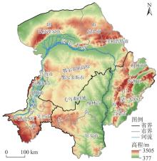
图1
黄河“几”字弯都市圈示意图 注:基于自然资源部标准地图服务网站审图号为GS(2020)4619号的标准地图制作,底图边界无修改。下同。"
表1
黄河“几”字弯都市圈城镇化高质量发展评价指标体系及权重"
| 维度 | 指标 | 单位 | 属性 | 权重 |
|---|---|---|---|---|
| 人口城镇化 | 人口密度 | 人·km-2 | 正向 | 0.0525 |
| 城镇人口占比 | % | 正向 | 0.0345 | |
| 城镇登记失业率 | % | 负向 | 0.0251 | |
| 经济城镇化 | 人均GDP | 104元 | 正向 | 0.0748 |
| 一般公共预算收入 | 104元 | 正向 | 0.1004 | |
| 社会消费品零售总额 | 104元 | 正向 | 0.1148 | |
| 第二产业占GDP比重 | % | 正向 | 0.0336 | |
| 第三产业占GDP比重 | % | 正向 | 0.0347 | |
| 规模以上工业企业个数 | 个 | 正向 | 0.0598 | |
| 社会城镇化 | 人均道路面积 | m2 | 正向 | 0.0485 |
| 城市供水普及率 | % | 正向 | 0.0038 | |
| 城市燃气普及率 | % | 正向 | 0.0067 | |
| 每万人普通中学在校学生数 | 人 | 正向 | 0.0189 | |
| 公共图书馆图书藏量 | 103册 | 正向 | 0.1737 | |
| 每万人拥有医疗床位数 | 张 | 正向 | 0.0352 | |
| 生态城镇化 | 人均公园绿地面积 | m2 | 正向 | 0.0446 |
| 建成区绿化覆盖率 | % | 正向 | 0.0064 | |
| 城市污水处理率 | % | 正向 | 0.0065 | |
| 生活垃圾无害化处理率 | % | 正向 | 0.0053 | |
| 道路清扫保洁面积 | 104 m2 | 正向 | 0.1202 |
图2
2012—2021年黄河“几”字弯都市圈城镇化高质量发展综合指数均值"
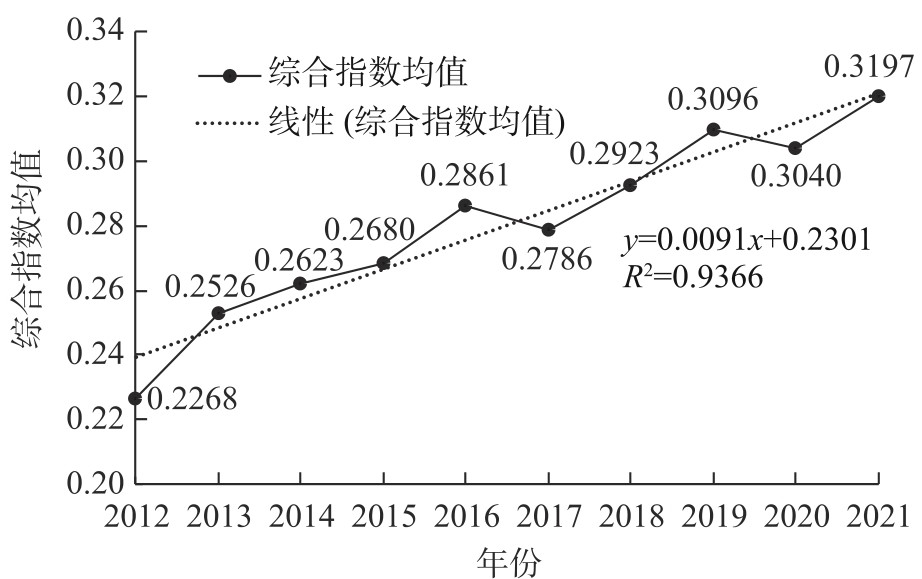
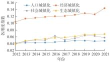
图3
2012—2021年黄河“几”字弯都市圈城镇化高质量发展各维度指数变化"
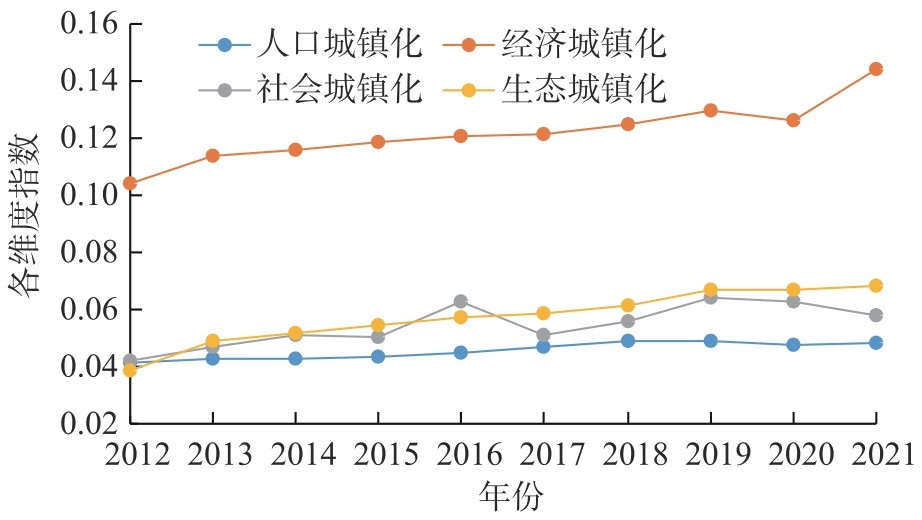
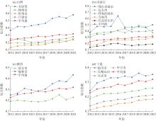
图4
2012—2021年黄河“几”字弯都市圈各城市城镇化高质量发展综合指数变化"

表2
2012—2021年黄河“几”字弯都市圈各城市城镇化高质量发展各维度指数均值"
| 城市 | 人口城镇化指数 | 经济城镇化指数 | 社会城镇化指数 | 生态城镇化指数 | |||||||
|---|---|---|---|---|---|---|---|---|---|---|---|
| 均值 | 排序 | 均值 | 排序 | 均值 | 排序 | 均值 | 排序 | ||||
| 太原市 | 0.0564 | 4 | 0.2261 | 1 | 0.0847 | 2 | 0.1076 | 2 | |||
| 朔州市 | 0.0416 | 9 | 0.0860 | 9 | 0.0465 | 10 | 0.0314 | 12 | |||
| 忻州市 | 0.0271 | 14 | 0.0836 | 10 | 0.0414 | 13 | 0.0286 | 13 | |||
| 吕梁市 | 0.0608 | 3 | 0.1180 | 7 | 0.0353 | 15 | 0.0241 | 14 | |||
| 呼和浩特市 | 0.0648 | 2 | 0.1769 | 5 | 0.0496 | 6 | 0.0901 | 4 | |||
| 包头市 | 0.0432 | 8 | 0.2003 | 3 | 0.0743 | 3 | 0.0835 | 5 | |||
| 乌海市 | 0.0707 | 1 | 0.0822 | 11 | 0.0449 | 11 | 0.0480 | 7 | |||
| 鄂尔多斯市 | 0.0507 | 6 | 0.2246 | 2 | 0.0954 | 1 | 0.1087 | 1 | |||
| 巴彦淖尔市 | 0.0341 | 12 | 0.0628 | 13 | 0.0448 | 12 | 0.0354 | 11 | |||
| 延安市 | 0.0532 | 5 | 0.0902 | 8 | 0.0402 | 14 | 0.0224 | 15 | |||
| 榆林市 | 0.0385 | 10 | 0.1900 | 4 | 0.0495 | 7 | 0.0463 | 8 | |||
| 银川市 | 0.0377 | 11 | 0.1295 | 6 | 0.0627 | 4 | 0.0944 | 3 | |||
| 石嘴山市 | 0.0483 | 7 | 0.0660 | 12 | 0.0554 | 5 | 0.0591 | 6 | |||
| 吴忠市 | 0.0339 | 13 | 0.0567 | 14 | 0.0494 | 8 | 0.0410 | 10 | |||
| 中卫市 | 0.0243 | 15 | 0.0369 | 15 | 0.0476 | 9 | 0.0428 | 9 | |||
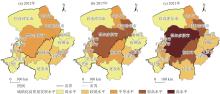
图5
黄河“几”字弯都市圈城镇化高质量发展空间分布"

表3
2012—2021年黄河“几”字弯都市圈城镇化高质量发展的泰尔指数及其贡献率"
| 年份 | 泰尔指数 | 组内差距 | 组间差距 | 贡献率/% | |
|---|---|---|---|---|---|
| 组内 | 组间 | ||||
| 2012 | 0.06848 | 0.05338 | 0.01511 | 77.94 | 22.06 |
| 2013 | 0.07927 | 0.06420 | 0.01507 | 80.99 | 19.01 |
| 2014 | 0.06872 | 0.05545 | 0.01327 | 80.69 | 19.31 |
| 2015 | 0.07366 | 0.05549 | 0.01817 | 75.33 | 24.67 |
| 2016 | 0.09584 | 0.06658 | 0.02926 | 69.47 | 30.53 |
| 2017 | 0.07087 | 0.05673 | 0.01414 | 80.05 | 19.95 |
| 2018 | 0.07044 | 0.05986 | 0.01059 | 84.97 | 15.03 |
| 2019 | 0.07036 | 0.06010 | 0.01026 | 85.42 | 14.58 |
| 2020 | 0.06409 | 0.05456 | 0.00953 | 85.13 | 14.87 |
| 2021 | 0.06176 | 0.05290 | 0.00886 | 85.65 | 14.35 |
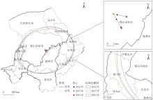
图6
黄河“几”字弯都市圈城镇化高质量发展方向分布及重心变化"
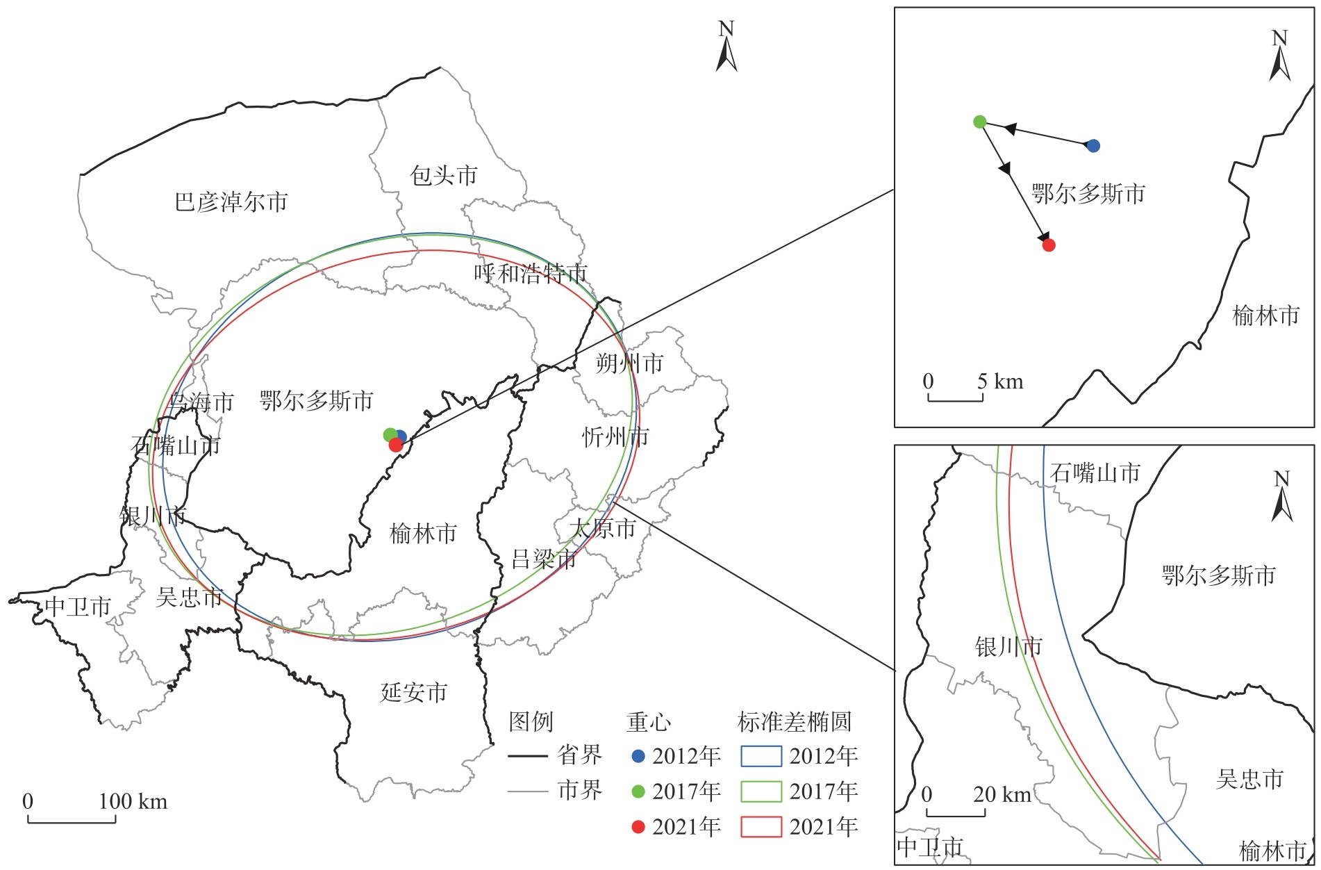
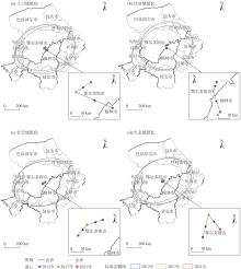
图7
黄河“几”字弯都市圈城镇化高质量发展各维度方向分布及重心变化"
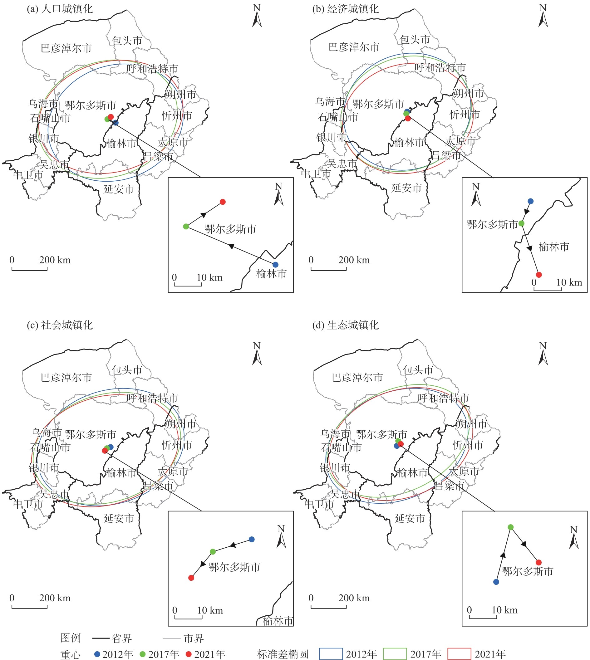
表4
黄河“几”字弯都市圈城镇化高质发展的影响因素指标体系"
| 维度 | 指标 | 单位 |
|---|---|---|
| 经济基础 | 地区生产总值(X1) | 104元 |
| 金融机构贷款余额(X2) | 104元 | |
| 政府调控能力 | 地方一般公共预算收入(X3) | 104元 |
| 市场环境 | 社会消费品零售总额(X4) | 104元 |
| 人力资本 | 每万人在校中学生数(X5) | 人 |
| 产业结构 | 第二、三产业占GDP比重(X6) | % |
| 科技创新能力 | 教育、科学技术支出(X7) | 104元 |
| 对外开放程度 | 进出口总额(X8) | 104 USD |
表5
黄河“几”字弯都市圈城镇化高质量发展空间分异影响因子探测结果"
| 影响因子 | q值 | ||
|---|---|---|---|
| 2012年 | 2017年 | 2021年 | |
| X1 | 0.861585*** | 0.784366** | 0.853240*** |
| X2 | 0.749393 | 0.906126*** | 0.889410*** |
| X3 | 0.856192** | 0.725715** | 0.763970** |
| X4 | 0.841920** | 0.890529*** | 0.885348** |
| X5 | 0.131173 | 0.308228 | 0.696286** |
| X6 | 0.717791 | 0.609594 | 0.513431 |
| X7 | 0.435654 | 0.484844 | 0.739060** |
| X8 | 0.498088 | 0.342002 | 0.496852 |

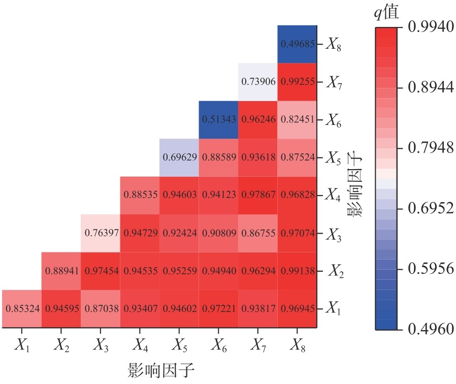
图8
2021年黄河“几”字弯都市圈城镇化高质量发展影响因子交互探测结果 注:X1~X8含义见表4;q值为影响因子对城镇化高质量发展的解释力。"
| [1] | 任保平, 巩羽浩. 黄河流域城镇化与高质量发展的耦合研究[J]. 经济问题, 2022(3): 1-12. |
| [ Ren Baoping, Gong Yuhao. Study on the coupling of urbanization and high-quality development in the Yellow River Basin[J]. On Economic Problems, 2022(3): 1-12. ] | |
| [2] | 方创琳. 中国新型城镇化高质量发展的规律性与重点方向[J]. 地理研究, 2019, 38(1): 13-22. |
| [ Fang Chuanglin. Basic rules and key paths for high-quality development of the new urbanization in China[J]. Geographical Research, 2019, 38(1): 13-22. ] | |
| [3] | 刘秉镰, 孙鹏博. 新发展格局下中国城市高质量发展的重大问题展望[J]. 西安交通大学学报(社会科学版), 2021, 41(3): 1-8. |
| [ Liu Binglian, Sun Pengbo. Prospects for major issues of high-quality development of Chinese cities under the new development pattern, influencing factors[J]. Journal of Xi’an Jiaotong University (Social Sciences Edition), 2021, 41(3): 1-8. ] | |
| [4] | 方创琳, 赵文杰. 新型城镇化及城乡融合发展促进中国式现代化建设[J]. 经济地理, 2023, 43(1): 10-16. |
| [ Fang Chuanglin, Zhao Wenjie. Facilitating Chinese path to modernization through new-type urbanization and integrated urban-rural development[J]. Economic Geography, 2023, 43(1): 10-16. ] | |
| [5] | 王滨. 城镇化高质量发展测度及其时空差异研究[J]. 统计与决策, 2019, 35(22): 46-50. |
| [ Wang Bin. Measurement and spatial-temporal differences of high-quality urbanization development[J]. Statistics & Decision, 2019, 35(22): 46-50. ] | |
| [6] | 熊曦, 段宜嘉, 傅为一, 等. 长江中游城市群城镇化效率评价及时空分异[J]. 经济地理, 2021, 41(3): 105-112. |
| [ Xiong Xi, Duan Yijia, Fu Weiyi, et al. Evaluation of urbanization efficiency of urban agglomeration in the middle reaches of Yangtze River and its spatio-temporal differentiation characteristic[J]. Economic Geography, 2021, 41(3): 105-112. ] | |
| [7] | 姜炎鹏, 于晓阳, 林栋. 竞争型城镇化水平测度、空间分异及其影响因素[J]. 经济地理, 2024, 44(7): 22-32. |
| [ Jiang Yanpeng, Yu Xiaoyang, Lin Dong. Level measurement, spatial differentiation and influencing factors of competitive urbanization in China[J]. Economic Geography, 2024, 44(7): 22-32. ] | |
| [8] | 蒋正云, 胡艳. 中国新型城镇化高质量发展时空格局及异质性演化分析[J]. 城市问题, 2021(3): 4-16. |
| [ Jiang Zhengyun, Hu Yan. Analysis of the spatial and temporal patterns and heterogeneity of high-quality development of China’s new urbanization[J]. Urban Problems, 2021(3): 4-16. ] | |
| [9] | 杜宏茹, 唐钰婷, 张紫芸. 新疆干旱区城镇化的地域特征及其高质量发展路径[J]. 经济地理, 2021, 41(10): 200-206. |
| [ Du Hongru, Tang Yuting, Zhang Ziyun. Regional characteristics and high-quality development path of urbanization in arid region of Xinjiang[J]. Economic Geography, 2021, 41(10): 200-206. ] | |
| [10] | 申庆喜, 李诚固, 胡述聚, 等. 东北地区城镇化质量测度及其时空格局特征[J]. 地理科学, 2021, 41(11): 2002-2010. |
| [ Shen Qingxi, Li Chenggu, Hu Shuju, et al. Measurement and spatio-temporal patterns of urbanization quality in northeast China[J]. Scientia Geographica Sinica, 2021, 41(11): 2002-2010. ] | |
| [11] | 欧进锋, 许抄军, 陈东. 广东省新型城镇化高质量发展水平演变及其影响因素[J]. 经济地理, 2023, 43(3): 78-87. |
| [ Ou Jinfeng, Xu Chaojun, Chen Dong. High-quality development of new urbanization in Guangdong Province: Spatio-temporal evolution, influencing factors[J]. Economic Geography, 2023, 43(3): 78-87. ] | |
| [12] | 杨佩卿. 中国式现代化场阈数字经济赋能新型城镇化研究[J]. 西北大学学报(哲学社会科学版), 2023, 53(4): 168-182. |
| [ Yang Peiqing. Study on new-style urbanization enabled by digital economy at the threshold of Chinese modernization field[J]. Journal of Northwest University (Philosophy and Social Sciences Edition), 2023, 53(4): 168-182. ] | |
| [13] | 韩冬. 城镇化高质量发展水平测度——基于京津冀城市群的实证[J]. 统计与决策, 2022, 38(4): 93-97. |
| [ Han Dong. Measuring the high quality development level of urbanisation: Empirical evidence based on the Beijing-Tianjin-Hebei City cluster[J]. Statistics & Decision, 2022, 38(4): 93-97. ] | |
| [14] | 杨阳, 唐晓岚. 长江流域新型城镇化耦合协调度时空分异与空间集聚[J]. 长江流域资源与环境, 2022, 31(3): 503-514. |
| [ Yang Yang, Tang Xiaolan. Spatial-temporal differentiation and spatial agglomeration of new urbanization coupling coordination degree in Yangtze Basin[J]. Resources and Environment in the Yangtze Basin, 2022, 31(3): 503-514. ] | |
| [15] | 田明, 田一聪, 曾丹. 青藏高原县域城镇化多维协调时空演变及其机制[J]. 地理学报, 2024, 79(8): 1940-1960. |
| [ Tian Ming, Tian Yicong, Zeng Dan. Spatiotemporal evolution and mechanism of multidimensional coordinated county urbanization on the Qinghai-Tibet Plateau[J]. Acta Geographica Sinica, 2024, 79(8): 1940-1960. ] | |
| [16] | 魏超, 吴洲, 李荣娟, 等. 湖北省县城城镇化质量测度及协调发展研究[J]. 经济地理, 2023, 43(6): 95-105. |
| [ Wei Chao, Wu Zhou, Li Rongjuan, et al. Urbanization quality measurement and its coordinated development in counties of Hubei Province[J]. Economic Geography, 2023, 43(6): 95-105. ] | |
| [17] | 瞿诗进, 马珺, 李全峰, 等. 长江中游地区县城城镇化质量演变规律与驱动机制[J]. 经济地理, 2023, 43(2): 93-102. |
| [ Qu Shijin, Ma Jun, Li Quanfeng, et al. Pattern evolution and driving mechanism of urbanization quality at county level in the middle reaches of Yangtze River[J]. Economic Geography, 2023, 43(2): 93-102. ] | |
| [18] | 方创琳. 新发展格局下的中国城市群与都市圈建设[J]. 经济地理, 2021, 41(4): 1-7. |
| [ Fang Chuanglin. China’s urban agglomeration and metropolitan area construction under the new development pattern[J]. Economic Geography, 2021, 41(4): 1-7. ] | |
| [19] | 安树伟, 张双悦. 黄河“几”字弯区域高质量发展研究[J]. 山西大学学报(哲学社会科学版), 2021, 44(2): 134-144. |
| [ An Shuwei, Zhang Shuangyue. On the high-quality development of the bend area of the Yellow River[J]. Journal of Shanxi University (Philosophy and Social Science Edition), 2021, 44(2): 134-144. ] | |
| [20] | 邹亚锋, 张倩, 饶钰飞, 等. 中国西部省会城市新型城镇化发展水平演化研究[J]. 干旱区地理, 2023, 46(4): 636-648. |
| [ Zou Yafeng, Zhang Qian, Rao Yufei, et al. Evolution of new urbanization of provincial capitals in western China[J]. Arid Land Geography, 2023, 46(4): 636-648. ] | |
| [21] | 刘苗苗, 吴卫东. 陕西省新型城镇化与乡村振兴耦合性实证研究[J]. 干旱区地理, 2024, 47(8): 1420-1430. |
| [ Liu Miaomiao, Wu Weidong. Empirical study of the coupling of new urbanization and rural revitalization in Shaanxi Province[J]. Arid Land Geography, 2024, 47(8): 1420-1430. ] | |
| [22] | 徐雪. 新型城镇化高质量发展的多维测度、空间差异及动态演进[J]. 统计与决策, 2024, 40(10): 100-105. |
| [ Xu Xue. Multidimensional measurement, spatial differences and dynamic evolution of high-quality development of new-type urbanization[J]. Statistics & Decision, 2024, 40(10): 100-105. ] | |
| [23] | 张春梅, 张小林, 吴启焰, 等. 发达地区城镇化质量的测度及其提升对策——以江苏省为例[J]. 经济地理, 2012, 32(7): 50-55. |
| [ Zhang Chunmei, Zhang Xiaolin, Wu Qiyan, et al. Measures and improvement of urbanization development quality in the developed area: A case study of Jiangsu[J]. Economic Geography, 2012, 32(7): 50-55. ] | |
| [24] | 陈明星, 陆大道, 张华. 中国城市化水平的综合测度及其动力因子分析[J]. 地理学报, 2009, 64(4): 387-398. |
| [ Chen Mingxing, Lu Dadao, Zhang Hua. Comprehensive evaluation and the driving factors of China’s urbanization[J]. Acta Geographica Sinica, 2009, 64(4): 387-398. ] | |
| [25] | 李汝资, 黄晓玲, 刘耀彬. 2010—2020年中国城镇化的时空分异及影响因素[J]. 地理学报, 2023, 78(4): 777-791. |
| [ Li Ruzi, Huang Xiaoling, Liu Yaobin. Spatio-temporal differentiation and influencing factors of China’s urbanization from 2010 to 2020[J]. Acta Geographica Sinica, 2023, 78(4): 777-791. ] | |
| [26] | 郭力娜, 訾丰娇, 王刚, 等. 基于发展和环境的城镇化质量时空特征与影响因子探测分析——以辽宁省为例[J]. 南京信息工程大学学报(自然科学版), 2023, 15(2): 127-136. |
| [ Guo Lina, Zi Fengjiao, Wang Gang, et al. Spatiotemporal characteristics and influencing factors of urbanization quality based on development and environment: Taking Liaoning Province as an example[J]. Journal of Nanjing University of Information Science & Technology, 2023, 15(2): 127-136. ] | |
| [27] | 王劲峰, 徐成东. 地理探测器: 原理与展望[J]. 地理学报, 2017, 72(1): 116-134. |
| [ Wang Jinfeng, Xu Chengdong. Geodetector: Principle and prospective[J]. Acta Geographica Sinica, 2017, 72(1): 116-134. ] | |
| [28] | 方创琳. 黄河流域城市群形成发育的空间组织格局与高质量发展[J]. 经济地理, 2020, 40(6): 1-8. |
| [ Fang Chuanglin. Spatial organization pattern and high-quality development of urban agglomeration in the Yellow River Basin[J]. Economic Geography, 2020, 40(6): 1-8. ] | |
| [29] | 朱肖勇, 付占辉, 乔家君, 等. 黄河流域城镇人口和用地变化的关联格局及地域类型[J]. 西北大学学报(自然科学版), 2024, 54(3): 450-460. |
| [ Zhu Xiaoyong, Fu Zhanhui, Qiao Jiajun, et al. The correlation pattern and regional types of urban population and land use changes in the Yellow River Basin[J]. Journal of Northwest University (Natural Science Edition), 2024, 54(3): 450-460. ] | |
| [30] | 金凯, 王飞, 韩剑桥, 等. 1982—2015年中国气候变化和人类活动对植被NDVI变化的影响[J]. 地理学报, 2020, 75(5): 961-974. |
| [ Jin Kai, Wang Fei, Han Jianqiao, et al. Contribution of climatic change and human activities to vegetation NDVI change over China during 1982—2015[J]. Acta Geographica Sinica, 2020, 75(5): 961-974. ] | |
| [31] | 赵田, 刘兆德, 郭树明, 等. 黄河流域城镇化水平的时空特征及影响因素研究[J]. 陕西理工大学学报(自然科学版), 2021, 37(3): 82-89. |
| [ Zhao Tian, Liu Zhaode, Guo Shuming, et al. Research on the spatial-temporal characteristics and influencing factors of urbanization in the Yellow River Basin[J]. Journal of Shaanxi University of Technology (Natural Science Edition), 2021, 37(3): 82-89. ] | |
| [32] | 曾冰, 谢琦. 基于夜间灯光数据的黄河流域经济发展空间特征与影响机制分析[J]. 中国沙漠, 2022, 42(3): 41-50. |
| [ Zeng Bing, Xie Qi. Spatial characteristics and impact mechanism of economic development indicated by night lighting data in the Yellow River Basin[J]. Journal of Desert Research, 2022, 42(3): 41-50. ] | |
| [33] | 宋劲松, 袁梦伊, 张丽娜. 新型城镇化影响区域高质量发展的空间效应——以长江中游城市群为例[J]. 经济地理, 2024, 44(11): 43-51. |
| [ Song Jingsong, Yuan Mengyi, Zhang Lina. Spatial effects of new-type urbanization affecting regional high-quality development: A case study of urban agglomerations in the middle reaches of the Yangtze River[J]. Economic Geography, 2024, 44(11): 43-51. ] | |
| [34] | 孙崇明, 叶继红. “等级制”下的城镇化治理风险与改革路径——基于“反梯度理论”的探讨[J]. 学习与实践, 2018(9): 60-67. |
| [ Sun Chongming, Ye Jihong. Governance risks and reform paths of urbanization under the ‘hierarchical system’: A discussion based on the ‘inverse gradient theory’[J]. Study and Practice, 2018(9): 60-67. ] | |
| [35] | 余杰, 钱振明. 面向中国式现代化的城市高质量发展: 五大维度和三重尺度下的实践向度[J]. 当代经济管理, 2024, 46(3): 1-13. |
| [ Yu Jie, Qian Zhenming. High-quality urban development towards Chinese-style modernization: Practical orientations based on five dimensions and triple scales[J]. Contemporary Economic Management, 2024, 46(3): 1-13. ] | |
| [36] | 邓万行. 优化公平竞争市场环境打造高质量发展强磁场[N]. 鹤壁日报, 2024-05-31( 01). |
| [ Deng Wanxing. Optimising a fair and competitive market environment to create a strong magnetic field for high quality development[N]. Hebi Daily News, 2024-05-31( 01). ] | |
| [37] | 徐振宇, 李人庆. 从“小城镇大问题”到“小城市大问题”——“中国第一农民城”龙港的追踪调查[J]. 清华大学学报(哲学社会科学版), 2020, 35(5): 80-96, 204. |
| [ Xu Zhenyu, Li Renqing. From small towns with big problems to small cities with big problems: Follow-up survey on Longgang (the first peasant city in China)[J]. Journal of Tsinghua University (Philosophy and Social Sciences Edition), 2020, 35(5): 80-96, 204. ] | |
| [38] | 田佳, 李柳, 徐坤, 等. 科技创新对经济高质量发展的影响研究——以京津冀城市群为例[J]. 统计与管理, 2023, 38(1): 4-15. |
| [ Tian Jia, Li Liu, Xu Kun, et al. Research on the impact of science and technology innovation on the high quality development of economy: Taking Beijing-Tianjin-Hebei City cluster as an example[J]. Statistics and Management, 2023, 38(1): 4-15. ] | |
| [39] | 钟茂初, 赵天爽. 京津冀中心城市科技创新对城市群高质量发展的影响[J]. 河北经贸大学学报, 2024, 45(3): 53-63. |
| [ Zhong Maochu, Zhao Tianshuang. The impact of scientific and technological innovation in the central cities of Beijing-Tianjin-Hebei region on the high-quality development of urban agglomeration[J]. Journal of Hebei University of Economics and Business, 2024, 45(3): 53-63. ] | |
| [40] | 方创琳, 张国友, 薛德升. 中国城市群高质量发展与科技协同创新共同体建设[J]. 地理学报, 2021, 76(12): 2898-2908. |
| [ Fang Chuanglin, Zhang Guoyou, Xue Desheng. High-quality development of urban agglomerations in China and construction of science and technology collaborative innovation community[J]. Acta Geographica Sinica, 2021, 76(12): 2898-2908. ] | |
| [41] | 郭文炯. “资源诅咒”的空间结构解析: 核心边缘理论视角[J]. 经济地理, 2014, 34(3): 17-23. |
| [ Guo Wenjiong. Analysis of the spatial structure of “resource curse”: Based on the core-periphery theory[J]. Economic Geography, 2014, 34(3): 17-23. ] | |
| [42] | 孔祥利, 王艳. 空间正义视域下县域城镇化高质量发展的理论逻辑与实践进路[J]. 贵州师范大学学报(社会科学版), 2025(1): 89-99. |
| [ Kong Xiangli, Wang Yan. The theoretical logic and practical approach in high-quality development of county urbanization from the perspective of spatial justice[J]. Journal of Guizhou Normal University (Social Sciences Edition), 2025(1): 89-99. ] | |
| [43] | 孙久文, 周孝伦. 黄河流域地区与长江经济带高质量发展的动能转换与策略重点比较[J]. 资源科学, 2024, 46(3): 435-449. |
| [ Sun Jiuwen, Zhou Xiaolun. Comparison of growth driver conversion and strategic priorities for high-quality development between the Yellow River Basin and the Yangtze River Economic Belt[J]. Resources Science, 2024, 46(3): 435-449. ] | |
| [44] | 胡述聚, 苗长虹. 企业投资联系视角下黄河流域城市网络的结构演化与驱动因素研究[J]. 地理研究, 2024, 43(6): 1370-1387. |
| [ Hu Shuju, Miao Changhong. The structure evolution and driving factors of urban network in the Yellow River Basin: A perspective from enterprise investment[J]. Geographical Research, 2024, 43(6): 1370-1387. ] | |
| [45] | 张学良, 贾文星, 吴胜男. 黄河流域高质量发展的时空跃迁及驱动因素分析[J]. 中国人口科学, 2022(3): 72-85, 127-128. |
| [ Zhang Xueliang, Jia Wenxing, Wu Shengnan. Research on the temporal-spatial transition and driving mechanism of high-quality development in the Yellow River Basin[J]. Chinese Journal of Population Science, 2022(3): 72-85, 127-128. ] | |
| [46] | 魏向前. 黄河“几”字弯都市圈协同治理的动因、约束与前瞻[J]. 北方民族大学学报, 2022(1): 152-160. |
| [ Wei Xiangqian. Motivation, restriction and prospect of coordinated governance of Jiziwan metropolitan area of the Yellow River[J]. Journal of North Minzu University (Philosophy and Social Science Edition), 2022(1): 152-160. ] | |
| [47] | 董格, 张中华, 王帅, 等. 黄河流域资源-人口-产业高质量发展的耦合协调及影响因素分析[J]. 西北大学学报(自然科学版), 2024, 54(3): 434-449. |
| [ Dong Ge, Zhang Zhonghua, Wang Shuai, et al. Coupling coordination and influencing factors analysis of high-quality development of “resource-population-industry” in the Yellow River Basin[J]. Journal of Northwest University (Natural Science Edition), 2024, 54(3): 434-449. ] |
| [1] | 张晓明, 宿星, 张军, 贾静. 基于PLUS-InVEST模型的甘肃通渭滑坡区生境质量时空变化及预测[J]. 干旱区地理, 2025, 48(7): 1220-1232. |
| [2] | 夏梓洋, 夏云帆, 王宁, 林伟, 马丽娜, 谭晓平, 张艳珍, 焦瑞. 基于POI的天山北坡城市群旅游要素空间格局及影响因素[J]. 干旱区地理, 2025, 48(7): 1243-1254. |
| [3] | 王鑫, 郑芳, 何铃瑶, 何浩亮, 侯迎. 宁夏县域共同富裕水平时空分异格局及驱动因素研究[J]. 干旱区地理, 2025, 48(7): 1293-1303. |
| [4] | 王佩佩, 王娇, 蔡咏梅. 多尺度视域下中国滑雪场空间分异格局及其驱动因素研究[J]. 干旱区地理, 2025, 48(6): 1080-1088. |
| [5] | 勿吉斯古冷, 那日苏, 丽娜, 银山, 乌云达来, 李明星, 赖韶杰. 2001—2020年呼伦贝尔草原土地沙漠化敏感性时空格局演化[J]. 干旱区地理, 2025, 48(5): 825-837. |
| [6] | 庞家朋, 李梦园. 中国旅游休闲街区空间差异及成因分析[J]. 干旱区地理, 2025, 48(5): 905-915. |
| [7] | 费兵强, 吴波, 殷婕, 董春媛, 马慧榕, 修晓敏, 贾晓红, 庞营军, 张平. 1964—2020年毛乌素沙地新垦耕地和弃耕地空间格局变化及其对荒漠化的影响[J]. 干旱区地理, 2025, 48(4): 661-672. |
| [8] | 邢梦祥, 郑江华, 李刚勇, 彭建, 凯撒·米吉提, 刘亮, 张建立, 马丽莎, 陆建涛. 2001—2020年塔城地区草地健康时空变化特征及其驱动力分析[J]. 干旱区地理, 2025, 48(4): 673-688. |
| [9] | 王福红, 夏咏. 干旱区主要农作物生产时空格局演化及影响因素分析——以新疆地区为例[J]. 干旱区地理, 2025, 48(3): 444-454. |
| [10] | 黄学煜, 修丽娜, 陆志翔. 陇东黄土高原生态系统服务权衡效应及其驱动因素[J]. 干旱区地理, 2025, 48(3): 480-493. |
| [11] | 刘伟, 凌红波, 公延明, 陈伏龙, 单钱娟. 基于改进型遥感生态指数的塔里木河干流生态环境质量评价[J]. 干旱区地理, 2025, 48(2): 271-282. |
| [12] | 李康宁, 林伊琳, 赵俊三, 王健, 葛峰. 三江源植被覆盖变化驱动机制及生态脆弱性分析[J]. 干旱区地理, 2025, 48(2): 283-295. |
| [13] | 超宝, 赵媛媛, 武海岩, 李媛, 苏宁. 2000—2020年蒙古高原生态系统服务及其对气候因子的响应[J]. 干旱区地理, 2024, 47(9): 1577-1586. |
| [14] | 程云洁, 杨淋杰. 中国旅游双循环市场效率空间演进及驱动因素异质性研究[J]. 干旱区地理, 2024, 47(9): 1606-1616. |
| [15] | 朱磊, 李燕楠, 徐佳慧, 胡静, 朱芳, 梁茫茫. 中国冰雪旅游地空间分布格局及成因[J]. 干旱区地理, 2024, 47(8): 1399-1410. |
|
||