- 2025年4月1日 星期二
干旱区地理 ›› 2025, Vol. 48 ›› Issue (3): 506-516.doi: 10.12118/j.issn.1000-6060.2024.219 cstr: 32274.14.ALG2024219
刘园园( ), 马彩虹(), 马丽娅
收稿日期:2024-04-08
修回日期:2024-07-04
出版日期:2025-03-25
发布日期:2025-03-14
通讯作者:
马彩虹(1974-),女,博士,教授,主要从事旱区资源环境遥感研究. E-mail: mchyanni@163.com作者简介:刘园园(1998-),女,硕士研究生,主要从事国土空间分析与生态系统服务价值分析. E-mail: lyy980617@163.com
基金资助:
LIU Yuanyuan(), MA Caihong(), MA Liya
Received:2024-04-08
Revised:2024-07-04
Published:2025-03-25
Online:2025-03-14
摘要:
建立良好的生态网络是提升城市生态韧性的重要途径。以黄河流域典型绿洲城市——银川市中心城区为例,基于PLUS模型模拟分析不透水面扩张下城市生态网络变化及其韧性响应特征。结果表明:(1) 银川市中心城区不透水面发生快速扩张。2020年不透水面面积扩张为2000年的2.61倍,2030年不透水面面积将是2000年的3.24倍;不透水面空间格局由东西纵向“一”字形格局发展为向右倾倒的“T”字形格局,2030年这种横卧“T”字形格局得到进一步加强。(2) 伴随着不透水面的扩张,银川市中心城区生态网络格局发生明显变化。2000年围绕中心城区边缘地带形成的单环状生态网络,2020年外环向西扩张,内环整体向北移动,在东北片区形成较为复杂的回路。模拟发现,2030年银川市中心城区生态网络将形成“川”字形结构。(3) 生态网络结构韧性与功能韧性均有所提升。2000—2020年α、β、γ指数分别提升0.09、0.17、0.06,网络传播性和多样性分别提升0.08、0.29。到2030年,生态网络结构韧性和功能韧性将进一步提升,但整体水平仍然偏低。
刘园园, 马彩虹, 马丽娅. 黄河流域典型绿洲城市扩张模拟及其生态韧性响应研究[J]. 干旱区地理, 2025, 48(3): 506-516.
LIU Yuanyuan, MA Caihong, MA Liya. Simulation of urban expansion and its response to ecological resilience of typical oases in the Yellow River Basin[J]. Arid Land Geography, 2025, 48(3): 506-516.
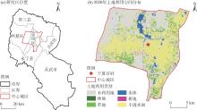
图1
研究区概况"
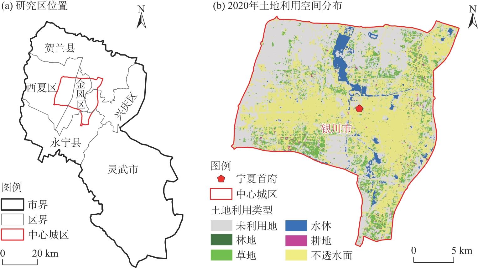
表1
阻力因子赋值及权重"
| 阻力因子 | 分级指标 | 阻力值 | 权重 |
|---|---|---|---|
| 土地利用 | 林地 | 10 | 0.2264 |
| 草地 | 20 | ||
| 水体 | 30 | ||
| 耕地 | 70 | ||
| 未利用地 | 100 | ||
| 建设用地 | 150 | ||
| NDVI | [-0.260, -0.038) | 150 | 0.2854 |
| [-0.038, 0.112) | 110 | ||
| [0.112, 0.197) | 90 | ||
| [0.197, 0.289) | 60 | ||
| [0.289, 0.401) | 30 | ||
| [0.401, 0.609] | 10 | ||
| MSPA景观 | 核心区 | 10 | 0.1264 |
| 桥接区 | 20 | ||
| 环岛 | 30 | ||
| 支线 | 40 | ||
| 孤岛 | 50 | ||
| 边缘区 | 70 | ||
| 孔隙 | 90 | ||
| 背景 | 100 | ||
| 与道路的距离/m | [0, 100) | 200 | 0.0874 |
| [100, 200) | 140 | ||
| [200, 300) | 90 | ||
| [300, 400) | 50 | ||
| [400, 500) | 20 | ||
| ≥500 | 10 | ||
| 距居民点距离/m | ≥2000 | 10 | 0.120 |
| [1500, 2000) | 20 | ||
| [1000, 1500) | 40 | ||
| [500, 1000) | 70 | ||
| <500 | 110 | ||
| 与水体的距离/m | [0, 100) | 10 | 0.1544 |
| [100, 200) | 20 | ||
| [200, 300) | 40 | ||
| [300, 400) | 70 | ||
| [400, 500) | 110 | ||
| ≥500 | 160 |
图2
技术路线"
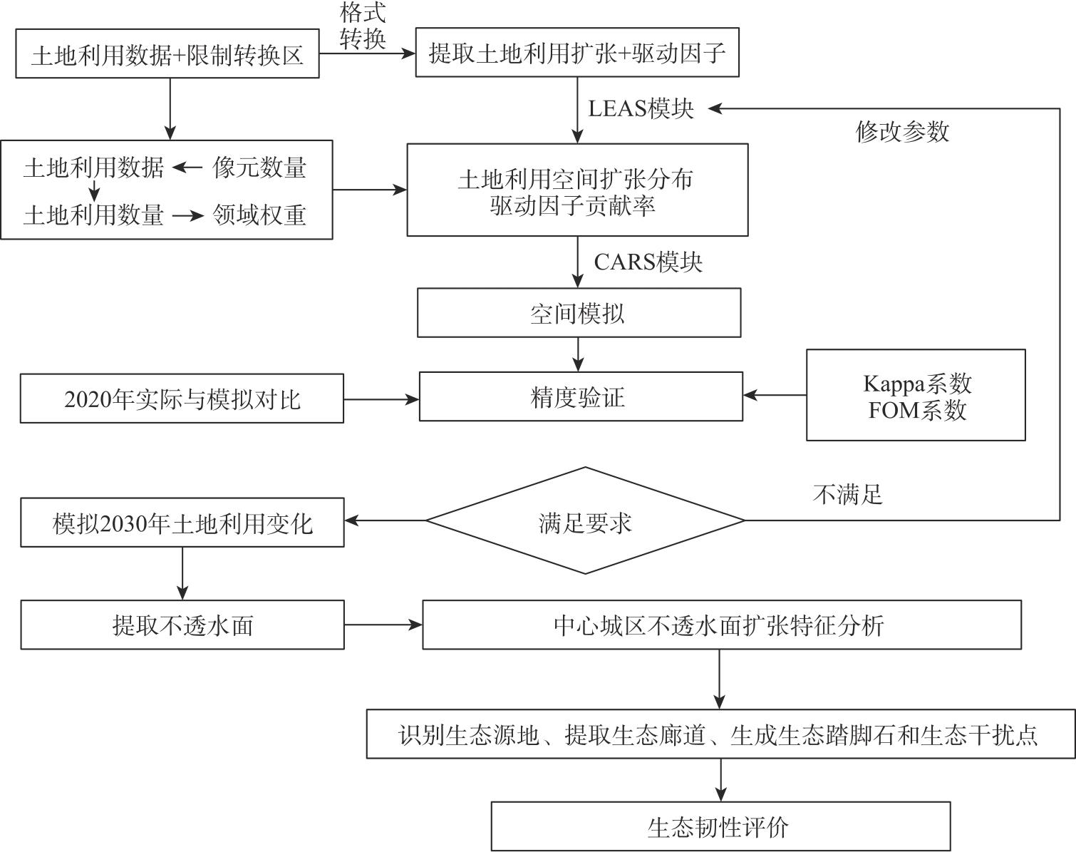
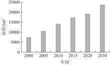
图3
2000—2030年银川市中心城区不透水面面积变化"
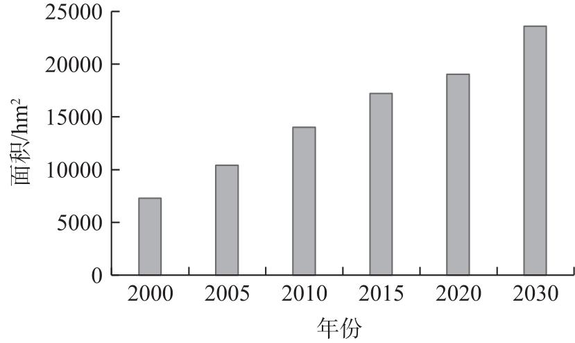
图4
2000—2030年银川市中心城区不透水面扩张变化"
图5
2000—2030年银川市中心城区不透水面标准差椭圆及重心变化"
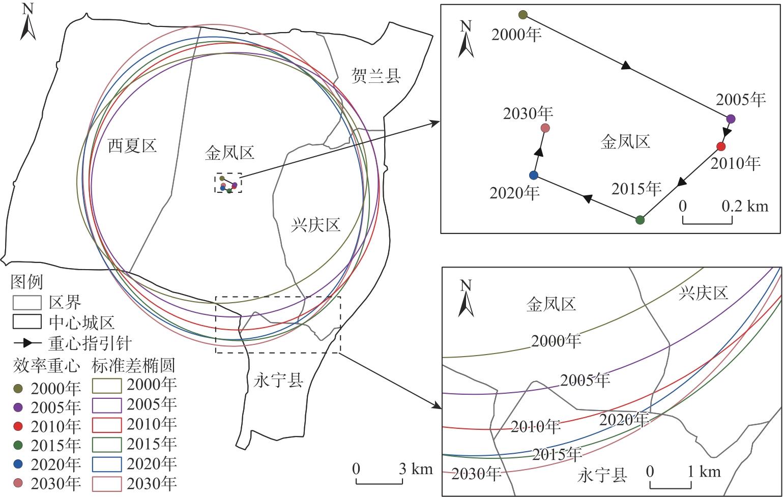
表2
2000—2030年银川市中心城区标准差椭圆参数变化统计"
| 参数 | 2000—2005年 | 2005—2010年 | 2010—2015年 | 2015—2020年 | 2020—2030年 |
|---|---|---|---|---|---|
| 椭圆长轴增减/km | 0.48 | 0.67 | 0.63 | 0.09 | 0.58 |
| 椭圆短轴增减/km | -0.12 | 0.18 | -0.56 | 0.04 | 0.04 |
| 直线距离/m | 940.57 | 125.19 | 446.14 | 911.66 | 200.21 |
| 重心迁移方向 | 东南方向 | 西南方向 | 西南方向 | 西北方向 | 东北方向 |
图6
2000—2030年银川市中心城区MSPA格局变化 注:MSPA为形态学空间格局分析。"
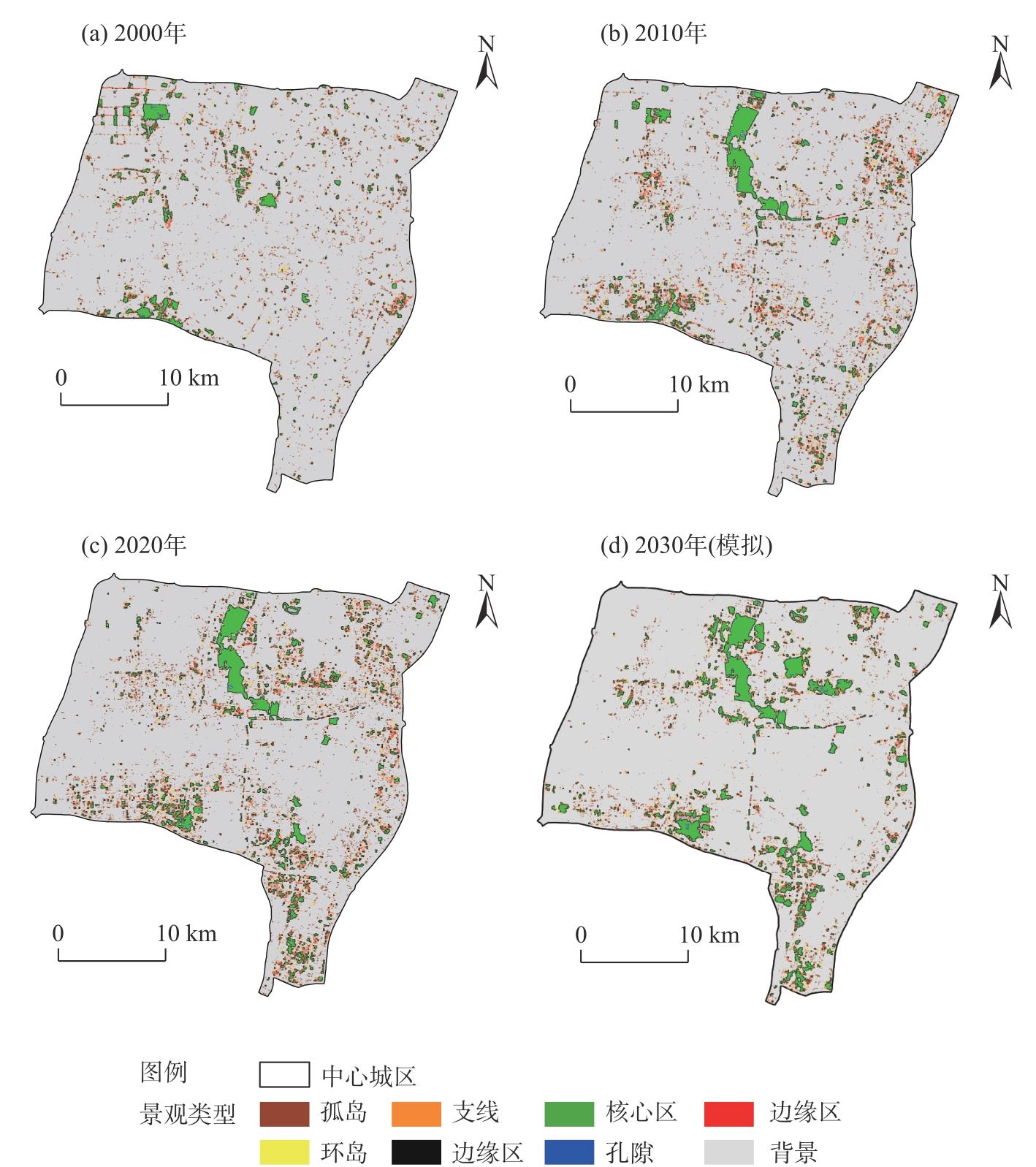
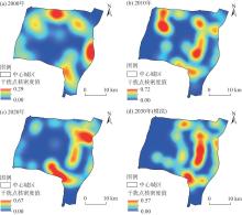
图7
2000—2030年银川市中心城区生态干扰点核密度变化"
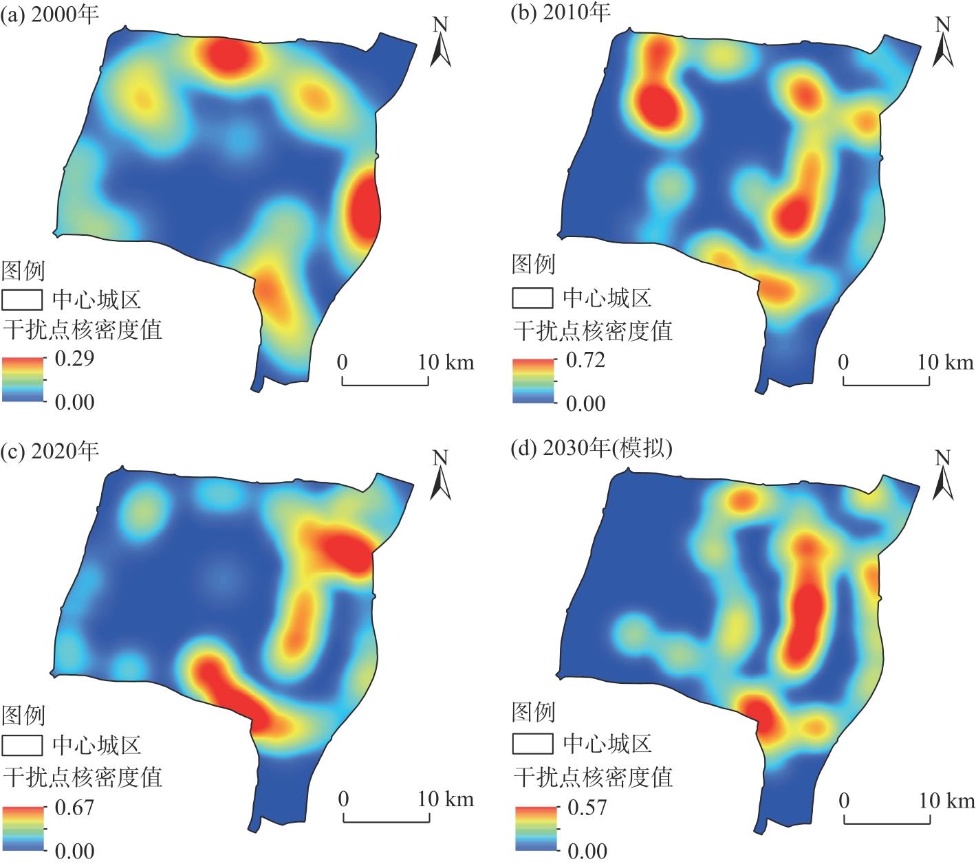
图8
2000—2030年银川市中心城区生态廊道及生态节点空间分布"
表3
优化前后的生态网络连接度指标比较"
| 指标 | 2000年 | 2010年 | 2020年 | 2030年 |
|---|---|---|---|---|
| α指数 | 0.14 | 0.16 | 0.23 | 0.55 |
| β指数 | 1.21 | 1.26 | 1.38 | 1.89 |
| γ指数 | 0.44 | 0.45 | 0.50 | 0.71 |
表4
生态网络多样性及传播性"
| 指标 | 2000年 | 2010年 | 2020年 | 2030年 |
|---|---|---|---|---|
| 网络传播性 | 0.32 | 0.37 | 0.40 | 0.41 |
| 网络多样性 | 1.25 | 1.52 | 1.54 | 1.58 |
| [1] | Hu H, Yan K G, Shi Y, et al. Decrypting resilience: The spatiotemporal evolution and driving factors of ecological resilience in the Yangtze River Delta urban agglomeration[J]. Environmental Impact Assessment Review, 2024, 106: 107540, doi: 10.1016/j.eiar.2024.107540. |
| [2] |
Bascompte J. Structure and dynamics of ecological networks[J]. Science, 2010, 329(5993): 765-766.
doi: 10.1126/science.1194255 pmid: 20705836 |
| [3] | 杨亮洁, 张玲玲, 张芳宁, 等. 生态安全格局视角下黄土高原生态网络韧性研究[J]. 生态学报, 2024, 44(22): 10471-10485. |
| [Yang Liangjie, Zhang Lingling, Zhang Fangning, et al. A study on the resilience of ecological networks in the Loess Plateau from the perspective of ecological security patterns[J]. Acta Ecologica Sinica, 2024, 44(22): 10471-10485. ] | |
| [4] | Liu Y Y, Ma C H, Yang Z H, et al. Ecological security of desert-oasis areas in the Yellow River Basin, China[J]. Land, 2023, 12(11): 2080, doi: 10.3390/land12112080. |
| [5] | 李红波, 黄悦, 高艳丽. 武汉城市圈生态网络时空演变及管控分析[J]. 生态学报, 2021, 41(22): 9008-9019. |
| [Li Hongbo, Huang Yue, Gao Yanli. Analysis on the spatial-temporal evolution and regulation of the ecological network in Wuhan metropolitan area[J]. Acta Ecologica Sinica, 2021, 41(22): 9008-9019. ] | |
| [6] | Zhu L Y, Song R X, Sun S, et al. Land use/land cover change and its impact on ecosystem carbon storage in coastal areas of China from 1980 to 2050[J]. Ecological lndicators, 2022, 142: 109178, doi: 10.1016/j.ecolind.2022.109178. |
| [7] | 金一诺, 黄银洲, 尤凤, 等. 基于Markov-PLUS模型的石羊河流域土地利用及生态系统服务价值模拟[J]. 干旱区资源与环境, 2024, 38(5): 130-139. |
| [Jin Yinuo, Huang Yinzhou, You Feng, et al. Simulation of land use and ecosystem service value in Shiyang River Basin based on Markov-PLUS model[J]. Journal of Arid land Resources and Environment, 2024, 38(5): 130-139. ] | |
| [8] |
Saadani S, Laajaj R, Maanan M, et al. Simulating spatial-temporal urban growth of a Moroccan metropolitan using CA-Markov model[J]. Spatial Information Research, 2020, 28: 609-621.
doi: 10.1007/s41324-020-00322-0 |
| [9] | Liang X, Liu X P, Li X, et al. Delineating multi-scenario urban growth boundaries with a CA-based FLUS model and morphological method[J]. Landscape and Urban Planning, 2018, 177: 47-63. |
| [10] | Liang X, Guan Q F, Clarke K C, et al. Understanding the drivers of sustainable land expansion using a patch-generating land use simulation (PLUS) model: A case study in Wuhan, China[J]. Computers, Environment and Urban Systems, 2021, 85: 101569, doi:10.1016/j.compenvurbsys.2020.101569. |
| [11] | 智菲, 周振宏, 赵铭, 等. 基于PLUS和InVEST模型的合肥市生态系统碳储量时空演变特征[J]. 水土保持学报, 2024, 38(2): 205-215. |
| [Zhi Fei, Zhou Zhenhong, Zhao Ming, et al. Temporal and spatial evolution characteristics of carbon storage in Hefei ecosystem based on PLUS and InVEST models[J]. Journal of Soil and Water Conservation, 2024, 38(2): 205-215. ] | |
| [12] |
徐海斌, 肖长江, 刘雅雯, 等. 基于PLUS模型的徐州市土地利用布局弹性空间模拟[J]. 资源科学, 2024, 46(1): 175-186.
doi: 10.18402/resci.2024.01.13 |
|
[Xu Haibin, Xiao Changjiang, Liu Yawen, et al. Simulation of flexible space of land use layout in Xuzhou City based on the PLUS model[J]. Resources Science, 2024, 46(1): 175-186. ]
doi: 10.18402/resci.2024.01.13 |
|
| [13] | 吴榛, 张凯云, 王浩. 城市扩张情景模拟下绿地生态网络构建与优化研究——以南京市部分区域为例[J]. 中国园林, 2022, 38(4): 56-61. |
| [Wu Zhen, Zhang Kaiyun, Wang Hao. Construction and optimization of green space ecological network under urban expansion scenario simulation: A case study in some areas of Nanjing[J]. Chinese Landscape Architecture, 2022, 38(4): 56-61. ] | |
| [14] | 李田田. 黄河流域城市韧性时空演变及影响因素研究[D]. 兰州: 兰州大学, 2023. |
| [Li Tiantian. Spatio-temporal evolution of urban resilience and its influencing factors in the Yellow River Basin[D]. Lanzhou: Lanzhou University, 2023. ] | |
| [15] |
王想, 王春雨, 吕飞南, 等. 基于PLUS-InVEST模型的区县碳储量时空格局变化与碳汇提升策略——以延庆区为例[J]. 应用生态学报, 2023, 34(12): 3373-3384.
doi: 10.13287/j.1001-9332.202312.019 |
|
[Wang Xiang, Wang Chunyu, Lü Feinan, et al. Temporal and spatial variations of carbon storage and carbon sink improvement strategy at the district and county level based on PLUS-InVEST model: Taking Yanqing District as an example[J]. Chinese Journal of Applied Ecology, 2023, 34(12): 3373-3384. ]
doi: 10.13287/j.1001-9332.202312.019 |
|
| [16] | 田一豆, 赵先超. 基于Markov-PLUS模型的长株潭城市群建设用地扩张模拟及碳排放响应分析[J]. 生态学报, 2024, 44(1): 129-142. |
| [Tian Yidou, Zhao Xianchao. Simulation of construction land expansion and carbon emission response analysis of Changsha-Zhuzhou-Xiangtan urban agglomeration based on Markov-PLUS model[J]. Acta Ecologica Sinica, 2024, 44(1): 129-142. ] | |
| [17] |
张艳, 李骏南, 潘博华. 基于PLUS模型的黄河流域生态系统服务评价及多情景预测——以陕西段为例[J]. 干旱区地理, 2024, 47(11): 1935-1946.
doi: 10.12118/j.issn.1000-6060.2023.651 |
| [Zhang Yan, Li Junnan, Pan Bohua. Evaluation and multi-scenario prediction of ecosystem services in the Yellow River Basin based on PLUS model: A case study of Shaanxi section[J]. Arid Land Geography, 2024, 47(11): 1935-1946. ] | |
| [18] | 张廷, 胡玉柱, 胡海辉, 等. 基于PLUS-InVEST模型的哈尔滨市土地利用及生境质量预测[J]. 环境科学, 2024, 45(8): 4709-4721. |
| [Zhang Ting, Hu Yuzhu, Hu Haihui, et al. Prediction of land use and habitat quality in Harbin City based on PLUS-InVEST model[J]. Environmental Science, 2024, 45(8): 4709-4721. ] | |
| [19] | 李琛, 高彬嫔, 吴映梅, 等. 基于PLUS模型的山区城镇景观生态风险动态模拟[J]. 浙江农林大学学报, 2022, 39(1): 84-94. |
| [Li Chen, Gao Binpin, Wu Yingmei, et al. Dynamic simulation of landscape ecological risk in mountainous based on PLUS model[J]. Journal of Zhejiang A & F University, 2022, 39(1): 84-94. ] | |
| [20] | 王兴丹, 刘普幸, 耿梦蝶, 等. 土地利用时空变化的关键驱动因子及其影响趋势——以武威市为例[J]. 中国环境科学, 2023, 43(12): 6583-6591. |
| [Wang Xingdan, Liu Puxing, Geng Mengdie, et al. The key driving factors of land use patio-temporal change and its influence trend: A case study of Wuwei[J]. Chinese Journal of Environmental Sciences, 2023, 43(12): 6583-6591. ] | |
| [21] | Vogt P, Riitters K H, Iwanowski M, et al. Mapping landscape corridors[J]. Ecological Indicators, 2007, 7(2): 481-488. |
| [22] |
马彩虹, 刘园园, 杨航, 等. 宁夏灵武市“生态-经济”双网格局演变及互作关系[J]. 应用生态学报, 2023, 34(11): 3095-3104.
doi: 10.13287/j.1001-9332.202311.020 |
|
[Ma Caihong, Liu Yuanyuan, Yang Hang, et al. Evolution and interaction relationship of “eco-economy” dual grid pattern in Lingwu City, Ningxia, China[J]. Chinese Journal of Applied Ecology, 2023, 34(11): 3095-3104. ]
doi: 10.13287/j.1001-9332.202311.020 |
|
| [23] |
和娟, 师学义, 付扬军. 基于生态系统服务的汾河源头区域生态安全格局优化[J]. 自然资源学报, 2020, 35(4): 814-825.
doi: 10.31497/zrzyxb.20200406 |
|
[He Juan, Shi Xueyi, Fu Yangjun. Optimization of ecological security pattern in the source area of Fenhe River Basin based on ecosystem services[J]. Journal of Natural Resources, 2020, 35(4): 814-825. ]
doi: 10.31497/zrzyxb.20200406 |
|
| [24] |
黄木易, 岳文泽, 冯少茹, 等. 基于MCR模型的大别山核心区生态安全格局异质性及优化[J]. 自然资源学报, 2019, 34(4): 771-784.
doi: 10.31497/zrzyxb.20190408 |
|
[Huang Muyi, Yue Wenze, Feng Shaoru, et al. Analysis of spatial heterogeneity of ecological security based on MCR model and ecological pattern optimization in the Yuexi County of the Dabie Mountain area[J]. Journal of Natural Resources, 2019, 34(4): 771-784. ]
doi: 10.31497/zrzyxb.20190408 |
|
| [25] | 周英, 施成超, 刘滢, 等. 基于MSPA-MCR模型的云南德昂族乡景观生态安全格局构建[J]. 西南林业大学学报(社会科学), 2022, 6(1): 54-62. |
| [Zhou Ying, Shi Chengchao, Liu Ying, et al. Construction of landscape ecological security pattern of Deang ethnic township in Yunnan based on MSPA-MCR model[J]. Journal of Southwest Forestry University (Social Sciences Edition), 2022, 6(1): 54-62. ] | |
| [26] | 孔阳, 王思元. 基于MSPA模型的北京市延庆区城乡生态网络构建[J]. 北京林业大学学报, 2020, 42(7): 113-121. |
| [Kong Yang, Wang Siyuan. Construction of urban and rural ecological network in Yanqing District of Beijing based on MSPA model[J]. Journal of Beijing Forestry University, 2020, 42(7): 113-121. ] | |
| [27] | Hong W Y, Guo R Z, Li X M, et al. Measuring urban ecological network resilience: A disturbance scenario simulation method[J]. Cities, 2022, 131, 104057, doi: 10.1016/j.cities.2022.104057. |
| [28] | Yang J, Huang X. The 30 m annual land cover datasets and its dynamics in China from 1985 to 2022[J]. Earth System Science Data, 2023, 13(1): 3907-3925. |
| [29] |
黄梅, 刘晨曦, 俞晓莹, 等. 城市水生态网络韧性评价与优化策略——以长沙市为例[J]. 经济地理, 2022, 42(10): 52-60.
doi: 10.15957/j.cnki.jjdl.2022.10.007 |
| [Huang Mei, Liu Chenxi, Yu Xiaoying, et al. Resilience evaluation and optimization of urban water ecological network: Take Changsha as an example[J]. Economic Geography, 2022, 42(10): 52-60. ] | |
| [30] | 吴一洲, 姚申益, 吴思琴, 等. 海岛城市生态安全格局构建与优化策略研究——以舟山本岛为例[J]. 长江流域资源与环境, 2022, 31(12): 2693-2705. |
| [Wu Yizhou, Yao Shenyi, Wu Siqin, et al. Construction and optimization strategy of ecological security pattern in the island city: A case study of Zhoushan Island[J]. Resources and Environment in the Yangtze Basin, 2022, 31(12): 2693-2705. ] | |
| [31] | 王正伟, 王宏卫, 杨胜天, 等. 基于生态系统服务功能的新疆绿洲生态安全格局识别及优化策略——以拜城县为例[J]. 生态学报, 2022, 42(1): 91-104. |
| [Wang Zhengwei, Wang Hongwei, Yang Shengtian, et al. Identification and optimization strategy of ecological security pattern of oasis in Xinjiang based on ecosystem service function: Taking Baicheng County as an example[J]. Acta Ecologica Sinica, 2022, 42(1): 91-104. ] | |
| [32] | Huang X X, Wang H J, Shan L Y, et al. Constructing and optimizing urban ecological network in the context of rapid urbanization for improving landscape connectivity[J]. Ecological Indicators, 2021, 132: 108319, doi: 10.1016/j.ecolind.2021.108319. |
| [1] | 郭佳丽, 杜宏茹. 多元流视角下新疆绿洲城市网络格局研究[J]. 干旱区地理, 2025, 48(2): 323-332. |
| [2] | 张傲翔, 苗成林, 陈峥妍. 黄河流域城市生态韧性、社会网络及其影响因素分析[J]. 干旱区地理, 2025, 48(1): 130-142. |
| [3] | 杨燕燕, 王永瑜, 徐绮阳. 黄河流域水资源利用驱动因素及脱钩效应研究[J]. 干旱区地理, 2025, 48(1): 20-30. |
| [4] | 陈聪, 唐英, 史承勇, 杜怡帆, 赵丽娜, 姜旭妍. 黄河流域遗产资源空间分布与区域协同保护[J]. 干旱区地理, 2024, 47(7): 1220-1232. |
| [5] | 侯晋星, 潘换换, 杜自强, 武志涛, 张红. 山西黄河流域水生态系统服务时空分析[J]. 干旱区地理, 2024, 47(6): 1047-1060. |
| [6] | 许忠洋, 王琤, 顾彤, 王诗雨, 裴晨阳, 张青峰. 基于生态网络的生态修复关键区识别——以延安市为例[J]. 干旱区地理, 2024, 47(6): 1073-1083. |
| [7] | 董晓媛, 胥德泽, 施小斌, 杜森. 黄河流域甘肃段生态敏感性评价研究——以广河县为例[J]. 干旱区地理, 2024, 47(4): 599-611. |
| [8] | 付玮, 夏文浩, 樊童生, 邹贞, 霍瑜. 塔里木河流域生态系统碳储量的情景预测分析[J]. 干旱区地理, 2024, 47(4): 634-647. |
| [9] | 王嘉嘉, 张轲. 生态保护视角下的黄河流域高质量发展非均衡性及演进趋势分析[J]. 干旱区地理, 2024, 47(4): 695-706. |
| [10] | 慕石雷, 杨玉欢, 乌日陶克套胡. 黄河流域五大城市群PM2.5时空演变与影响因素探讨[J]. 干旱区地理, 2024, 47(4): 707-719. |
| [11] | 吴尚, 翟彬, 程利莎. 黄河流域城市创新能力测度及空间分异研究[J]. 干旱区地理, 2024, 47(4): 720-732. |
| [12] | 张明斗, 任衍婷, 周亮. 黄河流域城市生态韧性时空演变特征及影响因素分析[J]. 干旱区地理, 2024, 47(3): 445-454. |
| [13] | 周成, 赵亚玲, 任敏敏, 靳轶婷, 吕丝丝. 黄河流域国家湿地公园时空分异、重心演化与驱动因素分析[J]. 干旱区地理, 2024, 47(3): 506-514. |
| [14] | 王慧娴, 杨蓓, 杨宁君, 李璐瑶. 黄河流域旅游经济差异及关键驱动因素研究[J]. 干旱区地理, 2024, 47(3): 515-527. |
| [15] | 石彩霞, 贺小荣. “双碳”目标下黄河流域城市绿色发展效率测度及提升路径[J]. 干旱区地理, 2024, 47(3): 528-538. |
| Viewed | ||||||||||||||||||||||||||||||||||||||||||||||||||
|
Full text 32
|
|
|||||||||||||||||||||||||||||||||||||||||||||||||
|
Abstract 51
|
|
|||||||||||||||||||||||||||||||||||||||||||||||||
Cited |
|
|||||||||||||||||||||||||||||||||||||||||||||||||
| Shared | ||||||||||||||||||||||||||||||||||||||||||||||||||
|
||