Arid Land Geography ›› 2021, Vol. 44 ›› Issue (1): 158-167.doi: 10.12118/j.issn.1000–6060.2021.01.17
• Earth Surface Process • Previous Articles Next Articles
GU Jiahe1,2( ),XUE Huazhu1,DONG Guotao2,3(),ZHOU Lijuan1,LI Jingru1,DANG Suzhen2,LI Shangzhi1
Received:2020-05-08
Revised:2020-08-24
Online:2021-01-25
Published:2021-03-09
Contact:
Guotao DONG
E-mail:m15227158030@163.com;dongguotao@hky.yrcc.gov.cn
GU Jiahe,XUE Huazhu,DONG Guotao,ZHOU Lijuan,LI Jingru,DANG Suzhen,LI Shangzhi. Effects of NDVI/land-use on spatiotemporal changes of evapotranspiration in the Yellow River Basin[J].Arid Land Geography, 2021, 44(1): 158-167.

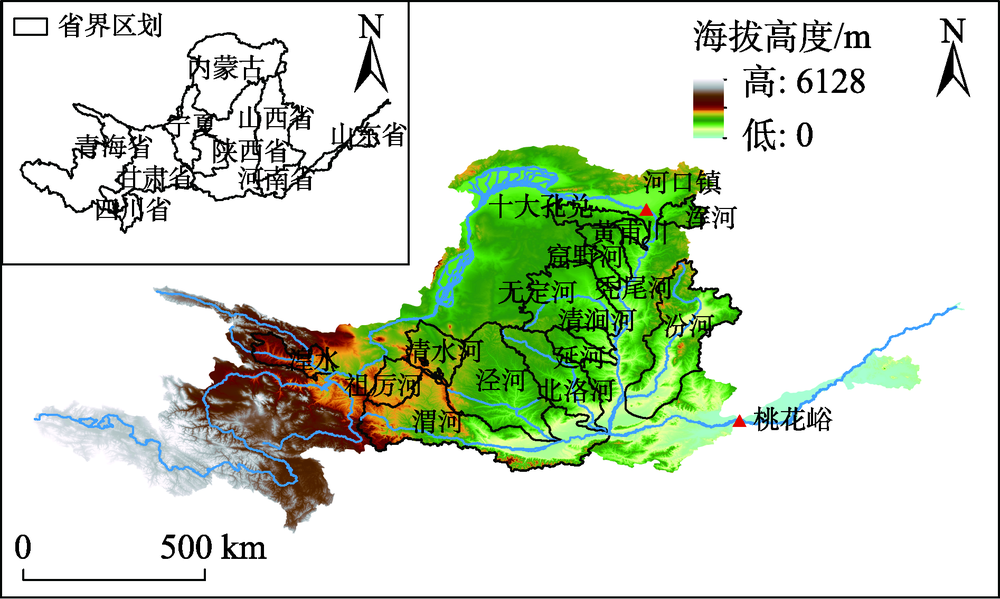
Fig. 1
Location diagram of the Yellow River Basin"
Tab. 1
Land-use reclassification"
| 重分类 | IPGP全球植被分类 |
|---|---|
| 1林地 | 1常绿针叶林 |
| 2常绿阔叶林 | |
| 3落叶针叶林 | |
| 4落叶阔叶林 | |
| 5混交林 | |
| 6稠密灌丛 | |
| 7稀疏灌丛 | |
| 2草地 | 8木本热带稀树草原 |
| 9热带稀树草原 | |
| 10草地 | |
| 16稀疏植被 | |
| 3湿地 | 11永久湿地 |
| 4农用地 | 12农用地 |
| 14农用地/自然植被拼接 | |
| 5建筑用地 | 13城市和建筑区 |
| 6水体 | 15雪和冰 |
| 17水 |
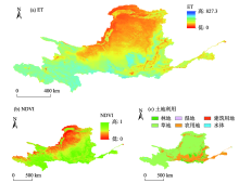
Fig. 2
Spatial distributions of ET, NDVI and land-use in the Yellow River Basin"

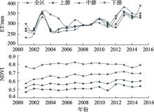
Fig. 3
Changes of ET and NDVI time series in the Yellow River Basin"


Fig. 4
Area changes of land-use types in the Yellow River Basin"
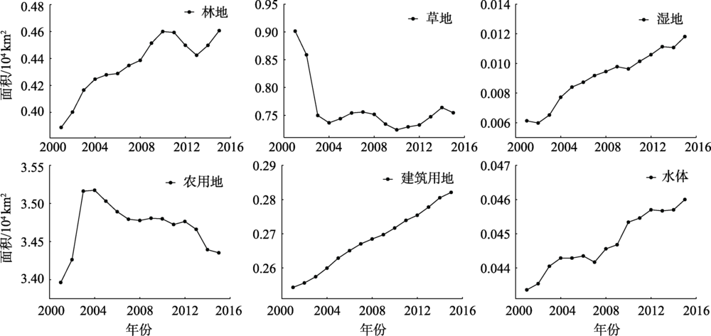

Fig. 5
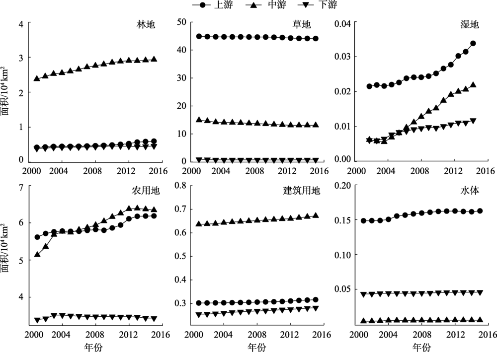
Area changes of land-use types in upper, middle and lower reaches of the Yellow River Basin"
Tab. 2
Average NDVI and NDVI grade ratio of each river section and the whole area in the study area"
| 河段 | 平均NDVI | NDVI等级/% | ||||
|---|---|---|---|---|---|---|
| <0.2 | 0.2~0.4 | 0.4~0.6 | 0.6~0.8 | >0.8 | ||
| 上游 | 0.53 | 7.04 | 25.57 | 25.54 | 30.61 | 11.16 |
| 中游 | 0.69 | 0.13 | 4.71 | 21.59 | 47.47 | 26.10 |
| 下游 | 0.76 | 0.11 | 1.07 | 7.96 | 48.47 | 42.33 |
| 全区 | 0.59 | 4.62 | 18.02 | 23.31 | 36.57 | 17.14 |
Tab. 3
Average ET and ET grade ratio of each river section and the whole area in the study area"
| 河段 | 平均ET/mm | ET等级/% | ||||
|---|---|---|---|---|---|---|
| <200 mm | 200~400 mm | 400~600 mm | 600~800 mm | >800 mm | ||
| 上游 | 318.70 | 30.41 | 32.99 | 36.51 | 0.09 | 0 |
| 中游 | 316.69 | 13.69 | 63.19 | 22.45 | 0.71 | 0 |
| 下游 | 337.70 | 4.60 | 74.70 | 20.14 | 0.56 | 0 |
| 全区 | 319.24 | 23.99 | 44.30 | 31.42 | 0.30 | 0 |
Tab. 4
Variation trends of NDVI and ET in the whole study area and different river sections"
| 河段 | NDVI | ET | |||||
|---|---|---|---|---|---|---|---|
| Zc | β | 趋势 | Zc | β | 趋势 | ||
| 上游 | 1.59* | 0.004 | 显著增加 | 0.88 | 4.02 | 不显著增加 | |
| 中游 | 2.10* | 0.007 | 显著增加 | 1.65* | 8.26 | 显著增加 | |
| 下游 | 0.06 | -0.001 | 不显著减少 | 0.68 | 3.55 | 不显著增加 | |
| 全区 | 0.58 | 0.005 | 不显著增加 | 1.09 | 1.87 | 不显著增加 | |
Tab. 5
Proportions of NDVI with different rate of change in the whole area and river sections of the study area"
| 河段 | NDVI变化速率等级/% | ||||
|---|---|---|---|---|---|
| <-0.005 | -0.005~0 | 0~0.005 | 0.005~0.01 | >0.01 | |
| 上游 | 0.81 | 13.27 | 51.55 | 24.48 | 9.89 |
| 中游 | 2.98 | 6.84 | 27.15 | 32.61 | 30.41 |
| 下游 | 14.77 | 33.19 | 36.78 | 11.96 | 0.3 |
| 全区 | 2.3 | 13.02 | 43.62 | 25.92 | 15.14 |
Tab. 6
Proportions of ET with different rate of change in the whole area and river sections of the study area"
| 河段 | ET变化速率等级/mm·a-1 | |||||
|---|---|---|---|---|---|---|
| -4 | -4~0 | 0~4 | 4~8 | 8~12 | >12 | |
| 上游 | 1.79 | 16.44 | 39.05 | 23.82 | 11.90 | 7.00 |
| 中游 | 2.53 | 3.02 | 16.05 | 26.83 | 25.50 | 26.07 |
| 下游 | 9.27 | 15.50 | 24.01 | 28.27 | 16.41 | 6.53 |
| 全区 | 2.46 | 12.47 | 31.51 | 24.97 | 16.09 | 12.49 |
Fig. 6
Spatial distribution of correlation coefficients between ET and NDVI"

Fig. 7
Land-use types and evapotranspiration changes in the Yellow River Basin"

| [1] |
叶红, 张廷斌, 易桂花, 等. 2000—2014年黄河源区ET时空特征及其与气候因子关系[J]. 地理学报, 2018,73(11):2117-2134.
doi: 10.11821/dlxb201811006 |
|
[ Ye Hong, Zhang Tingbin, Yi Guihua, et al. Spatio-temporal characteristics of evapotranspiration and its relationship with climate factors in the source region of the Yellow River from 2000 to 2014[J]. Acta Geographica Sinica, 2018,73(11):2117-2134. ]
doi: 10.11821/dlxb201811006 |
|
| [2] | 姜艳阳, 王文, 周正昊. MODIS MOD16蒸散发产品在中国流域的质量评估[J]. 自然资源学报, 2017,32(3):517-528. |
| [ Jiang Yanyang. Wang Wen, Zhou Zhenghao. Evaluation of MODIS MOD16 evaportranspiration product in Chinese river basins[J]. Journal of Natural Resources, 2017,32(3):517-528. ] | |
| [3] |
曹文旭, 张志强, 查同刚, 等. 基于Budyko假设的潮河流域气候和植被变化对实际蒸散发的影响研究[J]. 生态学报, 2018,38(16):5750-5758.
doi: 10.5846/stxb201708031390 |
|
[ Cao Wenxu, Zhang Zhiqiang, Zha Tonggang, et al. Exploring the effects of vegetation dynamics and climate changes on the Chaohe watershed actual evapotranspiration: Budyko Hypojournal approach[J]. Acta Ecologica Sinica, 2018,38(16):5750-5758. ]
doi: 10.5846/stxb201708031390 |
|
| [4] |
邓兴耀, 刘洋, 刘志辉, 等. 中国西北干旱区蒸散发时空动态特征[J]. 生态学报, 2017,37(9):2994-3008.
doi: 10.5846/stxb201601270190 |
|
[ Deng Xingyao, Liu Yang, Liu Zhihui, et al. Temporal-spatial dynamic change characteristics of evapotranspiration in arid region of northwest China[J]. Acta Ecologica Sinica, 2017,37(9):2994-3008. ]
doi: 10.5846/stxb201601270190 |
|
| [5] | 杨秀芹, 王国杰, 潘欣 等. 基于GLEAM遥感模型的中国1980—2011年地表蒸散发时空变化[J]. 农业工程学报, 2015,31(21):132-141. |
| [ Yang Xiuqin, Wang Guojie, Pan Xin, et al. Spatio-temporal variability of terrestrial evapotranspiration in China from 1980 to 2011 based on GLEAM data[J]. Journal of Agricultural Engineering, 2015,31(21):132-141. ] | |
| [6] | 董晴晴, 占车生, 王会肖, 等. 2000年以来的渭河流域实际蒸散发时空格局分析[J]. 干旱区地理, 2016,166(2):97-105. |
| [ Dong Qingqing, Zhan Chesheng, Wang Huixiao, et al. Spatio-temporal patterns of actual evapotranspiration in the Weihe River Basin since 2000[J]. Arid Land Geography, 2016,166(2):97-105. ] | |
| [7] | 孙永军, 周强, 杨日红. 黄河流域土地荒漠化动态变化遥感研究[J]. 国土资源遥感, 2009,20(2):74-78. |
| [ Sun Yongjun, Zhou Qiang, Yang Rihong. A study of land desertification dynamic change in Yellow River Basin[J]. Remote Sensing of Land and Resources, 2009,20(2):74-78. ] | |
| [8] | 王思远, 王光谦, 陈志祥. 黄河流域生态环境综合评价及其演变[J]. 山地学报, 2004,22(2):133-139. |
| [ Wang Siyuan, Wang Guangqian, Chen Zhixiang. Eco-environmental evaluation and changes in Yellow River Basin[J]. Journal of Mountain Science, 2004,22(2):133-139. ] | |
| [9] | 金翠, 张柏, 宋开山, 等. 土地利用/覆被变化对区域蒸散发影响的遥感分析——以吉林省乾安县为例[J]. 干旱区研究, 2009,26(5):734-743. |
| [ Jin Cui, Zhang Bai, Song Kaishan, et al. RS-based analysis on the effects of land use/cover change on regional evapotranspiration: A case study Qian’ an County, Jilin Province[J]. Arid Zone Research, 2009,26(5):734-743. ] | |
| [10] | 王燕鑫, 李瑞平, 李夏子. 河套灌区不同土地类型生长季蒸散发量估算及其变化特征[J]. 干旱区研究, 2020,37(2):364-373. |
| [ Wang Yanxin, Li Ruiping, Li Xiazi. Estimation and variability of evapotranspiration for different land types during the growing season in the Hetao Irrigation District[J]. Arid Zone Research, 2020,37(2):364-373. ] | |
| [11] | 曾丽红, 宋开山, 张柏, 等. 基于SEBAL模型与MODIS产品的松嫩平原蒸散量研究[J]. 干旱区资源与环境, 2011,25(1):140-147. |
| [ Zeng Lihong, Song Kaishan, Zhang Bai, et al. Study on regional evapotranspiration over Songnen Plain based on SEBAL model and MODIS products[J]. Arid Land Resources and Environment, 2011,25(1):140-147. ] | |
| [12] | Ruhoff A L, Paz A R, Aragao L E O C, et al. Assessment of the MODIS global evapotranspiration algorithm using eddy covariance measurements and hydrological modelling in the Rio Grande Basin[J]. International Association of Scientific Hydrology Bulletin, 2013,58(8):1658-1676. |
| [13] | 钟巧, 焦黎, 李稚, 等. 博斯腾湖流域潜在蒸散发时空演变及归因分析[J]. 干旱区地理, 2019,42(1):103-112. |
| [ Zhong Qiao, Jiao Li, Li Zhi, et al. Spatial and temporal changes of potential evapotranspiration and its attribution in the Bosten Lake Basin[J]. Arid Land Geography, 2019,42(1):103-112. ] | |
| [14] | 张翔, 朱晓昱, 沈贝贝, 等. 呼伦贝尔植被蒸散发时空变化研究[J]. 中国农业资源与区划, 2020,41(4):308-316. |
| [ Zhang Xiang, Zhu Xiaoyu, Shen Beibei, et al. Analysis of temporal and spatial variation of vegetation evaportranspiration in Hulunbuir[J]. China’s Agricultural Resources and Regionalization, 2020,41(4):308-316. ] | |
| [15] |
尹云鹤, 吴绍洪, 赵东升, 等. 1981—2010年气候变化对青藏高原实际蒸散的影响[J]. 地理学报, 2012,67(11):1471-1481.
doi: 10.11821/xb201211004 |
|
[ Yin Yunhe, Wu Shaohong, Zhao Dongsheng, et al. Impact of climate change on actual evapotranspiration on the Tibetan Plateau during 1981—2010[J]. Acta Geographica Sinica, 2012,67(11):1471-1481. ]
doi: 10.11821/xb201211004 |
|
| [16] | 刘蓉, 文军, 王欣. 黄河源区蒸散发量时空变化趋势及突变分析[J]. 气候与环境研究, 2016,21(5):503-511. |
| [ Liu Rong, Wen Jun, Wang Xin. Spatial-temporal variation and abrupt analysis of evapotranspiration over the Yellow River source region[J]. Climatic and Environmental Research, 2016,21(5):503-511. ] | |
| [17] | 韩盟伟, 赵广举, 穆兴民, 等. 黄土高原1959—2015年潜在蒸发量的时空变化[J]. 干旱区地理, 2017,40(5):997-1004. |
| [ Han Mengwei, Zhao Guangju, Mu Xingmin, et al. Spatial and temporal variations of potential evapotranspiration on the Loess Plateau during 1959—2015[J]. Arid Land Geography, 2017,40(5):997-1004. ] | |
| [18] |
邓兴耀, 刘洋, 刘志辉, 等. 中国西北干旱区蒸散发时空动态特征[J]. 生态学报, 2017,37(9):2994-3008.
doi: 10.5846/stxb201601270190 |
|
[ Deng Xingyao, Liu Yang, Liu Zhihui, et al. Temporal-spatial dynamic change characteristics of evapotranspiration in arid region of northwest China[J]. Acta Ecologica Sinica, 2017,37(9):2994-3008. ]
doi: 10.5846/stxb201601270190 |
|
| [19] |
Wang Y, Liu Y B, Jin J X. Contrast effects of vegetation cover change on evapotranspiration during a revegetation period in the Poyang Lake Basin, China[J]. Forests, 2018,9(4):217-230.
doi: 10.3390/f9040217 |
| [20] |
Wu R J, Xing X R. Variation characteristics and influencing factors of actual evapotranspiration under various vegetation types: A case study in the Huaihe River Basin, China[J]. Journal of Applied Ecology, 2016,27(6):1727-1736.
doi: 10.13287/j.1001-9332.201606.040 pmid: 29737678 |
| [21] | Ma Z, Yan N, Wu B, et al. Variation in actual evapotranspiration following changes in climate and vegetation cover during an ecological restoration period (2000—2015) in the Loess Plateau, China[J]. Science of the Total Environment, 2019,689:564-545. |
| [22] |
阮宏威, 于静洁. 1992—2015年中亚五国土地覆盖与蒸散发变化[J]. 地理学报, 2019,74(7):1292-1304.
doi: 10.11821/dlxb201907002 |
|
[ Ruan Hongwei, Yu Jingjie. Changes in land cover and evapotranspiration in the five Central Asian countries from 1992 to 2015[J]. Acta Geographica Sinica, 2019,74(7):1292-1304. ]
doi: 10.11821/dlxb201907002 |
|
| [23] |
Yan N N, Tian F Y, Wu B F, et al. Spatiotemporal analysis of actual evapotranspiration and its causes in the Hai Basin[J]. Remote Sensing, 2018,10(2):332-348.
doi: 10.3390/rs10020332 |
| [24] |
Liu M Q, Hu D Y. Response of wetland evapotranspiration to land use/cover change and climate change in Liaohe River Delta, China[J]. Water, 2019,11(5):955-970.
doi: 10.3390/w11050955 |
| [25] | He Z, He J P. Spatio-temporal variation of vegetation cover based on SPOT-VGT in Yellow River Basin[J]. Ecology and Environmental Sciences, 2012,21(10):1655-1659. |
| [26] | Liu L L, Xiao F J. Spatial-temporal correlations of NDVI with precipitation and temperature in Yellow River Basin[J]. Chinese Journal of Ecology, 2006,25(5):477-481. |
| [27] | 田智慧, 张丹丹, 赫晓慧, 等. 2000—2015年黄河流域植被净初级生产力时空变化特征及其驱动因子[J]. 水土保持研究, 2019,26(2):259-266. |
| [ Tian Zhihui, Zhang Dandan, He Xiaohui, et al. Spatiotemporal variations in vegetation net primary productivity and their driving factors in Yellow River Basin from 2000 to 2015[J]. Research of Soil and Water Coservation, 2019,26(2):259-266. ] | |
| [28] | 秦年秀, 姜彤. 2003年重大自然灾害回顾[J]. 自然灾害学报, 2005,14(1):38-44. |
| [ Qin Nianxiu, Jiang Tong. A review on global natural disasters in 2003[J]. Journal of Natural Disasters, 2005,14(1):38-44. ] | |
| [29] | 陈晓菲, 任立良, 江善虎, 等. 赣江上游流域蒸散发量影响因素的遥感分析[J]. 水资源保护, 2014,30(2):33-37. |
| [ Chen Xiaofei, Ren Liliang, Jiang Shanhu, et al. RS-based analysis of factors influencing evapotranspiration in upstream region of Ganjiang Basin[J]. Water Resources Protection, 2014,30(2):33-37. ] | |
| [30] | 张殿君, 张学霞, 武鹏飞, 等. 黄土高原典型流域土地利用变化对蒸散发影响研究[J]. 干旱区地理, 2011,34(3):400-408. |
| [ Zhang Dianjun, Zhang Xuexia, Wu Pengfei, et al. Relationship between ET and LUCC in a typical watershed of Loess Plateau over the past 20 years[J]. Arid Land Geography, 2011,34(3):400-408. ] |
|
||