- May. 10, 2025
Arid Land Geography ›› 2024, Vol. 47 ›› Issue (1): 15-27.doi: 10.12118/j.issn.1000-6060.2023.353
• Climatology and Hydrology • Previous Articles Next Articles
WU Xiaodan1,2( ),LUO Min1,2(),MENG Fanhao1,2,SA Chula1,2,DONG Jinyi1,2,LIU Tie3
Received:2023-07-11
Revised:2023-09-12
Online:2024-01-25
Published:2024-01-26
WU Xiaodan, LUO Min, MENG Fanhao, SA Chula, DONG Jinyi, LIU Tie. Evolution law and causes of floods in the four sources streams of Tarim River[J].Arid Land Geography, 2024, 47(1): 15-27.
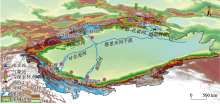
Fig. 1
Location diagram of Tarim River Basin"

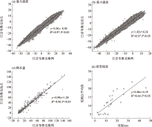
Fig. 2
Comparison diagram of site and grid data verification"

Tab. 1
Nine flood indicators used in the study"
| 洪水指标定义 | 简称 | 单位 |
|---|---|---|
| 年最大1 d流量 | AMF | m3 |
| 年最大1 d流量发生日期 | AMFD | d |
| 春季(3—5月)最大1 d流量 | AMFSp | m3 |
| 夏季(6—8月)最大1 d流量 | AMFSu | m3 |
| 秋季(9—11月)最大1 d流量 | AMFAu | m3 |
| 冬季(12月—次年2月)最大1 d流量 | AMFWi | m3 |
| POT超过阈值洪峰流量 | POT3M | m3 |
| 每年POT样本数量 | POT3F | 次 |
| 每年POT洪水发生平均日期 | MDF | d |
Tab. 2
Multi-year mean values of each flood indicator"
| 站点名称 | AMFSp /m3·s-1 | AMFSu /m3·s-1 | AMFAu /m3·s-1 | AMFWi /m3·s-1 | AMF /m3·s-1 | AMFD /d | POT3M /m3·s-1 | POT3F /次 | MDF /d |
|---|---|---|---|---|---|---|---|---|---|
| 沙里桂兰克 | 375.19 | 537.52 | 209.76 | 31.22 | 568.65 | 180.48 | 608.38 | 4.89 | 180.24 |
| 协和拉 | 240.17 | 1326.45 | 399.03 | 77.87 | 1326.45 | 214.00 | 1157.89 | 3.33 | 212.91 |
| 大山口 | 236.90 | 390.65 | 195.75 | 89.79 | 399.35 | 214.18 | 459.23 | 7.50 | 195.70 |
| 同古孜洛克 | 71.08 | 637.13 | 192.77 | 14.02 | 637.13 | 188.25 | 677.50 | 4.60 | 211.31 |
| 卡群 | 159.88 | 1423.10 | 580.18 | 70.46 | 1423.10 | 217.08 | 1505.56 | 5.72 | 215.20 |
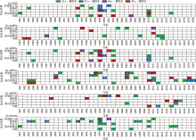
Fig. 3
Time distribution of flood index recurrence period at each hydrological station"

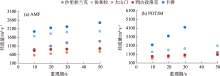
Fig. 4
Peak discharge in different return period"
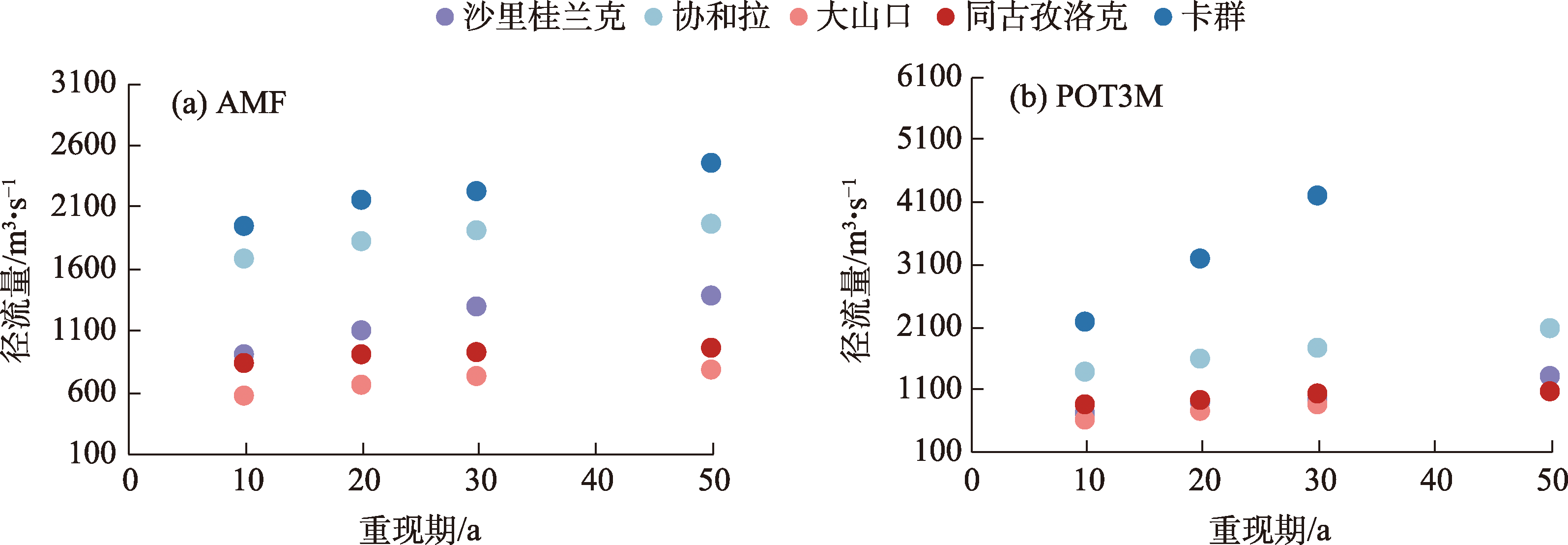
Fig. 5
Time variation trend of each flood index in the Tarim River Basin"

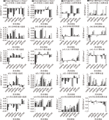
Fig. 6
Variation trends of maximum temperature, minimum temperature, snow depth, and precipitation at different times before the flood occurred"
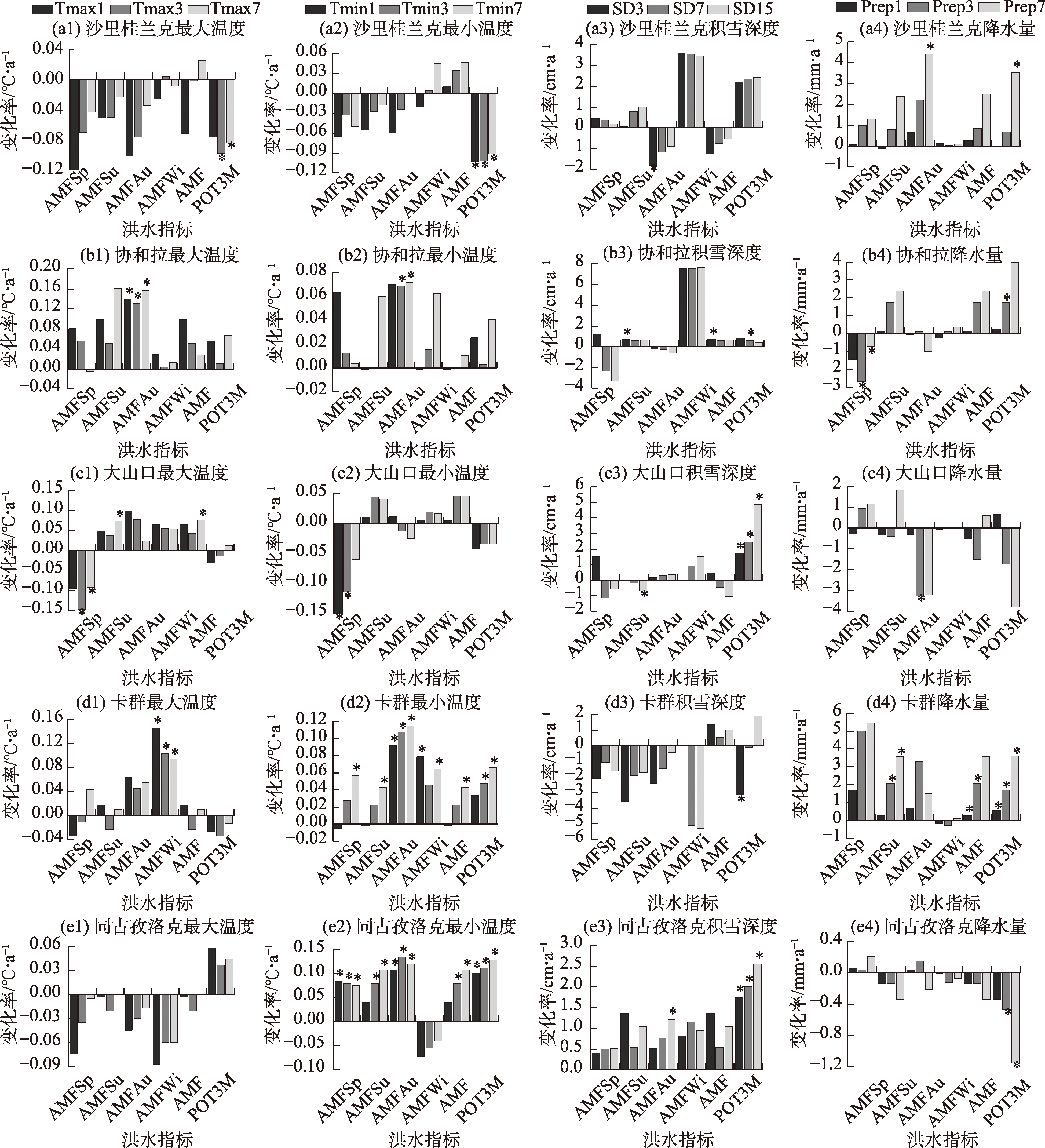
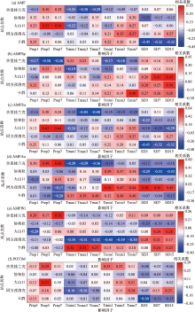
Fig. 7
Correlation between flood indicators and influencing factors at different hydrological stations in the Tarim River Basin"

| [1] | IPCC. Climate change 2022: Impacts, adaptation, and vulnerability[R]. Cambridge: Cambridge University Press, 2022. |
| [2] |
Hirabayashi Y, Mahendran R, Koirala S, et al. Global flood risk under climate change[J]. Nature Climate Change, 2013, 3(9): 816-821.
doi: 10.1038/nclimate1911 |
| [3] |
Devitt L, Neal J, Coxon G, et al. Flood hazard potential reveals global floodplain settlement patterns[J]. Nature Communications, 2023, 14(1): 2801, doi: 10.1038/s41467-023-38297-9.
pmid: 37193705 |
| [4] |
陈亚宁, 李稚, 方功焕, 等. 气候变化对中亚天山山区水资源影响研究[J]. 地理学报, 2017, 72(1): 18-26.
doi: 10.11821/dlxb201701002 |
|
[Chen Yaning, Li Zhi, Fang Gonghuan, et al. Impact of climate change on water resources in the Tianshan Mountains, Central Asia[J]. Acta Geographica Sinica, 2017, 72(1): 18-26.]
doi: 10.11821/dlxb201701002 |
|
| [5] |
Blöschl G, Hall J, Viglione A, et al. Changing climate both increases and decreases European river floods[J]. Nature, 2019, 573(7772): 108-111.
doi: 10.1038/s41586-019-1495-6 |
| [6] |
Fang G H, Yang J, Li Z, et al. Shifting in the global flood timing[J]. Scientific Reports, 2022, 12(1): 18853, doi: 10.1038/s41598-022-23748-y.
pmid: 36344741 |
| [7] | 杨涛, 陆桂华, 李会会, 等. 气候变化下水文极端事件变化预测研究进展[J]. 水科学进展, 2011, 22(2): 279-286. |
| [Yang Tao, Lu Guihua, Li Huihui, et al. Advances in the study of projection of climate change impacts on hydrological extremes[J]. Advances in Water Science, 2011, 22(2): 279-286.] | |
| [8] |
杜鸿, 夏军, 曾思栋, 等. 淮河流域极端径流的时空变化规律及统计模拟[J]. 地理学报, 2012, 67(3): 398-409.
doi: 10.11821/xb201203011 |
|
[Du Hong, Xia Jun, Zeng Sidong, et al. Temporal and spatial variations and statistical models of extreme runoff in Huaihe River Basin[J]. Acta Geographica Sinica, 2012, 67(3): 398-409.]
doi: 10.11821/xb201203011 |
|
| [9] | Yi Y, Liu S Y, Zhang X H, et al. Spring floods and their major influential factors in the upper reaches of Jinsha River Basin during 2001—2020[J]. Journal of Hydrology: Regional Studies, 2023, 45: 101318, doi: 10.1016/j.ejrh.2023.101318. |
| [10] | 陈亚宁, 杨青, 罗毅, 等. 西北干旱区水资源问题研究思考[J]. 干旱区地理, 2012, 35(1): 1-9. |
| [Chen Yaning, Yang Qing, Luo Yi, et al. Ponder on the issues of water resources in the arid region of northwest China[J]. Arid Land Geography, 2012, 35(1): 1-9.] | |
| [11] | 王学良, 陈仁升, 刘俊峰, 等. 1956—2021年疏勒河上游山区洪水变化特征研究[J]. 干旱区地理, 2023, 46(8): 1260-1268. |
| [Wang Xueliang, Chen Rensheng, Liu Junfeng, et al. Study on the characteristics of flood changes in mountainous areas of upper Shule River from 1956 to 2021[J]. Arid Land Geography, 2023, 46(8): 1260-1268.] | |
| [12] | 傅丽昕, 陈亚宁, 李卫红, 等. 塔里木河三源流区气候变化对径流量的影响[J]. 干旱区地理, 2008, 31(2): 237-242. |
| [Fu Lixin, Chen Yaning, Li Weihong, et al. Influence of climatic change on runoff and water resources in the headwaters of the Tarim River[J]. Arid Land Geography, 2008, 31(2): 237-242.] | |
| [13] | 王远见, 董其华, 周海鹰. 塔里木河干流上游洪水演进规律分析与数值模拟[J]. 干旱区地理, 2018, 41(6): 1143-1150. |
| [Wang Yuanjian, Dong Qihua, Zhou Haiying. Analysis and numerical simulation of flood routing of upper reaches of the mainstream of Tarim River[J]. Arid Land Geography, 2018, 41(6): 1143-1150.] | |
| [14] | 黄粤, 陈曦, 刘铁, 等. 基于GEV分布的天山开都河洪水频率特征分析[J]. 气候变化研究进展, 2016, 12(1): 37-44. |
| [Huang Yue, Chen Xi, Liu Tie, et al. Flood frequency analysis for Kaidu Watershed in Tianshan Mountains[J]. Climate Change Research, 2016, 12(1): 37-44.] | |
| [15] |
顾西辉, 张强, 孙鹏, 等. 新疆塔河流域洪水量级、频率及峰现时间变化特征、成因及影响[J]. 地理学报, 2015, 70(9): 1390-1401.
doi: 10.11821/dlxb201509003 |
|
[Gu Xihui, Zhang Qiang, Sun Peng, et al. Magnitude, frequency and timing of floods in the Tarim River, Xinjiang: Characteristics, causes and impacts[J]. Acta Geographica Sinica, 2015, 70(9): 1390-1401.]
doi: 10.11821/dlxb201509003 |
|
| [16] |
Zhang Q, Gu X H, Singh V P, et al. Magnitude, frequency and timing of floods in the Tarim River Basin, China: Changes, causes and implications[J]. Global and Planetary Change, 2016, 139: 44-55.
doi: 10.1016/j.gloplacha.2015.10.005 |
| [17] |
刘时银, 丁永建, 张勇, 等. 塔里木河流域冰川变化及其对水资源影响[J]. 地理学报, 2006, 61(5): 482-490.
doi: 10.11821/xb200605004 |
|
[Liu Shiyin, Ding Yongjian, Zhang Yong, et al. Impact of the glacial change on water resources in the Tarim River Basin[J]. Acta Geographica Sinica, 2006, 61(5): 482-490.]
doi: 10.11821/xb200605004 |
|
| [18] |
邓海军, 陈亚宁. 中亚天山山区冰雪变化及其对区域水资源的影响[J]. 地理学报, 2018, 73(7): 1309-1323.
doi: 10.11821/dlxb201807010 |
|
[Deng Haijun, Chen Yaning. The glacier and snow variations and their impact on water resources in mountain regions: A case study in Tianshan Mountains of Central Asia[J]. Acta Geographica Sinica, 2018, 73(7): 1309-1323.]
doi: 10.11821/dlxb201807010 |
|
| [19] |
Fang G H, Yang J, Chen Y N, et al. How hydrologic processes differ spatially in a large basin: Multisite and multiobjective modeling in the Tarim River Basin[J]. Journal of Geophysical Research: Atmospheres, 2018, 123(14): 7098-7113.
doi: 10.1029/2018JD028423 |
| [20] |
Mediero L, Santillán D, Garrote L, et al. Detection and attribution of trends in magnitude, frequency and timing of floods in Spain[J]. Journal of Hydrology, 2014, 517: 1072-1088.
doi: 10.1016/j.jhydrol.2014.06.040 |
| [21] |
Lang M, Ouarda T B M J, Bobée B. Towards operational guidelines for over-threshold modeling[J]. Journal of Hydrology, 1999, 225(3-4): 103-117.
doi: 10.1016/S0022-1694(99)00167-5 |
| [22] | 王俊超, 彭涛, 王清. 乌江流域极端降水时空分布特征及重现期分析[J]. 暴雨灾害, 2019, 38(3): 267-275. |
| [Wang Junchao, Peng Tao, Wang Qing. Spatial and temporal distributions of extreme precipitation in the Wujiang River Valley and reproducibility analysis[J]. Torrential Rain and Disasters, 2019, 38(3): 267-275.] | |
| [23] | 陈彦光. 地理数学方法: 基础和应用[M]. 北京: 科学出版社, 2010: 40-59. |
| [Chen Yanguang. Mathematical methods for geography: Foundations and applications[M]. Beijing: Science Press, 2010: 40-59.] | |
| [24] | 徐建华. 现代地理学中的数学方法[M]. 第二版. 北京: 高等教育出版社, 2002: 37-46. |
| [Xu Jianhua. Mathematical methods in modern geography[M]. 2nd ed. Beijing: Higher Education Press, 2002: 37-46.] | |
| [25] | 刘星. 新疆灾荒史[M]. 乌鲁木齐: 新疆人民出版社, 1999: 1-10. |
| [Liu Xing. History of disasters in Xinjiang[M]. Urumqi: Xinjiang People’s Publishing House, 1999: 1-10.] | |
| [26] | 沈永平, 苏宏超, 王国亚, 等. 新疆冰川、积雪对气候变化的响应(I): 水文效应[J]. 冰川冻土, 2013, 35(3): 513-527. |
| [Shen Yongping, Su Hongchao, Wang Guoya, et al. The responses of glaciers and snow cover to climate change in Xinjiang(I): Hydrological effects[J]. Journal of Glaciology and Geocryology, 2013, 35(3): 513-527.] | |
| [27] | 施雅风, 沈永平, 李栋梁, 等. 中国西北气候由暖干向暖湿转型的特征和趋势探讨[J]. 第四纪研究, 2003, 23(2): 152-164. |
| [Shi Yafeng, Shen Yongping, Li Dongliang, et al. Discussion on the present climate change from warm-dry to warm-wet in northwest China[J]. Quaternary Sciences, 2003, 23(2): 152-164.] | |
| [28] | Fang G H, Li Z, Yang J, et al. Changes in flooding in the alpine catchments of the Tarim River Basin, Central Asia[J]. Journal of Flood Risk Management, 2023, 16(1): e12869, doi: 10.1111/jfr3.12869. |
| [29] | Zhang Q F, Chen Y N, Li Z, et al. Recent changes in water discharge in snow and glacier melt-dominated rivers in the Tienshan Mountains, Central Asia[J]. Remote Sensing, 2020, 12(17): 2704, doi: 10.3390/rs12172704. |
| [30] | 毛炜峄, 樊静, 沈永平, 等. 近50 a来新疆区域与天山典型流域极端洪水变化特征及其对气候变化的响应[J]. 冰川冻土, 2012, 34(5): 1037-1046. |
| [Mao Weiyi, Fan Jing, Shen Yongping, et al. Variations of extreme flood of the rivers in Xinjiang region and some typical watersheds from Tianshan Mountains and the response to climate change in recent 50 years[J]. Journal of Glaciology and Geocryology, 2012, 34(5): 1037-1046.] | |
| [31] | 沈永平, 丁永建, 刘时银, 等. 近期气温变暖叶尔羌河冰湖溃决洪水增加[J]. 冰川冻土, 2004, 26(2): 234. |
| [Shen Yongping, Ding Yongjian, Liu Shiyin, et al. An increasing glacial lake outburst flood in Yarkant River, Karakorum in past ten years[J]. Journal of Glaciology and Geocryology, 2004, 26(2): 234.] | |
| [32] | 周京武, 高鹰, 沈永平, 等. 天山南坡黄水沟与清水河寒区流域极端水文事件对气候变化的响应[J]. 冰川冻土, 2014, 36(4): 1042-1048. |
| [Zhou Jingwu, Gao Ying, Shen Yongping, et al. Response of extreme hydrological events to climate change in cold watersheds of Huangshuigou River and Qingshuigou River on the southern slope of Tianshan[J]. Journal of Glaciology and Geocryology, 2014, 36(4): 1042-1048.] | |
| [33] | 沈永平, 王国亚, 丁永建, 等. 百年来天山阿克苏河流域麦茨巴赫冰湖演化与冰川洪水灾害[J]. 冰川冻土, 2009, 31(6): 993-1002. |
| [Shen Yongping, Wang Guoya, Ding Yongjian, et al. Changes in Merzbacher Lake of Inylchek Glacier and glacial flash floods in Aksu River Basin, Tianshan during the period of 1903—2009[J]. Journal of Glaciology and Geocryology, 2009, 31(6): 993-1002.] | |
| [34] | 沈永平. 1999年夏季新疆发生特大洪水灾害[J]. 冰川冻土, 2000, 22(2): 134. |
| [Shen Yongping. The summer of 1999, a major flood disaster in Xinjiang[J]. Journal of Glaciology and Geocryology, 2000, 22(2): 134.] | |
| [35] | 何慧. 从1999年叶尔羌河和克孜河洪水看新疆河流水情变化趋势[J]. 新疆气象, 2001, 24(6): 18-20. |
| [He Hui. Analysis on variation tendency of river in Xinjiang on the basis of flood of Yeerqiang River and Kezi River in 1999[J]. Desert and Oasis Meteorology, 2001, 24(6): 18-20. |
| [1] | Gulzar MOMIN, YANG Lianmei, LIU Yan, LI Xinguo. Spatial and temporal distribution of flood disasters and characteristics of disaster-prone environment in Ili River Basin in recent 30 years [J]. Arid Land Geography, 2024, 47(8): 1314-1326. |
| [2] | ZHANG Liancheng, SI Jiayi, HU Liequn, WANG Meixia, ZHANG Taixi. Simulation of storm flood inundation and critical rainfall threshold for disaster in Subash Reservoir based on two types of precipitation data [J]. Arid Land Geography, 2024, 47(7): 1147-1155. |
| [3] | BAI Songzhu, GUAN Qing, JIANG Yuan’an, LUAN Yarui, ZHANG Jun. Characteristics and meteorological causes of medium and small floods in Xiagou Reservoir of Hami City [J]. Arid Land Geography, 2024, 47(12): 2115-2123. |
| [4] | QIU Zewei, FANG Gonghuan, CHEN Yaning, ZHU Chenggang, LIANG Wenting, DI Yanfeng, LYU Haodong. Characteristics of flood change in alpine watershed on the northern slope of Kunlun Mountains [J]. Arid Land Geography, 2024, 47(11): 1816-1827. |
| [5] | CHEN Man, CHEN Yaning, FANG Gonghuan, LI Yupeng, SUN Huilan. Changes in glacial lakes on the northern slope of Kunlun Mountains and assessment of their outburst risks [J]. Arid Land Geography, 2024, 47(10): 1628-1639. |
| [6] | ZHANG Jing, BAO Guangyu, LIU Wei, YANG Chunhua, YAN Zhenning, DAI Qingcuo, FU Yongchao. Characteristics and model of rainstorm and flood disaster risk index along Qinghai Highway [J]. Arid Land Geography, 2024, 47(1): 28-37. |
| [7] | WANG Xueliang, CHEN Rensheng, LIU Junfeng, CAO Shanshan. Characteristics of flood changes in mountainous areas of upper Shule River from 1956 to 2021 [J]. Arid Land Geography, 2023, 46(8): 1260-1268. |
| [8] | YU Qiying, HU Caihong, BAI Yungang, LU Zhenlin, CAO Biao, LIU Fuyu, LIU Chengshuai. Application of snowmelt runoff model in flood forecasting and warning in Xinjiang [J]. Arid Land Geography, 2023, 46(12): 1951-1962. |
| [9] | CHEN Ying,MA Yu. Spatial and temporal characteristics of flood and rainstorm disaster in Xinjiang [J]. Arid Land Geography, 2021, 44(6): 1515-1524. |
| [10] | LEI Tianwang,ZHANG Chong,WANG Na,ZHOU Qi,LEI Yangna. Flooding characteristics of precipitation in five-level basins of Shaanxi Province [J]. Arid Land Geography, 2021, 44(6): 1559-1569. |
| [11] | WANG Jiaxin,ZHANG Mingjun,ZHANG Yu,SU Pengyan,YAO Xuyang. Soil water characteristics analysis of floodplain in the Yellow River reach of Lanzhou based on stable isotopes tracing [J]. Arid Land Geography, 2021, 44(5): 1449-1458. |
| [12] | LI Yan-ying, ZHANG Hong-li, ZHANG Qiang, ZHANG Ai-ping, YANG Ji-ping, ZHANG Chunyan. Response characteristics of atmospheric boundary layer height to summer monsoon activity and monsoon precipitation of monsoon swing region in the eastern part of northwest China [J]. Arid Land Geography, 2020, 43(5): 1169-1178. |
| [13] | CUI Yang, CHANG Zhuo-lin, ZUO He-jiang, WANG Jian-ying. Risk and impact zoning of different return period flash flood disasters in Yinchuan Section of Helan Mountain [J]. Arid Land Geography, 2020, 43(4): 859-870. |
| [14] | WANG Mei-xia, ZHANG Tai-xi, YU Xing-jie, ZHANG Lian-cheng, ZHANG Xu. Estimation and application of water-collecting amount during an extreme heavy rainfall induced flash flooding in Hami City on 31st July 2018 [J]. Arid Land Geography, 2020, 43(4): 939-945. |
| [15] | WANG Guang-peng, ZHA Xiao-chun, HUANG Chun-chang, PANG Jiang-li, ZHANG Guo-fang. Palaeoflood research in Yunxian section of the upper reaches of Hanjiang River in the Northern Song Dynasty [J]. Arid Land Geography, 2020, 43(4): 967-976. |
| Viewed | ||||||||||||||||||||||||||||||||||||||||||||||||||
|
Full text 122
|
|
|||||||||||||||||||||||||||||||||||||||||||||||||
|
Abstract 236
|
|
|||||||||||||||||||||||||||||||||||||||||||||||||
Cited |
|
|||||||||||||||||||||||||||||||||||||||||||||||||
| Shared | ||||||||||||||||||||||||||||||||||||||||||||||||||
|
||