- Jul. 29, 2025
Arid Land Geography ›› 2021, Vol. 44 ›› Issue (6): 1515-1524.doi: 10.12118/j.issn.1000–6060.2021.06.01
• Climatology and Hydrology • Next Articles
CHEN Ying1,2( ),MA Yu2()
Received:2020-12-07
Revised:2021-04-06
Online:2021-11-25
Published:2021-12-03
Contact:
Yu MA
E-mail:meihuazui1206@qq.com;rainhorse6709@163.com
CHEN Ying,MA Yu. Spatial and temporal characteristics of flood and rainstorm disaster in Xinjiang[J].Arid Land Geography, 2021, 44(6): 1515-1524.
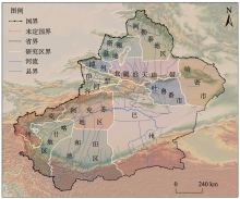
Fig. 1
Map of the study area"

Tab. 1
Weight, average, maximum required for calculation of disaster loss index"
| 统计量灾情要素 | 死亡人数/人 | 倒塌房屋数/间 | 倒塌棚圈数/座 | 牲畜死亡数量/头 | 农作物受灾面积/hm2 |
|---|---|---|---|---|---|
| 平均值 | 0.40 | 160.70 | 49.70 | 485.40 | 1170.50 |
| 最大值 | 35.00 | 6667.00 | 12000.00 | 70000.00 | 80000.00 |
| 无量纲累计值 | 39.00 | 77.60 | 13.30 | 22.30 | 47.10 |
| 权重 | 0.20 | 0.39 | 0.07 | 0.11 | 0.24 |
Tab. 2
Standard for classification of rainstorm and flood"
| 百分位数(r)/% | 灾损指数( | 危害性等级 |
|---|---|---|
| | | 一般(1级) |
| 50< | 0.21963< | 较重(2级) |
| 75< | 0.90931< | 严重(3级) |
| 90< | 2.33651< | 特重(4级) |
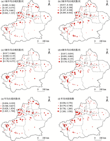
Fig. 2
Spatial distribution of average occurrence times and loss index of rainstorm flood disasters"


Fig. 3
Monthly variations of occurrence times, precipitation, occurrence days above rainstorm and occurrence days above heavy rain"
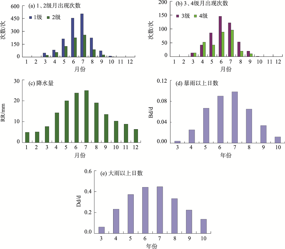

Fig. 4
Interannual change and mutation of occurrence times of rainstorm flood disaster"

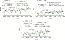
Fig. 5
Interannual variations of precipitations, days above rainstorm, days above heavy rain on March-October during 1961—2019"

Tab. 3
Correlation between annual occurrence times, annual disaster loss index and precipitation, days above heavy rain and days above rainstorm"
| 因变量 | 自变量 | 相关系数 | 信度 | 方程 |
|---|---|---|---|---|
| 年出现次数(Y) | 降水量(RR) | 0.6147 | 2.2×10⁻⁷ | Y=1.14RR-98.3 |
| 大雨以上日数(Dd) | 0.6299 | 9.0×10⁻⁸ | Y=47.40Dd-52.14 | |
| 暴雨以上日数(Bd) | 0.6028 | 4.4×10⁻⁷ | Y=156.02Bd-6.97 | |
| 年灾损指数(Zy) | 降水量(RR) | 0.4743 | 1.5×10⁻⁴ | Zy=1.33RR-122.85 |
| 大雨以上日数(Dd) | 0.5051 | 4.5×10⁻⁵ | Zy=57.17Dd-74.13 | |
| 暴雨以上日数(Bd) | 0.4912 | 7.8×10⁻⁵ | Zy=191.26Bd-20.87 |
| [1] | 王妮, 崔彩霞, 刘艳. 新疆暴雨洪涝灾害损失的时空特征及其影响因素[J]. 干旱区研究, 2020, 37(2):325-330. |
| [ Wang Ni, Cui Caixia, Liu Yan. Temporal spatial characteristica and the influencing factors of rainstorm flood disasters in Xinjiang[J]. Arid Zone Research, 2020, 37(2):325-330. ] | |
| [2] | 周月华, 彭涛, 史瑞琴. 我国暴雨洪涝灾害风险评估研究进展[J]. 暴雨灾害, 2019, 38(5):494-501. |
| [ Zhou Yuehua, Peng Tao, Shi Ruiqin. Research progress on risk assessment of heavy rainfall and flood disasters in China[J]. Torrential Rain and Disasters, 2019, 38(5):494-501. ] | |
| [3] | 于文金, 闫永刚, 吕海燕, 等. 基于GIS 的太湖流域暴雨洪涝灾害风险定量化研究[J]. 灾害学, 2011, 26(4):1-7. |
| [ Yu Wenjin, Yan Yonggang, Lü Haiyan, et al. GIS-based quantitative research on the risk of rainstorm and flood disaster in Taihu Basin[J]. Journal of Catastrophology, 2011, 26(4):1-7. ] | |
| [4] | 张菡, 郭翔, 王锐婷, 等. 四川省暴雨洪涝灾害风险区划研究[J]. 中国农学通报, 2013, 29(26):165-171. |
| [ Zhang Han, Guo Xiang, Wang Ruiting, et al. Research on rainstorm and flood disaster risk zoning in Sichuan Province[J]. Chinese Agricultural Science Bulletin, 2013, 29(26):165-171. ] | |
| [5] | 李梦婕, 汪明, 史培军. 湖南暴雨洪涝灾害损失时空特征及影响因素分析[J]. 北京师范大学学报(自然科学版), 2014, 50(4):429-434. |
| [ Li Mengjie, Wang Ming, Shi Peijun. Temporal-spatial distribution of rainstorm-flood disasters in Hunan, China and its affecting factors[J]. Journal of Beijing Normal University (Natural Science), 2014, 50(4):429-434. ] | |
| [6] | 杨帅, 苏筠. 县域暴雨洪涝灾害损失快速评估方法探讨——以湖南省为例[J]. 自然灾害学报, 2014, 23(5):156-163. |
| [ Yang Shuai, Su Yun. Exploration of rapid evaluation method for rainstorm flood losses at county level: A case study of Hunan Province[J]. Journal of Natural Disasters, 2014, 23(5):156-163. ] | |
| [7] | 李琳, 朱秀芳, 孙章丽, 等. 辽宁省暴雨洪涝灾害风险评估模型的建立与应用[J]. 北京师范大学学报(自然科学版), 2015, 51(增刊1):49-56. |
| [ Li Lin, Zhu Xiufang, Sun Zhangli, et al. Establishment and application of rainstorm-flood disaster risk assessment model in Liaoning Province[J]. Journal of Beijing Normal University (Natural Science), 2015, 51(Suppl. 1):49-56. | |
| [8] | 蔡嘉婧, 李晓明. 基于GIS 的德阳市暴雨洪涝灾害风险定量化研究[J]. 中国农学通报, 2016, 32(19):158-163. |
| [ Cai Jiajing, Li Xiaoming. Quantitative research on rainstorm & flood disaster in Deyang based on GIS[J]. Chinese Agricultural Science Bulletin, 2016, 32(19):158-163. ] | |
| [9] | 朱卫浩, 陈霞, 邵丽芳, 等. 基于格网的河北省精细化暴雨洪涝灾害风险区划[J]. 中国农学通报, 2016, 32(23):142-147. |
| [ Zhu Weihao, Chen Xia, Shao Lifang, et al. Refined risk zoning of storm and flood disaster in Hebei: Based on grid data[J]. Chinese Agricultural Science Bulletin, 2016, 32(23):142-147. ] | |
| [10] | 谢五三, 吴蓉, 田红, 等. 东津河流域暴雨洪涝灾害风险区划[J]. 气象, 2017, 43(3):341-347. |
| [ Xie Wusan, Wu Rong, Tian Hong, et al. Rainstorm flood risk regionalization of the Dongjin River Basin[J]. Meteorological Monthly, 2017, 43(3):341-347. ] | |
| [11] | 廖春贵, 熊小菊, 胡宝清. 基于GIS的广西暴雨洪涝灾害的时空特征与脆弱性评价[J]. 安徽农学通报, 2017, 23(5):29-33. |
| [ Liao Chungui, Xiong Xiaoju, Hu Baoqing. Spatial-temporal distribution and vulnerability assessment of flood disaster in Guangxi based on GIS[J]. Anhui Agricultural Science Bulletin, 2017, 23(5):29-33. ] | |
| [12] | 张杰, 吴明业. 基于GIS 的皖南地区暴雨洪涝灾害风险区划[J]. 中国农业资源与区划, 2017, 38(6):121-129. |
| [ Zhang Jie, Wu Mingye. Rainstorm and flood risk regionalization in southern Anhui Province based on GIS[J]. Chinese Journal of Agricultural Resources and Regional Planning, 2017, 38(6):121-129. ] | |
| [13] |
殷杰. 基于高精度地形表面模型的城市雨洪情景模拟与应急响应能力评价[J]. 地理研究, 2017, 36(6):1138-1146.
doi: 10.11821/dlyj201706011 |
|
[ Yin Jie. Urban pluvial flood scenario modeling and emergency response assessment using high resolution Lidar-DSM[J]. Geographical Research, 2017, 36(6):1138-1146. ]
doi: 10.11821/dlyj201706011 |
|
| [14] | 高超, 张正涛, 刘青, 等. 承灾体脆弱性评估指标的最优格网化方法——以淮河干流区暴雨洪涝灾害为例[J]. 自然灾害学报, 2018, 27(3):119-129. |
| [ Gao Chao, Zhang Zhengtao, Liu Qing, et al. Study on the optimal grid method in assessment of vulnerability to floods disaster: A case study in the mainstream of Huaihe River Basin[J]. Journal of Natural Disasters, 2018, 27(3):119-129. ] | |
| [15] | 杨昭明, 李万志, 冯晓莉, 等. 气候变暖背景下青海汛期暴雨洪涝及次生灾害风险评估[J]. 中国农学通报, 2019, 35(3):131-138. |
| [ Yang Zhaoming, Li Wanzhi, Feng Xiaoli, et al. Risk assessment of rainstorm flood and its secondary disasters during flood season in Qinghai under climate warming[J]. Chinese Agricultural Science Bulletin, 2019, 35(3):131-138. ] | |
| [16] | 李万志, 余迪, 冯晓莉, 等. 基于风险度的青海省暴雨洪涝灾害风险评估[J]. 冰川冻土, 2019, 41(3):680-688. |
| [ Li Wanzhi, Yu Di, Feng Xiaoli, et al. Risk assessment of rainstorm and flood disasters based on the hazard grades/indices in Qinghai Province[J]. Journal of Glaciology and Geocryology, 2019, 41(3):680-688. ] | |
| [17] | 解文欢, 张有智, 刘述彬. 农业洪涝灾害研究进展[J]. 中国农业资源与区划, 2020, 41(1):204-211. |
| [ Xie Wenhuan, Zhang Youzhi, Liu Shubin. Research progress on agricultural flood disasters[J]. Chinese Journal of Agricultural Resources and Regional Planning, 2020, 41(1):204-211. ] | |
| [18] | 姚俊英, 朱红蕊, 南极月, 等. 基于灰色理论的黑龙江省暴雨洪涝特征分析及灾变预测[J]. 灾害学, 2012, 27(1):59-63. |
| [ Yao Junying, Zhu Hongrui, Nan Jiyue, et al. Analysis of flood and disaster forecast in Heilongjiang Province based on grey theory[J]. Journal of Catastrophology, 2012, 27(1):59-63. ] | |
| [19] | 胡波, 丁烨毅, 何利德, 等. 基于模糊综合评价的宁波暴雨洪涝灾害风险区划[J]. 暴雨灾害, 2014, 33(4):380-385. |
| [ Hu Bo, Ding Yeyi, He Lide, et al. Risk division of rainstorm and water-logging disasters in Ningbo City based on fuzzy comprehensive evaluation[J]. Torrential Rain and Disasters, 2014, 33(4):380-385. ] | |
| [20] | 沈澄, 孙燕, 尹东屏, 等. 江苏省暴雨洪涝灾害特征分析[J]. 自然灾害学报, 2015, 24(2):203-212. |
| [ Shen Cheng, Sun Yan, Yin Dongping, et al. Characteristic analysis of rainstorm-induced flood disaster in Jiangsu Province[J]. Journal of Natural Disasters, 2015, 24(2):203-212. ] | |
| [21] | 温泉沛, 周月华, 霍治国, 等. 气候变暖背景下东南地区暴雨洪涝灾害风险变化[J]. 生态学杂志, 2017, 36(2):483-490. |
| [ Wen Quanpei, Zhou Yuehua, Huo Zhiguo, et al. Risk changes of storm flood disasters in southeast China under climatic warming[J]. Chinese Journal of Ecology, 2017, 36(2):483-490. ] | |
| [22] | 温泉沛, 周月华, 霍治国, 等. 湖北暴雨洪涝灾害脆弱性评估的定量研究[J]. 中国农业气象, 2018, 39(8):547-557. |
| [ Wen Quanpei, Zhou Yuehua, Huo Zhiguo, et al. Quantitative assessment on vulnerability of storm flood disasters in Hubei Province[J]. Chinese Journal of Agrometeorology, 2018, 39(8):547-557. ] | |
| [23] | 赵珊珊, 高歌, 黄大鹏, 等. 2004—2013年中国气象灾害损失特征分析[J]. 气象与环境学报, 2017, 33(1):101-107. |
| [ Zhao Shanshan, Gao Ge, Huang Dapeng, et al. Characteristics of meteorological disaster losses in China from 2004 to 2013[J]. Journal of Meteorology and Environment, 2017, 33(1):101-107. ] | |
| [24] | 韩兰英, 张强, 杨阳, 等. 气候变化背景下甘肃省主要气象灾害综合损失特征[J]. 干旱区资源与环境, 2019, 33(7):107-114. |
| [ Han Lanying, Zhang Qiang, Yang Yang, et al. Change characteristics of meteorological disaster losses under climatic change in Gansu Province[J]. Journal of Arid Land Resources and Environment, 2019, 33(7):107-114. ] | |
| [25] | 王旭, 储长江, 牟欢. 新疆雪灾空间格局和年际变化特征分析[J]. 干旱区研究, 2020, 37(6):1488-1495. |
| [ Wang Xu, Chu Chang-jiang, Mu Huan. Spatial pattern and interannual variation characteristics of snow disaster in Xinjiang[J]. Arid Zone Research, 2020, 37(6):1488-1495. ] | |
| [26] | 贾俊平. 统计学[M]. 北京: 清华大学出版社, 2004: 68-71. |
| [ Jia Junping. Statistics[M]. Beijing: Tsinghua University Press, 2004: 68-71. ] | |
| [27] | 王昀, 谢向阳, 马禹, 等. 天山北侧成灾雹云移动路径及预警指标的研究[J]. 干旱区地理, 2017, 40(6):1152-1164. |
| [ Wang Yun, Xie Xiangyang, Ma Yu, et al. Moving paths and nowcasting indicators of radar of hail cloud in northern Tianshan Mountains[J]. Arid Land Geography, 2017, 40(6):1152-1164. ] | |
| [28] | 赵清波, 李莉. 利用原始资料计算百分位数的方法[J]. 中国卫生统计, 1999, 3(16):185. |
| [ Zhao Qingbo, Li Li. Method of calculating percentiles using raw data[J]. Health Statistics in China, 1999, 3(16):185. ] | |
| [29] |
Zhai P M, Zhang X B, Wan H, et al. Trends in total precipitation and frequency of daily precipitation extremes over China[J]. Journal of Climate, 2005, 18(7):1096-1108.
doi: 10.1175/JCLI-3318.1 |
| Viewed | ||||||||||||||||||||||||||||||||||||||||||||||||||
|
Full text 944
|
|
|||||||||||||||||||||||||||||||||||||||||||||||||
|
Abstract 733
|
|
|||||||||||||||||||||||||||||||||||||||||||||||||
Cited |
|
|||||||||||||||||||||||||||||||||||||||||||||||||
| Shared | ||||||||||||||||||||||||||||||||||||||||||||||||||
|
||