Arid Land Geography ›› 2022, Vol. 45 ›› Issue (4): 1268-1280.doi: 10.12118/j.issn.1000-6060.2021.465
• Regional Development • Previous Articles Next Articles
YU Yuyang1,2( ),LI Jing1(),ZHOU Zixiang3,TANG Chengyan1
Received:2021-10-11
Revised:2021-12-18
Online:2022-07-25
Published:2022-08-11
Contact:
Jing LI
E-mail:yuyuyangg@qq.com;lijing@snnu.edu.cn
YU Yuyang,LI Jing,ZHOU Zixiang,TANG Chengyan. Spatial pattern optimization of ecosystem services based on Bayesian networks: A case of the Jing River Basin[J].Arid Land Geography, 2022, 45(4): 1268-1280.
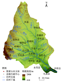
Fig. 1
Overview of the study area"

Tab. 1
Data sources"
| 数据类型 | 数据描述 | 数据来源 |
|---|---|---|
| 基础地理信息数据 | 行政区划、河流、道路等 | 国家基础地理信息中心( |
| 高程数据 | 来源于地理空间数据云,空间分辨率为30 m | 地理空间数据云( |
| 土壤数据 | 第二次全国土地调查南京土壤研究所提供的1:100000土壤数据,空间分辨率为1 km×1 km | 国家青藏高原科学数据中心( |
| 土地利用数据 | 来源于GlobalLand 30,全球地理信息公共产品,空间分辨率为30 m | 全球地理信息公共产品( |
| 气象数据 | 2000—2020年逐日数据,指标包括降水量、最高气温、最低气温、风速、相对湿度数据 | 国家气象科学数据中心( |
| 水文数据 | 2000—2020年张家山水文站逐日径流数据 | 张家山水文站( |
| 统计数据 | 2000—2020年人口密度以及GDP等统计数据 | 统计年鉴 |
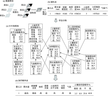
Fig. 2
Schematic diagram of Bayesian belief network construction for farmland ecosystem service"

Tab. 2
State classification of factors"
| 因子 | 状态名称 | 实际值范围 |
|---|---|---|
| 蒸散发量/mm | 低 | 2256~3903 |
| 中 | 3903~5362 | |
| 高 | 5362~9827 | |
| 最高 | 9827~65534 | |
| 土地利用水平分级 | 低 | 1 |
| 中 | 2 | |
| 高 | 3 | |
| 最高 | 4 | |
| 植被覆盖度 | 低 | -0.17~0.14 |
| 中 | 0.14~0.30 | |
| 高 | 0.30~0.46 | |
| 最高 | 0.46~0.70 | |
| 水土保持措施因素 | 低 | 0.00 |
| 中 | 0.00~0.10 | |
| 高 | 0.10~0.35 | |
| 最高 | 0.35~1.00 | |
| 土壤类型 | 低 | 1~4 |
| 中 | 4~9 | |
| 高 | 9~14 | |
| 最高 | 14~20 | |
| 太阳辐射/MJ·m-2 | 低 | 4989~5331 |
| 中 | 5331~5576 | |
| 高 | 5576~5732 | |
| 最高 | 5732~5911 | |
| 降水量/mm | 低 | 323~422 |
| 中 | 422~506 | |
| 高 | 506~584 | |
| 最高 | 584~693 | |
| 坡度/(°) | 低 | 0.00~3.50 |
| 中 | 3.50~7.00 | |
| 高 | 7.00~10.50 | |
| 气温/℃ | 低 | <8 |
| 中 | 8~9 | |
| 高 | 9~10 | |
| 最高 | 10~12 | |
| 土地利用类型 | 耕地 | - |
| 林地 | - | |
| 草地 | - | |
| 水域 | - | |
| 建设用地 | - | |
| 未利用地 | - | |
| 土壤保持/t·hm-2 | 低 | 0.00~41.30 |
| 中 | 41.30~93.60 | |
| 高 | 93.60~174.14 | |
| 最高 | 174.14~555.09 | |
| 农业生产力/t·hm-2 | 低 | 28.64~57.75 |
| 中 | 57.75~60.00 | |
| 高 | 60.00~90.00 | |
| 最高 | 90.00~120.00 | |
| NPP/g C·m-2 | 低 | 0.23~11.97 |
| 中 | 11.97~135.89 | |
| 高 | 135.89~204.47 | |
| 最高 | 204.47~388.90 | |
| 产水量/m3 | 低 | 0.00~408.61 |
| 中 | 408.61~1001.75 | |
| 高 | 1001.75~2095.70 | |
| 最高 | 2095.70~3361.15 |
Tab. 3
Sensitivity analysis result of parameters"
| 参数名称 | 相对显著性(T) | 显著性检验(P) | 参数范围 | 最优校准值 |
|---|---|---|---|---|
| 土壤饱和导水率 | 2.5450 | 0.0112 | -0.9~0.9 | -0.8425 |
| 降雪温度 | -2.2385 | 0.0256 | -20~20 | 7.9700 |
| 主河道水力传导度 | 1.8577 | 0.0638 | 0~150 | 58.8517 |
| 地下水滞留系数 | -1.7717 | 0.0771 | 0~500 | 390.1691 |
| 土壤蒸发补偿系数 | -1.2422 | 0.2148 | 0.01~1.00 | 0.0294 |
| 土壤有效含水率 | -1.1148 | 0.2655 | -0.5~0.5 | 0.3959 |
| 土壤湿密度 | 1.0494 | 0.2945 | -0.5~0.5 | -0.4496 |
| 基流系数 | 0.5965 | 0.5512 | 0~1 | 0.9276 |
| 地下水再蒸发系数 | -0.5050 | 0.6138 | 0.02~0.20 | 0.1400 |
| 浅层地下水径流系数 | 0.0329 | 0.9737 | 0~5000 | 2409.2715 |
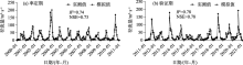
Fig. 3
Simulated and measured values of monthly runoff during the regular period and the verification period"

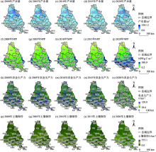
Fig. 4
Change and distribution of ecosystem services in Jing River Basin"

Tab. 4
Conditional probability of the node crop production"
| 土地利用水平 | 蒸散发量 | 农业生产力 | |||
|---|---|---|---|---|---|
| 最高 | 高 | 中 | 低 | ||
| 最高 | 最高 | 0.353 | 0.002 | 0.284 | 0.361 |
| 高 | 高 | 0.229 | 0.032 | 0.620 | 0.119 |
| 中 | 高 | 0.099 | 0.111 | 0.299 | 0.491 |
| 低 | 中 | 0.108 | 0.422 | 0.282 | 0.188 |
Tab. 5
Conditional probability of the node water yield"
| 土地利用水平 | 降水量 | 气温 | 土地利用类型 | 产水量 | |||
|---|---|---|---|---|---|---|---|
| 最高 | 高 | 中 | 低 | ||||
| 最高 | 最高 | 高 | 未利用地 | 0.159 | 0.020 | 0.205 | 0.616 |
| 中 | 最高 | 低 | 未利用地 | 0.065 | 0.138 | 0.579 | 0.217 |
| 中 | 最高 | 低 | 草地 | 0.031 | 0.805 | 0.084 | 0.080 |
| 最高 | 最高 | 最高 | 草地 | 0.488 | 0.124 | 0.191 | 0.196 |
Tab. 6
Conditional probability of the node NPP"
| 降水量 | 气温 | 土地利用类型 | 太阳辐射 | 植被覆盖度 | NPP | |||
|---|---|---|---|---|---|---|---|---|
| 最高 | 高 | 中 | 低 | |||||
| 中 | 最高 | 未利用地 | 最高 | 最高 | 0.060 | 0.024 | 0.878 | 0.039 |
| 低 | 低 | 未利用地 | 低 | 低 | 0.072 | 0.043 | 0.438 | 0.446 |
| 中 | 最高 | 草地 | 最高 | 最高 | 0.149 | 0.469 | 0.019 | 0.363 |
| 最高 | 最高 | 耕地 | 最高 | 最高 | 0.571 | 0.154 | 0.160 | 0.115 |
Tab. 7
Conditional probability of the node soil conservation"
| 土壤类型 | 降水量 | 植被覆盖度 | 坡度 | 土壤保持措施因素 | 土壤保持 | |||
|---|---|---|---|---|---|---|---|---|
| 最高 | 高 | 中 | 低 | |||||
| 最高 | 最高 | 中 | 低 | 最高 | 0.126 | 0.056 | 0.320 | 0.499 |
| 最高 | 最高 | 最高 | 低 | 最高 | 0.191 | 0.135 | 0.458 | 0.215 |
| 最高 | 最高 | 最高 | 中 | 高 | 0.108 | 0.496 | 0.035 | 0.362 |
| 中 | 中 | 最高 | 中 | 中 | 0.824 | 0.007 | 0.139 | 0.029 |
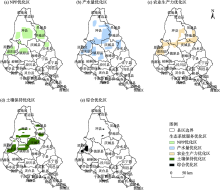
Fig. 5
Integrated ecosystem service optimization zone"

| [1] | Fu B J. Trade-off analyses and synthetic integrated method of multiple ecosystem[J]. Resources Science, 2016, 38(1): 5-10. |
| [2] |
Pedreschi D, Bouch P, Moriary M, et al. Integrated ecosystem analysis in Irish waters: Providing the context for ecosystem-based fisheries management[J]. Fisheries Research, 2019, 209: 218-229.
doi: 10.1016/j.fishres.2018.09.023 |
| [3] |
Newton A, Brito A C, Icely J D, et al. Assessing, quantifying and valuing the ecosystem services of coastal lagoons[J]. Journal for Nature Conservation, 2018, 44: 50-65.
doi: 10.1016/j.jnc.2018.02.009 |
| [4] |
Chen L C, Guan X, Li H M, et al. Spatiotemporal patterns of carbon storage in forest ecosystems in Hunan Province, China[J]. Forest Ecology and Management, 2019, 432: 656-666.
doi: 10.1016/j.foreco.2018.09.059 |
| [5] |
Luisetti T, Turner R K, Andrews J E, et al. Quantifying and valuing carbon flows and stores in coastal and shelf ecosystems in the UK[J]. Ecosystem Services, 2019, 35: 67-76.
doi: 10.1016/j.ecoser.2018.10.013 |
| [6] | Stritih A, Bebi P, Grêt-Regamey A. Quantifying uncertainties in earth observation-based ecosystem service assessments[J]. Environmental Modelling & Software, 2019, 111: 300-310. |
| [7] |
戴尔阜, 王晓莉, 朱建佳, 等. 生态系统服务权衡: 方法、模型与研究框架[J]. 地理研究, 2016, 35(6): 1005-1016.
doi: 10.11821/dlyj201606001 |
|
[ Dai Erfu, Wang Xiaoli, Zhu Jianjia, et al. Methods, tools and research framework of ecosystem service trade-offs[J]. Geographical Research, 2016, 35(6): 1005-1016. ]
doi: 10.11821/dlyj201606001 |
|
| [8] |
傅伯杰, 于丹丹. 生态系统服务权衡与集成方法[J]. 资源科学, 2016, 38(1): 1-9.
doi: 10.18402/resci.2016.01.01 |
|
[ Fu Bojie, Yu Dandan. Trade-off analyses and synthetic integrated method of multiple ecosystem services[J]. Resources Science, 2016, 38(1): 1-9. ]
doi: 10.18402/resci.2016.01.01 |
|
| [9] | 李婷, 李晶, 王彦泽, 等. 关中天水经济区生态系统固碳服务空间流动及格局优化[J]. 中国农业科学, 2017, 50(20): 3953-3969. |
| [ Li Ting, Li Jing, Wang Yanze, et al. The spatial flow and pattern optimization of carbon sequestration ecosystem service in Guanzhong Tianshui economical region[J]. Scientia Agricultura Sinica, 2017, 50(20): 3953-3969. ] | |
| [10] | 刘维, 周忠学, 郎睿婷. 城市绿色基础设施生态系统服务供需关系及空间优化--以西安市为例[J]. 干旱区地理, 2021, 44(5): 1500-1513. |
| [ Liu Wei, Zhou Zhongxue, Lang Ruiting. Supply-demand relations of ecosystem services of urban green infrastructure and its spatial optimization: A case of Xi’an City[J]. Arid Land Geography, 2021, 44(5): 1500-1513. ] | |
| [11] |
Dai F N, Quinn C, Morari F. A Bayesian belief network framework to predict SOC dynamics of alternative management scenarios[J]. Soil and Tillage Research, 2018, 179: 114-124.
doi: 10.1016/j.still.2018.01.002 |
| [12] |
Wu X, Wang S, Fu B J, et al. Land use optimization based on ecosystem service assessment: A case study in the Yanhe watershed[J]. Land Use Policy, 2018, 72: 303-312.
doi: 10.1016/j.landusepol.2018.01.003 |
| [13] |
傅伯杰, 张立伟. 土地利用变化与生态系统服务: 概念、方法与进展[J]. 地理科学进展, 2014, 33(4): 441-446.
doi: 10.11820/dlkxjz.2014.04.001 |
|
[ Fu Bojie, Zhang Liwei. Land-use change and ecosystem services: Concepts, methods and progress[J]. Progress in Geography, 2014, 33(4): 441-446. ]
doi: 10.11820/dlkxjz.2014.04.001 |
|
| [14] | 谢高地, 张彩霞, 张昌顺, 等. 中国生态系统服务的价值[J]. 资源科学, 2015, 37(9): 1740-1746. |
| [ Xie Gaodi, Zhang Caixia, Zhang Changshun, et al. The value of ecosystem services in China[J]. Resources Science, 2015, 37(9): 1740-1746. ] | |
| [15] | 肖玉, 谢高地, 鲁春霞, 等. 基于供需关系的生态系统服务空间流动研究进展[J]. 生态学报, 2016, 36(10): 3096-3102. |
| [ Xiao Yu, Xie Gaodi, Lu Chunxia, et al. Involvement of ecosystem service flows in human wellbeing based on the relationship between supply and demand[J]. Acta Ecologica Sinica, 2016, 36(10): 3096-3102. ] | |
| [16] |
龚建周, 刘彦随, 张灵. 广州市土地利用结构优化配置及其潜力[J]. 地理学报, 2010, 65(11): 1391-1400.
doi: 10.11821/xb201011009 |
|
[ Gong Jianzhou, Liu Yansui, Zhang Ling. The optimal allocation of land use and its potential appraisal in Guangzhou City[J]. Acta Geographica Sinica, 2010, 65(11): 1391-1400. ]
doi: 10.11821/xb201011009 |
|
| [17] | 刘慧灵, 伍世代, 韦素琼, 等. 基于低碳经济导向的土地利用结构优化研究--以福建省福州市为例[J]. 水土保持通报, 2017, 37(6): 202-208. |
| [ Zhang Huiling, Wu Shidai, Wei Suqiong, et al. Optimization research of low-carbon economy oriented land use structure: A case study in Fuzhou City of Fujian Province[J]. Bulletin of Soil and Water Conservation, 2017, 37(6): 202-208. ] | |
| [18] | 王观湧, 张乐, 于化龙, 等. 基于生态安全的土地利用结构优化研究[J]. 土壤通报, 2015, 46(6): 1322-1327. |
| [ Wang Guanyong, Zhang Le, Yu Hualong, et al. Research on optimization of land use structure in Baoding urban agglomeration based on ecological security[J]. Chinese Journal of Soil Science, 2015, 46(6): 1322-1327. ] | |
| [19] | 向芸芸, 蒙吉军. 基于生态效益的武汉城市圈土地利用结构优化[J]. 长江流域资源与环境, 2013, 22(10): 1297-1304. |
| [ Xiang Yunyun, Meng Jijun. Research on optimization of land use structure in Wuhan urban agglomeration based on ecological security benefit[J]. Resources and Environment in the Yangtze Basin, 2013, 22(10): 1297-1304. ] | |
| [20] | 李秀霞, 徐龙, 江恩赐. 基于系统动力学的土地利用结构多目标优化[J]. 农业工程学报, 2013, 29(16): 247-254. |
| [ Li Xiuxia, Xu Long, Jiang Enci. Multi-objective optimization of land use structure in western Jilin Province based on system dynamics[J]. Transactions of the Chinese Society of Agricultural Engineering, 2013, 29(16): 247-254. ] | |
| [21] |
Landuyt D, Broekx S, Goethals P L M. Bayesian belief networks to analyse trade-offs among ecosystem services at the regional scale[J]. Ecological Indicators, 2016, 71: 327-335.
doi: 10.1016/j.ecolind.2016.07.015 |
| [22] |
曾莉, 李晶, 李婷, 等. 基于贝叶斯网络的水源涵养服务空间格局优化[J]. 地理学报, 2018, 73(9): 1809-1822.
doi: 10.11821/dlxb201809015 |
|
[ Zeng Li, Li Jing, Li Ting, et al. Optimizing spatial patterns of water conservation ecosystem service based on Bayesian belief networks[J]. Acta Geographica Sinica, 2018, 73(9): 1809-1822. ]
doi: 10.11821/dlxb201809015 |
|
| [23] |
Fox W E, Medina-Cetina Z, Angerer J, et al. Water quality & natural resource management on military training lands in central Texas: Improved decision support via Bayesian networks[J]. Sustainability of Water Quality and Ecology, 2017, 9-10: 39-52.
doi: 10.1016/j.swaqe.2017.03.001 |
| [24] |
Landuyt D, Lemmens P, D’hondt R, et al. An ecosystem service approach to support integrated pond management: A case study using Bayesian belief networks-highlighting opportunities and risks[J]. Journal of Environmental Management, 2014, 145: 79-87.
doi: 10.1016/j.jenvman.2014.06.015 pmid: 25005053 |
| [25] |
Dang K B, Windhorst W, Burkhard B, et al. A Bayesian belief network: Based approach to link ecosystem functions with rice provisioning ecosystem services[J]. Ecological Indicators, 2019, 100: 30-44.
doi: 10.1016/j.ecolind.2018.04.055 |
| [26] |
Chen C, Xie G, Zhen L, et al. Analysis on Jinghe River watershed vegetation dynamics and evaluation on its relation with precipitation[J]. Acta Ecologica Sinica, 2008, 28(3): 925-938.
doi: 10.1016/S1872-2032(08)60032-3 |
| [27] | Xie G D, Zhen L, Chen C, et al. The changes and their interactions of precipitation-landscape-runoff in Jinghe Watershed[J]. Resources Science, 2007, 29(2): 156-163. |
| [28] | Guo A, Chang J, Wang Y, et al. Variation characteristics of rainfall-run relationship and driving factors analysis in Jinghe River Basin in nearly 50 years[J]. Transactions of the Chinese Society of Agricultural Engineering, 2015, 31(14): 165-171. |
| [29] | 甄霖, 谢高地, 杨丽, 等. 基于参与式社区评估法的泾河流域景观管理问题分析[J]. 中国人口·资源与环境, 2007, 17(3): 129-133. |
| [ Zhen Lin, Xie Gaodi, Yang Li, et al. Challenges facing landscape management in the Jinghe watershed of northwest China by using participatory rual apprise[J]. China Population, Resources and Environment, 2007, 17(3): 129-133. ] | |
| [30] | 麻馨月, 杨洋, 娄成武. 21世纪以来环渤海地区耕地生产潜力时空动态[J]. 中国人口·资源与环境, 2016, 26(增刊1): 226-231. |
| [ Ma Xinyue, Lou Chengwu. Spatiotemporal dynamics of cultivated land potential productivity in Bohai Rim since the 21st Century[J]. China Population, Resources and Environment, 2016, 26(Suppl. 1): 226-231. ] | |
| [31] |
Zheng Z, Fu B J, Hu H, et al. A method to identify the variable ecosystem services relationship across time: A case study on Yanhe Basin, China[J]. Landscape Ecology, 2014, 29(10): 1689-1696.
doi: 10.1007/s10980-014-0088-x |
| [32] | Neitsch S L, Arnold J G, Kiniry J R, et al. Soil and water assessment tool, theoretical documentation, Version 2000[M]. College Station, Texas: Texas Water Resources Institute, 2002. |
| [33] |
杨晓楠, 李晶, 秦克玉, 等. 关中天水经济区生态系统服务的权衡关系[J]. 地理学报, 2015, 70(11): 1762-1773.
doi: 10.11821/dlxb201511006 |
|
[ Yang Xiaonan, Li Jing, Qin Keyu, et al. Trade-offs between ecosystem services in Guanzhong Tianshui Economic Region[J]. Acta Geographica Sinica, 2015, 70(11): 1762-1773. ]
doi: 10.11821/dlxb201511006 |
|
| [34] |
朱文泉, 潘耀忠, 张锦水. 中国陆地植被净初级生产力遥感估算[J]. 植物生态学报, 2007, 31(3): 413-424.
doi: 10.17521/cjpe.2007.0050 |
|
[ Zhu Wenquan, Pan Yaozhong, Zhang Jinshui. Estimation of net primary productivity of Chinese terrestrial vegetation based on remote sensing[J]. Chinese Journal of Plant Ecology, 2007, 31(3): 413-424. ]
doi: 10.17521/cjpe.2007.0050 |
|
| [35] |
Peng H, Jia Y, Niu C, et al. Eco-hydrological simulation of soil and water conservation in the Jinghe River Basin in the Loess Plateau, China[J]. Journal of Hydro-environment Research, 2015, 9(3): 452-464.
doi: 10.1016/j.jher.2014.09.003 |
| [36] | Wischmeier W H, Smith D D. Predicting rainfall-erosion losses:A guide to conservation planning, agricultural handbook No.537[M]. Washington DC: US Department of Agriculture, 1978. |
| [37] | 李硕豪, 张军. 贝叶斯网络结构学习综述[J]. 计算机应用研究, 2015, 32(3): 641-646. |
| [ Li Shuohao, Zhang Jun. Review of Bayesian networks structure learning[J]. Application Research of Computers, 2015, 32(3): 641-646. ] | |
| [38] |
Macpherson M P, Webb E B, Raedeke A, et al. A review of Bayesian belief network models as decision-support tools for wetland conservation: Are water bird’s potential umbrella taxa?[J]Biological Conservation, 2018, 226: 215-223.
doi: 10.1016/j.biocon.2018.08.001 |
| [39] | Salliou N, Barnaud C, Vialatie A, et al. A participatory Bayesian belief network approach to explore ambiguity among stakeholders about socio-ecological systems[J]. Environmental Modelling & Software, 2017, 96: 199-209. |
| [40] |
Dai W, Fu W, Jiang P, et al. Spatial pattern of carbon stocks in forest ecosystems of a typical subtropical region of southeastern China[J]. Forest Ecology and Management, 2018, 409: 288-297.
doi: 10.1016/j.foreco.2017.11.036 |
| [41] |
Kleemann J, Celio E, Nyarko B K, et al. Assessing the risk of seasonal food insecurity with an expert-based Bayesian belief network approach in northern Ghana, West Africa[J]. Ecological Complexity, 2017, 32: 53-73.
doi: 10.1016/j.ecocom.2017.09.002 |
| [42] |
李晶, 周自翔. 延河流域景观格局与生态水文过程分析[J]. 地理学报, 2014, 69(7): 933-944.
doi: 10.11821/dlxb201407006 |
|
[ Li Jing, Zhou Zixiang. Landscape pattern and hydrological processes in Yanhe River Basin of China[J]. Acta Geographica Sinica, 2014, 69(7): 933-944. ]
doi: 10.11821/dlxb201407006 |
|
| [43] | Jiang Y, Wang L, Wei X, et al. Impacts of climate change on runoff of Jinghe River based on SWAT model[J]. Transactions of the Chinese Society for Agricultural Machinery, 2017, 48(2): 262-270. |
| [44] | 刘宇, 管子隆, 田济扬, 等. 近70a泾河流域径流变化及其驱动因素研究[J]. 干旱区地理, 2022, 45(1): 17-26. |
| [ Liu Yu, Guan Zilong, Tian Jiyang, et al. Study on runoff change and its driving factors in Jinghe River Basin in recent 70 years[J]. Arid Land Geography, 2022, 45(1): 17-26. ] | |
| [45] | 黄晨璐, 杨勤科. 渭河与泾河流域水沙变化规律及其差异性分析[J]. 干旱区地理, 2021, 44(2): 327-336. |
| [ Huang Chenlu, Yang Qinke. Runoff and sediment variation rules and differences in Wei River and Jing River Basins[J]. Arid Land Geography, 2021, 44(2): 327-336. ] | |
| [46] | 卞鸿雁, 庞奖励, 任志远. 泾河流域固碳释氧功能的时空动态测评[J]. 陕西师范大学学报(自然科学版), 2013, 41(2): 94-99. |
| [ Bian Hongyan, Pang Jiangli, Ren Zhiyuan. The spatial and temporal changes of carbon fixation and oxygen release in Jinghe River Basin[J]. Journal of Shaanxi Normal University (Natural Science Edition), 2013, 41(2): 94-99. ] | |
| [47] |
Zheng T, Zhou Z, Zou Y, et al. Analysis of spatial and temporal characteristics and spatial flow process of soil conservation service in Jinghe Basin of China[J]. Sustainability, 2021, 13(4): 1794, doi: 10.3390/su13041794.
doi: 10.3390/su13041794 |
| [48] | 杨莉, 甄霖, 李芬, 等. 黄土高原生态系统服务变化对人类福祉的影响初探[J]. 资源科学, 2010, 32(5): 849-855. |
| [ Yang Li, Zeng Lin, Li Fen, et al. Impacts of ecosystem services change on human well-being in the Loess Plateau[J]. Resources Science, 2010, 32(5): 849-855. ] | |
| [49] |
Olschewski R, Benítez P C. Optimizing joint production of timber and carbon sequestration of afforestation projects[J]. Journal of Forest Economics, 2010, 16(1): 1-10.
doi: 10.1016/j.jfe.2009.03.002 |
| [50] |
Hoover C M, Heath L S. Potential gains in C storage on productive forestlands in the northeastern United States through stocking management[J]. Ecological Applications, 2011, 21: 1154-1161.
doi: 10.1890/10-0046.1 |
| [51] | Chen S H, Pollino C A. Good practice in Bayesian network modelling[J]. Environmental Modelling & Software, 2012, 37(17): 134-145. |
|
||