Arid Land Geography ›› 2021, Vol. 44 ›› Issue (5): 1396-1406.doi: 10.12118/j.issn.1000–6060.2021.05.20
• Earth Information Sciences • Previous Articles Next Articles
ZHAO Xiaofeng1,2,3,4( ),WANG Jinlin1,2,3,4(),WANG Shanshan1,2,3,4,WANG Quan5
Received:2020-09-22
Revised:2020-11-10
Online:2021-09-25
Published:2021-09-22
Contact:
Jinlin WANG
E-mail:464592044@qq.com;wangjinlin@ms.xjb.ac.cn
ZHAO Xiaofeng,WANG Jinlin,WANG Shanshan,WANG Quan. Changes of ecological security pattern in Kalamaili region based on MCR models[J].Arid Land Geography, 2021, 44(5): 1396-1406.
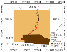
Fig. 1
Schematic diagram of the study area"

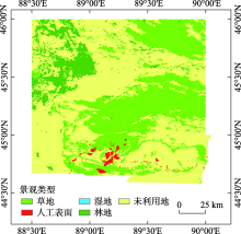
Fig. 2
Forecast of Kalamaili region landscape pattern in 2025"

Tab. 1
Habitat identification index system"
| 栖息地指标 | 适宜(1) | 次适宜(3) | 低适宜(5) | 不适宜(7) |
|---|---|---|---|---|
| 距水源点距离(A1)/km | <5 | 5~15 | - | >15 |
| 坡度(A2)/(°) | 0~5 | 5~15 | - | >15 |
| 植被类型(A3) | 高 | 中 | 低 | - |
| 土壤类型(A4) | - | - | - | 风沙土 |
| 景观类型(A5) | 草地 | 未利用地 | 林地 | 人工表面、湿地 |
| 距G216距离(A6)/m | >1200 | 601~1200 | 400~600 | <400 |
| 距高速公路、铁路距离(A7)/m | >1200 | 601~1200 | 400~600 | <400 |
| 距经济区距离(A8)/m | >5000 | 4001~5000 | 2001~4000 | <2000 |
| 距矿点距离(A9)/m | >5000 | 4001~5000 | 2001~4000 | <2000 |
Tab. 2
Weight of each identification indicator"
| 年份 | A1 | A2 | A3 | A4 | A5 | A6 | A7 | A8 | A9 |
|---|---|---|---|---|---|---|---|---|---|
| 1990—2000 | 0.4160 | 0.0899 | 0.1873 | 0.0386 | 0.1001 | 0.0504 | - | 0.1178 | - |
| 2010—2015 | 0.3467 | 0.0843 | 0.1561 | 0.0322 | 0.0868 | 0.0403 | - | 0.0699 | 0.1932 |
| 2019—2025 | 0.3900 | 0.0843 | 0.1756 | 0.0362 | 0.0887 | 0.0429 | 0.0912 | 0.0912 | - |
Fig. 3
Source site changes in Kalamaili Reserve"

Tab. 3
Ecological safety resistance factors"
| 阻力值 | 10 | 30 | 50 | 100 |
|---|---|---|---|---|
| 保护区区划(B1) | 核心区 | 缓冲区 | 实验区 | 开发区 |
| 景观类型(B2) | 草地 | 未利用地 | 林地 | 人工表面、湿地 |
| 距道路距离(B3)/m | >1200 | 601~1200 | 400~600 | <400 |
Tab. 4
Weight of resistance factors"
| 年份 | B1 | B2 | B3 |
|---|---|---|---|
| 1990—2000 | - | 0.6667 | 0.3333 |
| 2010—2025 | 0.4373 | 0.3992 | 0.1635 |

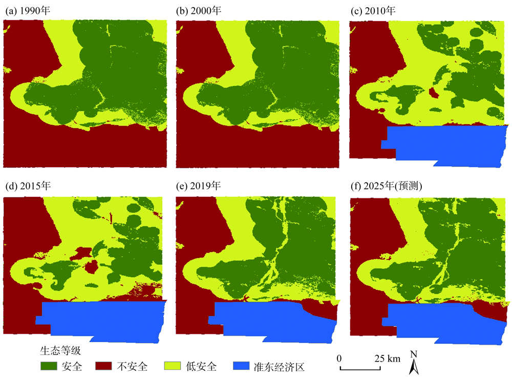
Fig. 4
Ecological security pattern of Kalamaili Reserve"
Tab. 5
Area of ecological safety classification /km2"
| 生态等级 | 1990年 | 2000年 | 2010年 | 2015年 | 2019年 | 2025年 |
|---|---|---|---|---|---|---|
| 安全 | 7438.64 | 7439.00 | 3831.63 | 3237.31 | 6265.91 | 6421.88 |
| 低安全 | 3182.42 | 3182.77 | 6258.13 | 6143.12 | 3863.57 | 3741.25 |
| 不安全 | 8199.04 | 8198.34 | 4214.41 | 4918.49 | 4616.66 | 4583.73 |
| [1] | 苏芳, 宋妮妮, 马静, 等. 生态脆弱区居民环境意识的影响因素研究--以甘肃省为例[J]. 干旱区资源与环境, 2020, 34(5):9-14. |
| [ Su Fang, Song Nini, Ma Jing, et al. Factors influencing the residents’ environmental awareness in ecologically fragile areas of Gansu Province[J]. Journal of Arid Land Resources and Environment, 2020, 34(5):9-14. ] | |
| [2] | 卢艳丽, 丁四保, 王荣成, 等. 生态脆弱地区的区域外部性及其可持续发展[J]. 中国人口·资源与环境, 2010, 20(7):68-73. |
| [ Lu Yanli, Ding Sibao, Wang Rongcheng, et al. Sustainable development of vulnerable ecological regions under the perspective of regional externalities[J]. China Population Resources and Environment, 2010, 20(7):68-73. ] | |
| [3] | 俞孔坚. 生物保护的景观生态安全格局[J]. 生态学报, 1999(1):10-17. |
| [ Yu Kongjian. Landscape ecological security patterns in biological conservation[J]. Acta Ecological Sinica, 1999(1):10-17. ] | |
| [4] | 杨亮洁, 王晶, 魏伟, 等. 干旱内陆河流域生态安全格局的构建及优化--以石羊河流域为例[J]. 生态学报, 2020, 40(17):5915-5927. |
| [ Yang Liangjie, Wang Jing, Wei Wei, et al. Ecological security pattern construction and optimization in arid inland river basin: A case study of Shiyang River Basin[J]. Acta Ecological Sinica, 2020, 40(17):5915-5927. ] | |
| [5] | 郭利刚, 冯珍珍, 刘庚, 等. 基于物元模型的汾河流域土地生态安全评价[J]. 生态学杂志, 2020, 39(6):2061-2069. |
| [ Guo Ligang, Feng Zhenzhen, Liu Geng, et al. Evaluation of land eco-security in Fenhe River Basin based on matter-element model[J]. Chinese Journal of Ecology, 2020, 39(6):2061-2069. ] | |
| [6] | 马轩凯, 高敏华. 西北干旱地区绿洲城市土地生态安全动态评价--以新疆库尔勒市为例[J]. 干旱区地理, 2017, 40(1):172-180. |
| [ Ma Xuankai, Gao Minhua. Dynamic assessment of land ecologic safety of oasis city in arid northwest China: A case of Korla City in Xinjiang[J]. Arid Land Geography, 2017, 40(1):172-180. ] | |
| [7] | 张丽芳, 廖雨, 杨存建, 等. 基于景观安全格局理论的寿城自然保护区人类活动用地评价[J]. 水土保持通报, 2019, 39(6):217-222. |
| [ Zhang Lifang, Liao Yu, Yang Cunjian, et al. Land evaluation for human activity in Shoucheng Nature Reserve based on theory of landscape safety pattern[J]. Bulletin of Soil and Water Conservation, 2019, 39(3):217-222. ] | |
| [8] | 雷金睿, 陈宗铸, 陈毅青, 等. 1990-2018年海南岛湿地景观生态安全格局演变[J]. 生态环境学报, 2020, 29(2):293-302. |
| [ Lei Jinrui, Chen Zongzhu, Chen Yiqing, et al. Dynamic analysis of wetland landscape ecological security pattern of Hainan Island in 1990-2018[J]. Ecology and Environmental Sciences, 2020, 29(2):293-302. ] | |
| [9] | 陈德权, 兰泽英, 李玮麒. 基于最小累积阻力模型的广东省陆域生态安全格局构建[J]. 生态与农村环境学报, 2019, 35(7):826-835. |
| [ Chen Dequan, Lan Zeying, Li Weiqi. Construction of land ecological security in Guangdong Province from the perspective of ecological demand[J]. Journal of Ecology and Rural Environment, 2019, 35(7):826-835. ] | |
| [10] | 李航鹤, 马腾辉, 王坤, 等. 基于最小累积阻力模型(MCR)和空间主成分分析法(SPCA)的沛县北部生态安全格局构建研究[J]. 生态与农村环境学报, 2020, 36(8):1036-1045. |
| [ Li Hanghe, Ma Tenghui, Wang Kun, et al. Construction of ecological security pattern in northern Peixian based on MCR and SPCA[J]. Journal of Ecology and Rural Environment, 2020, 36(8):1036-1045. ] | |
| [11] |
Knaapen J P, Scheffer M, Harms B. Estimating habitat isolation in landscape planning[J]. Landscape and Urban Planning, 1992, 23(1):1-16.
doi: 10.1016/0169-2046(92)90060-D |
| [12] | 俞孔坚, 王思思, 李迪华, 等. 北京市生态安全格局及城市增长预景[J]. 生态学报, 2009, 29(3):1189-1204. |
| [ Yu Kongjian, Wang Sisi, Li Dihua, et al. The function of ecological security patterns as an urban growth framework in Beijing[J]. Acta Ecological Sinica, 2009, 29(3):1189-1204. ] | |
| [13] | 袁大鹏, 陈奇乐, 石垚, 等. 河北典型样带土地利用生态安全格局研究[J]. 中国生态农业学报, 2019, 27(11):1767-1778. |
| [ Yuan Dapeng, Chen Qile, Shi Yao, et al. Ecological security pattern of land use in a typical transect of Hebei Province[J]. Chinese Journal of Eco-Agriculture, 2019, 27(11):1767-1778. ] | |
| [14] | 黄木易, 岳文泽, 冯少茹, 等. 基于MCR模型的大别山核心区生态安全格局异质性及优化[J]. 自然资源学报, 2019, 34(4):771-784. |
| [ Huang Muyi, Yue Wenze, Feng Shaoru, et al. Analysis of spatial heterogeneity of ecological security based on MCR model and ecological pattern optimization in the Yuexi County of the Dabie Mountain area[J]. Journal of Natural Resources, 2019, 34(4):771-784. ] | |
| [15] | 岳东霞, 杨超, 江宝骅, 等. 基于CA-Markov模型的石羊河流域生态承载力时空格局预测[J]. 生态学报, 2019, 39(6):1993-2003. |
| [ Yue Dongxia, Yang Chao, Jiang Baohua, et al. Spatio-temporal pattern prediction of the biocapacity in the Shiyang River Basin on the basis of the CA-Markov model[J]. Acta Ecologica Sinica, 2019, 39(6):1993-2003. ] | |
| [16] | 郝晓敬, 张红, 徐小明, 等. 晋北地区土地利用覆被格局的演变与模拟[J]. 生态学报, 2020, 40(1):257-265. |
| [ Hao Xiaojing, Zhang Hong, Xu Xiaoming, et al. Evolution and simulation of land use/land cover pattern in northern Shanxi Province[J]. Acta Ecological Sinica, 2020, 40(1):257-265. ] | |
| [17] | 钱国英, 张长勤, 董斌, 等. 基于遥感与系统动力学模型的土地利用/覆被变化研究[J]. 遥感信息, 2014, 29(1):44-55. |
| [ Qian Guoying, Zhang Changqin, Dong Bin, et al. Land use/land cover change based on remote sensing and system dynamics model[J]. Remote Sensing Information, 2014, 29(1):44-55. ] | |
| [18] | 褚琳, 张欣然, 王天巍, 等. 基于CA-Markov和InVEST模型的城市景观格局与生境质量时空演变及预测[J]. 应用生态学报, 2018, 29(12):4106-4118. |
| [ Chu Lin, Zhang Xinran, Wang Tianwei, et al. Spatial-temporal evolution and prediction of urban landscape pattern and habitat quality based on CA-Markov and InVEST model[J]. Chinese Journal of Applied Ecology, 2018, 29(12):4106-4118. ] | |
| [19] | Ye B Y. Simulating land use/cover changes of Nenjiang County based on CA-Markov model[C]// Li D L. Computer and Computing Technologies in Agriculture: Proceedings of First IFIP TC 12 International Conference (CCTA2007). Beijing: Beijing Agricultural Internet of Things Engineering and Technology Research Center, China Agricultural University, 2007: 339-347. |
| [20] | 靳含, 杨爱民, 夏鑫鑫, 等. 基于CA-Markov模型的多时间跨度土地利用变化模拟[J]. 干旱区地理, 2019, 42(6):1415-1426. |
| [ Jin Han, Yang Aimin, Xia Xinxin, et al. Simulation of land use change at different time spans based on CA-Markov model[J]. Arid Land Geography, 2019, 42(6):1415-1426. ] | |
| [21] | 彭向前. 准东煤电煤化工产业开发对卡拉麦里山蒙古野驴的影响[J]. 新疆环境保护, 2012, 34(4):37-41. |
| [ Peng Xiangqian. Effect of the East Junggar coal-electricity and coal-chemical industry development on Equus hemionus in Kalamaili Mountain[J]. Environmental Protection of Xinjiang, 2012, 34(4):37-41. ] | |
| [22] | 闫海忠, 谭森, 王春, 等. 新疆卡拉麦里地区金矿成矿条件分析及找矿预测[J]. 有色金属(矿山部分), 2016, 68(3):44-47. |
| [ Yan Haizhong, Tan Sen, Wang Chun, et al. Gold metallogenic condition analysis and prospecting prediction in Kalamaili region of Xinjiang[J]. Nonferrous Metals (Mining Section), 2016, 68(3):44-47. ] | |
| [23] | 张栋, 路彦明, 葛良胜, 等. 东准噶尔卡拉麦里地区金铜多金属成矿系统和地球动力学[J]. 地质论评, 2015, 61(4):797-816. |
| [ Zhang Dong, Lu Yanming, Ge Liangsheng, et al. Metallogenic systems of polymetallic gold and copper deposits and related metallogenic geodynamic model in Karamaili of Eastern Junggar, Xinjiang[J]. Geological Review, 2015, 61(4):797-816. ] | |
| [24] | 丁新. 基于MAXENT对新疆卡拉麦里山自然保护区鹅喉羚生境适宜性评价[D]. 哈尔滨: 东北林业大学, 2019. |
| [ Ding Xin. Habitat suitability assessment of Gazella subgutturosa in Karamely Nature Reserve based on MAXENT modeling[D]. Harbin: Northeast Forestry University, 2019. ] | |
| [25] |
林杰, 徐文轩, 杨维康, 等. 卡拉麦里山有蹄类自然保护区蒙古野驴生境适宜性评价[J]. 生物多样性, 2012, 20(4):411-419.
doi: 10.3724/SP.J.1003.2012.09219 |
|
[ Lin Jie, Xu Wenxuan, Yang Weikang, et al. Habitat suitability assessment of Equus hemionus in Kalamaili Mountain Nature Reserve[J]. Biodiversity Science, 2012, 20(4):411-419. ]
doi: 10.3724/SP.J.1003.2012.09219 |
|
| [26] | 初红军, 蒋志刚, 葛炎, 等. 卡拉麦里山有蹄类自然保护区蒙古野驴和鹅喉羚种群密度和数量[J]. 生物多样性, 2009, 17(4):414-422. |
| [ Chu Hongjun, Jiang Zhigang, Ge Yan, et al. Population densities and number of khulan and goitred gazelle in Mt. Kalamaili Ungulate Nature Reserve[J]. Biodiversity Science, 2009, 17(4):414-422. ] | |
| [27] |
Wickramasuriya R C, Bregt A K, Van Delden H, et al. The dynamics of shifting cultivation captured in an extended constrained cellular automata land use model[J]. Ecological Modelling, 2009, 220(18):2302-2309.
doi: 10.1016/j.ecolmodel.2009.05.021 |
| [28] |
Zhou L, Dang X W, Sun Q K, et al. Multi-scenario simulation of urban land change in Shanghai by random forest and CA-Markov model[J]. Sustainable Cities and Society, 2020, 55:102045, doi: 10.1016/j.scs.2020.102045.
doi: 10.1016/j.scs.2020.102045 |
| [29] |
Han J, Hayashi Y, Cao X, et al. Application of an integrated system dynamics and cellular automata model for urban growth assessment: A case study of Shanghai, China[J]. Landscape and Urban Planning, 2009, 91(3):133-141.
doi: 10.1016/j.landurbplan.2008.12.002 |
| [30] |
Anderson T W, Goodman L A. Statistical inference about Markov chains[J]. Annals of Mathematical Statistics, 1957, 28(1):89-110.
doi: 10.1214/aoms/1177707039 |
| [31] | 潘月, 于东升, 王秀虹, 等. 基于CA-Markov模型的土地利用景观格局预测研究[J]. 土壤, 2018, 50(2):391-397. |
| [ Pan Yue, Yu Dongsheng, Wang Xiuhong, et al. Prediction of land use landscape pattern based on CA-Markov model[J]. Soil, 2018, 50(2):391-397. ] | |
| [32] | 李莹, 徐文轩, 乔建芳, 等. 卡拉麦里山有蹄类自然保护区鹅喉羚的时空分布与生境选择[J]. 干旱区地理, 2009, 32(2):261-267. |
| [ Li Ying, Xu Wenxuan, Qiao Jianfang, et al. Spatio-temporal distribution and habitat selection of Gazella subgutturosa in Kalamaili Mountain Nature Reserve in four seasons[J]. Arid Land Geography, 2009, 32(2):261-267. ] | |
| [33] | 杨维康, 徐文轩, 刘伟, 等. 卡拉麦里山有蹄类保护区鹅喉羚的采食地选择[J]. 干旱区研究, 2010, 27(2):236-241. |
| [ Yang Weikang, Xu Wenxuan, Liu Wei, et al. Feeding habitat characteristics of Gazella subgutturosa in the Karamaili Mountain Nature Reserve, Xinjiang[J]. Arid Zone Research, 2010, 27(2):236-241. ] | |
| [34] | 岳建兵. 卡拉麦里山有蹄类自然保护区蒙古野驴的种群数量分布及食性选择的研究[D]. 北京: 北京林业大学, 2006. |
| [ Yue Jianbing. Stydies on the number distribution and food preference of Asiatic wild ass in Kalamaili Nature Reserve[D]. Beijing: Beijing Forestry University, 2006. ] | |
| [35] | 张晓晨, 邵长亮, 葛炎, 等. 新疆卡拉麦里山有蹄类野生动物自然保护区夏季蒙古野驴适宜生境与种群数量评估[J]. 应用生态学报, 2020, 31(9):1-14. |
| [ Zhang Xiaochen, Shao Changliang, Ge Yan, et al. Suitable summer habitat of the Khulan in the MT. Kalamaili Ungulate Nature Reserve and estimation of its population[J]. Chinese Journal of Applied Ecology, 2020, 31(9):1-14. ] | |
| [36] | 葛炎, 刘楚光, 初红军, 等. 新疆卡拉麦里山自然保护区蒙古野驴的资源现状[J]. 干旱区研究, 2003, 20(1):32-35. |
| [ Ge Yan, Liu Chuguang, Chu Hongjun, et al. Present situation of the Equus hemionus resources in the Karamori Mountain Nature Reserve, Xinjiang[J]. Journal of Arid Land Resources and Environment, 2003, 20(1):32-35. ] | |
| [37] | 彭向前. 卡拉麦里山蒙古野驴的现状与保护[J]. 野生动物学报, 2015, 36(2):162-165. |
| [ Peng Xiangqian. The current status and protection of Asiatic wild ass (Equus hemionus) at Kalamailishan Nature Reserve[J]. Chinese Journal of Wildlife, 2015, 36(2):162-165. ] | |
| [38] | 尹婧博, 李红, 王冬艳, 等. 生态脆弱区生物多样性保护安全格局研究--以吉林省大安市为例[J]. 资源开发与市场, 2019, 35(2):38-44. |
| [ Yin Jingbo, Li Hong, Wang Dongyan, et al. Research on security pattern of biodiversity conservation in ecologically fragile regions: A case study of Da’an City in Jilin Province[J]. Resource Development & Market, 2019, 35(2):38-44. ] | |
| [39] | 程迎轩, 王红梅, 刘光盛, 等. 基于最小累计阻力模型的生态用地空间布局优化[J]. 农业工程学报, 2016, 32(16):248-257, 315. |
| [ Cheng Yingxuan, Wang Hongmei, Liu Guangsheng, et al. Spatial layout optimization for ecological land based on minimum cumulative resistance model[J]. Transactions of the Chinese Society of Agricultural Engineering, 2016, 32(16):248-257, 315. ] | |
| [40] | 张蕾, 危小建, 周鹏. 基于适宜性评价和最小累积阻力模型的生态安全格局构建--以营口市为例[J]. 生态学杂志, 2019, 38(1):229-236. |
| [ Zhang Lei, Wei Xiaojian, Zhou Peng. Construction of ecological security pattern based on suitability evaluation and minimum cumulative resistance model: A case study of Yingkou City[J]. Chinese Journal of Ecology, 2019, 38(1):229-236. ] | |
| [41] | 陈香莲, 李硕, 彭向前, 等. 准东煤电煤化工产业开发建设对卡拉麦里山野生动物的影响[J]. 干旱区资源与环境, 2013, 27(1):185-189. |
| [ Chen Xianglian, Li Shuo, Peng Xiangqian, et al. The influence of coal electrical and chemical industry construction on the wild animal populations in the circumjacent regions, the east Junggar Basin[J]. Journal of Arid Land Resources and Environment, 2013, 27(1):185-189. ] | |
| [42] | Bannikov A G. The Asiatic wild ass[M]. Moscow: Institute of Ecological and Evolutionary Problems, 1971. |
|
||