Arid Land Geography ›› 2026, Vol. 49 ›› Issue (5): 998-1012.doi: 10.12118/j.issn.1000-6060.2025.385
• Ecology and Environment • Previous Articles Next Articles
HE Yuqing1,2( ), WANG Cheng1(), HUANG Wei1, SONG Jiaqi1, LIU Siyuan3, ZONG Shimin4
Received:2025-07-07
Revised:2025-09-24
Online:2026-05-25
Published:2026-05-25
Contact:
WANG Cheng
E-mail:H18803603562@outlook.com;chengw8973@163.com
HE Yuqing, WANG Cheng, HUANG Wei, SONG Jiaqi, LIU Siyuan, ZONG Shimin. Land space development and functional zoning of Aksu from the perspective of ecological priority[J].Arid Land Geography, 2026, 49(5): 998-1012.
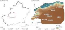
Fig. 1
Schematic diagram of the study area"

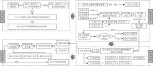
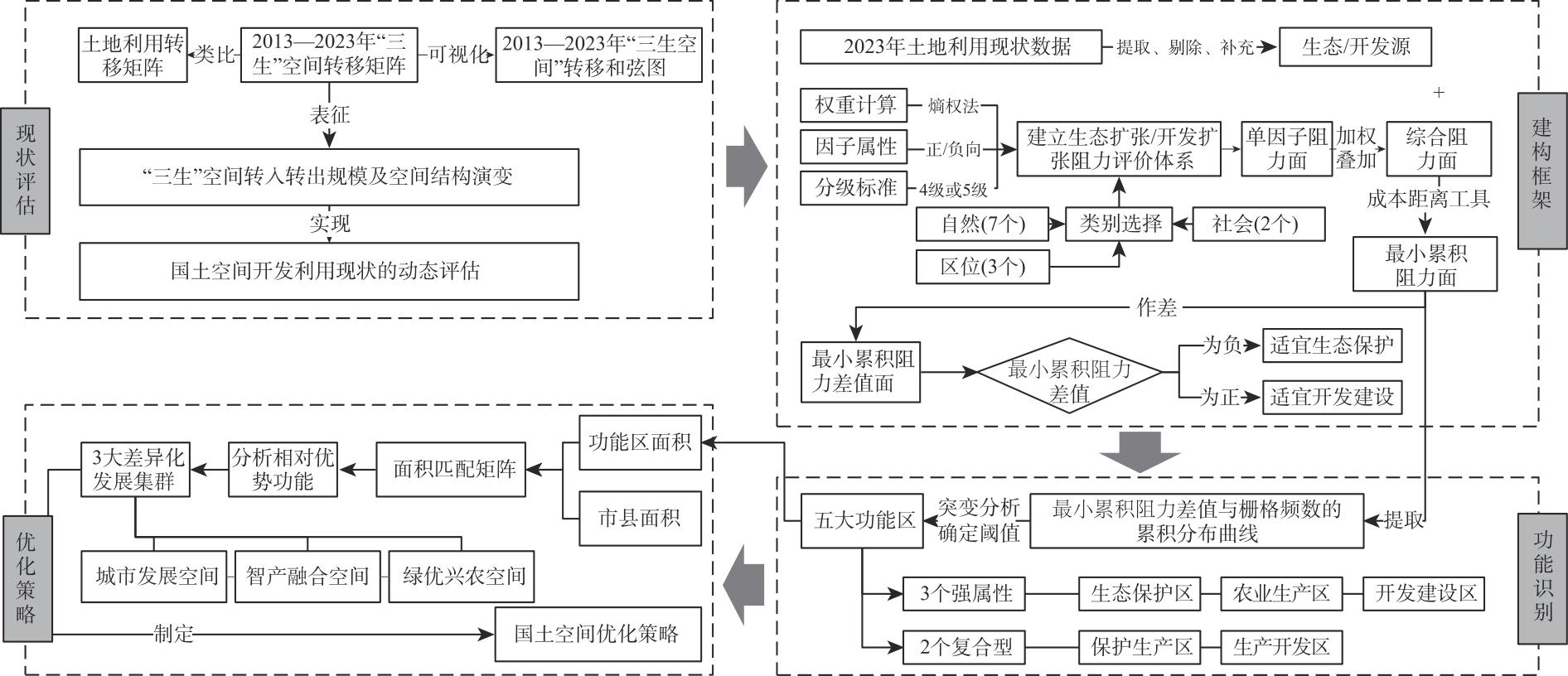
Fig. 2
Research framework for territorial space development and functional zoning"
Tab. 1
Land space development suitability evaluation indices and evaluation factor weight"
| 一级指标层 | 二级指标层 | 生态源扩张 | 开发源扩张 | |||
|---|---|---|---|---|---|---|
| 属性 | 权重 | 属性 | 权重 | |||
| 自然 | 高程/m | 正 | 0.2367 | 正 | 0.1094 | |
| 地形起伏/(°) | 正 | 0.2400 | 正 | 0.1109 | ||
| 年均气温/℃ | 负 | 0.2319 | 负 | 0.1072 | ||
| 年均降水/mm | 负 | 0.0084 | 负 | 0.0039 | ||
| 土壤质地 | 负 | 0.0220 | 正 | 0.0090 | ||
| 土地利用类型 | 正 | 0.0533 | 负 | 0.1243 | ||
| 归一化植被指数 | 负 | 0.0149 | 正 | 0.0094 | ||
| 社会 | 人口密度/人·km-2 | 正 | 0.0001 | 负 | 0.3754 | |
| 地区生产总值/104元·km-2 | 正 | 0.0014 | 负 | 0.1023 | ||
| 区位 | 距国道的距离/km | 负 | 0.0844 | 正 | 0.0065 | |
| 距省道的距离/km | 负 | 0.0935 | 正 | 0.0070 | ||
| 距水系的距离/km | 正 | 0.0134 | 负 | 0.0347 | ||
Tab. 2
Classification of expansion resistance factors of ecological source and development source"
| 阻力因子 | 生态源/开发源扩张阻力值(阻值越大,阻力越大) | ||||
|---|---|---|---|---|---|
| 1/1 | 2/2 | 3/3 | 4/4 | 5/5 | |
| 高程/m | 919~1500 | 1500~2000 | 2000~3000 | 3000~4000 | >4000 |
| 地形起伏/(°) | 0~5 | 5~10 | 10~50 | 50~100 | >100 |
| 年均气温/℃ | >10 | 5~10 | 0~5 | -5~0 | -23~-5 |
| 年均降水/mm | >40 | 30~40 | 20~30 | 10~20 | 0~10 |
| 阻力因子 | 生态源/开发源扩张阻力值(阻值越大,阻力越大) | ||||
| 1/5 | 2/4 | 3/3 | 4/2 | 5/1 | |
| 土壤质地 | 黏土 | 壤土 | 砂土 | 砾质土 | - |
| 土地利用类型 | 水域、林地 | 草地 | 耕地 | 未利用土地 | 城乡、工矿、居民用地 |
| 归一化植被指数 | >0.75 | 0.45~0.75 | 0.15~0.45 | 0.00~0.15 | <0.00 |
| 人口密度/人·km-2 | 0~10 | 10~25 | 25~50 | 50~100 | >100 |
| 地区生产总值/104元·km-2 | 0~50 | 50~100 | 100~250 | 250~500 | >500 |
| 距国道的距离/km | >1.2 | 0.8~1.2 | 0.4~0.8 | 0.2~0.4 | 0.0~0.2 |
| 距省道的距离/km | >1.2 | 0.8~1.2 | 0.4~0.8 | 0.2~0.4 | 0.0~0.2 |
| 距水系的距离/km | 0.0~0.2 | 0.2~0.4 | 0.4~0.6 | 0.6~0.8 | >0.8 |
Tab. 3
Transition matrix of “production-living-ecological” spaces from 2013 to 2023 /km2"
| “三生”空间类型 | 2023年 | ||||
|---|---|---|---|---|---|
| 生产空间 | 生活空间 | 生态空间 | 总计 | ||
| 2013年 | 生产空间 | 12146.90 | 413.42 | 2161.65 | 14721.97 |
| 生活空间 | 272.35 | 248.21 | 35.39 | 555.95 | |
| 生态空间 | 3091.52 | 83.60 | 113019.00 | 116194.12 | |
| 总计 | 15510.77 | 745.23 | 115216.04 | 131472.04 | |
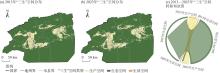
Fig. 3
Pattern of “production-living-ecological” spaces in Aksu Prefecture from 2013 to 2023"
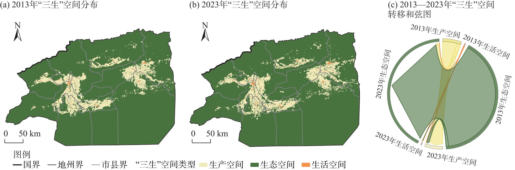
Fig. 4
Distributions of resistance sources in Aksu Prefecture"
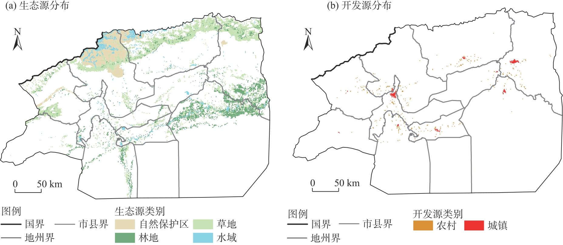
Fig. 5
Spatial distributions of single factor ecological source expansion resistance"
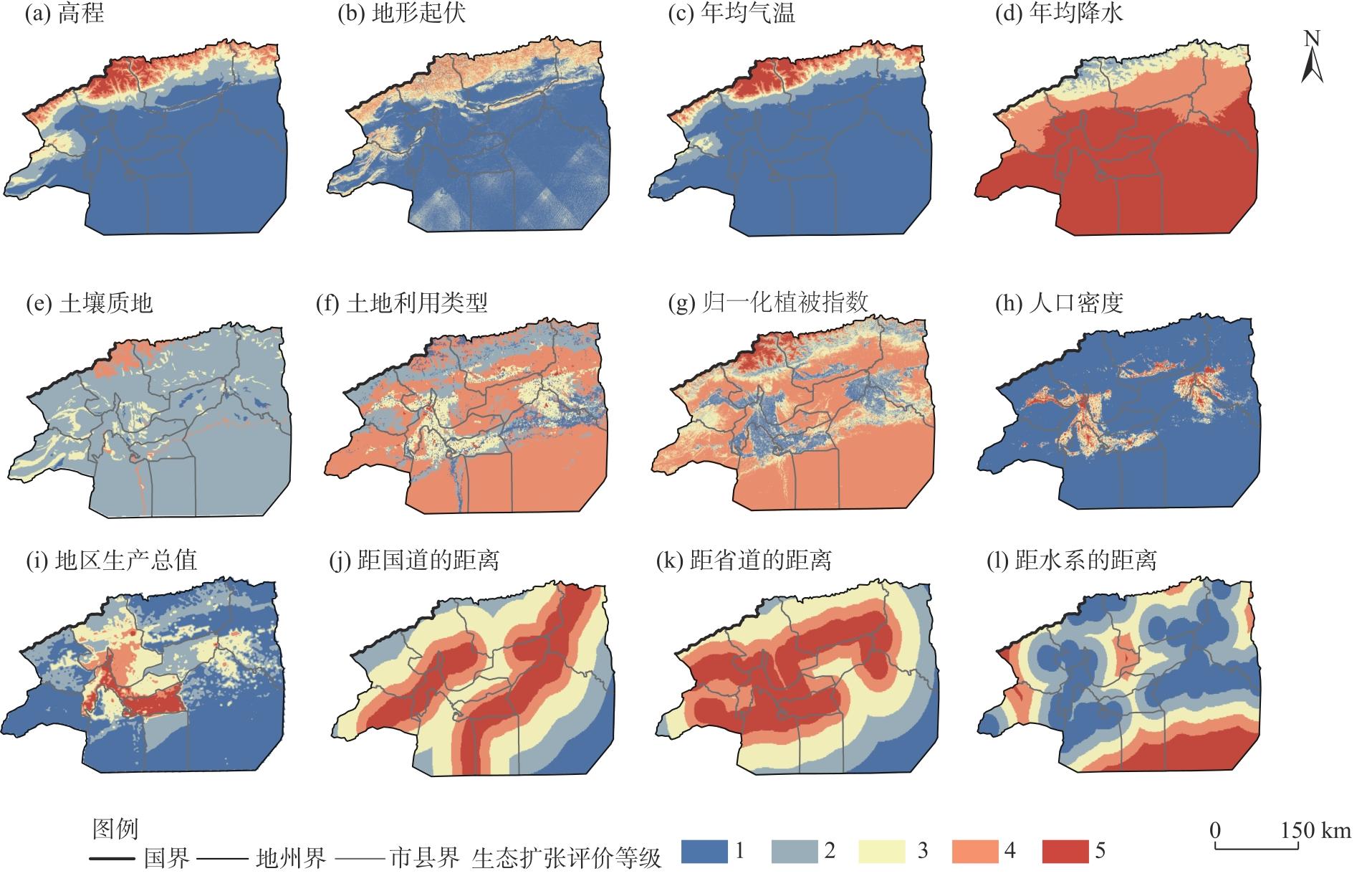
Fig. 6
Spatial distributions of single factor development source expansion resistance"


Fig. 7
Spatial distributions of source expansion comprehensive resistance"
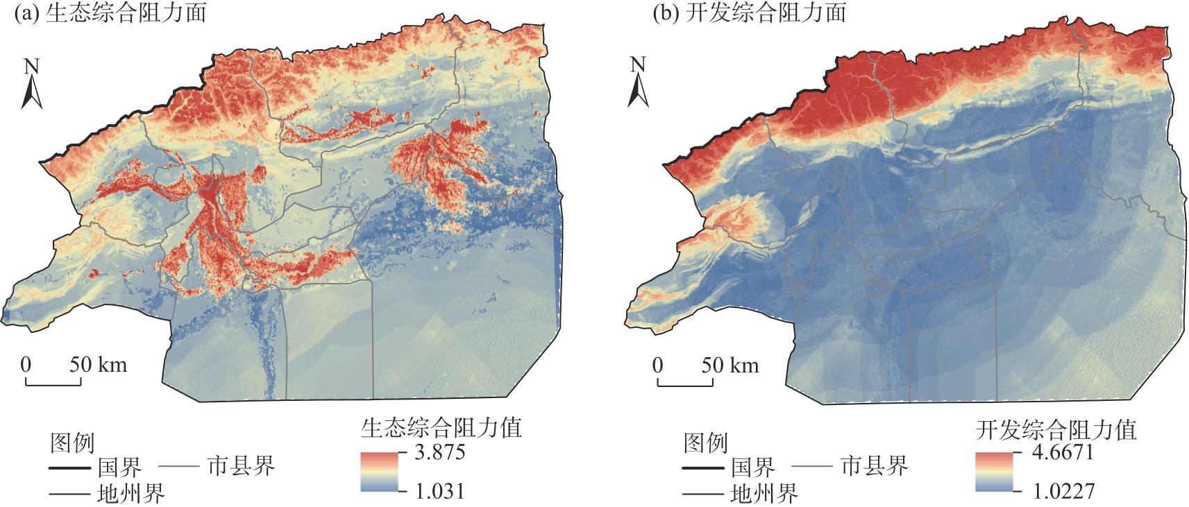
Fig. 8
Minimum cumulative analysis results"
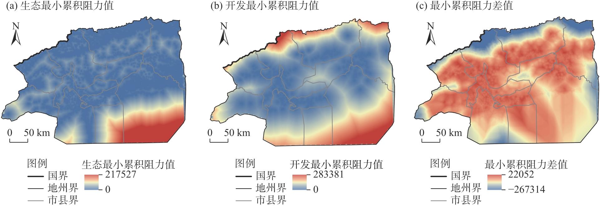
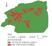
Fig. 9
Suitability evaluation results"
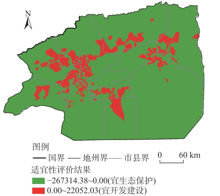
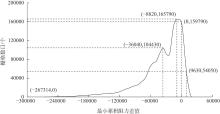
Fig. 10
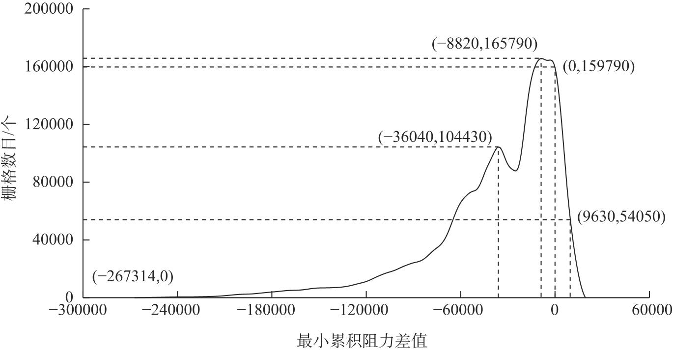
Relationship curve between the minimum cumulative resistance difference and the number of grids"
Tab. 4
Corresponding relationship of suitability-functional area-minimum cumulative resistance difference"
| 生态-开发适宜性 | 功能区 | 最小累积差值区间 |
|---|---|---|
| 生态保护适宜区 | 生态保护区 | -267314~-36040 |
| 保护生产区 | -36040~-8820 | |
| 农业生产区 | -8820~0 | |
| 开发建设适宜区 | 生产开发区 | 0~9630 |
| 开发建设区 | 9630~22052 |
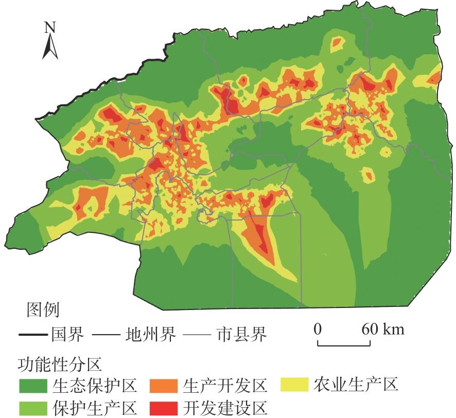
Fig. 11
Schematic diagram of land space development function zoning in Aksu Prefecture"
Tab. 5
Area statistics of territorial space functional zones in Aksu Prefecture /km2"
| 市县 | 生态保护区 | 保护生产区 | 农业生产区 | 生产开发区 | 开发建设区 | 总计 |
|---|---|---|---|---|---|---|
| 阿克苏市 | 3454.79 | 5360.08 | 2637.26 | 2472.47 | 468.83 | 14393.43 |
| 阿拉尔市 | 0.00 | 1071.17 | 1551.45 | 1125.08 | 176.27 | 3923.97 |
| 阿瓦提县 | 7386.76 | 2824.25 | 2019.36 | 744.98 | 10.91 | 12986.26 |
| 拜城县 | 7376.30 | 4107.91 | 2136.83 | 1775.26 | 445.76 | 15842.06 |
| 柯坪县 | 2432.51 | 3572.82 | 2007.89 | 825.61 | 22.68 | 8861.51 |
| 库车市 | 7547.11 | 3326.34 | 1897.67 | 1501.28 | 225.62 | 14498.02 |
| 沙雅县 | 16312.44 | 13417.19 | 1330.20 | 684.42 | 84.55 | 31828.80 |
| 温宿县 | 5845.00 | 3485.93 | 1969.20 | 2497.55 | 483.92 | 14281.60 |
| 乌什县 | 3136.62 | 2232.12 | 1880.63 | 1486.22 | 269.02 | 9004.61 |
| 新和县 | 2087.26 | 1915.60 | 1059.27 | 673.70 | 83.86 | 5819.69 |
| 全区合计 | 55578.79 | 41313.41 | 18489.76 | 13786.57 | 2271.42 | 131439.95 |
| [1] |
耿雅妮, 吴韬, 姜培钊, 等. 陕西省新型城镇化与生态环境耦合关系及情景预测[J]. 生态环境学报, 2024, 33(12): 1874-1881.
doi: 10.16258/j.cnki.1674-5906.2024.12.005 |
| [Geng Yanni, Wu Tao, Jiang Peizhao, et al. Coupling relationship between new urbanization and ecological environment in Shaanxi Province and scenario prediction[J]. Ecology and Environmental Sciences, 2024, 33(12): 1874-1881.] | |
| [2] | 马炎生, 吴大放, 罗改改. 长株潭“三生”空间适宜性耦合协调度分析[J]. 水土保持研究, 2024, 31(5): 389-398. |
| [Ma Yansheng, Wu Dafang, Luo Gaigai. Analysis on the suitability coupling coordination degree of production-living-ecology space in Changsha-Zhuzhou-Xiangtan[J]. Research of Soil and Water Conservation, 2024, 31(5): 389-398.] | |
| [3] | 张中华, 王晨鹏, 王玉蒙. 面向镇域国土空间规划的“三生空间”效能评价[J]. 西北大学学报(自然科学版), 2025, 55(4): 740-758. |
| [Zhang Zhonghua, Wang Chenpeng, Wang Yumeng. space for township-level territorial spatial planning: A case study of Taiyao Town, Tongguan County, Shaanxi Province[J]. Journal of Northwest University (Natural Science Edition), 2025, 55(4): 740-758.] | |
| [4] | 岳文泽, 韦静娴, 陈阳. 国土空间开发适宜性评价的反思[J]. 中国土地科学, 2021, 35(10): 1-10. |
| [Yue Wenze, Wei Jingxian, Chen Yang. Rethinking suitability evaluation of territorial space development[J]. China Land Science, 2021, 35(10): 1-10.] | |
| [5] |
喻忠磊, 张文新, 梁进社, 等. 国土空间开发建设适宜性评价研究进展[J]. 地理科学进展, 2015, 34(9): 1107-1122.
doi: 10.18306/dlkxjz.2015.09.004 |
|
[Yu Zhongwei, Zhang Wenxin, Liang Jinshe, et al. Progress in evaluating suitability of spatial development and construction land[J]. Progress in Geography, 2015, 34(9): 1107-1122.]
doi: 10.18306/dlkxjz.2015.09.004 |
|
| [6] |
吴大放, 胡悦, 刘艳艳, 等. 城市开发强度与资源环境承载力协调分析——以珠三角为例[J]. 自然资源学报, 2020, 35(1): 82-94.
doi: 10.31497/zrzyxb.20200108 |
|
[Wu Dafang, Hu Yue, Liu Yanyan, et al. Empirical study on the coupling coordination between development intensity and resources-and-environment carrying capacity of core cities in Pearl River Delta[J]. Journal of Natural Resources, 2020, 35(1): 82-94.]
doi: 10.31497/zrzyxb.20200108 |
|
| [7] | 何悦铭, 唐相龙. 河西走廊绿洲型县域国土空间开发适宜性评价——以张掖市高台县为例[J]. 城市建筑, 2024, 21(4): 116-119, 129. |
| [He Yueming, Tang Xianglong. Evaluation on the suitability of land space development in oasis-type counties in Hexi Corridor: A case of Gaotai County in Zhangye City[J]. Urbanism and Architecture, 2024, 21(4): 116-119, 129.] | |
| [8] | 石龙宇, 冯运双, 高莉洁. 长三角县域国土空间开发适宜性评价方法研究——以长兴县为例[J]. 生态学报, 2020, 40(18): 6495-6504. |
| [Shi Longyu, Feng Yunshuang, Gao Lijie. The method of territorial spatial development suitability evaluation in the Yangtze River Delta: A case study of Changxing County[J]. Acta Ecologica Sinica, 2020, 40(18): 6495-6504.] | |
| [9] | 冯晓菁, 罗志军, 许巾, 等. 基于“三生”空间的城乡建设用地开发适宜性及空间格局匹配评价——以江西省乐平市为例[J]. 西南农业学报, 2021, 34(9): 2014-2024. |
| [Feng Xiaojing, Luo Zhijun, Xu Jin, et al. Suitability evaluation of urban-rural construction land development and evaluation of spatial pattern matching based on ‘production-living-ecological’ space: Case study of Leping City in Jiangxi Province[J]. Southwest China Journal of Agricultural Sciences, 2021, 34(9): 2014-2024.] | |
| [10] |
荣丽华, 李伊彤. 国土空间规划背景下畜牧业生产适宜性评价与分区——以锡林郭勒盟镶黄旗为例[J]. 干旱区地理, 2023, 46(7): 1166-1175.
doi: 10.12118/j.issn.1000-6060.2022.549 |
|
[Rong Lihua, Li Yitong. Suitability evaluation and zoning of livestock production under the background of national land space planning: A case of Xianghuang Banner of Xilin Gol League[J]. Arid Land Geography, 2023, 46(7): 1166-1175.]
doi: 10.12118/j.issn.1000-6060.2022.549 |
|
| [11] | 张雅杰, 欧嘉婵. 基于TOPSIS模型的国土空间开发适宜性评价研究——以宜昌市为例[J]. 特区经济, 2024(2): 37-41. |
| [Zhang Yajie, Ou Jiachan. Evaluation of territorial spatial development suitability based on TOPSIS model: A case study of Yichang City[J]. Special Zone Economy, 2024(2): 37-41.] | |
| [12] |
杨帆, 席广亮, 甄峰, 等. “形流融合”视角的国土空间开发适宜性评价——以南京都市圈为例[J]. 资源科学, 2023, 45(12): 2372-2384.
doi: 10.18402/resci.2023.12.06 |
|
[Yang Fan, Xi Guangliang, Zhen Feng, et al. Suitability evaluation of territorial space development from the perspective of “form-flow integration”: A case study of the Nanjing metropolitan area[J]. Resources Science, 2023, 45(12): 2372-2384.]
doi: 10.18402/resci.2023.12.06 |
|
| [13] | Xia C H, Ma D H, Wang W, et al. Research on identification and zoning control of territorial spatial risk pattern based on deep learning: A case study of Shenzhen, China[J]. Journal of Cleaner Production, 2024, 481: 144132, doi: 10.1016/j.jclepro.2024.144132. |
| [14] |
杨子韬, 田莉. 基于PLUS模拟未来土地利用变化的可持续发展评估——以江西省为例[J]. 地理科学, 2024, 44(10): 1826-1836.
doi: 10.13249/j.cnki.sgs.20230581 |
|
[Yang Zitao, Tian Li. Sustainability assessment based on PLUS simulation of future land use change: A case study of Jiangxi Province[J]. Scientia Geographica Sinica, 2024, 44(10): 1826-1836.]
doi: 10.13249/j.cnki.sgs.20230581 |
|
| [15] | 朱从谋, 苑韶峰, 杨丽霞. 主体功能区视角下国土空间格局演变及生态环境效应——以浙江省为例[J]. 生态学报, 2023, 43(11): 4488-4501. |
| [Zhu Congmou, Wan Shaofeng, Yang Lixia. Evolution of territorial spatial pattern and associated eco-environmental effects from the perspective of major functional zones: A case study of Zhejiang Province[J]. Acta Ecologica Sinica, 2023, 43(11): 4488-4501.] | |
| [16] |
金贵, 郭柏枢, 成金华, 等. 基于资源效率的国土空间布局及支撑体系框架[J]. 地理学报, 2022, 77(3): 534-546.
doi: 10.11821/dlxb202203003 |
|
[Jin Gui, Guo Baishu, Cheng Jinhua, et al. Layout optimizationand support system of territorial space: An analysis framework based on resource efficiency[J]. Acta Geographica Sinica, 2022, 77(3): 534-546.]
doi: 10.11821/dlxb202203003 |
|
| [17] | Yang J X, Zhao J, Zhu G F, et al. Effects of ecological water conveyance on soil salinization in the Shiyang River Basin’s Terminal Lake-Qingtu Lake-Area[J]. Sustainability, 2022, 14(16): 10311, doi: 10.3390/su141610311. |
| [18] | 新疆生产建设兵团第一师统计局. 2023年1—12月师市经济运行综合分析[R/OL]. [2025-09-28]. http://www.ale.gov.cn/publicity/tjxx/43896. |
| [Bureau of Statistics of the First Division of Xinjiang Production and Construction Corps. Comprehensive analysis of the the division-city economic operation from January to December 2023[R/OL]. [2025-09-28]. http://www.ale.gov.cn/publicity/tjxx/43896.] | |
| [19] | 阿克苏地区统计局. 阿克苏地区2023年国民经济和社会发展统计公报[R/OL]. [2025-09-28]. https://www.aks.gov.cn/sjkf/tjnb/20240412/i1299741.html. |
| [Bureau of Statistics of Aksu Prefecture. Statistical bulletin on the national economic and social development of Aksu Prefecture in 2023[R/OL]. [2025-09-28]. https://www.aks.gov.cn/sjkf/tjnb/20240412/i1299741.html.] | |
| [20] |
田柳兰, 王珊珊, 毋兆鹏. 基于多时相遥感数据的乌鲁木齐市生态安全格局构建[J]. 干旱区地理, 2023, 46(7): 1155-1165.
doi: 10.12118/j.issn.1000-6060.2022.473 |
| [Tian Liulan, Wang Shanshan, Wu Zhaopeng. Construction of ecological security pattern in Urumqi based on multi-temporal remote sensing data[J]. Arid Land Geography, 2023, 46(7): 1155-1165.] | |
| [21] |
屠正伟, 张沛, 张中华. 银川都市圈乡村“三生空间”冲突格局演变特征及影响因素[J]. 干旱区地理, 2026, 49(3): 594-606.
doi: 10.12118/j.issn.1000-6060.2025.199 |
|
[Tu Zhengwei, Zhang Pei, Zhang Zhonghua. Evolutionary characteristics and influencing factors of spatial conflicts in rural “production-living-ecological spaces” of the Yinchuan metropolitan coordinating region[J]. Arid Land Geography, 2026, 49(3): 594-606.]
doi: 10.12118/j.issn.1000-6060.2025.199 |
|
| [22] | 张考, 黄春华, 王志远, 等. 基于DTTD-MCR-PLUS模型的三生空间格局优化——以长沙市为例[J]. 生态学报, 2022, 42(24): 9957-9970. |
| [Zhang Kao, Huang Chunhua, Wang Zhiyuan, et al. Optimization of“production-living-ecological”spaces based on DTTD-MCRPLUS model: Taking Changsha City as an example[J]. Acta Ecologica Sinica, 2022, 42(24): 9957-9970.] | |
| [23] | 孙桐, 雷冬梅, 刘林, 等. 基于最小累计阻力模型和情景模拟法的滇池流域最小生态用地量化对比研究[J]. 生态学报, 2024, 44(20): 9135-9145. |
| [Sun Tong, Lei Dongmei, Liu Lin, et al. Comparative study on the minimum ecological land quantification in Dianchi Lake Basin based on MCR model and scenario simulation method[J]. Acta Ecologica Sinica, 2024, 44(20): 9135-9145.] | |
| [24] |
Knaapen J P, Scheffer M, Harms B. Estimating habitat isolation in landscape planning[J]. Landscape and Urban Planning, 1992, 23(1): 1-16.
doi: 10.1016/0169-2046(92)90060-D |
| [25] | 俞孔坚. 生物保护的景观生态安全格局[J]. 生态学报, 1999, 19(1): 10-17. |
| [Yu Kongjian. Landscape ecological security patterns in biological conservation[J]. Acta Ecologica Sinica, 1999, 19(1): 10-17.] | |
| [26] | 汉瑞英, 赵志平, 肖能文, 等. 基于最小累积阻力差值模型的北京市生态安全格局构建[J]. 水土保持通报, 2022, 42(3): 95-102. |
| [Han Ruiying, Zhao Zhiping, Xiao Nengwen, et al. Construction of ecological security pattern in Beijing City based on minimum resistance model[J]. Bulletin of Soil and Water Conservation, 2022, 42(3): 95-102.] | |
| [27] | 魏伟, 王雅宁, 尹力, 等. 2000—2020年内蒙古高原国土空间演化生态效应及其影响因素[J]. 生态学报, 2025, 45(6): 2968-2984. |
| [Wei Wei, Wang Yaning, Yin Li, et al. The ecological effects of territorial spatial evolution and its influencing factors in the Inner Mongolia Plateau from 2000 to 2020[J]. Acta Ecologica Sinica, 2025, 45(6): 2968-2984.] | |
| [28] | 吴可欣, 税伟, 张永永, 等. 基于生态优先与未来情景模拟的城市群国土空间开发适宜性评价——以闽三角城市群为例[J]. 宁夏大学学报(自然科学版), 2023, 44(4): 377-383. |
| [Wu Kexin, Shui Wei, Zhang Yongyong, et al. Territorial development suitability evaluation of urban agglomeration based on ecological priorities and future scenario simulation[J]. Journal of Ningxia University (Natural Science Edition), 2023, 44(4): 377-383.] | |
| [29] | 林伊琳, 赵俊三, 陈国平, 等. 基于MCR-FLUS-Markov模型的区域国土空间格局优化[J]. 农业机械学报, 2021, 52(4): 159-170, 207. |
| [Lin Yilin, Zhao Junsan, Chen Guoping, et al. Optimization of regional territory space pattern based on MCR-FLUS-Markov model[J]. Transactions of the Chinese Society for Agricultural Machinery, 2021, 52(4): 159-170.] | |
| [30] | 赵润哲, 苏维, 李彦克. 基于最小累计阻力模型的卢氏县土地生态适宜性评价[J]. 林业调查规划, 2024, 49(2): 90-96. |
| [Zhao Runzhe, Su Wei, Li Yanke. Evaluation of land ecological suitability in Lushi County based on minimum cumulative resistance model[J]. Forest Inventory and Planning, 2024, 49(2): 90-96.] | |
| [31] | 翟端强, 卓健, 徐弈. 市县级国土空间生态风险评估方法优化研究[J]. 规划师, 2023, 39(2): 53-60. |
| [Zhai Duanqiang, Zhuo Jian, Xu Yi. Optimization of ecological risk assessment in city and county level territorial space planning[J]. Planners, 2023, 39(2): 53-60.] | |
| [32] |
吴桐, 岳文泽, 夏皓轩, 等. 国土空间规划视域下主体功能区战略优化[J]. 经济地理, 2022, 42(2): 11-17, 73.
doi: 10.15957/j.cnki.jjdl.2022.02.002 |
|
[Wu Tong, Yue Wenze, Xia Haoxuan, et al. Optimization of major function zoning strategy from the perspective of territorial spatial planning[J]. Economic Geography, 2022, 42(2): 11-17, 73.]
doi: 10.15957/j.cnki.jjdl.2022.02.002 |
|
| [33] | 崔健, 代雅建, 孙秀波, 等. 基于生态适宜性评价的辽源市西安煤矿区国土空间优化[J/OL]. 地质通报. [2025-09-23]. https://link.cnki.net/urlid/11.4648.P.20250116.1351.002. |
| [Cui Jian, Dai Yajian, Sun Xiubo, et al. Territorial space optimization of Xi’an coal mining area in Liaoyuan City based on ecological suitability assessment[J/OL]. Geological Bulletin of China. [2025-09-23]. https://link.cnki.net/urlid/11.4648.P.20250116.1351.002.] |
|
||