Arid Land Geography ›› 2022, Vol. 45 ›› Issue (5): 1490-1499.doi: 10.12118/j.issn.1000-6060.2022.041
• Earth Surface Process • Previous Articles Next Articles
QIN Tong1( ),LI Gongquan1(),FAN Jiachen2
Received:2022-01-24
Revised:2022-04-22
Online:2022-09-25
Published:2022-10-20
Contact:
Gongquan LI
E-mail:1344023414@qq.com;Gongquan_Li@126.com
QIN Tong,LI Gongquan,FAN Jiachen. Spatial-temporal evolution of land degradation in the Yellow River Source Park in recent 20 years[J].Arid Land Geography, 2022, 45(5): 1490-1499.
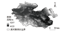
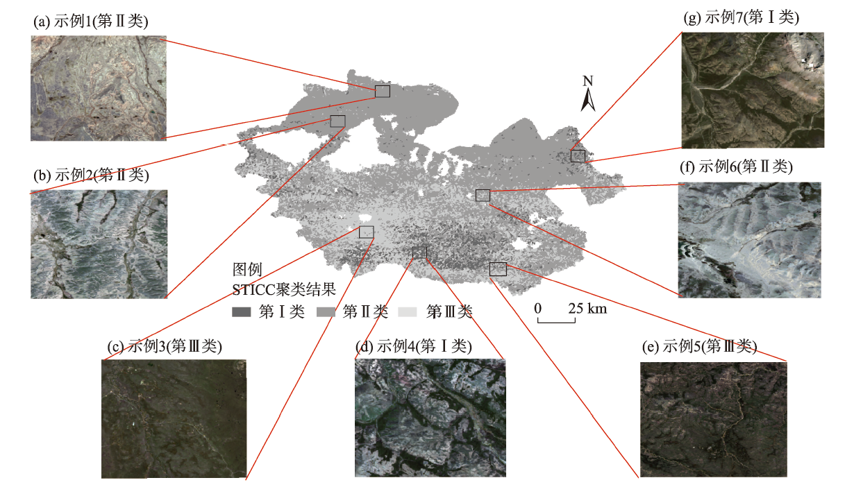
Fig. 1
Topographic map of Sanjiangyuan Yellow River Source Park"
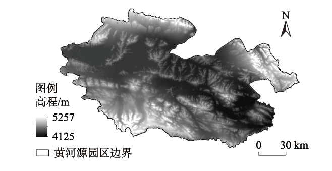
Fig. 2
Extraction of optimal catchment threshold"

Tab. 1
Weight determination of land degradation indices"
| 指数 | 2000年 | 2005年 | 2010年 | 2015年 | 2020年 |
|---|---|---|---|---|---|
| 土壤侵蚀模数 (正向指标) | 0.768 | 0.504 | 0.606 | 0.887 | 0.870 |
| 沙化特征指数 (正向指标) | 0.162 | 0.454 | 0.329 | 0.025 | 0.044 |
| 土壤湿度指数 (逆向指标) | 0.070 | 0.042 | 0.065 | 0.089 | 0.086 |
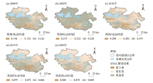
Fig. 3
Spatial distribution of land degradation"


Fig. 4
Comparison of spatial distribution results of land degradation"
Tab. 2
Spatial and temporal evolution statistics of land degradation degree"
 |
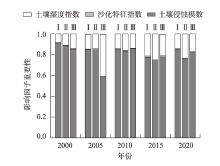
Fig. 5
Importance of land degradation impact factors"
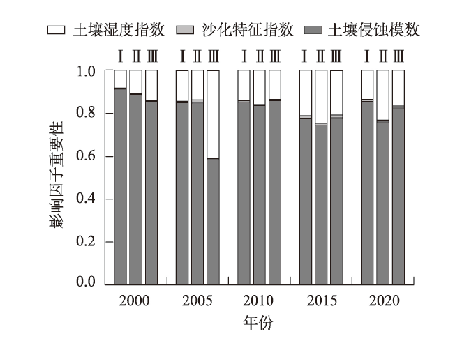
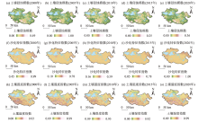
Fig. 6
Distributions of land degradation impact factors"

| [1] | Stocking M A. Land Degradation[DB/OL]. Science Direct. [2002-11-02]. https://www.sciencedirect.com/science/article/pii/B008043076704184X.html. |
| [2] | 黄炎和. 土地生态学[M]. 北京: 中国农业出版社, 2013: 131-134. |
| [Huang Yanhe. Land ecology[M]. Beijing: China Agricultural Press, 2013: 131-134. ] | |
| [3] |
Yue Y J, Li M, Zhu A X, et al. Land degradation monitoring in the Ordos Plateau of China using an expert knowledge and BP-ANN-based approach[J]. Sustainability, 2016, 8(11): 1174, doi: 10.3390/su8111174.
doi: 10.3390/su8111174 |
| [4] |
Han W Y, Liu G H, Su X K, et al. Assessment of potential land degradation and recommendations for management in the south subtropical region, southwest China[J]. Land Degradation & Development, 2019, 30(8): 979-990.
doi: 10.1002/ldr.3285 |
| [5] | Yang C, Li Q Q, Chen J Y, et al. Spatiotemporal characteristics of land degradation in the Fuxian Lake Basin, China: Past and future[J]. Land Degradation & Development, 2020, 32(16): 2446-2460. |
| [6] | 杜子涛, 杨小明, 颜树强, 等. 奈曼旗土地退化遥感监测研究[J]. 农业工程学报, 2012, 28(3): 154-161. |
| [Du Zitao, Yang Xiaoming, Yan Shuqiang, et al. Study on land degradation monitoring in Naiman County using remote sensing[J]. Transactions of the Chinese Society of Agricultural Engineering, 2012, 28(3): 154-161. ] | |
| [7] | Ye W, Wang Q B, Guo B, et al. A novel large-scale land degradation remote sensing index and its application in Three River Source Region[J/OL]. Earth Science Informatics. [2022-01-27]. http://link.springer.com/article/10.1007/s12145-021-00724-0.html. |
| [8] | 许明杰, 牛瑞卿, 杨柯, 等. 一种土地生态敏感性评估的加权聚类方法[J]. 测绘科学, 2021, 46(10): 118-129, 144. |
| [Xu Mingjie, Niu Ruiqing, Yang Ke, et al. A weighted clustering model for land eco-environmental sensitivity evaluation[J]. Science of Surveying and Mapping, 2021, 46(10): 118-129, 144. ] | |
| [9] |
Grinand C, Vieilledent G, Razafimbelo T. Landscape-scale spatial modelling of deforestation, land degradation, and regeneration using machine learning tools[J]. Land Degradation & Development, 2020, 31(13): 1699-1712.
doi: 10.1002/ldr.3526 |
| [10] | 赵新全, 周华坤. 三江源区生态环境退化、恢复治理及其可持续发展[J]. 中国科学院院刊, 2005, 20(6): 37-42. |
| [Zhao Xinquan, Zhou Huakun. Eco-environmental degradation, vegetation regeneration and sustainable development in the headwaters of Three Rivers on Tibetan Plateau[J]. Bulletin of Chinese Academy of Sciences, 2005, 20(6): 37-42. ] | |
| [11] | 董锁成, 周长进, 王海英. “三江源”地区主要生态环境问题与对策[J]. 自然资源学报, 2002, 17(6): 713-720. |
| [Dong Suocheng, Zhou Changjin, Wang Haiying. Ecological crisis and countermeasures of the Three Rivers’ headstream regions[J]. Journal of Natural Resources, 2002, 17(6): 713-720. ] | |
| [12] | Kang Y H, Wu K, Gao S, et al. STICC: A multivariate spatial clustering method for repeated geographic pattern discovery with consideration of spatial contiguity[J/OL]. International Journal of Geographical Information Science.[2002-03-30]. https://doi.org/10.1080/13658816.2022.2053980.html. |
| [13] | Chen T Q, Guestrin C. XGBoost: A scalable tree boosting system[DB/OL]. ACM Digital Library. [2016-08-13]. https://dl.acm.org/doi/10.1145/2939672.2939785.html. |
| [14] | 王旭峰. 三江源国家公园界线矢量数据集[DB/OL]. 国家青藏高原科学数据中心. [2021-04-22]. http://data.tpdc.ac.cn/zh-hans/data/a2cc2fb2-ba29-4059-af5f-6d58acf654c8.html. |
| [Wang Xufeng. Boundary vector data set of Sanjiangyuan National Park[DB/OL]. National Tibetan Plateau Data Center. [2021-04-22]. http://data.tpdc.ac.cn/zh-hans/data/a2cc2fb2-ba29-4059-af5f-6d58acf654c8.html. ] | |
| [15] | 刘婷婷, 朱秀芳, 郭锐, 等. ERA5再分析降水数据在中国的适用性分析[J]. 干旱区地理, 2022, 45(1): 66-79. |
| [Liu Tingting, Zhu Xiufang, Guo Rui, et al. Applicability of ERA5 reanalysis of precipitation data in China[J]. Arid Land Geography, 2022, 45(1): 66-79. ] | |
| [16] | 戴永久, 上官微. 中国土壤有机质数据集[DB/OL]. 国家青藏高原科学数据中心. [2021-04-19]. http://data.tpdc.ac.cn/zh-hans/data/8ba0a731-5b0b-4e2f-8b95-8b29cc3c0f3a.html. |
| [Dai Yongjiu, Shangguan Wei. Dataset of soil properties for land surface modeling over China[DB/OL]. National Tibetan Plateau Data Center. [2021-04-19]. http://data.tpdc.ac.cn/zh-hans/data/8ba0a731-5b0b-4e2f-8b95-8b29cc3c0f3a.html. ] | |
| [17] | 郑子豪, 吴志峰, 陈颖彪, 等. 基于Google Earth Engine的长三角城市群生态环境变化与城市化特征分析[J]. 生态学报, 2021, 41(2): 717-729. |
| [Zheng Zihao, Wu Zhifeng, Chen Yingbiao, et al. Analyzing the ecological environment and urbanization characteristics of the Yangtze River Delta urban agglomeration based on Google Earth Engine[J]. Acta Ecologica Sinica, 2021, 41(2): 717-729. ] | |
| [18] | Panagosa P, Borrellia P, Poesen J, et al. The new assessment of soil loss by water erosion in Europe[J]. Environmental Science & Policy, 2015, 54: 438-447. |
| [19] | 周来, 李艳洁, 孙玉军. 修正的通用土壤流失方程中各因子单位的确定[J]. 水土保持通报, 2018, 38(1): 169-174. |
| [Zhou Lai, Li Yanjie, Sun Yujun. Determination of each factor unit in the modified general soil loss equation[J]. Bulletin of Soil and Water Conservation, 2018, 38(1): 169-174. ] | |
| [20] | 章文波, 谢云, 刘宝元. 中国降雨侵蚀力空间变化特征[J]. 山地学报, 2003, 2003(1): 33-40. |
| [Zhang Wenbo, Xie Yun, Liu Baoyuan. Spatial variation characteristics of rainfall erosivity in China[J]. Mountain Research, 2003, 2003(1): 33-40. ] | |
| [21] | 张科利, 彭文英, 杨红丽. 中国土壤可蚀性值及其估算[J]. 土壤学报, 2007, 44(1): 7-13. |
| [Zhang Keli, Peng Wenying, Yang Hongli. Soil erodibility and its estimation for agricultural soil in China[J]. Acta Pedologica Sinica, 2007, 44(1): 7-13. ] | |
| [22] |
Liu B Y, Nearing M A, Risse L M. Slope gradient effects on soil loss for steep slopes[J]. Transaction of the ASAE, 1994, 37(6): 1835-1840.
doi: 10.13031/2013.28273 |
| [23] |
Foster G R, Wischmeier W H. Evaluating irregular slopes for soil loss prediction[J]. Environment Earth Sciences, 2014, 73(1): 2141-2151.
doi: 10.1007/s12665-014-3564-3 |
| [24] | Wischmier W H, Smith D D. Predicting grainfall erosion losses: A guide to conservation planning[M]. Washington: United States Department of Agriculture, 1978: 537. |
| [25] | 蔡崇法, 丁树文, 史志华, 等. 应用USLE模型与地理信息系统IDRISI预测小流域土壤侵蚀量的研究[J]. 水土保持学报, 2000, 14(2): 19-24. |
| [Cai Chongfa, Ding Shuwen, Shi Zhihua, et al. Study of applying USLE and geographical information system IDRISI to predict soil erosion in small watershed[J]. Journal of Soil and Water Conservation, 2000, 14(2): 19-24. ] | |
| [26] | 章影, 廖畅, 姜庆虎, 等. 丹江口库区土壤侵蚀对土地利用变化的响应[J]. 水土保持通报, 2017, 37(1): 104-111, 2. |
| [Zhang Ying, Liao Chang, Jiang Qinghu, et al. Response of soil erosion to land use change in Danjiangkou Reservoir area[J]. Bulletin of Soil and Water Conservation, 2017, 37(1): 104-111, 2. ] | |
| [27] | 赖晗, 芮小平, 梁汉东, 等. 基于均值变点分析的三峡库区河网提取研究[J]. 测绘科学, 2012, 37(5): 173-175. |
| [Lai Han, Rui Xiaoping, Liang Handong, et al. Extraction of drainage network in Three Gorge Reservoir area based on mean change point method[J]. Science of Surveying and Mapping, 2012, 37(5): 173-175. ] | |
| [28] | 山成菊, 董增川, 樊孔明, 等. 组合赋权法在河流健康评价权重计算中的应用[J]. 河海大学学报(自然科学版), 2012, 40(6): 622-628. |
| [Shan Chengju, Dong Zengchuan, Fan Kongming, et al. Application of combination weighting method to weight calculation in river health evaluation[J]. Journal of Hehai University (Natural Science Edition), 2012, 40(6): 622-628. ] | |
| [29] | 谷昊鑫, 秦伟山, 赵明明, 等. 黄河流域旅游经济与生态环境协调发展时空演变及影响因素探究[J]. 干旱区地理, 2022, 45(2): 628-638. |
| [Gu Haoxin, Qin Weishan, Zhao Mingming, et al. Spatial and temporal evolution and influencing factors of coordinated development of tourism economy and ecological environment in the Yellow River Basin[J]. Arid Land Geography, 2022, 45(2): 628-638. ] | |
| [30] | 胡光印, 董治宝, 逯军峰, 等. 黄河流域沙漠化空间格局与成因[J]. 中国沙漠, 2021, 41(4): 213-224. |
| [Hu Guangyin, Dong Zhibao, Lu Junfeng, et al. Spatial pattern of aeolian desertification and its causes in the Yellow River catchment[J]. Journal of Desert Research, 2021, 41(4): 213-224. ] | |
| [31] | 姚旭阳, 张明军, 张宇, 等. 中国西北地区气候转型的新认识[J]. 干旱区地理, 2022, 45(3): 671-683. |
| [Yao Xuyang, Zhang Mingjun, Zhang Yu, et al. New insights into climate transition in northwest China[J]. Arid Land Geography, 2022, 45(3): 671-683. ] |
| [1] | TANG Taibin, ZHOU Bao, JIN Xiaomei, WEI Sailajia, MA Tao, ZHANG Yongyan. Change of surface temperature in the source area of the Yellow River in summer [J]. Arid Land Geography, 2023, 46(8): 1250-1259. |
| [2] | CHENG Shuo, LI Yanzhong, XING Yincong, YU Zhiguo, WANG Yuangang, HUANG Manjie. Simulation performance of remote sensing precipitation products on hydrological drought characteristics in the source region of the Yellow River [J]. Arid Land Geography, 2023, 46(7): 1063-1072. |
| [3] | YANG Xuewen, WANG Ninglian, LIANG Qian, CHEN An’an. Glacier changes on the north slope of Tianshan Mountains in recent 60 years [J]. Arid Land Geography, 2023, 46(7): 1073-1083. |
| [4] | LI Shiyao, CONG Shixiang, WANG Rongrong, YU Hailong, HUANG Juying. Monitoring of maize canopy SPAD value under drought stress based on UAV multi-spectral remote sensing [J]. Arid Land Geography, 2023, 46(7): 1121-1132. |
| [5] | TIAN Liulan, WANG Shanshan, WU Zhaopeng. Construction of ecological security pattern in Urumqi based on multi-temporal remote sensing data [J]. Arid Land Geography, 2023, 46(7): 1155-1165. |
| [6] | DONG Jiefang, ZHANG Kaili, QU Xueshu, RUAN Zheng. Measurement and influencing factors of ecological well-being performance of cities in Yellow River Basin [J]. Arid Land Geography, 2023, 46(5): 834-845. |
| [7] | JIANG Leipeng,DING Jianli,BAO Qingling,GE Xiangyu,LIU Jingming,WANG Jinjie. Runoff estimation with low altitude remote sensing and satellite images [J]. Arid Land Geography, 2023, 46(3): 385-396. |
| [8] | LI Xinyu,WANG Jingpu,WANG Zhoulong. Research progress on aerodynamic roughness [J]. Arid Land Geography, 2023, 46(3): 407-417. |
| [9] | ZHANG Sarilang, Wulantuya , Buhe , Yongmei , Siqinchaoketu , ZHANG Weiqing. Bibliometric analysis of land desertification research on the Mongolian Plateau in recent 40 years [J]. Arid Land Geography, 2023, 46(12): 1984-1994. |
| [10] | JI Qin, ZHANG Cuilan, DING Yuekai, CAO Xiangqin, LIANG Wenli. Glacier monitoring in Qomolangma Nature Reserve based on multi-source remote sensing data [J]. Arid Land Geography, 2023, 46(10): 1591-1601. |
| [11] | ZHANG Juan, YAO Xiaojun, LI Jing, WANG Xiaoyan. Agricultural drought research based on multi-source remote sensing data in Gansu Province [J]. Arid Land Geography, 2023, 46(1): 11-22. |
| [12] | DING Yuekai, LIU Rui, ZHANG Cuilan, TONG Liyuan, DONG Jun. Remote sensing monitoring of glacier and glacial lake changes in Yairu Zangbo Basin, Himalayas [J]. Arid Land Geography, 2022, 45(6): 1870-1880. |
| [13] | ZHAO Shuang,DING Jianli,HAN Lijing,HUANG Shuai,GE Xiangyu. Response analysis and modeling of microwave dielectric properties of typical saline soil in Xinjiang [J]. Arid Land Geography, 2022, 45(5): 1534-1546. |
| [14] | XIE Conghui,WU Shixin,LIN Juan,ZHUANG Qingwei,ZHANG Zihui,HOU Guanyu,LUO Geping. Analysis of cultivated land salinization in Kashgar Oasis based on PSO-PNN model [J]. Arid Land Geography, 2022, 45(5): 1547-1558. |
| [15] | WANG Jinjie,DING Jianli,ZHANG Zipeng. Change of ecological environment in Turpan and Hami cities based on remote sensing ecology index [J]. Arid Land Geography, 2022, 45(5): 1591-1603. |
|
||