干旱区地理 ›› 2026, Vol. 49 ›› Issue (2): 301-315.doi: 10.12118/j.issn.1000-6060.2025.204 cstr: 32274.14.ALG2025204
裴若颖1,2( ), 曹生奎1,2,3(), 侯瑶芳1,2, 雷义珍1,2, 王江1,2, 刘振梅1,2, 丁辰深1,2
收稿日期:2025-04-14
修回日期:2025-06-16
出版日期:2026-02-25
发布日期:2026-02-27
通讯作者:
曹生奎(1979-),男,教授,主要从事生态水文与水资源学等方面的研究. E-mail: caoshengkui@163.com作者简介:裴若颖(2001-),女,硕士研究生,主要从事生态水文与水资源学等方面的研究. E-mail: peiruoying2001@163.com
基金资助:
PEI Ruoying1,2(), CAO Shengkui1,2,3(), HOU Yaofang1,2, LEI Yizhen1,2, WANG Jiang1,2, LIU Zhenmei1,2, DING Chenshen1,2
Received:2025-04-14
Revised:2025-06-16
Published:2026-02-25
Online:2026-02-27
摘要:
草地植被生物量是衡量草地生态系统生产力和碳储量的重要指标,其空间分布格局及其驱动机制对于理解区域草地生态系统结构与功能的维持及其应对气候变化具有重要科学意义。以青海湖流域为研究对象,基于2023年7—8月的实地采样数据与遥感数据,采用数理统计、相关分析和结构方程模型等多种方法研究了青海湖流域草地植被生物量(包括地上和地下生物量)的空间分布特征及其驱动路径。结果表明:(1) 不同草地植被类型生物量差异显著,草甸类高于草原类,地上生物量(AGB)以山地灌丛草甸最高(311.54 g·m-2),山地泥流草甸最低(64.67 g·m-2);地下生物量(BGB)以矮生嵩草草甸最高(3534.05 g·m-2),红景天荒漠最低(339.12 g·m-2)。(2) AGB高值主要集中于沙柳河流域中下游和环湖地区南部,BGB和总生物量(TB)高值区主要位于布哈河中游、泉吉河流域、恰当曲流域和沙柳河中游;低海拔地区具备更适宜的温度和肥沃的土壤,促进地上部分生长;高海拔地区因寒冷和土壤贫瘠,植物倾向于增强根系发育以提高资源获取能力。(3) 生态系统碳利用效率(CUE)(总效益-0.44)和土壤容重(BD)(总效益-0.59)是影响草地植被AGB和BGB的直接因子。综上,青海湖流域草地植被受植被类型和区域环境的共同影响,CUE和BD是主要因素。研究结果可为深入认识青海湖流域草地植被生物量空间规律和生态系统保护与恢复提供基础数据和科学依据。
裴若颖, 曹生奎, 侯瑶芳, 雷义珍, 王江, 刘振梅, 丁辰深. 青海湖流域草地植被生物量空间分布格局研究[J]. 干旱区地理, 2026, 49(2): 301-315.
PEI Ruoying, CAO Shengkui, HOU Yaofang, LEI Yizhen, WANG Jiang, LIU Zhenmei, DING Chenshen. Spatial distribution pattern of grassland vegetation biomass in the Qinghai Lake Basin[J]. Arid Land Geography, 2026, 49(2): 301-315.
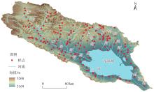
图1
青海湖流域采样点空间分布"
表1
青海湖流域草地植被地上和地下生物量及根冠比统计"
| 指标 | 最大值 | 最小值 | 平均值 | 标准差 | 中值 |
|---|---|---|---|---|---|
| 地上生物量/g·m-2 | 489.20 | 28.53 | 141.41 | 96.82 | 109.47 |
| 地下生物量/g·m-2 | 7690.49 | 212.31 | 2787.19 | 1649.18 | 2465.20 |
| 总生物量/g·m-2 | 7778.89 | 314.09 | 2928.53 | 1661.50 | 2729.98 |
| 根冠比 | 119.66 | 1.55 | 29.93 | 25.23 | 20.75 |
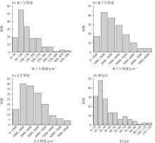
图2
青海湖流域草地植被生物量和根冠比频数分布"
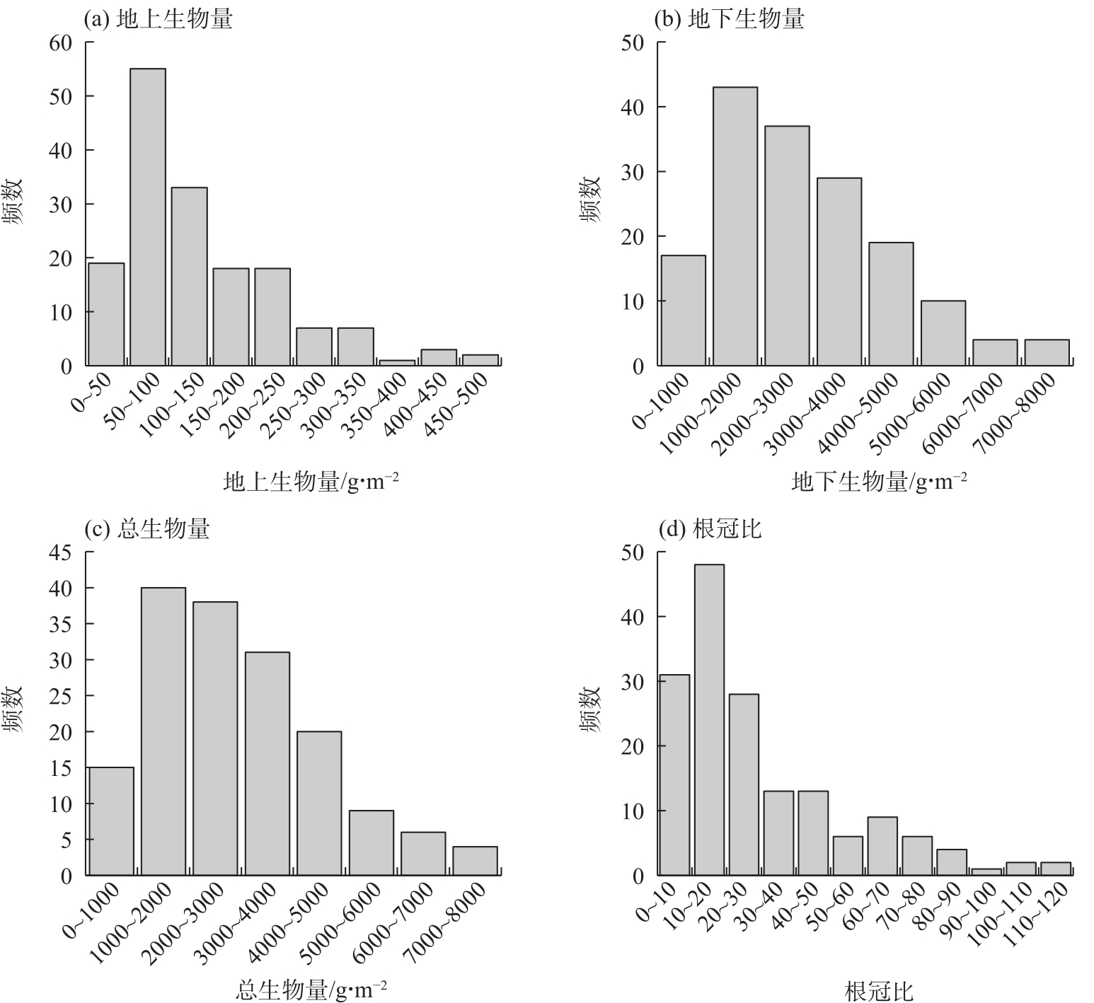
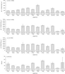
图3
青海湖流域不同草地植被类型生物量及根冠比对比"
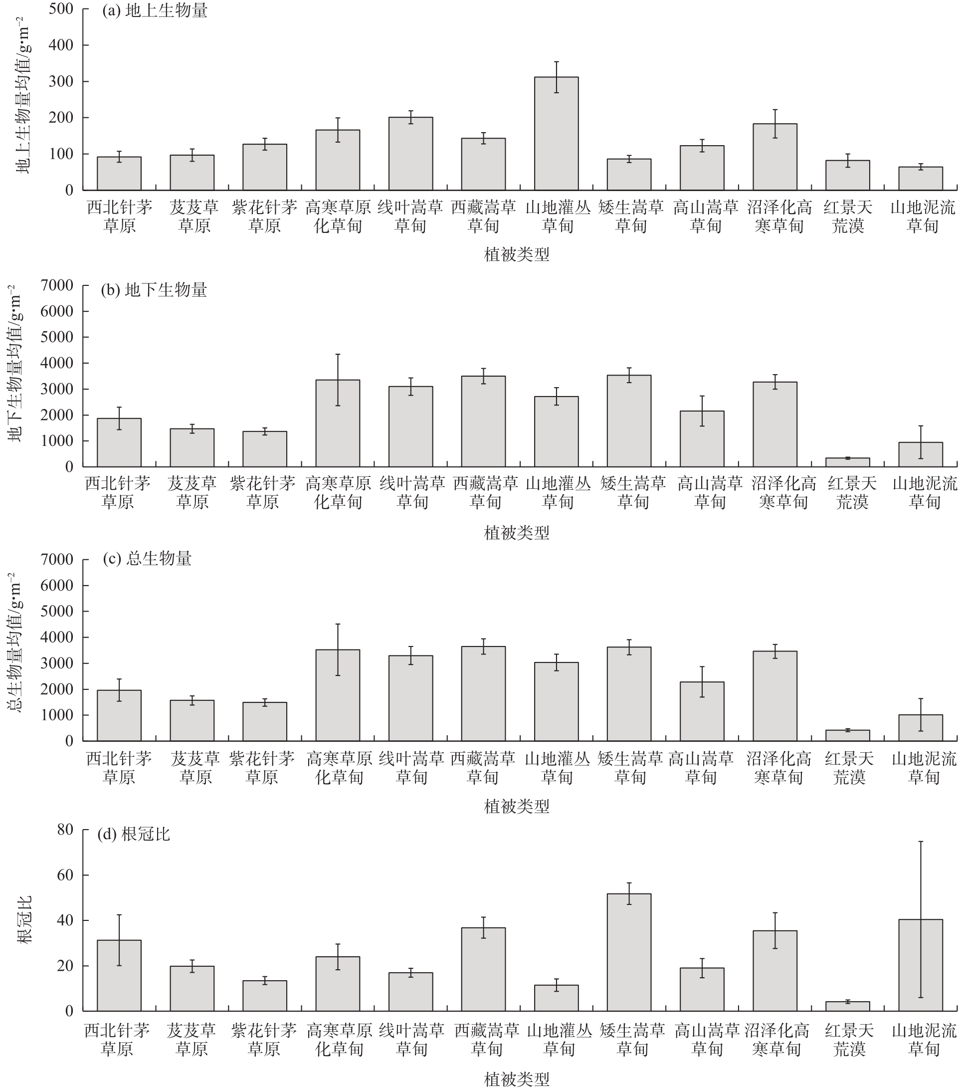
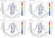
图4
青海湖流域草地植被生物量与根冠比的海拔和经纬度空间分布"

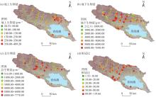
图5
青海湖流域草地植被生物量及根冠比空间分布"
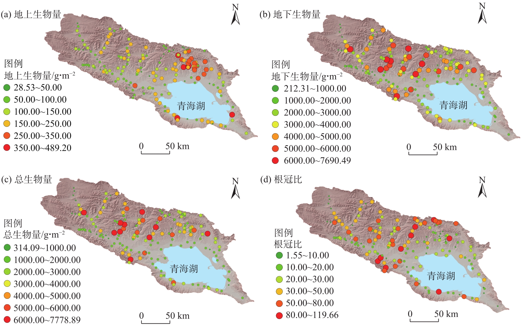
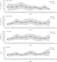
图6
青海湖流域不同海拔高度下草地植被生物量及根冠比分布特征"
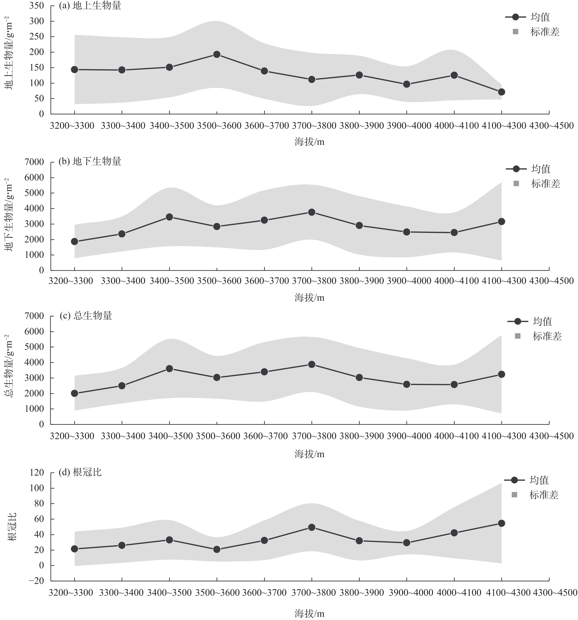
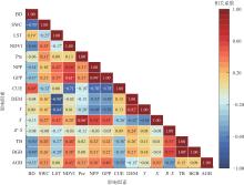
图7
青海湖流域草地植被生物量、根冠比与影响因素相关性分析 注:BD为土壤容重;SWC为土壤含水量;LST为地表温度;NDVI为归一化植被指数;Pre为降水量;NPP为净初级生产力;GPP为总初级生产力;CUE为生态系统碳利用效率;DEM为海拔;X为经度;Y为纬度;R∶S为根冠比;TB为总生物量;BGB为地下生物量;AGB为地上生物量;*为在0.05水平下显著相关。下同。"

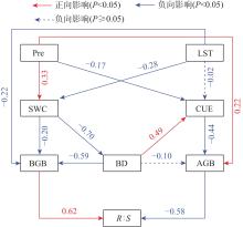
图8
青海湖流域草地植被生物量及其根冠比影响因素的路径分析"
表2
影响因素对青海湖流域草地植被地上和地下生物量的影响效应"
| 影响因素 | 总效益 | 直接效益 | 间接效益 | |||||
|---|---|---|---|---|---|---|---|---|
| 地上生物量 | 地下生物量 | 地上生物量 | 地下生物量 | 地上生物量 | 地下生物量 | |||
| 地表温度 | -0.05 | -0.28 | - | -0.22 | -0.05 | -0.06 | ||
| 降水量 | 0.36 | 0.07 | 0.22 | - | 0.15 | 0.07 | ||
| 土壤含水量 | 0.22 | 0.21 | - | -0.20 | 0.22 | 0.41 | ||
| 土壤容重 | -0.31 | -0.59 | -0.10 | -0.59 | -0.21 | - | ||
| 生态系统碳利用效率 | -0.44 | - | -0.44 | - | - | - | ||
| [1] | Ma H Z, Mo L D, Crowther T W, et al. The global distribution and environmental drivers of aboveground versus belowground plant biomass[J]. Nature Ecology & Evolution, 2021, 5: 1110-1122. |
| [2] | Dong S K, Li S, Xu Y D, et al. Different responses of alpine plants to natural climate change reduced coexistence through phenological niche overlap[J]. Science of the Total Environment, 2023, 892: 164522, doi: 10.1016/j.scitotenv.2023.164522. |
| [3] | 张俊怡, 刘廷玺, 罗艳云, 等. 半干旱草原型流域植被地上生物量时空分布特征及其影响因子[J]. 生态学杂志, 2020, 39(2): 364-375. |
| [Zhang Junyi, Liu Tingxi, Luo Yanyun, et al. Temporal and spatial distribution of aboveground biomass of vegetation and quantitative analysis of impact factors in semi-arid grassland basin[J]. Chinese Journal of Ecology, 2020, 39(2): 364-375.] | |
| [4] |
李康宁, 林伊琳, 赵俊三, 等. 三江源植被覆盖变化驱动机制及生态脆弱性分析[J]. 干旱区地理, 2025, 48(2): 283-295.
doi: 10.12118/j.issn.1000-6060.2024.324 |
|
[Li Kangning, Lin Yilin, Zhao Junsan, et al. Driving mechanisms of vegetation change and ecological vulnerability in the Three-River Headwater Region[J]. Arid Land Geography, 2025, 48(2): 283-295.]
doi: 10.12118/j.issn.1000-6060.2024.324 |
|
| [5] |
黄业芸, 邱开阳, 朱亚超, 等. 贺兰山不同海拔植被生物量与土壤分形特征和土壤水分的相关关系[J]. 草业学报, 2023, 32(12): 24-35.
doi: 10.11686/cyxb2023050 |
|
[Huang Yeyun, Qiu Kaiyang, Zhu Yachao, et al. Correlation between vegetation biomass and soil fractal characteristics and soil moisture at different elevations in the Helan Mountains[J]. Acta Prataculturae Sinica, 2023, 32(12): 24-35.]
doi: 10.11686/cyxb2023050 |
|
| [6] | 金云翔, 徐斌, 杨秀春, 等. 内蒙古锡林郭勒盟草原产草量动态遥感估算[J]. 中国科学: 生命科学, 2011, 41(12): 1185-1195. |
|
[Jin Yunxiang, Xu Bin, Yang Xiuchun, et al. Remote sensing dynamic estimation of grass production in Xilinguole, Inner Mongolia[J]. Scientia Sinica Vitae, 2011, 41(12): 1185-1195.]
doi: 10.1360/052011-228 |
|
| [7] | Garroutte E L, Hansen A J, Lawrence R L. Using NDVI and EVI to map spatiotemporal variation in the biomass and quality of forage for migratory elk in the Greater Yellowstone Ecosystem[J]. Remote Sensing, 2016, 8(5): 404, doi: 10.3390/rs8050404. |
| [8] |
Yan F, Wu B, Wang Y J. Estimating aboveground biomass in Mu Us Sandy Land using Landsat spectral derived vegetation indices over the past 30 years[J]. Journal of Arid Land, 2013, 5(4): 521-530.
doi: 10.1007/s40333-013-0180-0 |
| [9] | 陈哲, 汪浩, 王金洲, 等. 基于物候相机归一化植被指数估算高寒草地植物地上生物量的季节动态[J]. 植物生态学报, 2021, 45(5): 487-495. |
|
[Chen Zhe, Wang Hao, Wang Jinzhou, et al. Estimation on seasonal dynamics of alpine grassland aboveground biomass using phenology camera-derived NDVI[J]. Chinese Journal of Plant Ecology, 2021, 45(5): 487-495.]
doi: 10.17521/cjpe.2020.0076 |
|
| [10] | 高晓彤, 徐敏, 田海静, 等. 锡林郭勒盟草地地上生物量时空变化遥感诊断研究[J/OL]. 生态与农村环境学报. [2025-01-16].https://doi.org/10.19741/j.issn.1673-4831.2024.0877. |
| [Gao Xiaotong, Xu Min, Tian Haijing, et al. Remote sensing diagnosis of spatiotemporal changes in grassland above-ground biomass in Xilingol League[J/OL]. Journal of Ecology and Rural Environment. [2025-01-16]. https://doi.org/10.19741/j.issn.1673-4831.2024.0877.] | |
| [11] | Chen L, Ren C Y, Zhang B, et al. Estimation of forest above-ground biomass by geographically weighted regression and machine learning with sentinel imagery[J]. Forests, 2018, 9(10): 582, doi: 10.3390/f9100582. |
| [12] | 周景乐, 徐志高, 何旭升, 等. 草地地上生物量测量方法综述[J]. 中南林业调查规划, 2022, 41(2): 36-40. |
| [Zhou Jingle, Xu Zhigao, He Xusheng, et al. Review on methods of measuring grassland above-ground biomass[J]. Central South Forest Inventory and Planning, 2022, 41(2): 36-40.] | |
| [13] |
王婷, 周伟, 肖洁芸, 等. 基于遥感数据和机器学习算法的草地地上生物量估算研究[J]. 冰川冻土, 2023, 45(2): 753-762.
doi: 10.7522/j.issn.1000-0240.2023.0057 |
|
[Wang Ting, Zhou Wei, Xiao Jieyun, et al. Estimating the grassland aboveground biomass based on remote sensing data and machine learning algorithm[J]. Journal of Glaciology and Geocryology, 2023, 45(2): 753-762.]
doi: 10.7522/j.issn.1000-0240.2023.0057 |
|
| [14] |
芦光新, 陈秀蓉, 王军邦, 等. 气候变化对青藏高原高寒草地生态系统草丛-地境界面微生物的影响研究进展[J]. 草地学报, 2014, 22(2): 234-242.
doi: 10.11733/j.issn.1007-0435.2014.02.004 |
|
[Lu Guangxin, Chen Xiurong, Wang Junbang, et al. Research progresses on the effects of global change on the microbes of plant-site interface in alpine grassland ecosystem[J]. Acta Agrestia Sinica, 2014, 22(2): 234-242.]
doi: 10.11733/j.issn.1007-0435.2014.02.004 |
|
| [15] | Yang M X, Chen A, Zhang M, et al. Relationship between plant species diversity and aboveground biomass in alpine grasslands on the Qinghai-Tibet Plateau: Spatial patterns and the factors driving them[J]. Frontiers in Ecology and Evolution, 2023, 11: 1138884, doi: 10.3389/fevo.2023.1138884. |
| [16] | 张锦涛, 赵峰侠, 陈俊合, 等. 青藏高原不同类型高寒草地物种多样性与生物量的关系及影响要素[J]. 草业科学, 2023, 40(3): 616-626. |
| [Zhang Jintao, Zhao Fengxia, Chen Junhe, et al. Correlations of species diversity and biomass with environmental factors in alpine grasslands across the Qingzang Plateau[J]. Pratacultural Science, 2023, 40(3): 616-626.] | |
| [17] | 戴黎聪, 柯浔, 曹莹芳, 等. 青藏高原矮嵩草草甸地下和地上生物量分配格局及其与气象因子的关系[J]. 生态学报, 2019, 39(2): 486-493. |
| [Dai Licong, Ke Xun, Cao Yingfang, et al. Allocation patterns of above-and belowground biomass and its response to meteorological factors on an alpine meadow in Qinghai-Tibet Plateau[J]. Acta Ecologica Sinica, 2019, 39(2): 486-493.] | |
| [18] |
刘哲, 李奇, 陈懂懂, 等. 青藏高原高寒草甸物种多样性的海拔梯度分布格局及对地上生物量的影响[J]. 生物多样性, 2015, 23(4): 451-462.
doi: 10.17520/biods.2015043 |
|
[Liu Zhe, Li Qi, Chen Dongdong, et al. Patterns of plant species diversity along an altitudinal gradient and its effect on above-ground biomass in alpine meadows in Qinghai-Tibet Plateau[J]. Biodiversity Science, 2015, 23(4): 451-462.]
doi: 10.17520/biods.2015043 |
|
| [19] | 郝爱华, 薛娴, 尤全刚, 等. 基于BFAST模型的青藏高原典型草地植被变化特征[J]. 山西师范大学学报(自然科学版), 2024, 38(4): 42-52. |
| [Hao Aihua, Xue Xian, You Quangang, et al. Vegetation variation characteristics of typical grasslands on the Qinghai-Tibetan Plateau based on BFAST model[J]. Journal of Shanxi Normal University (Natural Science Edition), 2024, 38(4): 42-52.] | |
| [20] | 陈槐, 鞠佩君, 张江, 等. 青藏高原高寒草地生态系统变化的归因分析[J]. 科学通报, 2020, 65(22): 2406-2418. |
| [Chen Huai, Ju Peijun, Zhang Jiang, et al. Attribution analyses of changes in alpine grasslands on the Qinghai-Tibetan Plateau[J]. Chinese Science Bulletin, 2020, 65(22): 2406-2418.] | |
| [21] |
金哲人, 冯琦胜, 王瑞泾, 等. 基于MODIS数据与机器学习的青藏高原草地地上生物量研究[J]. 草业学报, 2022, 31(10): 1-17.
doi: 10.11686/cyxb2021386 |
|
[Jin Zheren, Feng Qisheng, Wang Ruijing, et al. A study of grassland aboveground biomass on the Tibetan Plateau using MODIS data and machine learning[J]. Acta Prataculturae Sinica, 2022, 31(10): 1-17.]
doi: 10.11686/cyxb2021386 |
|
| [22] | 张菊. 青藏高原高寒草地地上生物量反演及时空变化研究[D]. 成都: 成都理工大学, 2021. |
| [Zhang Ju. Estimation of alpine grassland aboveground biomass and its dynamics variations characteristics in the Qinghai-Tibet Plateau[D]. Chengdu: Chengdu University of Technology, 2021.] | |
| [23] |
Yan L, Li Y, Wang L, et al. Grazing significantly increases root shoot ratio but decreases soil organic carbon in Qinghai-Tibetan Plateau grasslands: A hierarchical meta-analysis[J]. Land Degradation & Development, 2020, 31: 2369-2378.
doi: 10.1002/ldr.v31.16 |
| [24] | Li M, Zhang X Z, Wu J S, et al. Declining human activity intensity on alpine grasslands of the Tibetan Plateau[J]. Journal of Environmental Management, 2021, 296: 113198, doi: 10.1016/j.jenvman.2021.113198. |
| [25] | Zhang J, Fang S B, Liu H H. Estimation of alpine grassland above-ground biomass and its response to climate on the Qinghai-Tibet Plateau during 2001 to 2019[J]. Global Ecology and Conservation, 2022, 35: e02065, doi: 10.1016/j.gecco.2022.e02065. |
| [26] | 陈巧娥, 周继华, 来利明, 等. 青藏高原植被时空分布变化特征及驱动因素[J]. 应用与环境生物学报, 2025, 31(3): 322-335. |
| [Chen Qiao’e, Zhou Jihua, Lai Liming, et al. Spatiotemporal distribution change of vegetation and driving factors on the Qinghai-Xizang Plateau[J]. Chinese Journal Applied and Environmental Biology, 2025, 31(3): 322-335.] | |
| [27] | 林伟山, 德科加, 向雪梅, 等. 青藏高原退化高寒草甸植被群落与土壤养分变化特征[J]. 草原与草坪, 2025, 45(2): 14-23. |
| [Lin Weishan, De Kejia, Xiang Xuemei, et al. Changes of vegetation community and soil nutrients in degraded alpine meadows on the Qinghai-Tibet Plateau[J]. Grassland and Turf, 2025, 45(2): 14-23.] | |
| [28] | 侯威. 青海湖流域生态环境地质条件与生态环境地质问题研究[D]. 北京: 中国地质大学, 2020. |
| [Hou Wei. Research on the geological condition of the ecological environment in Qinghai Lake area[D]. Beijing: China University of Geosciences, 2020.] | |
| [29] | 武彦朋, 陈克龙, 张斐, 等. 青海湖内陆高寒湿地物种多样性和地上生物量的关系[J]. 水土保持通报, 2011, 31(1): 76-80. |
| [Wu Yanpeng, Chen Kelong, Zhang Fei, et al. Relationship between species diversity and above-ground biomass of inland alpine wetlands of Qinghai Lake[J]. Bulletin of Soil and Water Conservation, 2011, 31(1): 76-80.] | |
| [30] |
胡樱, 王慧春, 李正科, 等. 青海湖流域沙地植物群落多样性研究[J]. 草地学报, 2022, 30(10): 2782-2790.
doi: 10.11733/j.issn.1007-0435.2022.10.029 |
|
[Hu Ying, Wang Huichun, Li Zhengke, et al. Plant community diversity in sandy land of Qinghai Lake Basin[J]. Acta Agrestia Sinica, 2022, 30(10): 2782-2790.]
doi: 10.11733/j.issn.1007-0435.2022.10.029 |
|
| [31] | 张莉, 郭龙欣, 张铭洋, 等. 青海湖高寒草原植被群落结构和水源涵养功能对禁牧封育的响应[J]. 西北植物学报, 2024, 44(9): 1488-1498. |
| [Zhang Li, Guo Longxin, Zhang Mingyang, et al. Response of plant community structure and soil water conservation function to forbidden grazing and enclosure in alpine steppe of the Qinghai Lake[J]. Acta Botanica Boreali-Occidentalia Sinica, 2024, 44(9): 1488-1498.] | |
| [32] |
蔡海, 史倩倩, 王婷, 等. 青海湖围栏封育下温性荒漠植被群落长期变化特征[J]. 草地学报, 2025, 33(3): 929-935.
doi: 10.11733/j.issn.1007-0435.2025.03.027 |
|
[Cai Hai, Shi Qianqian, Wang Ting, et al. Impact of fencing on the characteristics of the temperate desert vegetation community in the Qinghai Lake Basin[J]. Acta Agrestia Sinica, 2025, 33(3): 929-935.]
doi: 10.11733/j.issn.1007-0435.2025.03.027 |
|
| [33] |
李芳, 王广军, 杜海波, 等. 融合MODIS和Landsat数据的青海湖流域典型区NDVI重构与年内最大值变化分析[J]. 草业学报, 2023, 32(8): 28-39.
doi: 10.11686/cyxb2022385 |
|
[Li Fang, Wang Guangjun, Du Haibo, et al. Integrating MODIS and Landsat data to reconstruct the Landsat NDVI of a typical region in the Qinghai Lake Basin and changes in the intra-annual NDVI maximum[J]. Acta Prataculturae Sinica, 2023, 32(8): 28-39.]
doi: 10.11686/cyxb2022385 |
|
| [34] | 石建丽, 仲俊涛, 马勇洁. 青海湖流域草地植被与物种多样性空间分异研究[J]. 草原与草坪, 2024, 44(3): 19-25. |
| [Shi Jianli, Zhong Juntao, Ma Yongjie. Spatial differentiation of grassland vegetation and species diversity in Qinghai Lake Basin[J]. Grassland and Turf, 2024, 44(3): 19-25.] | |
| [35] |
Ma Y J, Li X Y, Liu L, et al. Evapotranspiration and its dominant controls along an elevation gradient in the Qinghai Lake watershed, northeast Qinghai-Tibet Plateau[J]. Journal of Hydrology, 2019, 575: 257-268.
doi: 10.1016/j.jhydrol.2019.05.019 |
| [36] | 刘玉萍, 周勇辉, 苏旭, 等. 青海湖区不同植被类型草原土壤养分分布特征[J]. 兰州大学学报(自然科学版), 2018, 54(4): 480-485, 493. |
| [Liu Yuping, Zhou Yonghui, Su Xu, et al. Differentiation characteristics of soil nutrients in steppe of different vegetation types in the zone of the Qinghai Lake[J]. Journal of Lanzhou University (Natural Sciences), 2018, 54(4): 480-485, 493.] | |
| [37] | 中华人民共和国农业部. 草地分类: NY/T 2997—2016[S]. 北京: 中国农业出版社, 2016. |
| [Ministry of Agriculture of the People’s Republic of China. Grassland classification: NY/T 2997—2016[S]. Beijing: China Agriculture Press, 2016.] | |
| [38] | 许伟林, 马思锦, 罗银飞, 等. 青海湖流域生态环境地质[M]. 武汉: 中国地质大学出版社, 2019: 114-123. |
| [Xu Weilin, Ma Sijin, Luo Yinfei, et al. Eco-environmental geology of Qinghai Lake Basin[M]. Wuhan: China University of Geosciences Press, 2019: 114-123.] | |
| [39] |
Scurlock J M O, Johnson K, Olson R J. Estimating net primary productivity from grassland biomass dynamics measurements[J]. Global Change Biology, 2002, 8(8): 736-753.
doi: 10.1046/j.1365-2486.2002.00512.x |
| [40] | 孙磊, 李斌奇, 刘萍, 等. 不同海拔高寒草甸地下生物量分配格局研究[J]. 高原农业, 2018, 2(6): 589-593, 617. |
| [Sun Lei, Li Binqi, Liu Ping, et al. Distribution pattern of underground biomass in alpine meadow with different altitudes[J]. Journal of Plateau Agriculture, 2018, 2(6): 589-593, 617.] | |
| [41] | 鲁如坤. 土壤农业化学分析方法[M]. 北京: 中国农业科技出版社, 2000: 9-10. |
| [Lu Rukun. Methods for soil agro-chemical analysis[M]. Beijing: China Agricultural Science and Technology Press, 2000: 9-10.] | |
| [42] | Dane J H, Topp G C. Methods of soil analysis. Part 4. Physical methods[M]. Madison: Soil Science Society of America, 2002: 201-228. |
| [43] | Buchholtz K P. The underground organs of herbage grasses[J]. Agronomy Journal, 1957, 49(9): 522-522. |
| [44] | 鲍士旦. 土壤农化分析(第3版)[M]. 北京: 中国农业出版社, 2000: 12-14. |
| [Bao Shidan. Soil agro-chemical analysis (3rd ed.)[M]. Beijing: China Agriculture Press, 2000: 12-14.] | |
| [45] |
Delucia E H, Drake J E, Thomas R B, et al. Forest carbon use efficiency: Is respiration a constant fraction of gross primary production?[J]. Global Change Biology, 2007, 13: 1157-1167.
doi: 10.1111/gcb.2007.13.issue-6 |
| [46] | 徐建华. 现代地理学中的数学方法(第3版)[M]. 北京: 高等教育出版社, 2017: 73-83. |
| [Xu Jianhua. Mathematical methods in contemporary geography (3rd ed.)[M]. Beijing: Higher Education Press, 2017: 73-83.] | |
| [47] | 张芊妤, 曾奕丰, 李文洁, 等. 季节放牧下青藏高原高寒草甸牧草生物量空间分布特征[J]. 草业科学, 2022, 39(2): 318-327. |
| [Zhang Qianyu, Zeng Yifeng, Li Wenjie, et al. Effects of seasonal grazing on spatial distribution characteristics of forage biomass in an alpine meadow on the Qinghai-Tibet Plateau[J]. Pratacultural Science, 2022, 39(2): 318-327.] | |
| [48] | 姚雨微, 任鸿瑞. 青藏高原草地地上生物量估算[J]. 生态学报, 2024, 44(7): 3049-3059. |
| [Yao Yuwei, Ren Hongrui. Estimation of grassland aboveground biomass on the Qinghai-Tibet Plateau[J]. Acta Ecologica Sinica, 2024, 44(7): 3049-3059.] | |
| [49] | Li P X, Zhu W Q, He B K. Regional differences in the impact paths of climate on aboveground biomass in alpine grasslands across the Qinghai-Tibet Plateau[J]. Science of the Total Environment, 2024, 947: 174421, doi: 10.1016/j.scitotenv.2024.174421. |
| [50] |
张双印, 赵保成, 赵登忠, 等. 长江源草地生物量空间分布及分配初步研究[J]. 长江科学院院报, 2024, 41(11): 196-202.
doi: 10.11988/ckyyb.20230479 |
|
[Zhang Shuangyin, Zhao Baocheng, Zhao Dengzhong, et al. Spatial distribution and allocation of grassland biomass in the headwaters of the Yangtze River[J]. Journal of Yangtze River Scientific Research Institute, 2024, 41(11): 196-202.]
doi: 10.11988/ckyyb.20230479 |
|
| [51] | Zhu X Y, Hou J H, Li M X, et al. High-resolution spatial distribution of vegetation biomass and its environmental response on Qinghai-Tibet Plateau: Intensive grid-field survey[J]. Ecological Indicators, 2023, 149: 110167, doi: 10.1016/j.ecolind.2023.110167. |
| [52] | 苟小林, 周青平, 涂卫国, 等. 高寒半湿润沙地土壤水分与根系生物量对植被恢复的响应[J]. 中国草地学报, 2022, 44(7): 53-60, 86. |
| [Gou Xiaolin, Zhou Qingping, Tu Weiguo, et al. Response of soil water content and root biomass to vegetation restoration in alpine semi-humid sandy land[J]. Chinese Journal of Grassland, 2022, 44(7): 53-60, 86.] | |
| [53] | 王采娥, 黄梅, 王文银, 等. 三江源区高寒坡地退化植物群落多样性和地上生物量沿海拔梯度的变化特征[J]. 生态学报, 2022, 42(9): 3640-3655. |
| [Wang Cai’e, Huang Mei, Wang Wenyin, et al. Variation characteristics of plant community diversity and above-ground biomass in alpine degraded slopes along altitude gradients in the headwaters region of three-river on Tibetan Plateau[J]. Acta Ecologica Sinica, 2022, 42(9): 3640-3655.] | |
| [54] | Ge J, Hou M J, Liang T G, et al. Spatiotemporal dynamics of grassland aboveground biomass and its driving factors in north China over the past 20 years[J]. Science of the Total Environment, 2022, 826: 154226, doi: 10.1016/j.scitotenv.2022.154226. |
| [55] |
Bai Y, Wu J, Pan Q, et al. Positive linear relationship between productivity and diversity: Evidence from the Eurasian steppe[J]. Journal of Applied Ecology, 2007, 44: 1023-1034.
doi: 10.1111/jpe.2007.44.issue-5 |
| [56] | Jarque-Bascuñana L, Calleja J A, Ibañez M, et al. Grazing influences biomass production and protein content of alpine meadows[J]. Science of the Total Environment, 2022, 818: 151771, doi: 10.1016/j.scitotenv.2021.151771. |
| [57] | 周美林, 刘家宏, 刘希胜, 等. 青海湖流域植被动态变化驱动力及空间粒度效应[J]. 中国环境科学, 2024, 44(3): 1497-1506. |
| [Zhou Meilin, Liu Jiahong, Liu Xisheng, et al. Analysis of driving forces and spatial scale effects on vegetation dynamics in the Qinghai Lake Basin[J]. China Environmental Science, 2024, 44(3): 1497-1506.] | |
| [58] |
张晓东, 马风华, 赵志鹏, 等. 宁夏中部荒漠草原防沙治沙区NDVI时空演化特征及其对气候因素的响应[J]. 干旱区地理, 2025, 48(10): 1804-1814.
doi: 10.12118/j.issn.1000-6060.2024.782 |
|
[Zhang Xiaodong, Ma Fenghua, Zhao Zhipeng, et al. Spatio-temporal evolution characteristics of NDVI and its response to climate factors of desertification prevention and control zone in the desert grasslands of central Ningxia[J]. Arid Land Geography, 2025, 48(10): 1804-1814.]
doi: 10.12118/j.issn.1000-6060.2024.782 |
|
| [59] | Zhou L Y, Hong Y, Li C H, et al. Responses of biomass allocation to multi-factor global change: A global synthesis[J]. Agriculture, Ecosystems & Environment, 2020, 304: 107115, doi: 10.1016/j.agee.2020.107115. |
| [60] | 杜志勇, 丛楠. 植被与土壤特征对青藏高原不同程度退化草地的响应[J]. 生态学报, 2024, 44(6): 2504-2516. |
| [Du Zhiyong, Cong Nan. Responses of vegetation and soil characterisitics to degraded grassland under different degrees on the Qinghai-Tibet Plateau[J]. Acta Ecologica Sinica, 2024, 44(6): 2504-2516.] | |
| [61] |
Liu H Y, Wang H, Li N, et al. Phenological mismatches between above-and belowground plant responses to climate warming[J]. Nature Climate Change, 2022, 12: 97-102.
doi: 10.1038/s41558-021-01244-x |
| [62] | Chen Y S, Zhang S H, Wang Y D. Spatial distribution patterns and drivers of above-and below-ground biomass in Chinese terrestrial ecosystems[J]. Science of the Total Environment, 2024, 944: 173922, doi: 10.1016/j.scitotenv.2024.173922. |
| [63] | Wei Y Q, Lu H Y, Wang J N, et al. Dual influence of climate change and anthropogenic activities on the spatiotemporal vegetation dynamics over the Qinghai-Tibetan Plateau from 1981 to 2015[J]. Earth’s Future, 2022, 10: e2021EF002566, doi: 10.1029/2021EF002566. |
| [64] | 武亚堂. 青藏高原草地生产能力模拟与时空格局研究[D]. 兰州: 甘肃农业大学, 2024. |
| [Wu Yatang. Simulation of grassland production capacity and study of spatiotemporal patterns in the Tibet[D]. Lanzhou: Gansu Agricultural University, 2024.] |
| [1] | 杨迪, 邹进, 马晓飞, 张珣, 周锐, 刘艳春, 石金莲. 体育旅游资源空间分布特征及可持续发展研究——以新疆为例[J]. 干旱区地理, 2026, 49(1): 140-150. |
| [2] | 张少华, 关海玲. 创新集聚空间分布模式对中国城市经济韧性的影响机制研究[J]. 干旱区地理, 2025, 48(9): 1636-1647. |
| [3] | 张毅明, 汤宇磊, 冯俊波. 基于随机森林模型的青藏高原冰川预测及分析[J]. 干旱区地理, 2025, 48(8): 1342-1352. |
| [4] | 田志馥, 于亚娟, 黄辰宇. 基于POI数据挖掘的内蒙古县域旅游要素空间分布特征及影响因素[J]. 干旱区地理, 2025, 48(7): 1255-1266. |
| [5] | 郭念发, 王录仓. 兰州市主城区幼儿园入学可达性及影响因素分析[J]. 干旱区地理, 2025, 48(6): 1043-1054. |
| [6] | 李梦园, 庞家朋, 李欢. 省域典型旅游集散地综合可达性协调发展及空间关系研究——以新疆为例[J]. 干旱区地理, 2025, 48(3): 539-548. |
| [7] | 李珂, 何静, 孟阳阳, 李昌睿. 黄河流域乡村旅游重点村空间分布及影响因素[J]. 干旱区地理, 2025, 48(11): 2031-2041. |
| [8] | 朱磊, 李燕楠, 徐佳慧, 胡静, 朱芳, 梁茫茫. 中国冰雪旅游地空间分布格局及成因[J]. 干旱区地理, 2024, 47(8): 1399-1410. |
| [9] | 陈聪, 唐英, 史承勇, 杜怡帆, 赵丽娜, 姜旭妍. 黄河流域遗产资源空间分布与区域协同保护[J]. 干旱区地理, 2024, 47(7): 1220-1232. |
| [10] | 张志明, 孙小妹, 包段红, 姚宝辉, 王志成, 苏军虎. 祁连山北麓荒漠草原5种优势植物生物量与土壤养分特征[J]. 干旱区地理, 2024, 47(4): 662-671. |
| [11] | 王安琪, 张钰, 刘佳伟, 赵威, 刘馨雨, 李凯. 新疆甘家湖梭梭林国家级自然保护区植被群落多样性及空间分布格局[J]. 干旱区地理, 2024, 47(11): 1841-1851. |
| [12] | 江岳坤, 石鹏娟. 中国市域城乡收入差距时空演化及影响因素[J]. 干旱区地理, 2024, 47(1): 147-157. |
| [13] | 黄鑫, 焦黎, 马晓飞, 王勇辉, 阿尔曼·阿布拉. 基于RClimDex模型的近60 a中亚极端降水事件变化特征[J]. 干旱区地理, 2023, 46(7): 1039-1051. |
| [14] | 康利刚, 曹生奎, 曹广超, 严莉, 陈链璇, 李文斌, 赵浩然. 青海湖流域地表温度时空变化特征研究[J]. 干旱区地理, 2023, 46(7): 1084-1097. |
| [15] | 潘雪, 关宇淇, 潘占东, 刘杰, 蔡立群, 董博, 杜健. 干旱区耕地质量等级时空变化及其评价——以西宁市为例[J]. 干旱区地理, 2023, 46(5): 793-803. |
|
||