- 2025年8月14日 星期四
干旱区地理 ›› 2023, Vol. 46 ›› Issue (7): 1084-1097.doi: 10.12118/j.issn.1000-6060.2022.525 cstr: 32274.14.ALG2022525
康利刚1,2( ),曹生奎1,2,3(),曹广超1,2,3,严莉1,2,陈链璇1,2,李文斌1,2,赵浩然1,2
收稿日期:2022-10-15
修回日期:2023-01-03
出版日期:2023-07-25
发布日期:2023-08-03
作者简介:康利刚(1998-),男,硕士研究生,主要从事生态水文与水资源学方面的研究. E-mail: 基金资助:
KANG Ligang1,2(),CAO Shengkui1,2,3(),CAO Guangchao1,2,3,YAN Li1,2,CHEN Lianxuan1,2,LI Wenbin1,2,ZHAO Haoran1,2
Received:2022-10-15
Revised:2023-01-03
Published:2023-07-25
Online:2023-08-03
摘要:
地表温度是陆面过程研究的重要参数之一。基于MOD11A2地表温度数据,结合数字高程模型(DEM)、土地利用类型、气象和归一化植被指数(NDVI)等数据,采用ArcGIS空间分析与数理统计方法,对2002—2021年青海湖流域的年度、季节、月份及昼夜等时间尺度,以及不同土地利用类型、不同海拔高度的地表温度变化特征进行了分析,并利用地理探测器模型对地表温度与环境因子之间的关系进行了研究。结果表明:(1)青海湖流域年均地表温度总体随年份增加呈现上升趋势,平均地表温度为2.20 ℃。空间分布呈现比较规律的由流域东南向西北逐渐下降的特征。青海湖北岸和东岸地表温度上升趋势最显著,呈上升趋势的区域占流域主体。(2)地表温度在不同季节表现为:夏季>春季>秋季>冬季。除春季随年份增加呈下降趋势外,夏季、秋季、冬季均呈逐年上升趋势。(3)月间地表温度表现为规律的先增加后减小,以7月为“对称轴”呈显著相似的变化趋势。(4)不同土地利用类型的地表温度从高到低排序为:耕地>林地>灌木>草地>荒地>冰川。(5)年均地表温度与海拔为显著负相关关系(P<0.05),海拔每升高100 m,年均地表温度下降约0.8 ℃。(6)根据单因子探测结果,环境因子对地表温度的解释力存在差异,其中海拔高度和年均气温对地表温度的解释力较高,而土地利用类型对其解释力最低。在所有因子的交互作用中,年均气温和海拔高度交互,q值的解释力最大(0.90),表明年均气温和海拔高度的耦合与青海湖流域地表温度关系密切。
康利刚, 曹生奎, 曹广超, 严莉, 陈链璇, 李文斌, 赵浩然. 青海湖流域地表温度时空变化特征研究[J]. 干旱区地理, 2023, 46(7): 1084-1097.
KANG Ligang, CAO Shengkui, CAO Guangchao, YAN Li, CHEN Lianxuan, LI Wenbin, ZHAO Haoran. Spatiotemporal variation of land surface temperature in Qinghai Lake Basin[J]. Arid Land Geography, 2023, 46(7): 1084-1097.
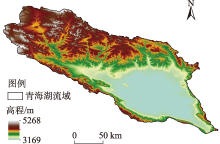
图1
研究区示意图"


图2
青海湖流域地表温度年际变化"
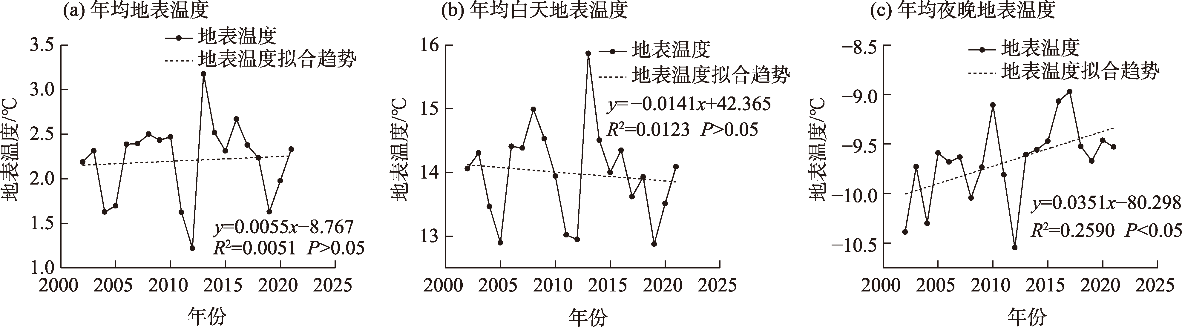

图3
青海湖流域地表温度及其年际变化率空间分布"
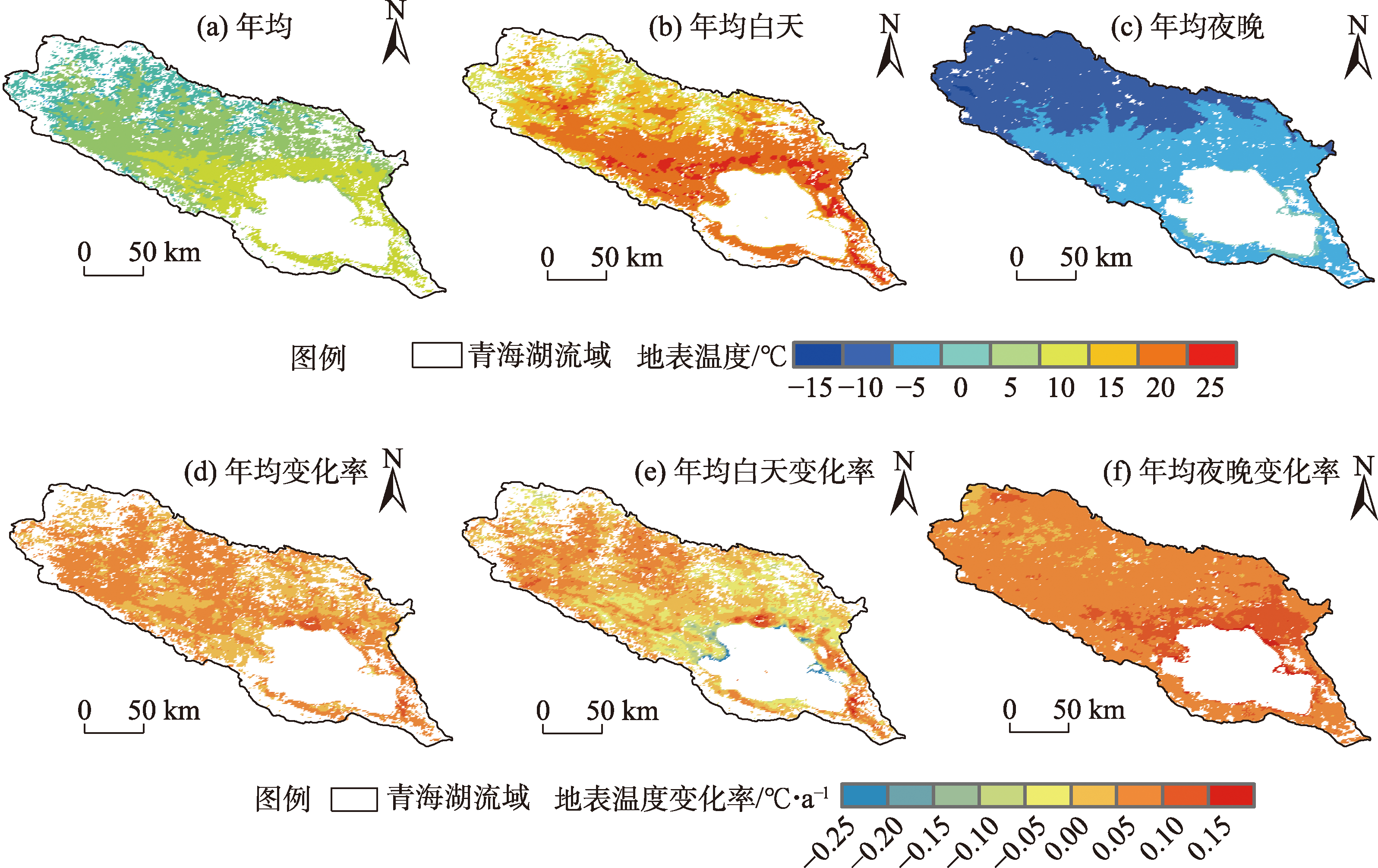
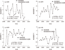
图4
青海湖流域季均地表温度年际变化"

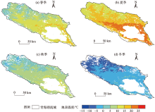
图5
青海湖流域季均地表温度空间分布"

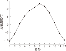
图6
青海湖流域地表温度年内变化"
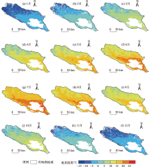
图7
青海湖流域月均地表温度空间分布"

表1
青海湖流域不同土地利用类型的地表温度变化"
| 地表温度 | 2002年 | 2007年 | 2012年 | 2017年 | 2020年 | 年均 | 年均白天 | 年均夜晚 |
|---|---|---|---|---|---|---|---|---|
| 耕地 | 4.52 | 4.97 | 4.5 | 5.05 | 5.22 | 5.19 | 17.43 | -7.02 |
| 林地 | 3.43 | 3.38 | 2.13 | 3.47 | 3.96 | 3.63 | 13.2 | -7.17 |
| 灌木 | 3.21 | 3.16 | 2.01 | 3.28 | 2.89 | 3.31 | 14.27 | -7.29 |
| 草地 | 2.48 | 2.65 | 1.44 | 2.61 | 2.21 | 2.89 | 15.26 | -9.68 |
| 冰川 | -6.72 | -7.43 | -8.05 | -7.12 | -7.17 | -7.63 | 0.23 | -15.59 |
| 荒地 | -1.24 | -0.99 | -2.05 | -0.81 | -1.25 | -0.11 | 11.58 | -12.03 |
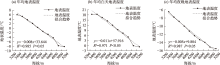
图8
青海湖流域不同海拔的年均、年均白天、年均夜晚地表温度变化"

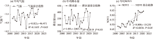
图9
青海湖流域年均气温、年均降水量、年均NDVI年际变化 注:NDVI为归一化植被指数。下同。"
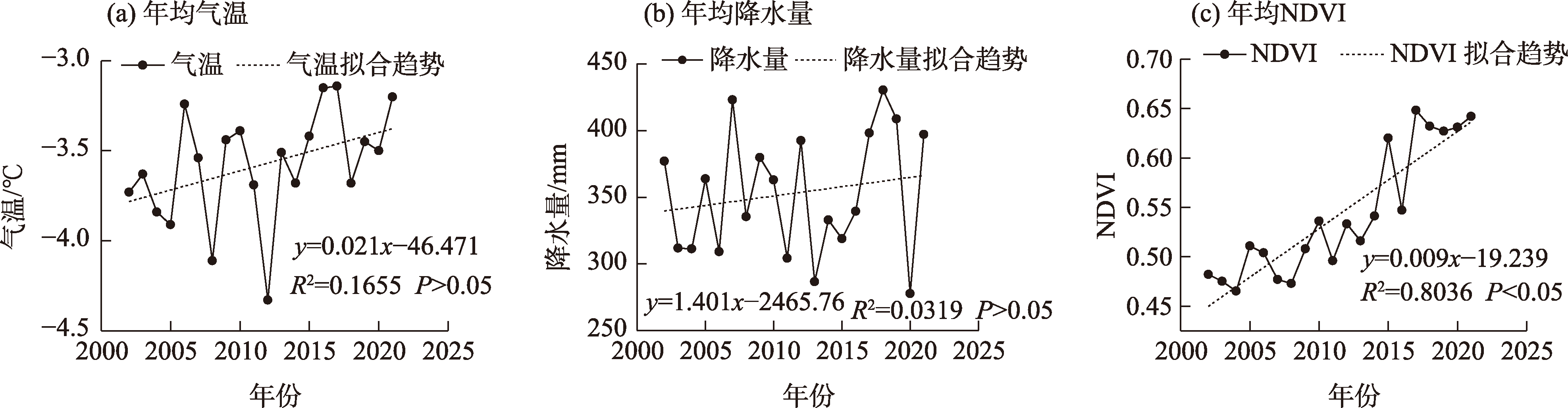
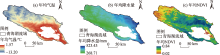
图10
青海湖流域年均气温、年均降水量、年均NDVI空间分布"

表2
青海湖流域年均地表温度、年均气温、年均降水量、年均NDVI全局空间自相关性统计"
| 环境因子 | Moran’s I指数 | Z得分 | P值 |
|---|---|---|---|
| 年均地表温度 | 0.70 | 67.83 | 0.000 |
| 年均气温 | 0.80 | 77.46 | 0.000 |
| 年均降水量 | 0.89 | 86.26 | 0.000 |
| 年均NDVI | 0.57 | 54.79 | 0.000 |
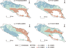
图11
青海湖流域年均地表温度、年均气温、年均降水量、年均NDVI空间聚集情况"

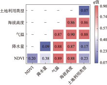
图12
影响因子交互作用探测结果 注: q为自变量解释力的度量。"

| [1] | 张祎. 长江流域土地利用/覆被变化对地表温度的影响[D]. 武汉: 中国地质大学, 2018. |
| [Zhang Yi. The influence of LUCC on the land surface temperature in Yangtze River Basin[D]. Wuhan: China University of Geosciences, 2018.] | |
| [2] |
刘俊杰, 潘自武, 秦奋, 等. 基于MODIS的秦巴山地气温估算与山体效应分析[J]. 地理研究, 2020, 39(3): 735-748.
doi: 10.11821/dlyj020190164 |
|
[Liu Junjie, Pan Ziwu, Qin Fen, et al. Estimation of air temperature based on MODIS and analysis of mass elevation effect in the Qinling-Daba Mountains[J]. Geographical Research, 2020, 39(3): 735-748.]
doi: 10.11821/dlyj020190164 |
|
| [3] | 安彬, 肖薇薇, 张淑兰, 等. 1960—2017年黄土高原地表温度时空变化特征[J]. 干旱区地理, 2021, 44(3): 778-785. |
| [An Bin, Xiao Weiwei, Zhang Shulan, et al. Spatial and temporal characteristics of surface temperature in the Loess Plateau during 1960—2017[J]. Arid Land Geography, 2021, 44(3): 778-785.] | |
| [4] |
Delnat V, Verborgt J, Janssens L, et al. Daily temperature variation lowers the lethal and sublethal impact of a pesticide pulse due to a higher degradation rate[J]. Chemosphere, 2021, 263: 128114, doi: 10.1016/j.chemosphere.2020.128114.
doi: 10.1016/j.chemosphere.2020.128114 |
| [5] | IPCC. Summary for policy makers of the synthesis report of the IPCC fifth assessment report[M]. Cambridge: Cambridge University Press, 2013. |
| [6] |
Ethan H, Kirsten M B, Braden C O, et al. Evaluation of the MODIS collections 5 and 6 for change analysis of vegetation and land surface temperature dynamics in north and south America[J]. ISPRS Journal of Photogrammetry and Remote Sensing, 2019, 156: 121-134.
doi: 10.1016/j.isprsjprs.2019.07.011 |
| [7] |
姬霖, 段克勤. 1960—2017年渭河流域极端气温变化及其对区域增暖的响应[J]. 地理科学, 2020, 40(3): 466-477.
doi: 10.13249/j.cnki.sgs.2020.03.015 |
|
[Ji Lin, Duan Keqin. Variations of extreme temperature and its response on regional warming in the Weihe River Basin during 1960—2017[J]. Scientia Geographica Sinica, 2020, 40(3): 466-477.]
doi: 10.13249/j.cnki.sgs.2020.03.015 |
|
| [8] | 丁一汇, 王会军. 近百年中国气候变化科学问题的新认识[J]. 科学通报, 2016, 61(10): 1029-1041. |
| [Ding Yihui, Wang Huijun. Newly acquired knowledge on the scientific issues related to climate change over the recent 100 years in China[J]. Chinese Science Bulletin, 2016, 61(10): 1029-1041.] | |
| [9] |
热伊莱·卡得尔, 玉苏甫·买买提, 玉素甫江·如素力, 等. 伊犁河谷2001—2014年地表温度时空分异特征[J]. 中国沙漠, 2018, 38(3): 637-644.
doi: 10.7522/j.issn.1000-694X.2017.00012 |
|
[Kadeer Reyilai, Maimaiti Yusufu, Rusuli Yusufujiang, et al. Temporal and spatial differentiation characteristics of surface temperature in Yili Valley from 2001 to 2014[J]. Journal of Desert Research, 2018, 38(3): 637-644.]
doi: 10.7522/j.issn.1000-694X.2017.00012 |
|
| [10] | 张威, 纪然. 辽宁省地表温度时空变化及影响因素[J]. 生态学报, 2019, 39(18): 6772-6784. |
| [Zhang Wei, Ji Ran. Analysis of spatiotemporal variation and factors influencing surface temperature in Liaoning Province[J]. Acta Ecologica Sinica, 2019, 39(18): 6772-6784.] | |
| [11] |
叶钰, 秦建新, 胡顺石. 长沙市热岛效应时空特征变化研究[J]. 地球信息科学学报, 2017, 19(4): 518-527.
doi: 10.3724/SP.J.1047.2017.00518 |
|
[Ye Yu, Qin Jianxin, Hu Shunshi. Spatial-temporal evolution of urban heat island effects in Changsha City[J]. Journal of Geo-information Science, 2017, 19(4): 518-527.]
doi: 10.3724/SP.J.1047.2017.00518 |
|
| [12] | 刘劲宏, 姚宜斌, 桑吉章. PM2.5对地表温度的影响及其应用[J]. 大地测量与地球动力学, 2019, 39(5): 502-505. |
| [Liu Jinhong, Yao Yibin, Sang Jizhang. Influence of PM2.5concentrations on surface temperature and its application[J]. Journal of Geodesy and Geodynamics, 2019, 39(5): 502-505.] | |
| [13] | 王万同, 王卷乐, 杜佳. 基于ETM+与MODIS数据融合的伊洛河流域地表蒸散估算[J]. 地理研究, 2013, 32(5): 817-827. |
| [Wang Wantong, Wang Juanle, Du Jia. Land surface evapotranspiration estimation of Yiluo River Basin based on fusion of ETM+ and MODIS data[J]. Geographical Research, 2013, 32(5): 817-827.] | |
| [14] | 刘宝康. 气候变化背景下青海湖流域草地与湖泊时空变化特征研究[D]. 兰州: 兰州大学, 2016. |
| [Liu Baokang. Spatial and temporal variation characteristics of grassland and lake in Qinghai Lake Basin under climate change[D]. Lanzhou: Lanzhou University, 2016.] | |
| [15] |
李广泳, 姜翠红, 程滔, 等. 青海湖流域植被物候格局时空动态变化及其与植被退化的关系[J]. 草业学报, 2016, 25(1): 22-32.
doi: 10.11686/cyxb2015210 |
|
[Li Guangyong, Jiang Cuihong, Cheng Tao, et al. Spatial-temporal variation of vegetation phenology and their relationships with vegetation degradation in a Qinghai Lake watershed[J]. Acta Prataculturae Sinica, 2016, 25(1): 22-32.]
doi: 10.11686/cyxb2015210 |
|
| [16] | 赵美亮, 曹广超, 曹生奎, 等. 1980—2017年青海省地表温度时空变化特征[J]. 干旱区研究, 2021, 38(1): 178-187. |
| [Zhao Meiliang, Cao Guangchao, Cao Shengkui, et al. Spatial-temporal variation characteristics of land surface temperature in Qinghai Province from 1980 to 2017[J]. Arid Zone Research, 2021, 38(1): 178-187.] | |
| [17] | 韩有香, 刘金青. 1963—2016年久治地区日照时数变化特征分析[J]. 现代农业科技, 2017(21): 233-236. |
| [Han Youxiang, Liu Jinqing. Analysis on the change characteristics of sunshine hours in Jiuzhi from 1963 to 2016[J]. Modern Agricultural Science and Technology, 2017(21): 233-236.] | |
| [18] |
杨羽帆, 曹生奎, 冯起, 等. 青海湖沙柳河流域浅层地下水氢氧稳定同位素分布特征[J]. 中国沙漠, 2019, 39(5): 45-53.
doi: 10.7522/j.issn.1000-694X.2018.00101 |
|
[Yang Yufan, Cao Shengkui, Feng Qi, et al. Spatial distribution characteristics of composition of stable hydrogen and oxygen isotopes of shallow groundwater in Shaliu River Basin of Qinghai Lake[J]. Journal of Desert Research, 2019, 39(5): 45-53.]
doi: 10.7522/j.issn.1000-694X.2018.00101 |
|
| [19] |
曹生奎, 曹广超, 陈克龙, 等. 青海湖高寒湿地生态系统服务价值动态[J]. 中国沙漠, 2014, 34(5): 1402-1409.
doi: 10.7522/j.issn.1000-694X.2013.00441 |
|
[Cao Shengkui, Cao Guangchao, Chen Kelong, et al. Dynamics of service value of alpine wetland ecosystem in Qinghai Lake[J]. Journal of Desert Research, 2014, 34(5): 1402-1409.]
doi: 10.7522/j.issn.1000-694X.2013.00441 |
|
| [20] |
李惠梅, 张安录, 高泽兵, 等. 青海湖地区生态系统服务价值变化分析[J]. 地理科学进展, 2012, 31(12): 1747-1754.
doi: 10.11820/dlkxjz.2012.12.022 |
|
[Li Huimei, Zhang Anlu, Gao Zebing, et al. Quantitative analysis of the impacts of climate and socio-economic driving factors of land use change on the ecosystem services value in the Qinghai Lake area[J]. Progress in Geography, 2012, 31(12): 1747-1754.]
doi: 10.11820/dlkxjz.2012.12.022 |
|
| [21] | 潘虹, 顾海敏, 史建桥, 等. 基于RS和GIS的青海湖流域植被覆盖度变化与驱动因子研究[J]. 资源开发与市场, 2016, 32(7): 827-831. |
| [Pan Hong, Gu Haimin, Shi Jianqiao, et al. Study on changes of vegetation fraction and lts driving factors in Qinghai Lake Basin based on RS and GIS[J]. Resource Development & Market, 2016, 32(7): 827-831.] | |
| [22] | 苏芬, 刘宝康, 张翠花, 等. 青海湖流域牧草物候期对气候变化的响应[J]. 青海草业, 2018, 27(4): 12-18. |
| [Su Fen, Liu Baokang, Zhang Cuihua, et al. Response of pasture phenological period to climate change in Qinghai Lake Basin[J]. Qinghai Prataculture, 2018, 27(4): 12-18.] | |
| [23] | 肖雄, 李小雁, 吴华武, 等. 青海湖流域高寒草甸壤中流水分来源研究[J]. 水土保持学报, 2016, 30(2): 230-236. |
| [Xiao Xiong, Li Xiaoyan, Wu Huawu, et al. Study on the water sources of subsurface flow in alpine meadow of the Qinghai Lake Basin[J]. Journal of Soil and Water Conservation, 2016, 30(2): 230-236.] | |
| [24] | 王志刚, 曹生奎, 曹广超. 近15年来青海湖流域气温、降水变化对植被物候驱动分析[J]. 水土保持研究, 2022, 29(1): 249-255. |
| [Wang Zhigang, Cao Shengkui, Cao Guangchao. Analysis on the drive of temperature and precipitation changes to vegetation phenology of the Qinghai Lake Basin in the past 15 years[J]. Research of Soil and Water Conservation, 2022, 29(1): 249-255.] | |
| [25] |
Zhao W, Duan S B. Reconstruction of daytime land surface temperatures under cloud-covered conditions using integrated MODIS/Terra land products and MSG geostationary satellite data[J]. Remote Sensing of Environment, 2020, 247: 111931, doi: 10.1016/j.rse.2020.111931.
doi: 10.1016/j.rse.2020.111931 |
| [26] | 程丹妮, 王颖琪, 程勇翔, 等. 新疆典型沙漠和绿洲植被-水汽-地表温度相关性分析[J]. 干旱区地理, 2022, 45(2): 456-466. |
| [Cheng Danni, Wang Yingqi, Cheng Yongxiang, et al. Vegetation-water vapor-land surface temperature correlation analysis of typical deserts and oases in Xinjiang[J]. Arid Land Geocraphy, 2022, 45(2): 456-466.] | |
| [27] | 彭璐璐, 李楠, 郑智远, 等. 中国居民消费碳排放影响因素的时空异质性[J]. 中国环境科学, 2021, 41(1): 463-472. |
| [Peng Lulu, Li Nan, Zheng Zhiyuan, et al. Spatial-temporal heterogeneity of carbon emissions and influencing factors on household consumption of China[J]. China Environmental Science, 2021, 41(1): 463-472.] | |
| [28] |
王劲峰, 徐成东. 地理探测器: 原理与展望[J]. 地理学报, 2017, 72(1): 116-134.
doi: 10.11821/dlxb201701010 |
|
[Wang Jinfeng, Xu Chengdong. Geodetector: Principle and prospective[J]. Acta Geographica Sinica, 2017, 72(1): 116-134.]
doi: 10.11821/dlxb201701010 |
|
| [29] |
李佳洺, 陆大道, 徐成东, 等. 胡焕庸线两侧人口的空间分异性及其变化[J]. 地理学报, 2017, 72(1): 148-160.
doi: 10.11821/dlxb201701012 |
|
[Li Jiaming, Lu Dadao, Xu Chengdong, et al. Spatial heterogeneity and its changes of population on the two sides of Hu Line[J]. Acta Geographica Sinica, 2017, 72(1): 148-160.]
doi: 10.11821/dlxb201701012 |
|
| [30] |
吕晨, 蓝修婷, 孙威. 地理探测器方法下北京市人口空间格局变化与自然因素的关系研究[J]. 自然资源学报, 2017, 32(8): 1385-1397.
doi: 10.11849/zrzyxb.20160707 |
|
[Lü Chen, Lan Xiuting, Sun Wei. A study on the relationship between natural factors and population distribution in Beijing using geographical detector[J]. Journal of Natural Resources, 2017, 32(8): 1385-1397.]
doi: 10.11849/zrzyxb.20160707 |
|
| [31] |
王少剑, 王洋, 蔺雪芹, 等. 中国县域住宅价格的空间差异特征与影响机制[J]. 地理学报, 2016, 71(8): 1329-1342.
doi: 10.11821/dlxb201608004 |
|
[Wang Shaojian, Wang Yang, Lin Xueqin, et al. Spatial differentiation patterns and influencing mechanism of housing prices in China: Based on data of 2872 counties[J]. Acta Geographica Sinica, 2016, 71(8): 1329-1342.]
doi: 10.11821/dlxb201608004 |
|
| [32] |
Li Q X, Sun W B, Huang B Y, et al. Consistency of global warming trends strengthened since 1880s[J]. Science Bulletin, 2020, 65(20): 1709-1712.
doi: 10.1016/j.scib.2020.06.009 pmid: 36659242 |
| [33] |
杨涵洧, 封国林. 2013年盛夏中国持续性高温事件诊断分析[J]. 高原气象, 2016, 35(2): 484-494.
doi: 10.7522/j.issn.1000-0534.2014.00130 |
|
[Yang Hanwei, Feng Guolin. Diagnostic analyses of characteristics and causes of regional and persistent high temperature event in China[J]. Plateau Meteorology, 2016, 35(2): 484-494.]
doi: 10.7522/j.issn.1000-0534.2014.00130 |
|
| [34] | 张百平, 姚永慧. 山体效应对生态垂直格局的影响[J]. 地理学报, 2016, 26(7): 871-877. |
| [Zhang Baiping, Yao Yonghui. Implications of mass elevation effect for the altitudinal patterns of global ecology[J]. Acta Geographica Sinica, 2016, 26(7): 871-877.] | |
| [35] | 朱伊, 范广洲, 华维, 等. 1981—2015年青藏高原地表温度的时空变化特征分析[J]. 西南大学学报(自然科学版), 2018, 40(11): 127-140. |
| [Zhu Yi, Fan Guangzhou, Hua Wei, et al. Analysis of the temporal and spatial variation in land surface temperature over the Qinghai-Tibet Plateau from 1981 to 2015[J]. Journal of Southwest University (Natural Science Edition), 2018, 40(11): 127-140.] | |
| [36] | 胡盼盼. 基于MODIS数据的青藏高原2003—2020年地表温度时空变化分析[D]. 北京: 中国地质大学, 2021. |
| [Hu Panpan. Analyzing the spatiotemporal variations of the land surface temperature on the Tibetan Plateau from 2003—2020 based on MODIS data[D]. Beijing: China University of Geosciences, 2021.] | |
| [37] | 姚宜斌, 雷祥旭, 张良, 等. 青藏高原地区 1979—2014 年大气可降水量和地表温度时空变化特征分析[J]. 科学通报, 2016, 61(13): 1462-1477. |
| [Yao Yibin, Lei Xiangxu, Zhang Liang, et al. Analysis of precipitable water vapor and surface temperature variation over Qinghai-Tibetan Plateau from 1979 to 2014[J]. Chinese Science Bulletin, 2016, 61(13): 1462-1477.] |
| [1] | 闫劲烨, 马正权, 孙萱萱, 阿力木·阿巴斯, 帕丽达·牙合甫. 2015—2023年“乌-昌-石”城市群PM2.5与PM10时空变化及潜在源分析[J]. 干旱区地理, 2025, 48(3): 405-420. |
| [2] | 马启民, 杜函芮, 王峥铭, 龙银平. 鄂尔多斯高原十大孔兑不同地貌地形的植被覆盖特征分析[J]. 干旱区地理, 2025, 48(3): 434-443. |
| [3] | 黄学煜, 修丽娜, 陆志翔. 陇东黄土高原生态系统服务权衡效应及其驱动因素[J]. 干旱区地理, 2025, 48(3): 480-493. |
| [4] | 刘伟, 凌红波, 公延明, 陈伏龙, 单钱娟. 基于改进型遥感生态指数的塔里木河干流生态环境质量评价[J]. 干旱区地理, 2025, 48(2): 271-282. |
| [5] | 李康宁, 林伊琳, 赵俊三, 王健, 葛峰. 三江源植被覆盖变化驱动机制及生态脆弱性分析[J]. 干旱区地理, 2025, 48(2): 283-295. |
| [6] | 张海东, 李崇博, 孟李奇, 阿地来·赛提尼亚孜, 巨喜锋. 喀什三角洲NDVI演变特征及其对气候的响应[J]. 干旱区地理, 2025, 48(2): 296-307. |
| [7] | 李红阳, 陈天宇, 王圣杰, 张明军. 1979—2021年新疆昆仑山北坡潜在蒸散时空变化研究[J]. 干旱区地理, 2024, 47(9): 1443-1450. |
| [8] | 张顺伟, 周自翔, 熊炫晨, 周杰. 基于WRF模式的无定河流域极端气候特征分析[J]. 干旱区地理, 2024, 47(9): 1482-1495. |
| [9] | 程云洁, 杨淋杰. 中国旅游双循环市场效率空间演进及驱动因素异质性研究[J]. 干旱区地理, 2024, 47(9): 1606-1616. |
| [10] | 张璐, 孙美平, 闫欣, 王伟生, 范蕊谊. 基于多源数据的昆仑山北坡地表太阳辐射调查评估[J]. 干旱区地理, 2024, 47(8): 1304-1313. |
| [11] | 朱磊, 李燕楠, 徐佳慧, 胡静, 朱芳, 梁茫茫. 中国冰雪旅游地空间分布格局及成因[J]. 干旱区地理, 2024, 47(8): 1399-1410. |
| [12] | 张晓东, 武丹, 王莹, 赵银鑫, 马瑜, 马玉学, 倪海玲. 耦合InVEST与Geodetector模型的银川市生境质量时空演变特征及影响因子研究[J]. 干旱区地理, 2024, 47(7): 1242-1251. |
| [13] | 纪王迪, 黄晓军, 包微, 马耀壮. 关中地区人类活动强度与地表温度的时空关联特征及其驱动作用[J]. 干旱区地理, 2024, 47(6): 967-979. |
| [14] | 赵雪纯, 菊春燕. 公园绿地与城市功能空间耦合协调关系及影响因素分析——以乌鲁木齐市为例[J]. 干旱区地理, 2024, 47(5): 898-908. |
| [15] | 卢冬燕, 朱秀芳, 唐明秀, 郭春华, 刘婷婷. 不同温升情景下中国旱灾风险变化评估[J]. 干旱区地理, 2024, 47(3): 369-379. |
| Viewed | ||||||||||||||||||||||||||||||||||||||||||||||||||
|
Full text 225
|
|
|||||||||||||||||||||||||||||||||||||||||||||||||
|
Abstract 546
|
|
|||||||||||||||||||||||||||||||||||||||||||||||||
Cited |
|
|||||||||||||||||||||||||||||||||||||||||||||||||
| Shared | ||||||||||||||||||||||||||||||||||||||||||||||||||
|
||