干旱区地理 ›› 2023, Vol. 46 ›› Issue (5): 793-803.doi: 10.12118/j.issn.1000-6060.2022.393
潘雪1( ),关宇淇2,潘占东2,刘杰1(),蔡立群2,董博3,杜健2
收稿日期:2022-08-11
修回日期:2022-11-07
出版日期:2023-05-25
发布日期:2023-06-05
通讯作者:
刘杰(1974-),男,博士,研究员,主要从事农业废弃物资源化利用技术、土壤改良方面研究. E-mail: liujie1677@126.com
作者简介:潘雪(1996-),男,硕士,助理研究员,主要从事农业生态研究. E-mail: 基金资助:
PAN Xue1(),GUAN Yuqi2,PAN Zhandong2,LIU Jie1(),CAI Liqun2,DONG Bo3,DU Jian2
Received:2022-08-11
Revised:2022-11-07
Online:2023-05-25
Published:2023-06-05
摘要:
以青海省西宁市为研究对象,依据《耕地质量等级》(GB/T33469-2016),采用特尔斐法、层次分析法、模糊数学法等方法,构建西宁市耕地质量评价指标体系;结合地理信息系统(GIS)软件技术,对西宁市2015年和2018年耕地质量进行评价,并分析西宁市耕地质量时空分布和土壤养分特征,探究西宁市耕地质量现状。结果表明:(1) 2015年和2018年耕地质量平均等级分别为6.74和6.33,4 a间提升0.41,耕地质量等级总体提升主要来自三、四、五、七等地,其中高、中等地总面积占总耕地面积的比例2018年较2015年增加1.49%。(2) 4 a间的耕地质量等级在空间分布上差异较大,高、中等地主要集中在中部的湟中区及北部大通回族土族自治县(简称大通县),低等地主要分布在边缘靠山区及海拔较高地区,耕地质量提升的耕地主要来自大通县、湟源县、湟中区。(3) 相较2015年,2018年土壤有机质、有效磷、速效钾含量均增加,其中有效磷含量评价等级上升。研究结果对西宁市全域范围内耕地质量展开综合评价,其结果能够很好地反映该地区当前耕地质量状况,对农业生产具有指导意义。
潘雪, 关宇淇, 潘占东, 刘杰, 蔡立群, 董博, 杜健. 干旱区耕地质量等级时空变化及其评价——以西宁市为例[J]. 干旱区地理, 2023, 46(5): 793-803.
PAN Xue, GUAN Yuqi, PAN Zhandong, LIU Jie, CAI Liqun, DONG Bo, DU Jian. Spatiotemporal variation and evaluation of cultivated land quality grade in arid areas: A case of Xining City[J]. Arid Land Geography, 2023, 46(5): 793-803.
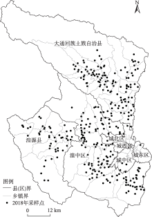
图1
采样点分布"

表1
西宁市耕地质量评价指标及权重"
| 目标层 | 准则层 | 指标层 | 指标权重 | 组合权重 |
|---|---|---|---|---|
| 质量评价 | 土壤管理 | 灌溉能力 | 0.1261 | 0.1748 |
| 排水能力 | 0.0487 | |||
| 立地条件 | 地形部位 | 0.1096 | 0.2429 | |
| 海拔 | 0.0980 | |||
| 农田林网化程度 | 0.0353 | |||
| 土壤养分 | 有机质 | 0.0745 | 0.1769 | |
| 速效钾 | 0.0489 | |||
| 有效磷 | 0.0535 | |||
| 理化性状 | 耕层质地 | 0.0698 | 0.1723 | |
| 土壤容重 | 0.0527 | |||
| pH | 0.0498 | |||
| 剖面性状 | 有效土层厚度 | 0.0569 | 0.1707 | |
| 质地构型 | 0.0668 | |||
| 障碍因 | 0.0470 | |||
| 健康状况 | 生物多样性 | 0.0361 | 0.0624 | |
| 清洁程度 | 0.0263 |
表2
西宁市耕地质量评价指标隶属函数"
| 指标名称 | 函数类型 | 函数公式 | a | c | U1 | U2 |
|---|---|---|---|---|---|---|
| pH | 峰型 | y=1/[1+a×(u-c)2] | 0.225097 | 6.685037 | 0.4 | 13.0 |
| 有机质 | 戒上型 | y=1/[1+a×(u-c)2] | 0.006107 | 27.680348 | 0.0 | 27.7 |
| 速效钾 | 戒上型 | y=1/[1+a×(u-c)2] | 0.000026 | 293.758384 | 0.0 | 294.0 |
| 有效磷 | 戒上型 | y=1/[1+a×(u-c)2] | 0.001821 | 38.076968 | 0.0 | 38.1 |
| 土壤容重 | 峰型 | y=1/[1+a×(u-c)2] | 13.854674 | 1.250789 | 0.4 | 2.1 |
| 有效土厚度 | 戒上型 | y=1/[1+a×(u-c)2] | 0.000232 | 131.349274 | 0.0 | 131.0 |
| 海拔 | 戒下型 | y=1/[1+a×(u-c)2] | 0.000001 | 649.407006 | 649.4 | 3 649.4 |
表3
西宁市耕地质量评价指标属性及其隶属度"
| 评价指标 | 指标属性(隶属度) |
|---|---|
| 地形部位 | 冲积平原(1)、河谷平原(1)、河谷阶地(0.9)、洪积平原(0.85)、黄土塬(0.8)、黄土台塬(0.7)、河漫滩(0.7)、低台地(0.7)、 黄土残塬(0.65)、低丘陵(0.65)、黄土坪(0.65)、高台地(0.65)、黄墹(0.65)、黄土梁(0.6)、高丘陵(0.6)、低山(0.5)、黄土峁(0.5)、固定沙地(0.4)、风蚀地(0.4)、中山(0.4)、半固定沙地(0.3)、流动沙地(0.2)、高山(0.2)、极高山(0.2) |
| 耕层质地 | 砂土(0.4)、砂壤(0.6)、轻壤(0.85)、中壤(1)、重壤(0.8)、黏土(0.6) |
| 生物多样性 | 丰富(1.0)、一般(0.7)、不丰富(0.4) |
| 质地构型 | 薄层型(0.4)、松散型(0.4)、紧实型(0.6)、夹层型(0.5)、上紧下松型(0.7)、上松下紧型(1.0)、海绵型(0.9) |
| 清洁程度 | 清洁(1.0)、尚清洁(0.7)、轻度污染(0.5)、中度污染(0.3)、重度污染(0.0) |
| 障碍因素 | 盐碱(0.4)、瘠薄(0.6)、酸化(0.7)、渍潜(0.5)、障碍层次(0.5)、无(1.0) |
| 灌溉能力 | 充分满足(1.0)、满足(0.7)、基本满足(0.5)、不满足(0.3) |
| 排水能力 | 充分满足(1.0)、满足(0.7)、基本满足(0.5)、不满足(0.3) |
| 农田林网化 | 高(1.0)、中(0.7)、低(0.4) |
表4
西宁市耕地质量综合指数划分标准"
| 耕地质量等级 | 耕地质量综合 指数范围 | 耕地质量等级 | 耕地质量综合 指数范围 |
|---|---|---|---|
| 一 | ≥0.904 | 六 | 0.714~0.752 |
| 二 | 0.866~0.904 | 七 | 0.676~0.714 |
| 三 | 0.828~0.866 | 八 | 0.638~0.676 |
| 四 | 0.790~0.828 | 九 | 0.600~0.638 |
| 五 | 0.752~0.790 | 十 | <0.600 |
表5
西宁市耕地质量等级面积变化"
| 分级标准 | 耕地质量等级 | 面积/hm2 | |
|---|---|---|---|
| 2015年 | 2018年 | ||
| 高等 | 一 | 0.00 | 0.00 |
| 二 | 134.57 | 54.21 | |
| 三 | 6102.55 | 10363.94 | |
| 中等 | 四 | 14746.86 | 17656.44 |
| 五 | 22296.27 | 25717.17 | |
| 六 | 14417.43 | 6055.24 | |
| 低等 | 七 | 18027.17 | 37932.66 |
| 八 | 49893.95 | 38376.37 | |
| 九 | 16448.76 | 8550.54 | |
| 十 | 2640.23 | 1.22 | |
| 总计 | 144707.79 | 144707.79 | |
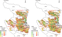
图2
2015年和2018年西宁市耕地质量等级空间分布"

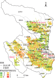
图3
西宁市耕地质量等级变化分布"

表6
西宁市耕地质量等级变化面积分布"
| 等级变化 | 面积/hm2 | 占比/% | 面积/hm2 | ||||||
|---|---|---|---|---|---|---|---|---|---|
| 城北区 | 城东区 | 城西区 | 城中区 | 大通县 | 湟源县 | 湟中区 | |||
| 3 | 3.21 | 0.002 | - | - | - | 3.21 | - | - | - |
| 2 | 6507.06 | 4.497 | 14.32 | 24.86 | - | 34.79 | 273.07 | 1986.46 | 4173.56 |
| 1 | 56560.41 | 39.086 | 138.94 | 185.93 | 53.63 | 633.36 | 17338.94 | 10968.45 | 27241.16 |
| 0 | 71172.99 | 49.184 | 1700.43 | 28.69 | 529.41 | 1262.36 | 29478.63 | 7723.80 | 30449.67 |
| -1 | 10427.24 | 7.206 | 388.82 | - | 40.78 | 7.25 | 7228.46 | 44.91 | 2717.02 |
| -2 | 36.88 | 0.025 | 6.50 | - | - | - | 30.38 | - | - |
| 总计 | 144707.79 | 100.000 | 2249.01 | 239.48 | 623.82 | 1940.97 | 54349.48 | 20723.62 | 64581.41 |
表7
西宁市不同耕地质量等级土壤主要养分分布特征"
| 年份 | 分级标准 | 质量等级 | 有机质 | 有效磷 | 速效钾 | |||||
|---|---|---|---|---|---|---|---|---|---|---|
| 含量/g·kg-1 | 评价等级 | 含量/mg·kg-1 | 评价等级 | 含量/mg·kg-1 | 评价等级 | |||||
| 2015 | 高等 | 二 | 23.02 | 1 | 108.52 | 1 | 300.99 | 1 | ||
| 三 | 19.86 | 2 | 55.73 | 1 | 239.67 | 2 | ||||
| 中等 | 四 | 19.80 | 2 | 34.07 | 2 | 210.97 | 2 | |||
| 五 | 22.04 | 1 | 20.87 | 3 | 196.06 | 3 | ||||
| 六 | 20.47 | 1 | 18.64 | 3 | 175.82 | 3 | ||||
| 低等 | 七 | 23.14 | 1 | 22.00 | 3 | 190.79 | 3 | |||
| 八 | 20.52 | 1 | 19.68 | 3 | 186.80 | 3 | ||||
| 九 | 18.16 | 2 | 14.85 | 4 | 150.88 | 3 | ||||
| 十 | 15.48 | 2 | 12.45 | 4 | 134.47 | 4 | ||||
| 2018 | 高等 | 二 | 24.43 | 1 | 64.46 | 1 | 243.95 | 2 | ||
| 三 | 23.60 | 1 | 25.55 | 2 | 197.92 | 3 | ||||
| 中等 | 四 | 23.15 | 1 | 24.78 | 3 | 200.90 | 2 | |||
| 五 | 24.93 | 1 | 25.82 | 2 | 185.21 | 3 | ||||
| 六 | 22.67 | 1 | 24.36 | 3 | 183.88 | 3 | ||||
| 低等 | 七 | 24.31 | 1 | 27.54 | 2 | 193.78 | 3 | |||
| 八 | 23.51 | 1 | 24.30 | 3 | 184.00 | 3 | ||||
| 九 | 22.13 | 1 | 19.93 | 3 | 166.20 | 3 | ||||
| 十 | 13.92 | 3 | 12.38 | 4 | 139.81 | 4 | ||||
表8
西宁市不同耕地质量等级验证信息对照"
| 分级标准 | 质量等级 | 县(区) | 实验室分析项目 | 实地调查项目 | |||||||||
|---|---|---|---|---|---|---|---|---|---|---|---|---|---|
| 有机质 /g·kg-1 | 有效磷 /mg·kg-1 | 速效钾 /mg·kg-1 | pH | 质地构型 | 耕层 质地 | 有效土层 厚度/cm | 灌溉条件 | 海拔/m | 地形部位 | ||||
| 高等 | 二 | 湟中区 | 26.30 | 31.70 | 193.00 | 8.1 | 上松下紧型 | 中壤 | 128 | 充分满足 | 2169 | 河谷阶地 | |
| 三 | 大通县 | 24.80 | 40.00 | 142.00 | 8.2 | 上松下紧型 | 中壤 | 122 | 充分满足 | 2481 | 河谷阶地 | ||
| 中等 | 四 | 城东区 | 20.40 | 24.60 | 211.00 | 8.2 | 上松下紧型 | 黏土 | 134 | 充分满足 | 2219 | 河谷阶地 | |
| 五 | 城北区 | 20.80 | 27.90 | 236.00 | 8.3 | 上松下紧型 | 中壤 | 144 | 满足 | 2409 | 河谷阶地 | ||
| 六 | 大通县 | 15.40 | 26.10 | 145.00 | 8.3 | 上松下紧型 | 重壤 | 127 | 满足 | 2424 | 河谷阶地 | ||
| 低等 | 七 | 城西区 | 23.60 | 19.10 | 192.00 | 8.2 | 上松下紧型 | 黏土 | 138 | 不满足 | 2562 | 中山 | |
| 八 | 城中区 | 25.80 | 21.50 | 198.00 | 8.3 | 上松下紧型 | 黏土 | 130 | 不满足 | 2567 | 中山 | ||
| 九 | 湟源县 | 25.30 | 22.80 | 170.00 | 8.4 | 海绵型 | 砂壤 | 117 | 不满足 | 3228 | 高山 | ||
| 十 | 湟中区 | 18.90 | 16.50 | 148.00 | 8.4 | 上松下紧型 | 黏土 | 141 | 不满足 | 2568 | 中山 | ||
| [1] | 鲁明星, 贺立源, 吴礼树. 我国耕地地力评价研究进展[J]. 生态环境, 2006, 15(4): 866-871. |
| [Lu Mingxing, He Liyuan, Wu Lishu. Fertility evaluation of cultivated land in China: A review[J]. Ecology and Environmen, 2006, 15(4): 866-871. ] | |
| [2] | 陈印军, 向雁, 金轲. 论耕地质量红线[J]. 中国农业资源与区划, 2019, 40(3): 1-4. |
| [Chen Yinjun, Xiang Yan, Jin Ke. On arable land quality red line[J]. Chinese Journal of Agricultural Resources and Regional Planning, 2019, 40(3): 1-4. ] | |
| [3] |
Li F P, Liu W, Lu Z B, et al. A multi-criteria evaluation system for arable land resource assessment[J]. Environmental Monitoring and Assessment, 2020, 192(2): 79, doi: 10.1007/s10661-019-8023-x.
doi: 10.1007/s10661-019-8023-x pmid: 31897735 |
| [4] | 李秀军, 田春杰, 徐尚起, 等. 我国农田生态环境质量现状及发展对策[J]. 土壤与作物, 2018, 7(3): 267-275. |
| [Li Xiujun, Tian Chunjie, Xu Shangqi, et al. Current situation of ecological environment quality and countermeasures in China’s farmland[J]. Soil and Crop, 2018, 7(3): 267-275. ] | |
| [5] | 杨文杰, 巩前文. 城乡融合视域下农村绿色发展的科学内涵与基本路径[J]. 农业现代化研究, 2021, 42(1): 18-29. |
| [Yang Wenjie, Gong Qianwen. The scientific connotation and the basic path of rural green development from the perspective of urban-rural integration[J]. Research of Agricultural Modernization, 2021, 42(1): 18-29. ] | |
| [6] | 文森. 重庆市耕地资源安全与预警研究[D]. 重庆: 西南大学, 2008. |
| [Wen Sen. Study on cultivated land security and early warning: A case study of Chongqing City[D]. Chongqing: Southwest University, 2008. ] | |
| [7] |
李效顺, 曲福田, 谭荣, 等. 中国耕地资源变化与保护研究——基于土地督察视角的考察[J]. 自然资源学报, 2009, 24(3): 387-401.
doi: 10.11849/zrzyxb.2009.03.003 |
|
[Li Xiaoshun, Qu Futian, Tan Rong, et al. Research on the variations and protection of the cropland in China[J]. Journal of Natural Resurous, 2009, 24(3): 387-401. ]
doi: 10.11849/zrzyxb.2009.03.003 |
|
| [8] | 姚东恒, 裴久渤, 汪景宽. 东北典型黑土区耕地质量时空变化研究[J]. 中国生态农业学报(中英文), 2020, 28(1): 104-114. |
| [Yao Dongheng, Pei Jiubo, Wang Jingkuan. Temporal-spatial changes in cultivated land quality in a black soil region of northeast China[J]. Chinese Journal of Eco-Agriculture, 2020, 28(1): 104-114. ] | |
| [9] | 康钦俊. 黄土高原区土壤养分空间变异及其耕地质量评价[D]. 咸阳: 西北农林科技大学, 2019. |
| [Kang Qinjun. Spatial variability of soil nutrients in the Loess Plateau region and evaluation of its arable land quality[D]. Xianyang: Northwest A & F University, 2019. ] | |
| [10] | 戴文举, 王东杰, 卢瑛, 等. 华南地区县域耕地质量和产能评价研究——以广东吴川为例[J]. 农业资源与环境学报, 2019, 36(4): 419-430. |
| [Dai Wenju, Wang Dongjie, Lu Ying, et al. Evaluation of county level cultivated land quality and productivity in south China: A case study of Wuchuan City, Guangdong Province[J]. Journal of Agricultural Resources and Environment, 2019, 36(4): 419-430. ] | |
| [11] | 王昊煜, 高培超, 谢一茹, 等. 基于改进型NSGA-Ⅱ算法的西宁市土地利用多目标优化[J]. 地理与地理信息科学, 2020, 36(6): 84-89. |
| [Wang Haoyu, Gao Peichao, Xie Yiru, et al. Multi-objective optimization of land use in Xining City based on improved NSGA-Ⅱ[J]. Geography and Geo-information Science, 2020, 36(6): 84-89. ] | |
| [12] | 司慧娟, 袁春, 曹银贵, 等. 青海省耕地利用变化区域差异及管理对策研究[J]. 水土保持研究, 2013, 20(6): 321-325. |
| [Si Huijuan, Yuan Chun, Cao Yingui, et al. Research on regional differences of cultivated land changes and countermeasures in Qinghai Province[J]. Research of Soil and Water Conservation, 2013, 20(6): 321-325. ] | |
| [13] |
Li Q X, Jia Z Q, Zhu Y S, et al. Spatial heterogeneity of soil nutrients after the establishment of Caragana intermedia plantation on sand dunes in alpine sandy land of the Tibet Plateau[J]. PLoS One, 2015, 10(5): e124456, doi: 10.1371/journal.pone.0124456.
doi: 10.1371/journal.pone.0124456 |
| [14] | Roger A, Libohova Z, Sinaj S, et al. Spatial variability of soil phosphorus in the Fribourg Canton, Switzerland[J]. Geoderma, 2014, 217-218: 26-36. |
| [15] | 周岩. 基于局域空间自相关的吉林省耕地质量空间分布分析[J]. 安徽农业科学, 2017, 45(32): 200-203, 208. |
| [Zhou Yan. Spatial distribution of cropland quality in Jilin Province based on local spatial auto-correlation[J]. Journal of Anhui Agricultural Sciences, 2017, 45(32): 200-203, 208. ] | |
| [16] | 向丽, 周伟, 任君, 等. 基于DPSIRM模型的高原城市湿地生态安全评价——以湟水流域西宁段为例[J]. 生态学杂志, 2022, 41(10): 2064-2071. |
| [Xiang Li, Zhou Wei, Ren Jun, et al. Ecological security evaluation of plateau urban wetland based on DPSIRM model: With Xining section of Huangshui Basin as an example[J]. Chinese Journal of Ecology, 2022, 41(10): 2064-2071. ] | |
| [17] | 李子杰, 高沪宁, 丁琪洵, 等. 基于Moran’s I的安徽省太湖县耕地质量时空格局分析[J]. 水土保持通报, 2021, 41(3): 350-356. |
| [Li Zijie, Gao Huning, Ding Qixun, et al. Analysis on temporal and spatial patterns of cultivated land quality based on Moran’s I in Taihu County, Anhui Province[J]. Bulletin of Soil and Water Conservation, 2021, 41(3): 350-356. ] | |
| [18] | 汪甜甜, 费坤, 江文娟, 等. 宣州区耕地质量等级评价及灌排能力对耕地质量影响[J]. 灌溉排水学报, 2021, 40(11): 79-89. |
| [Wang Tiantian, Fei Kun, Jiang Wenjuan, et al. Soil quality classification and the impact of irrigation and drainage in the region of Xuanzhou in Anhui Province[J]. Journal of Irrigation and Drainage, 2021, 40(11): 79-89. ] | |
| [19] | 侯淑涛, 邸延顺, 程光大, 等. 黑龙江明水县耕地质量综合评价[J]. 水土保持研究, 2015, 22(4): 232-236, 240. |
| [Hou Shutao, Di Yanshun, Cheng Guangda, et al. Comprehensive evaluation of cultivated land quality in Mingshui County, Heilongjiang Province[J]. Research of Soil and Water Conservation, 2015, 22(4): 232-236, 240. ] | |
| [20] | 张兴嘉, 蔡立群, 董博. 基于县域耕地资源管理信息系统的土壤综合肥力评价[J]. 水土保持研究, 2012, 19(4): 138-141. |
| [Zhang Xingjia, Cai Liqun, Dong Bo. The comprehensive soil fertility evaluation based on the arable land resources management information system of a county[J]. Research of Soil and Water Conservation, 2012, 19(4): 138-141. ] | |
| [21] | 张鸿辉, 刘友兆, 曾永年, 等. 基于GIS的耕地质量预警系统设计与实现[J]. 计算机应用研究, 2008, 25(10): 3174-3176, 3180. |
| [Zhang Honghui, Liu Youzhao, Zeng Yongnian, et al. Design and implementation of cultivated land quality early-warning system based on GIS[J]. Application Research of Computers, 2008, 25(10): 3174-3176, 3180. ] | |
| [22] | 赵彦锋, 程道全, 陈杰, 等. 耕地地力评价指标体系构建中的问题与分析逻辑[J]. 土壤学报, 2015, 52(6): 1197-1208. |
| [Zhao Yanfeng, Cheng Daoquan, Chen Jie, et al. Problems and analytical logic in building cultivated land productivity evaluation index system[J]. Acta Pedologica Sinica, 2015, 52(6): 1197-1208. ] | |
| [23] | 赵小娟, 叶云, 周晋皓, 等. 珠三角丘陵区耕地质量综合评价及指标权重敏感性分析[J]. 农业工程学报, 2017, 33(8): 226-235. |
| [Zhao Xiaojuan, Ye Yun, Zhou Jinhao, et al. Comprehensive evaluation of cultivated land quality and sensitivity analysis of index weight in hilly region of Pearl River Delta[J]. Transactions of the Chinese Society of Agricultural Engineering, 2017, 33(8): 226-235. ] | |
| [24] | 吕宁, 吕新, 张泽, 等. 基于GIS的绿洲农田土壤养分现状及地力评价研究[J]. 干旱地区农业研究, 2012, 30(2): 8-13. |
| [Lü Ning, Lü Xin, Zhang Ze, et al. Research on soil nutrient status and soil fertility evaluation based on GIS[J]. Agricultural Research in the Arid Areas, 2012, 30(2): 8-13. ] | |
| [25] | 高涵, 陈伟强, 郧文聚, 等. 东北典型平原区耕地健康产能评价与验证——以吉林省大安市为例[J]. 土壤通报, 2020, 51(4): 784-794. |
| [Gao Han, Chen Weiqiang, Yun Wenju, et al. Evaluation and verification of healthy productivity of cultivated land in the typical plain area of northeast China: A case study of Da’an City, Jilin Province[J]. Chinese Journal of Soil Science, 2020, 51(4): 784-794. ] | |
| [26] | 谢叶伟, 赵军, 李勇, 等. 基于GIS的典型黑土区海伦市耕地地力评价研究[J]. 干旱区地理, 2011, 34(2): 325-330. |
| [Xie Yewei, Zhao Jun, Li Yong, et al. Assessment of cropland productivity based on GIS for typical black soil region at Hailun County[J]. Arid Land Geography, 2011, 34(2): 325-330. ] | |
| [27] | 孙妍芳, 裴久渤, 张立江, 等. 辽宁棕壤耕地质量评价及障碍因素类型分区研究[J]. 中国农业资源与区划, 2017, 38(11): 130-137, 144. |
| [Sun Yanfang, Pei Jiubo, Zhang Lijiang, et al. Assessment of cultivated land quality and obstacle factors zoning of brown earth: A case study of Liaoning Province[J]. Chinese Journal of Agricultural Resources and Regional Planning, 2017, 38(11): 130-137, 144. ] | |
| [28] | 陈初红, 邹忠, 周鹤. 耕地地力评价因子权重及隶属度的确定[J]. 现代农业科技, 2011(12): 280-281. |
| [Chen Chuhong, Zou Zhong, Zhou He. Determination of weighting and membership of farmland evaluation factors[J]. Modern Agricultural Science and Technology, 2011(12): 280-281. ] | |
| [29] | 马倩倩, 董博, 许旺旺, 等. 干旱区耕地质量等级评价及土壤养分与盐渍化的分析研究——以民勤绿洲为例[J]. 干旱区地理, 2021, 44(2): 514-524. |
| [Ma Qianqian, Dong Bo, Xu Wangwang, et al. Evaluation of the quality level of arable land in arid areas and the analysis of soil nutrients and salinization: A case study of Minqin Oasis[J]. Arid Land Geography, 2021, 44(2): 514-524. ] | |
| [30] | 李双异, 刘慧屿, 白伟, 等. 耕地地力演变及其与种植业结构关系分析[J]. 土壤通报, 2016, 47(6): 1300-1305. |
| [Li Shuangyi, Liu Huiyu, Bai Wei, et al. Evolution of cultivated land productivity and its relationship with planting structure[J]. Chinese Journal of Soil Science, 2016, 47(6): 1300-1305. ] | |
| [31] | 郁洁, 高晖, 李文西, 等. 基于GIS的江苏省耕地质量等级评价[J]. 中国土壤与肥料, 2022(3): 222-230. |
| [Yu Jie, Gao Hui, Li Wenxi, et al. Evaluation of cultivated land quality in Jiangsu Province based on GIS[J]. Soils and Fertilizers Sciences in China, 2022(3): 222-230. ] | |
| [32] | 李小刚, 马友华, 张益, 等. 基于模糊评价与BP神经网络模型的耕地质量评价对比研究——以淮北平原凤台县为例[J]. 土壤通报, 2015, 46(4): 816-822. |
| [Li Xiaogang, Ma Youhua, Zhang Yi, et al. Comparison of fuzzy evaluation and BP neural network applied for cultivated land quality evaluation: A case study at Fengtai County[J]. Chinese Journal of Soil Science, 2015, 46(4): 816-822. ] | |
| [33] | 郑梦蕾, 丁世伟, 李子杰, 等. 耕地质量监测与评价研究进展[J]. 环境监测管理与技术, 2021, 33(3): 9-14. |
| [Zheng Menglei, Ding Shiwei, Li Zijie, et al. Research progress of cultivated land quality monitoring and evaluation[J]. The Administration and Technique of Environmental Monitoring, 2021, 33(3): 9-14. ] | |
| [34] | 初侨, 燕艳华, 翟明普, 等. 现代农业全产业链标准体系发展路径与对策研究[J]. 中国工程科学, 2021, 23(3): 8-15. |
| [Chu Qiao, Yan Yanhua, Zhai Mingpu, et al. Whole industrial chain standards system of modern agriculture: Development path and countermeasures[J]. Strategic Study of CAE, 2021, 23(3): 8-15. ] | |
| [35] | 杨子生. 基于可持续发展的山区省份耕地总量动态平衡研究——以云南省为例[J]. 资源科学, 2001, 23(5): 33-40. |
| [Yang Zisheng. A study on the dynamic balance of total cultivated land amount in the province of mountain region on the basis of sustainable development: Taking Yunnan Province as an example[J]. Resources Science, 2001, 23(5): 33-40. ] | |
| [36] |
Yin Q Y, Duan Z S, Li X, et al. Cultivated land quality analysis of Karst mountain areas based on GIS: A case study of Jingxi County[J]. Hunan Agricultural Science & Technology Newsletter: HASTN, 2014, 15(8): 1407, doi: 10.16175/j.cnki.1009-4229.2014.08.089.
doi: 10.16175/j.cnki.1009-4229.2014.08.089 |
| [37] | 祖健, 郝晋珉, 陈丽, 等. 耕地数量、质量、生态三位一体保护内涵及路径探析[J]. 中国农业大学学报, 2018, 23(7): 84-95. |
| [Zu Jian, Hao Jinmin, Chen Li, et al. Analysis on trinity connotation and approach to protect quantity, quality and ecology of cultivated land[J]. Journal of China Agricultural University, 2018, 23(7): 84-95. ] | |
| [38] | 康甜甜. 基于灰靶模型的宜兴市耕地质量评价[D]. 南京: 南京农业大学, 2016. |
| [Kang Tiantian. Evaluation of arable land quality in Yixing City based on grey target model[D]. Nanjing: Nanjing Agricultural University, 2016. ] |
| [1] | 江岳坤, 石鹏娟. 中国市域城乡收入差距时空演化及影响因素[J]. 干旱区地理, 2024, 47(1): 147-157. |
| [2] | 黄鑫, 焦黎, 马晓飞, 王勇辉, 阿尔曼·阿布拉. 基于RClimDex模型的近60 a中亚极端降水事件变化特征[J]. 干旱区地理, 2023, 46(7): 1039-1051. |
| [3] | 周海涛, 马钰松, 樊亚宇, 宁小莉. 内蒙古红色旅游资源空间分布及可达性分析[J]. 干旱区地理, 2023, 46(5): 814-822. |
| [4] | 丁华,廖文强,段丰浩,杨望暾. 陕西省丹霞地貌景观特征、空间分布与形成机理初探[J]. 干旱区地理, 2023, 46(4): 527-538. |
| [5] | 芦雄英, 刘贤德, 马瑞, 赵维俊, 敬文茂, 何晓玲, 赵长兴. 祁连山排露沟流域青海云杉林更新特征对地形因子的响应[J]. 干旱区地理, 2023, 46(4): 604-613. |
| [6] | 闫新杰, 孙慧, 辛龙. 新疆资源型企业的空间分布与区位选择[J]. 干旱区地理, 2023, 46(4): 678-687. |
| [7] | 姜璐,刘艳娟,史晓楠,丁博文鹏,陈虹宇. 基于物质流的青海高原城镇社区家庭能源消费研究——以西宁市为例[J]. 干旱区地理, 2023, 46(2): 294-304. |
| [8] | 马晓敏, 张志斌, 郭倩倩, 吴志祥, 冯雪丽. 中国科普教育基地空间分布、类型结构及影响因素[J]. 干旱区地理, 2023, 46(11): 1879-1890. |
| [9] | 刘尊方, 雷浩川, 盛海彦. 基于XGBoost模型的湟水流域耕地土壤养分遥感反演[J]. 干旱区地理, 2023, 46(10): 1643-1653. |
| [10] | 赵志远,丁逸尘,杨喜平,吴升. 基于手机定位数据的西宁市老年人公园绿地可达性预测[J]. 干旱区地理, 2023, 46(10): 1744-1756. |
| [11] | 谢聪慧,吴世新,林娟,庄庆威,张子慧,侯冠宇,罗格平. 基于PSO-PNN模型的喀什噶尔绿洲耕地盐渍化分析[J]. 干旱区地理, 2022, 45(5): 1547-1558. |
| [12] | 张仲福. 黄河流域甘肃段地质遗迹空间区划及可持续开发利用策略[J]. 干旱区地理, 2022, 45(4): 1235-1243. |
| [13] | 李冀宁,刘晚莹. 宁夏地区汉代丝绸之路沿线村落遗址空间分布及其影响因素分析[J]. 干旱区地理, 2022, 45(4): 1291-1301. |
| [14] | 龙小翠,刘京,徐仲炜,尉芳. 陕西渭北旱塬区县域耕地时空变化及其对粮食生产影响[J]. 干旱区地理, 2022, 45(2): 423-434. |
| [15] | 卢卓瑜,崔建新,张晓虹,李鹏. 清至民国毛乌素沙地佟哈拉克泊复原及演变研究[J]. 干旱区地理, 2021, 44(4): 1083-1092. |
|
||