干旱区地理 ›› 2025, Vol. 48 ›› Issue (6): 995-1005.doi: 10.12118/j.issn.1000-6060.2024.412 cstr: 32274.14.ALG2024412
苗颖凤( ), 原野(), 周正伟, 赵嘉瑜, 郭宇茜
收稿日期:2024-07-10
修回日期:2024-12-10
出版日期:2025-06-25
发布日期:2025-06-18
通讯作者:
原野(1989-),男,博士,副教授,主要从事土地资源利用与评价等方面的研究. E-mail: yuanye2452@163.com作者简介:苗颖凤(1999-),女,硕士研究生,主要从事土地资源利用与评价等方面的研究. E-mail: 18834849136@163.com
基金资助:
MIAO Yingfeng(), YUAN Ye(), ZHOU Zhengwei, ZHAO Jiayu, GUO Yuxi
Received:2024-07-10
Revised:2024-12-10
Published:2025-06-25
Online:2025-06-18
摘要: 粮食安全是国家发展和社会稳定的基础,探究农作物种植结构的时空演变可为保障区域粮食安全、促进区域农业可持续发展提供理论依据。选取汾渭平原117个县(市/区)为研究对象,以2000—2022年农业统计数据为数据源,运用标准差椭圆模型、空间自相关等方法,探讨2000—2022年汾渭平原县域主要农作物种植结构的时空演变规律。结果表明:(1) 2000—2022年汾渭平原共出现了88种农作物种植结构类型,其中,小麦和玉米及其组合类型是汾渭平原主要的农作物种植结构类型。从时空分布来看,小麦型的县域数目逐渐减少,玉米型县域数目逐年增加,小麦玉米型县域逐渐由汾渭平原西南地区向东北地区扩散;而玉米小麦型在汾渭平原各地均呈零散分布的格局。从类型丰富度来看,2005年农作物种植结构类型最丰富,而2015年丰富度指数最小。(2) 2000—2022年汾渭平原小麦、玉米和蔬菜种植格局均呈现沿东北—西南方向分布的格局,小麦重心基本保持稳定,玉米重心不断向东北方向偏移,蔬菜重心由合阳县向西南方向偏移到澄城县。总之,汾渭平原主要农作物空间分布呈现差异化发展态势,小麦种植面积呈现缩减态势,而玉米和蔬菜则呈现扩张态势,未来宜在研判农作物种植结构时空发展态势的基础上,从保障粮食安全的视角加强对汾渭平原农作物种植结构的宏观调控。
苗颖凤, 原野, 周正伟, 赵嘉瑜, 郭宇茜. 汾渭平原农作物种植结构时空格局演变特征研究[J]. 干旱区地理, 2025, 48(6): 995-1005.
MIAO Yingfeng, YUAN Ye, ZHOU Zhengwei, ZHAO Jiayu, GUO Yuxi. Spatio-temporal pattern evolution characteristics of crop planting structure on Fenwei Plain[J]. Arid Land Geography, 2025, 48(6): 995-1005.
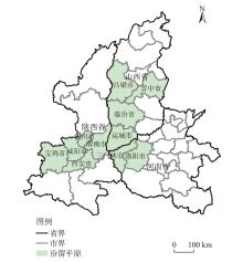
图1
汾渭平原地理位置示意图 注:基于自然资源部标准地图服务网站审图号为GS(2023)2767号的标准地图制作,底图边界无修改。下同。"
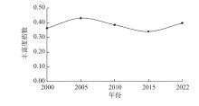
图2
2000—2022年汾渭平原农作物种植结构丰富度指数"
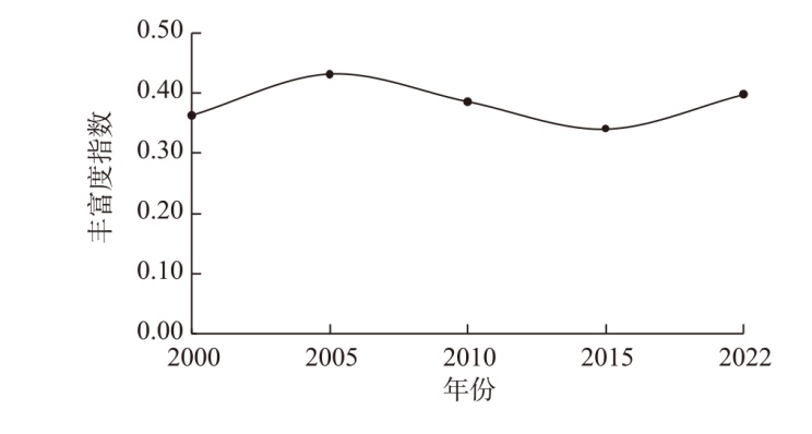
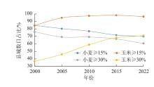
图3
汾渭平原小麦和玉米种植比例≥15%和≥30%的县域数目占比"

表1
2000—2022年汾渭平原主要农作物种植结构类型的数量及比例"
| 排序 | 2000年 | 2005年 | 2010年 | ||||||||
|---|---|---|---|---|---|---|---|---|---|---|---|
| 类型 | 县数/个 | 比例/% | 类型 | 县数/个 | 比例/% | 类型 | 县数/个 | 比例/% | |||
| 1 | 小麦~玉米型 | 33 | 28.21 | 小麦~玉米型 | 27 | 23.08 | 小麦玉米型 | 33 | 28.21 | ||
| 2 | 小麦玉米型 | 19 | 16.24 | 小麦玉米型 | 23 | 19.66 | 小麦~玉米型 | 21 | 17.95 | ||
| 3 | 小麦~玉米其他型 | 10 | 8.55 | 小麦~玉米其他型 | 10 | 8.55 | 玉米型 | 15 | 12.82 | ||
| 4 | 小麦型 | 9 | 7.69 | 玉米型 | 6 | 5.13 | 小麦~玉米其他型 | 8 | 6.84 | ||
| 5 | 玉米~小麦型 | 5 | 4.27 | 玉米小麦型 | 5 | 4.27 | 小麦玉米~蔬菜型 | 5 | 4.27 | ||
| 排序 | 2015年 | 2022年 | |||||||||
| 类型 | 县数/个 | 比例/% | 类型 | 县数/个 | 比例/% | ||||||
| 1 | 小麦玉米型 | 34 | 29.06 | 小麦玉米型 | 29 | 24.79 | |||||
| 2 | 小麦~玉米型 | 18 | 15.38 | 玉米型 | 15 | 12.82 | |||||
| 3 | 玉米型 | 17 | 14.53 | 小麦~玉米型 | 15 | 12.82 | |||||
| 4 | 小麦玉米~蔬菜型 | 7 | 5.98 | 小麦玉米~蔬菜型 | 9 | 7.69 | |||||
| 5 | 玉米小麦型 | 7 | 5.98 | 玉米~小麦型 | 5 | 4.27 | |||||
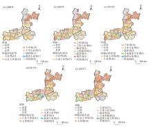
图4
2000—2022年汾渭平原主要农作物种植结构类型时空变化 注:括号内数值为主要农作物种植结构类型(种植比例≥30%的作物及其组合)的县域数目。"

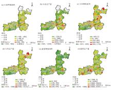
图5
汾渭平原县域尺度小麦、玉米和蔬菜种植面积和总产量的变化趋势 注:*表示变化趋势显著(P<0.05)。"

表2
2000—2022年汾渭平原小麦、玉米和蔬菜种植面积和总产量的全局Moran’s I指数"
| 作物 | 要素 | 2000年 | 2005年 | 2010年 | 2015年 | 2022年 |
|---|---|---|---|---|---|---|
| 小麦 | 种植面积 | 0.42 | 0.42 | 0.44 | 0.44 | 0.40 |
| 总产量 | 0.43 | 0.41 | 0.39 | 0.39 | 0.37 | |
| 玉米 | 种植面积 | 0.27 | 0.27 | 0.25 | 0.21 | 0.24 |
| 总产量 | 0.35 | 0.35 | 0.32 | 0.36 | 0.29 | |
| 蔬菜 | 种植面积 | 0.21 | 0.22 | 0.26 | 0.30 | 0.36 |
| 总产量 | 0.28 | 0.26 | 0.20 | 0.26 | 0.36 |
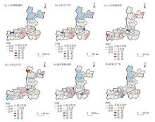
图6
2022年汾渭平原小麦、玉米和蔬菜种植面积和总产量的局部空间自相关类型"

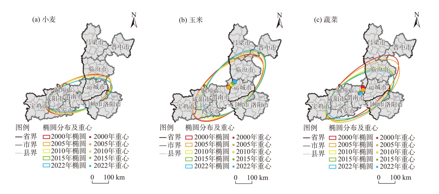
图7
2000—2022年汾渭平原小麦、玉米和蔬菜种植面积的标准差椭圆分布"
| [1] |
张旭辉, 玉素甫江·如素力, 仇忠丽, 等. 基于Sentinel-2时序数据的新疆焉耆盆地农作物遥感识别与评估[J]. 干旱区地理, 2024, 47(4): 672-683.
doi: 10.12118/j.issn.1000-6060.2023.262 |
| [Zhang Xuhui, Rusuli Yusufujiang, Qiu Zhongli, et al. Remote sensing identification and evaluation of crops in Yanqi Basin, Xinjiang, China based on Sentinel-2 time series data[J]. Arid Land Geography, 2024, 47(4): 672-683. ] | |
| [2] | Ren D, Yang Y, Hu Y, et al. Evaluating the potentials of cropping adjustment for groundwater conservation and food production in the piedmont region of the North China Plain[J]. Stochastic Environmental Research and Risk Assessment, 2019, 35(1): 1-12. |
| [3] |
安悦, 谭雪兰, 谭杰扬, 等. 湖南省农作物种植结构演变及影响因素[J]. 经济地理, 2021, 41(2): 156-166.
doi: 10.15957/j.cnki.jjdl.2021.02.017 |
|
[An Yue, Tan Xuelan, Tan Jieyang, et al. Evolution of crop planting structure in traditional agricultural areas and its influence factors: A case study in Hunan Province[J]. Economic Geography, 2021, 41(2): 156-166. ]
doi: 10.15957/j.cnki.jjdl.2021.02.017 |
|
| [4] | 管仁华. 粮食安全视角下的农业产业结构调整与优化策略[J]. 农村科学实验, 2024(17): 89-91. |
| [Guan Renhua. Agricultural industry structure adjustment and optimization strategies from the perspective of food security[J]. Rural Science Experiment, 2024(17): 89-91. ] | |
| [5] |
朱磊, 王科, 丁一民, 等. 基于Sentinel-2的青铜峡灌区水稻和玉米种植分布早期识别[J]. 干旱区地理, 2024, 47(5): 850-860.
doi: 10.12118/j.issn.1000-6060.2023.541 |
|
[Zhu Lei, Wang Ke, Ding Yimin, et al. Early identification of rice and corn planting distribution in Qingtongxia irrigation area based on Sentinel-2[J]. Arid Land Geography, 2024, 47(5): 850-860. ]
doi: 10.12118/j.issn.1000-6060.2023.541 |
|
| [6] | Guo W, Huang Y M, Huang Y D, et al. Develop agricultural planting structure prediction model based on machine learning: The aging of the population has prompted a shift in the planting structure toward food crops[J]. Computers and Electronics in Agriculture, 2024, 221: 108941, doi: 10.1016/j.compag.2024.108941. |
| [7] | Chen X G, Huang Q Z, Xiong Y W, et al. Tracking the spatio-temporal change of the main food crop planting structure in the Yellow River Basin over 2001—2020[J]. Computers and Electronics in Agriculture, 2023, 212: 108102, doi: 10.1016/j.compag.2023.108102. |
| [8] | 孙斌, 毕春宁, 薛建春, 等. 基于时序Sentinel-2影像的引黄灌区作物结构提取和供需水分析[J]. 人民黄河, 2024, 46(7): 131-137. |
| [Sun Bin, Bi Chunning, Xue Jianchun, et al. Extraction of crop structure and analysis of water supply and demand in irrigation area of Yellow River diversion based on Sentinel-2 image[J]. Yellow River, 2024, 46(7): 131-137. ] | |
| [9] |
黄玛兰, 李晓云. 农业劳动力价格上涨对农作物种植结构变化的省际差异性影响[J]. 经济地理, 2019, 39(6): 172-182.
doi: 10.15957/j.cnki.jjdl.2019.06.019 |
|
[Huang Malan, Li Xiaoyun. The impacts of rural labor price rising on crop structure among provinces[J]. Economic Geography, 2019, 39(6): 172-182. ]
doi: 10.15957/j.cnki.jjdl.2019.06.019 |
|
| [10] | Ding N, Tao F L, Chen Y. Effects of climate change, crop planting structure, and agricultural management on runoff, sediment, nitrogen and phosphorus losses in the Hai-River Basin since the 1980s[J]. Journal of Cleaner Production, 2022, 359: 132066, doi: 10.1016/j.jclepro.2022.132066. |
| [11] |
张莉, 吴文斌, 杨鹏, 等. 黑龙江省宾县农作物格局时空变化特征分析[J]. 中国农业科学, 2013, 46(15): 3227-3237.
doi: 10.3864/j.issn.0578-1752.2013.15.018 |
|
[Zhang Li, Wu Wenbin, Yang Peng, et al. Temporal and spatial changes in crop patterns of Binxian County in Heilongjiang Province[J]. Scientia Agricultura Sinica, 2013, 46(15): 3227-3237. ]
doi: 10.3864/j.issn.0578-1752.2013.15.018 |
|
| [12] | 胡韵菲, 刘序, 梁俊芬, 等. 粤港澳大湾区1990—2020年农作物种植结构时空演变[J]. 广东农业科学, 2023, 50(1): 13-27. |
| [Hu Yunfei, Liu Xu, Liang Junfen, et al. Spatial and temporal evolution of crop planting structure in Guangdong-Hong Kong-Macao Greater Bay Area from 1990 to 2020[J]. Guangdong Agricultural Sciences, 2023, 50(1): 13-27. ] | |
| [13] |
任频频, 李保国, 黄峰. 农作物种植结构演变下的黄淮海旱作区小麦玉米生产时空格局[J]. 资源科学, 2022, 44(3): 436-449.
doi: 10.18402/resci.2022.03.02 |
| [Ren Pinpin, Li Baoguo, Huang Feng. Spatiotemporal patterns of wheat and maize production under the evolution of crop planting structures in the Huang-Huai-Hai dry farmland, China[J]. Resource Science, 2022, 44(3): 436-449. ] | |
| [14] | 杜国明, 张扬, 李全峰. 21世纪以来三江平原农作物种植结构演化研究[J]. 农业现代化研究, 2019, 40(5): 736-744. |
| [Du Guoming, Zhang Yang, Li Quanfeng. The evolution path of crop structure in the Sanjiang Plain in the 21st century[J]. Research of Agricultural Modernization, 2019, 40(5): 736-744. ] | |
| [15] | 杜蓉, 柳思维, 蔡荣. 中国粮食空间生产格局演变特征及其驱动机制[J]. 经济问题, 2023(8): 92-102. |
| [Du Rong, Liu Siwei, Cai Rong. The characteristics and driving mechanisms of China’s grain spatial production pattern evolution[J]. Economic Issues, 2023(8): 92-102. ] | |
| [16] |
张荣天, 张贇. 江苏省农作物种植结构时空格局演变探析[J]. 中国稻米, 2023, 29(2): 48-52.
doi: 10.3969/j.issn.1006-8082.2023.02.010 |
|
[Zhang Rongtian, Zhang Yun. Analysis of the temporal and spatial pattern evolution of crop planting structure in Jiangsu Province[J]. China Rice, 2023, 29(2): 48-52. ]
doi: 10.3969/j.issn.1006-8082.2023.02.010 |
|
| [17] | 王帅. 辽宁省农作物种植面积的变化特征分析[J]. 农业科技与装备, 2024(5): 89-91. |
| [Wang Shuai. Analysis on the change characteristics of crop planting area in Liaoning Province[J]. Agricultural Science & Technology and Equipment, 2024(5): 89-91. ] | |
| [18] |
刘珍环, 杨鹏, 吴文斌, 等. 近30年中国农作物种植结构时空变化分析[J]. 地理学报, 2016, 71(5): 840-851.
doi: 10.11821/dlxb201605012 |
|
[Liu Zhenhuan, Yang Peng, Wu Wenbin, et al. Spatio-temporal changes in Chinese crop patterns over the past three decades[J]. Acta Geographica Sinica, 2016, 71(5): 840-851. ]
doi: 10.11821/dlxb201605012 |
|
| [19] | 杨宗辉, 李金锴, 韩晨雪, 等. 我国粮食生产重心变迁及其影响因素研究[J]. 农业现代化研究, 2019, 40(1): 36-43. |
| [Yang Zonghui, Li Jinkai, Han Chenxue, et al. The evolution path of China’s grain production base and the influencing factors[J]. Research of Agricultural Modernization, 2019, 40(1): 36-43. ] | |
| [20] |
王利民, 刘佳, 季富华, 等. 中国小麦面积种植结构时空动态变化分析[J]. 中国农学通报, 2019, 35(18): 12-23.
doi: 10.11924/j.issn.1000-6850.casb18120121 |
|
[Wang Limin, Liu Jia, Ji Fuhua, et al. Analysis of spatial-temporal dynamic change of wheat planting structure of China[J]. Chinese Agricultural Science Bulletin, 2019, 35(18): 12-23. ]
doi: 10.11924/j.issn.1000-6850.casb18120121 |
|
| [21] | 邹军, 朱颖璇, 杨雨豪, 等. 1981—2015年华北地区种植结构演变及其驱动机制分析[J]. 中国农业大学学报, 2019, 24(12): 23-32. |
| [Zou Jun, Zhu Yingxuan, Yang Yuhao, et al. Analysis of planting structure evolution and its driving mechanism in north China from 1981 to 2015[J]. Journal of China Agricultural University, 2019, 24(12): 23-32. ] | |
| [22] |
屠爽爽, 简代飞, 龙花楼, 等. 广西主要农作物生产格局演变特征与机制研究[J]. 地理学报, 2022, 77(9): 2322-2337.
doi: 10.11821/dlxb202209013 |
|
[Tu Shuangshuang, Jian Daifei, Long Hualou, et al. Evolution characteristics and mechanisms of major crops production patterns in Guangxi[J]. Acta Geographica Sinica, 2022, 77(9): 2322-2337. ]
doi: 10.11821/dlxb202209013 |
|
| [23] |
闫梦川, 魏东岚, 吴云霞. 东北三省主要粮食作物种植结构时空演变分析[J]. 北方农业学报, 2020, 48(6): 114-118.
doi: 10.12190/j.issn.2096-1197.2020.06.19 |
|
[Yan Mengchuan, Wei Donglan, Wu Yunxia. Analysis on the spatio-temporal evolution of the main food crops planting structure in the three northeastern provinces[J]. Journal of Northern Agriculture, 2020, 48(6): 114-118. ]
doi: 10.12190/j.issn.2096-1197.2020.06.19 |
|
| [24] | 党文硕, 张玉翠, 成功, 等. 冀北高原农业种植结构的演变[J]. 中国生态农业学报(中英文), 2024, 32(9): 1441-1450. |
| [Dang Wenshuo, Zhang Yucui, Cheng Gong, et al. Evolution of agricultural planting structure in the northern Hebei Plateau[J]. Chinese Journal of Ecological Agriculture, 2024, 32(9): 1441-1450. ] | |
| [25] | 黄丽排, 张建兵, 陆双龙, 等. 广西农作物种植结构时空格局及其驱动因子分析[J]. 西南农业学报, 2021, 34(8): 1682-1689. |
| [Huang Lipai, Zhang Jianbing, Lu Shuanglong, et al. Spatio-temporal pattern and driving factors of crop planting structure in Guangxi[J]. Southwest China Journal of Agricultural Sciences, 2021, 34(8): 1682-1689. ] | |
| [26] | 吴芳, 潘志芬, 李涛, 等. 西藏县域农作物种植结构时空变化及专业化分区[J]. 应用与环境生物学报, 2022, 28(4): 935-944. |
| [Wu Fang, Pan Zhifen, Li Tao, et al. Spatial evolution and specialization division of crop planting structure in counties of Tibet, China[J]. China Journal of Applied and Environmental Biology, 2022, 28(4): 935-944. ] | |
| [27] | 刘冬, 余侃华, 师小燕, 等. 陕西省种植业结构变化及时空演变分析[J]. 中国农业资源与区划, 2021, 42(9): 251-261. |
| [Liu Dong, Yu Kanhua, Shi Xiaoyan, et al. Analysis of structural changes and spatial-temporal evolution of planting industry in Shaanxi[J]. Chinese Journal of Agricultural Resources and Regional Planning, 2021, 42(9): 251-261. ] | |
| [28] | 王泓淯, 房艳刚, 刘建志. 2005—2015年黑龙江省农作物种植结构时空演变[J]. 地域研究与开发, 2020, 39(1): 168-174. |
| [Wang Hongyu, Fang Yangang, Liu Jianzhi. Spatio-temporal changes of crop structure in Heilongjiang Province from 2005 to 2015[J]. Areal Research and Development, 2020, 39(1): 168-174. ] | |
| [29] | 赵秦怡, 王昱之. 基于GIS的滩区型农村居民点格局演变——以黄河中游汾渭平原为例[J]. 科技和产业, 2024, 24(21): 247-253. |
| [Zhao Qinyi, Wang Yuzhi. Evolution of rural settlement of Russia patterns based on GIS: A case study of the Fenwei Plain in the middle reaches of the Yellow River[J]. Science Technology and Industry, 2024, 24(21): 247-253. ] | |
| [30] | 黄小刚, 邵天杰, 赵景波, 等. 汾渭平原PM2.5浓度的影响因素及空间溢出效应[J]. 中国环境科学, 2019, 39(8): 3539-3548. |
| [Huang Xiaogang, Shao Tianjie, Zhao Jingbo, et al. Influence factors and spillover effect of PM2.5concentration on Fen-wei Plain[J]. China Environmental Science, 2019, 39(8): 3539-3548. ] | |
| [31] |
蒋凌霄, 安悦, 谭雪兰, 等. 近30年来长株潭地区农作物种植结构演变及优化对策[J]. 经济地理, 2020, 40(1): 173-180.
doi: 10.15957/j.cnki.jjdl.2020.01.019 |
|
[Jiang Lingxiao, An Yue, Tan Xuelan, et al. Temporal and spatial evolution and optimized countermeasure of crop planting structure in the Changsha-Zhuzhou-Xiangtan area in recent 30 years[J]. Economic Geography, 2020, 40(1): 173-180. ]
doi: 10.15957/j.cnki.jjdl.2020.01.019 |
|
| [32] |
罗前程, 王月甜, 迟文峰, 等. 内蒙古黑土区农作物种植结构演化影响因素[J]. 资源科学, 2023, 45(5): 994-1005.
doi: 10.18402/resci.2023.05.09 |
| [Luo Qiancheng, Wang Yuetian, Chi Wenfeng, et al. Influencing factors of crop planting structure change in the black soil region of Inner Mongolia[J]. Resource Science, 2023, 45(5): 994-1005. ] | |
| [33] |
颉佳, 王世金, 窦文康, 等. 1989—2019年中国滑雪场时空特征及其演变规律[J]. 地理科学, 2022, 42(6): 1064-1072.
doi: 10.13249/j.cnki.sgs.2022.06.012 |
|
[Xie Jia, Wang Shijin, Dou Wenkang, et al. The spatio-temporal characteristics and evolution law of Chinese ski resorts from 1989 to 2019[J]. Scientia Geographica Sinica, 2022, 42(6): 1064-1072. ]
doi: 10.13249/j.cnki.sgs.2022.06.012 |
|
| [34] | Tobler W. A computer movie simulating urban growth in the Detroit region[J]. Economic Geography, 1970, 46: 234-240. |
| [35] | Kumari M, Sarma K, Sharma R. Using Moran’s I and GIS to study the spatial pattern of land surface temperature in relation to land use/cover around a thermal power plant in Singrauli district, Madhya Pradesh, India[J]. Remote Sensing Applications: Society and Environment, 2019, 15: 100239, doi: 10.1016/j.rsase.2019.100239. |
| [1] | 马晓敏, 张志斌, 郭倩倩, 赵学伟, 张宁. 2000—2020年兰州市人口时空格局演变及驱动因素分析[J]. 干旱区地理, 2025, 48(1): 168-178. |
| [2] | 周镕基, 骆丽庄, 吴思斌. 中国新世纪水稻生产负外部性评估及时空演变研究[J]. 干旱区地理, 2024, 47(5): 830-840. |
| [3] | 卢冬燕, 朱秀芳, 唐明秀, 郭春华, 刘婷婷. 不同温升情景下中国旱灾风险变化评估[J]. 干旱区地理, 2024, 47(3): 369-379. |
| [4] | 张明斗, 任衍婷, 周亮. 黄河流域城市生态韧性时空演变特征及影响因素分析[J]. 干旱区地理, 2024, 47(3): 445-454. |
| [5] | 高亚苗, 陈浩楠, 王芳, 南雄雄, 陈红翔, 李文慧. 宁夏典型粮食作物生产水足迹时空演变及节水潜力评价[J]. 干旱区地理, 2024, 47(12): 2005-2016. |
| [6] | 任洪杰, 李辉尚. 中国乡村生态韧性时空演变特征及影响因素探究[J]. 干旱区地理, 2024, 47(11): 1915-1923. |
| [7] | 任贵秀, 刘凯. 黄河流域绿色创新的时空演化特征及影响因素分析[J]. 干旱区地理, 2024, 47(1): 158-169. |
| [8] | 袁宏伟, 蔡俊, 章磊. 国家重点生态功能区人类活动与生境质量时空变化特征及空间效应[J]. 干旱区地理, 2023, 46(6): 934-948. |
| [9] | 马丽娜, 张飞云, 翟玉鑫, 滕伦, 康建国. 1980—2020年新疆土地利用变化下生态系统服务价值时空演变分析[J]. 干旱区地理, 2023, 46(2): 253-263. |
| [10] | 窦睿音, 张文洁, 陈晨. 陕西省“三生”空间格局演变与驱动机制研究[J]. 干旱区地理, 2023, 46(2): 264-273. |
| [11] | 倪红红, 马强, 卜元坤, 杨小轩, 李卫忠. 陕西省林业企业时空格局演变及影响因素分析[J]. 干旱区地理, 2023, 46(12): 2098-2110. |
| [12] | 翟玉鑫, 张飞云, 马丽娜. 基于三生空间的博斯腾湖流域生境质量时空演变及预估[J]. 干旱区地理, 2023, 46(11): 1792-1802. |
| [13] | 姜萍, 胡列群, 许婷婷. 近60 a新疆大气水分亏缺的时空变化特征[J]. 干旱区地理, 2023, 46(1): 1-10. |
| [14] | 程静,王鹏,陈红翔,韩永贵. 半干旱区生态风险时空演变及其影响因素的地理探测——以宁夏盐池县为例[J]. 干旱区地理, 2022, 45(5): 1637-1648. |
| [15] | 韩艳莉,于德永,陈克龙,杨海镇. 2000—2018年青海湖流域气温和降水量变化趋势空间分布特征[J]. 干旱区地理, 2022, 45(4): 999-1009. |
|
||