干旱区地理 ›› 2025, Vol. 48 ›› Issue (6): 1006-1019.doi: 10.12118/j.issn.1000-6060.2024.460 cstr: 32274.14.ALG2024460
米瑞华( ), 倪世龙, 刘书敏
收稿日期:2024-07-30
修回日期:2024-10-12
出版日期:2025-06-25
发布日期:2025-06-18
作者简介:米瑞华(1983-),女,博士,副教授,主要从事人口经济学、空间人口学研究. E-mail: rice221@163.com
基金资助:
MI Ruihua(), NI Shilong, LIU Shumin
Received:2024-07-30
Revised:2024-10-12
Published:2025-06-25
Online:2025-06-18
摘要: 高精度农业人口空间分布研究是构建现代农业产业体系的基础性工作,对培育农业新质生产力具有重要决策价值。基于第七次中国人口普查分县数据与中国土地利用遥感监测数据集(分辨率1 km),探索了农业人口格网化方法,实现了1 km格网尺度的中国农业人口密度可视化表达,验证指标显示数据结果具有良好的精度。结果表明:(1) 中国农业人口沿胡焕庸线具有显著分异特征,东南半壁农业人口格网密度均值(30.57人·km-2)是西北半壁(1.92人·km-2)的15.9倍。(2) 农业人口分布沿地势三级阶梯下降而梯度递增,密度分别为0.98人·km-2、11.27 人·km-2和30.76人·km-2。(3) 各个农业区的地形与气候对农业人口分布影响较大,温暖湿润的低海拔农业区农业人口密集,高寒干旱的高原丘陵农业区农业人口相对稀疏。研究建议实施差异化的数字农业推进策略,重点加强黄淮平原区等农业人口密集地区的农业数字化转型,促进生态脆弱区的特色农旅融合,加快培育新型职业农民。
米瑞华, 倪世龙, 刘书敏. 基于土地利用的中国农业人口格网分布特征分析[J]. 干旱区地理, 2025, 48(6): 1006-1019.
MI Ruihua, NI Shilong, LIU Shumin. Analysis of grid distribution characteristics of agricultural population in China based on land use data[J]. Arid Land Geography, 2025, 48(6): 1006-1019.
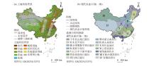
图1
研究区示意图"

表1
土地利用类型的权重"
| 土地利用类型 | 地类 代码 | 编号 (j) | 权重(fj ) | ||
|---|---|---|---|---|---|
| 方案1 | 方案2 | 方案3 | |||
| 水田 | 11 | 1 | 20.00 | 12.00 | 10.00 |
| 旱地 | 12 | 2 | 7.00 | 5.00 | 4.00 |
| 林地 | 20 | 3 | 3.00 | 2.20 | 2.00 |
| 草地 | 30 | 4 | 3.00 | 3.50 | 1.90 |
| 水域 | 40 | 5 | 0.45 | 0.80 | 0.09 |
| 城镇用地 | 51 | 6 | 3.00 | 3.00 | 5.00 |
| 农村居民点 | 52 | 7 | 3.50 | 3.00 | 5.00 |
| 其他建设用地 | 53 | 8 | 60.00 | 70.00 | 72.00 |
| 未利用土地 | 60 | 9 | 0.05 | 0.50 | 0.01 |
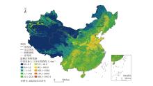
图2
中国农业人口1 km格网密度分布"

表2
胡焕庸线两侧农业人口分布情况"
| 胡焕庸线两侧 | 国土面积占比/% | 水田占比/% | 旱地占比/% | 农业人口 | ||
|---|---|---|---|---|---|---|
| 占比/% | 密度/人·km-2 | 人均耕地面积/hm2 | ||||
| 东南半壁 | 42.65 | 98.14 | 77.86 | 92.22 | 30.57 | 1.18 |
| 西北半壁 | 57.35 | 1.86 | 22.14 | 7.78 | 1.92 | 2.86 |
| 合计 | 100.00 | 100.00 | 100.00 | 100.00 | - | - |
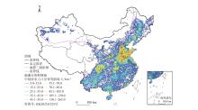
图3
中国农业人口密度等值线"
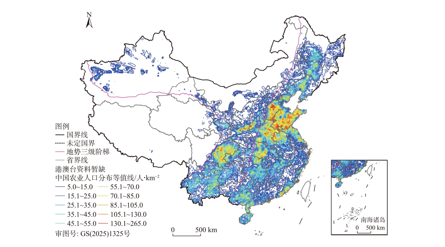
表3
地势三级阶梯的农业人口分布情况"
| 地势三级阶梯 | 国土面积占比/% | 水田占比/% | 旱地占比/% | 农业人口 | ||
|---|---|---|---|---|---|---|
| 占比/% | 密度/人·km-2 | 人均耕地面积/hm2 | ||||
| 第一级阶梯 | 27.71 | 0.20 | 2.35 | 1.92 | 0.98 | 1.23 |
| 第二级阶梯 | 43.13 | 22.55 | 42.59 | 34.47 | 11.27 | 1.43 |
| 第三级阶梯 | 29.16 | 77.25 | 55.06 | 63.61 | 30.76 | 1.25 |
| 合计 | 100.00 | 100.00 | 100.00 | 100.00 | - | - |
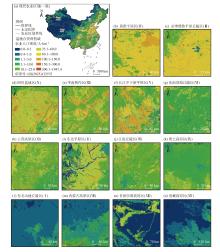
图4
中国各农业区的农业人口1 km格网分布"

表4
中国各个农业区上的农业人口分布情况"
| 区划编号 | 现代农业区划 | 国土面积 占比/% | 水田 占比/% | 旱地 占比/% | 农业人口 | ||
|---|---|---|---|---|---|---|---|
| 占比/% | 密度/人·km-2 | 人均耕地面积/hm2 | |||||
| Ⅳ | 黄淮平原区 | 2.97 | 7.47 | 11.98 | 13.97 | 66.52 | 1.02 |
| Ⅲ | 京津冀鲁平原丘陵区 | 3.41 | 0.54 | 12.70 | 12.87 | 53.39 | 0.98 |
| Ⅹ | 四川盆地区 | 3.63 | 12.50 | 7.69 | 9.19 | 35.85 | 1.27 |
| Ⅻ | 华南热作区 | 3.55 | 6.80 | 3.78 | 7.99 | 31.94 | 0.75 |
| Ⅴ | 长江中下游平原区 | 4.38 | 29.13 | 3.27 | 9.88 | 31.89 | 1.30 |
| Ⅵ | 东南沿海丘陵区 | 1.68 | 5.30 | 0.73 | 3.30 | 28.21 | 0.75 |
| Ⅺ | 云贵高原区 | 5.87 | 7.87 | 6.58 | 10.54 | 25.37 | 0.86 |
| Ⅱ | 东北平原区 | 5.01 | 7.11 | 15.34 | 8.73 | 24.66 | 1.99 |
| Ⅶ | 江南丘陵区 | 5.22 | 17.07 | 2.56 | 8.55 | 23.14 | 0.95 |
| Ⅸ | 黄土高原区 | 4.88 | 0.50 | 12.37 | 7.19 | 20.84 | 1.71 |
| Ⅰ | 东北山地丘陵区 | 6.58 | 4.49 | 6.62 | 1.68 | 3.61 | 4.77 |
| Ⅷ | 内蒙古高原区 | 6.72 | 0.76 | 6.45 | 1.67 | 3.53 | 3.92 |
| ⅩⅢ | 甘新沙漠高原区 | 22.03 | 0.03 | 7.72 | 2.47 | 1.58 | 3.08 |
| ⅩⅣ | 青藏高原区 | 24.07 | 0.43 | 2.21 | 1.97 | 1.16 | 1.17 |
| 合计 | 100.00 | 100.00 | 100.00 | 100.00 | - | - | |
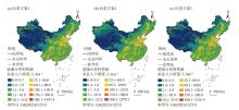
图5
权重方案的有效性验证"

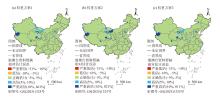
图6
不同权重方案下相对估计误差的空间分布"
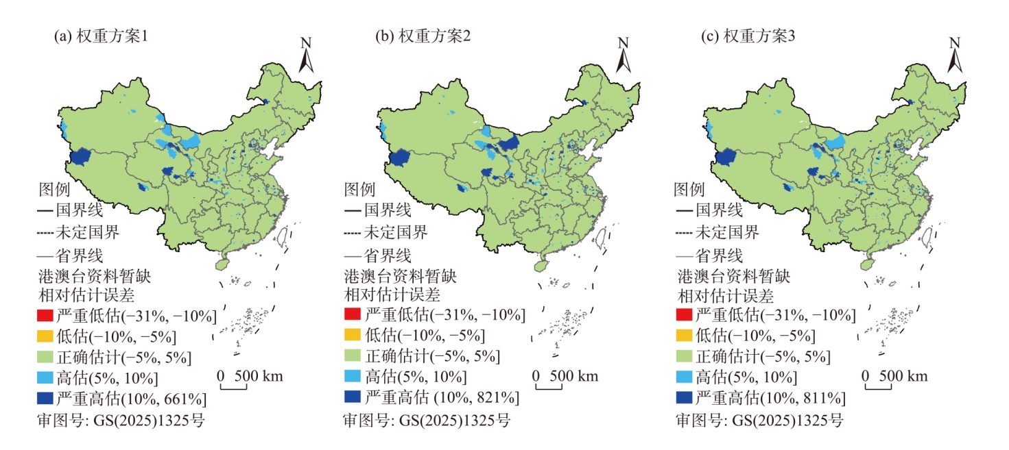
表5
不同权重方案下的精度评估"
| 权重方案 | RMSE | MAE | MAPE/% | r |
|---|---|---|---|---|
| 方案1 | 55.65 | 33.71 | 2.45 | 0.999 |
| 方案2 | 58.43 | 35.64 | 2.69 | 0.999 |
| 方案3 | 58.30 | 35.37 | 2.77 | 0.999 |
图7
格网尺度的有效性验证"
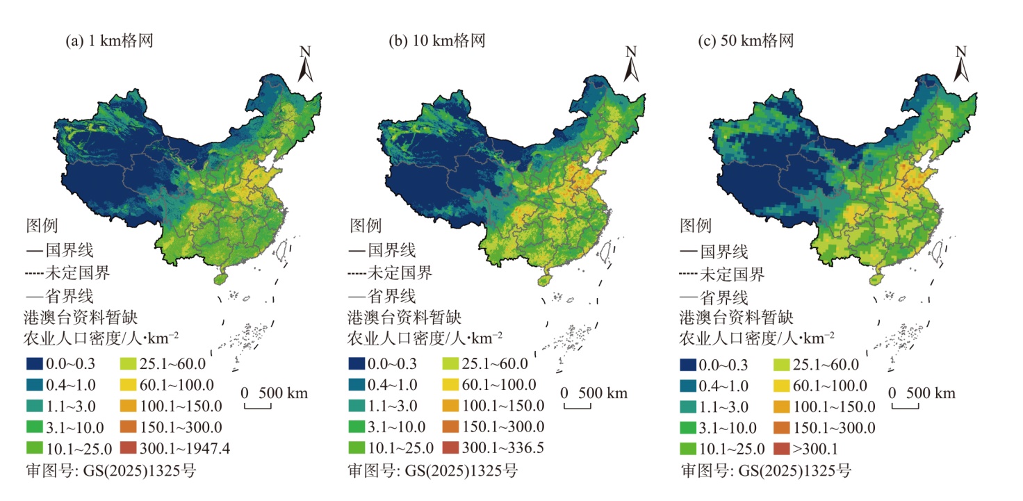
图8
不同格网尺度下相对估计误差的空间分布"

表6
不同格网尺度下的精度评估"
| 格网尺度/km | RMSE | MAE | MAPE/% | r |
|---|---|---|---|---|
| 1 | 55.65 | 33.71 | 2.45 | 0.999 |
| 10 | 413.15 | 268.23 | 21.51 | 0.997 |
| 50 | 1494.44 | 983.54 | 73.52 | 0.950 |
| [1] | 胡焕庸, 张善余. 中国人口地理(上册)[M]. 上海: 华东师范大学出版社, 1984. |
| [Hu Huanyong, Zhang Shanyu. Population geography of China (first volume)[M]. Shanghai: East China Normal University Press, 1984. ] | |
| [2] | 王克冬, 曾维忠, 武佩佩. 以新质生产力引领农业农村现代化——内在逻辑、机遇挑战与实现路径[J]. 四川农业大学学报, 2024, 42(6): 1159-1164, 1178. |
| [Wang Kedong, Zeng Weizhong, Wu Peipei. Leading agricultural and rural modernization with new quality productivity: Intrinsic logic, opportunities and challenges, implementation pathways[J]. Journal of Sichuan Agricultural University, 2024, 42(6): 1159-1164, 1178. ] | |
| [3] | 戴蓉, 郭泺, 薛达元, 等. 中国农业人口分布格局的时空变化特征[J]. 中国人口·资源与环境, 2010, 20(增刊2): 186-189. |
| [Dai Rong, Guo Luo, Xue Dayuan, et al. Spatio-temporal characteristics of agricultural population spatial distribution in China[J]. Journal of China Population, Resources and Environment, 2010, 20(Suppl. 2): 186-189. ] | |
| [4] | 陈阳. 县域尺度下农业人口分布特征及驱动因素初探——以四川省为例[C]// 中国城市规划学会, 重庆市人民政府. 活力城乡美好人居——2019中国城市规划年会论文集(18乡村规划). 北京: 中国建筑工业出版社, 2019: 11. |
| [Chen Yang. A preliminary study on the distribution characteristics and driving factors of agricultural population at the county scale: A case study of Sichuan Province[C]// China Urban Planning Society, Chongqing Municipal People’s Government. Vibrant Urban and Rural Areas, Beautiful Living:Proceedings of the 2019 China Urban Planning Annual Conference (18 Rural Planning). Beijing: China Architecture & Building Press, 2019: 11. ] | |
| [5] | 王海涛, 吴通宜, 白正兵, 等. 陕西省农业人口空间分布与时空演变特征研究[J]. 地理空间信息, 2020, 18(10): 106-109, 6. |
| [Wang Haitao, Wu Tongyi, Bai Zhengbing, et al. Research on spatial distribution and spatio-temporal evolution characteristics of agricultural population in Shaanxi Province[J]. Geospatial Information, 2020, 18(10): 106-109, 6. ] | |
| [6] | 杨燕新, 曹毅, 王文斌. 晋中市农业人口分布的分形研究[J]. 山西农业大学学报(自然科学版), 2011, 31(6): 573-576. |
| [Yang Yanxin, Cao Yi, Wang Wenbin. The fractal study of agricultural population distribution in Jinzhong City[J]. Journal of Shanxi Agricultural University (Natural Science Edition), 2011, 31(6): 573-576. ] | |
| [7] | 米瑞华, 刘书敏, 倪世龙. 陕西省农业人口格网分布特征及其时空演变[J]. 陕西师范大学学报(自然科学版), 2025, 53(2): 37-47. |
| [Mi Ruihua, Liu Shumin, Ni Shilong. Research on the grid distribution characteristics and spatiotemporal evolution of agricultural population in Shaanxi Province[J]. Journal of Shaanxi Normal University (Natural Science Edition), 2025, 53(2): 37-47. ] | |
| [8] | 张慧泽, 高启杰. 新农人现象与乡村人才振兴机制构建——基于社会与产业双重网络视角[J]. 现代经济探讨, 2021(2): 121-125. |
| [Zhang Huize, Gao Qijie. The phenomenon of new farmers and the construction of vitalizing mechanism of rural talents: Based on the perspective of social and industrial dual network[J]. Modern Economic Research, 2021(2): 121-125. ] | |
| [9] | Javanmard R, Lee J, Kim J, et al. The impacts of the modifiable areal unit problem (MAUP) on social equity analysis of public transit reliability[J]. Journal of Transport Geography, 2023, 106: 103500, doi: 10.1016/j.jtrangeo.2022.103500. |
| [10] | Mei Y, Gui Z, Wu J, et al. Population spatialization with pixel-level attribute grading by considering scale mismatch issue in regression modeling[J]. Geo-spatial Information Science, 2022, 25(3): 365-382. |
| [11] |
刘彦随, 张紫雯, 王介勇. 中国农业地域分异与现代农业区划方案[J]. 地理学报, 2018, 73(2): 203-218.
doi: 10.11821/dlxb201802001 |
|
[Liu Yansui, Zhang Ziwen, Wang Jieyong. Regional differentiation and comprehensive regionalization scheme of modern agriculture in China[J]. Acta Geographica Sinica, 2018, 73(2): 203-218. ]
doi: 10.11821/dlxb201802001 |
|
| [12] | 徐新良, 刘纪远, 张树文, 等. 中国多时期土地利用遥感监测数据集(CNLUCC)[DB/OL]. [2018]. 资源环境科学数据注册与出版系统(http://www.resdc.cn/DOI). |
| [Xu Xinliang, Liu Jiyuan, Zhang Shuwen, et al. China multi-period land use remote sensing monitoring dataset (CNLUCC)[DB/OL]. [2018]. Resource and Environmental Science Data Registration and Publication System (http://www.resdc.cn/DOI).] | |
| [13] | 蒋捷, 杨昕. 基于DEM中国地势三大阶梯定量划分[J]. 地理信息世界, 2009, 7(1): 8-13. |
| [Jiang Jie, Yang Xin. Quantitative segmentation of the three gradient terrain of China based on EDM[J]. Journal of Spatio-temporal Information, 2009, 7(1): 8-13. ] | |
| [14] | 米瑞华, 杨昕, 冯飞. 城市开发区人口分布预测及其规划价值——以西安市高新区为例[J]. 西北大学学报(自然科学版), 2019, 49(5): 801-807. |
| [Mi Ruihua, Yang Xin, Feng Fei. Population distribution projection in urban evelopment zones and its planning value: Taking Xi’an high-tech zone as an example[J]. Journal of Northwest University (Natural Science Edition), 2019, 49(5): 801-807. ] | |
| [15] | 郑川, 贾召亮, 许瑞杰, 等. 基于风险普查建筑物隐患数据和夜间灯光数据的云南省盈江县人口分布精细化研究[J]. 地震研究, 2023, 46(3): 403-414. |
| [Zheng Chuan, Jia Zhaoliang, Xu Ruijie, et al. Refinement study of population distribution in Yingjiang County based on hidden danger data and nighttime lighting data of risk census[J]. Journal of Seismological Research, 2023, 46(3): 403-414. ] | |
| [16] | 淳锦, 张新长, 黄健锋, 等. 基于POI数据的人口分布格网化方法研究[J]. 地理与地理信息科学, 2018, 34(4): 83-89, 124, 2. |
| [Chun Jin, Zhang Xinchang, Huang Jianfeng, et al. A gridding method of redistributing population based on POIs[J]. Geography and Geo-information Science, 2018, 34(4): 83-89, 124, 2. ] | |
| [17] | Yang X C, Ye T T, Zhao N Z, et al. Population mapping with multisensor remote sensing images and point-of-interest data[J]. Remote Sensing, 2019, 11(5): 574, doi: 10.3390/rs11050574. |
| [18] |
李姗姗, 林文坛. 基于夜光遥感的粤港澳大湾区人口空间分布及特征研究[J]. 热带地理, 2023, 43(3): 384-394.
doi: 10.13284/j.cnki.rddl.003640 |
|
[Li Shanshan, Lin Wentan. Spatial distribution and characteristics of population in the Guangdong-Hong Kong Macao Greater Bay Area based on night-light remote sensing[J]. Tropical Geography, 2023, 43(3): 384-394. ]
doi: 10.13284/j.cnki.rddl.003640 |
|
| [19] |
桂志鹏, 梅宇翱, 吴华意, 等. 顾及POI人口吸引力异质性的城市人口空间化方法[J]. 地球信息科学学报, 2022, 24(10): 1883-1897.
doi: 10.12082/dqxxkx.2022.220384 |
| [Gui Zhipeng, Mei Yu’ao, Wu Huayi, et al. Urban population spatialization by considering the heterogeneity on local resident attraction force of POIs[J]. Journal of Geo-information Science, 2022, 24(10): 1883-1897. ] | |
| [20] |
李慧敏, 罗大伟, 窦世卿. 利用腾讯位置大数据进行多尺度人口空间化估算[J]. 测绘通报, 2022(6): 93-97.
doi: 10.13474/j.cnki.11-2246.2022.0178. |
|
[Li Huimin, Luo Dawei, Dou Shiqing. The estimation of population on multi-spatial scale using Tencent location big data[J]. Bulletin of Surveying and Mapping, 2022(6): 93-97. ]
doi: 10.13474/j.cnki.11-2246.2022.0178. |
|
| [21] | Yu B, Lian T, Huang Y, et al. Integration of nighttime light remote sensing images and taxi GPS tracking data for population surface enhancement[J]. International Journal of Geographical Information Science, 2019, 33(4): 687-706. |
| [22] | 张学珍, 王发浩, 路伟东, 等. 1776—1953年中国传统农区人口的格网化重建[J]. 中国科学: 地球科学, 2022, 52(3): 528-539. |
| [Zhang Xuezhen, Wang Fahao, Lu Weidong, et al. Grid reconstruction of Chinese traditional agricultural area population from 1776 to 1953[J]. Scientia Sinica (Terrae), 2022, 52(3): 528-539. ] | |
| [23] | Han D R, Yang X H, Cai H Y, et al. Modelling spatial distribution of fine-scale populations based on residential properties[J]. International Journal of Remote Sensing, 2019, 40(14): 5287-5300. |
| [24] | 吴京航, 桂志鹏, 申力, 等. 顾及格网属性分级与空间关联的人口空间化方法[J]. 武汉大学学报(信息科学版), 2022, 47(9): 1364-1375. |
| [Wu Jinghang, Gui Zhipeng, Shen Li, et al. Population spatialization by considering pixel-level attribution grading and spatial association[J]. Geomatics and Information Science of Wuhan University, 2022, 47(9): 1364-1375. ] | |
| [25] | Wang F, Lu W, Zheng J, et al. Spatially explicit mapping of historical population density with random forest regression: A case study of Gansu Province, China, in 1820 and 2000[J]. Sustainability, 2020, 12(3): 1231, doi: 10.3390/su12031231. |
| [26] | Wang L Y, Fan H, Wang Y K. Fine-resolution population mapping from international space station nighttime photography and multisource social sensing data based on similarity matching[J]. Remote Sensing, 2019, 11(16): 1900, doi: 10.3390/rs11161900. |
| [27] | Ye T, Zhao N, Yang X, et al. Improved population mapping for China using remotely sensed and points-of-interest data within a random forests model[J]. Science of the Total Environment, 2019, 658: 936-946. |
| [28] | Wang L, Fan H, Wang Y. Improving population mapping using Luojia 1-01 nighttime light image and location-based social media data[J]. Science of the Total Environment, 2020, 730: 139148, doi: 10.1016/j.scitotenv.2020.139148. |
| [29] | Sinha P, Gaughan A E, Stevens F R, et al. Assessing the spatial sensitivity of a random forest model: Application in gridded population modeling[J]. Computers, Environment and Urban Systems, 2019, 75: 132-145. |
| [30] |
罗永臻, 董春, 张玉. 人口空间化适宜格网评价方法研究[J]. 地球信息科学学报, 2023, 25(5): 896-908.
doi: 10.12082/dqxxkx.2023.220536 |
| [Luo Yongzhen, Dong Chun, Zhang Yu. Study on the method of evaluating the suitable grid for population spatialization[J]. Journal of Geo-information Science, 2023, 25(5): 896-908. ] | |
| [31] |
董南, 杨小唤, 蔡红艳, 等. 人口密度格网尺度适宜性评价方法研究——以宣州区乡村区域为例[J]. 地理学报, 2017, 72(12): 2310-2324.
doi: 10.11821/dlxb201712014 |
|
[Dong Nan, Yang Xiaohuan, Cai Hongyan, et al. Suitability evaluation of gridded population distribution: A case study in rural area of Xuanzhou district, China[J]. Acta Geographica Sinica, 2017, 72(12): 2310-2324. ]
doi: 10.11821/dlxb201712014 |
|
| [32] | Fang Y, Jawitz J W. High-resolution reconstruction of the United States human population distribution, 1790 to 2010[J]. Scientific Data, 2018, 5: 180067, doi: 10.1038/sdata.2018.92. |
| [33] | 王明明, 王卷乐. 山东省街道/乡镇级格网化人口空间分布数据集(2000、2010年)[J]. 中国科学数据 2019, 4(3): 182-192. |
| [Wang Mingming, Wang Juanle. Gridded data of township-level population distribution in Shandong Province (2000 & 2010)[J]. China Scientific Data, 2019, 4(3): 182-192. ] | |
| [34] | 米瑞华, 石英. 基于常住人口分布的城市主副中心识别方法——以西安市为例[J]. 陕西师范大学学报(自然科学版), 2014, 42(3): 97-102. |
| [Mi Ruihua, Shi Ying. Identifying method of CBD and sub-CBD based on the distribution of resident population: A case study of Xi’an City[J]. Journal of Shaanxi Normal University (Natural Science Edition), 2014, 42(3): 97-102. ] | |
| [35] |
郭子翰, 陈斐, 刘晓丽, 等. 基于土地利用类型提高人口格网数据空间精度的方法[J]. 测绘通报, 2021(12): 66-70.
doi: 10.13474/j.cnki.11-2246.2021.374 |
|
[Guo Zihan, Chen Fei, Liu Xiaoli, et al. A method to improve the spatial accuracy of population grided data based on land use[J]. Bulletin of Surveying and Mapping, 2021(12): 66-70. ]
doi: 10.13474/j.cnki.11-2246.2021.374 |
|
| [36] | 周祖根, 王静龙. 人口密度的等值线图应用研究[J]. 中国人口科学, 1992(5): 28-33. |
| [Zhou Zugen, Wang Jinglong. Application research on contour map of population density[J]. Chinese Journal of Population Science, 1992(5): 28-33. ] | |
| [37] | 伍理. 介绍新编“1/(600万)”中国人口分布图和等值线密度图[J]. 人口研究, 1987(4): 59-60, 58. |
| [Wu Li. Introduction to the newly compiled “1/(6 million)” China population distribution map and contour density map[J]. Population Research, 1987(4): 59-60, 58. ] | |
| [38] | Leyk S, Gaughan A E, Adamo S B, et al. The spatial allocation of population: A review of large-scale gridded population data products and their fitness for use[J]. Earth System Science Data, 2019, 11(3): 1385-1409. |
| [39] |
肖东升, 王宁, 刘志成. 干旱地区“代表性人口格网数据集”精度研究——以甘宁青地区为例[J]. 干旱区地理, 2023, 46(3): 505-514.
doi: 10.12118/j.issn.1000-6060.2022.351 |
|
[Xiao Dongsheng, Wang Ning, Liu Zhicheng. Accuracy of “Representative population grid dataset” in arid areas: A case of Gansu-Ningxia-Qinghai region[J]. Arid Land Geography, 2023, 46(3): 505-514. ]
doi: 10.12118/j.issn.1000-6060.2022.351 |
|
| [40] | Bai Z Q, Wang J L, Wang M M, et al. Accuracy assessment of multi-source gridded population distribution datasets in China[J]. Sustainability, 2018, 10(5): 1363, doi: 10.3390/su10051363. |
| [1] | 姜筱筱, 李雪梅, 韩惠, 许民, 凌红波. 甘肃省土地利用转变对碳储量变化的影响研究[J]. 干旱区地理, 2024, 47(12): 2075-2082. |
| [2] | 马新萍, 韩申山, 王磊, 王建兴, 许晓婷. 大西安地区土地利用类型时空演变分析[J]. 干旱区地理, 2020, 43(2): 499-507. |
| [3] | 董晴晴, 占车生, 王会肖, 王飞宇, 朱明承, 牛存稳. 2000年以来的渭河流域实际蒸散发时空格局分析[J]. 干旱区地理, 2016, 39(2): 327-335. |
|
||