干旱区地理 ›› 2026, Vol. 49 ›› Issue (8): 1750-1763.doi: 10.12118/j.issn.1000-6060.2025.638 cstr: 32274.14.ALG2025638
• 城乡发展 • 上一篇
路知秋1,2( ), 律名扬1,2, 李智慧1,2, 徐丽萍1,2()
收稿日期:2025-10-18
修回日期:2025-11-04
出版日期:2026-08-25
发布日期:2026-08-21
通讯作者:
徐丽萍(1978-),女,博士,教授,主要从事景观生态学和城乡发展等方面的研究. E-mail: xlpalw@163.com作者简介:路知秋(2001-),女,硕士研究生,主要从事城乡融合发展等方面的研究. E-mail: 15090026922@163.com
基金资助:
LU Zhiqiu1,2(), LYU Mingyang1,2, LI Zhihui1,2, XU Liping1,2()
Received:2025-10-18
Revised:2025-11-04
Published:2026-08-25
Online:2026-08-21
摘要:
县域是城乡融合发展的重要切入点,也是实施乡村振兴战略、推动城乡融合发展的主战场。以新疆维吾尔自治区83个县域为研究对象,构建“人-地-业”三维指标体系,采用熵权法测度2001—2021年新疆县域城乡融合发展水平。通过核密度分析、转移矩阵探究城乡融合发展水平演变特征,并借助耦合协调度模型探索不同维度间的协调与制约关系。结果表明:(1) 2001—2021年新疆县域城乡融合各维度发展水平及综合水平均显著提升,整体呈现“北高南低”态势,但演进特征各异。“人融合”水平由“全域低水平”转为“梯度分化”的空间格局;“地融合”水平提升相对缓慢,且南北疆差距较大;“业融合”水平的县域差距缩小,较高值区空间集聚增强;南北疆的综合水平差距,呈现“先扩大、后缩小”的趋势。(2) 2001—2021年新疆县域城乡融合发展可分为3个阶段:“低速发展阶段(2001—2006年)”“过渡阶段(2006—2016年)”“快速发展阶段(2016—2021年)”。(3) 2001—2021年“人-地-业”耦合协调水平持续提升,空间上呈现“北高南低”格局。系统协调结构显著改善,具体表现为:严重失调县域实现清零,中度失调县域数量锐减,以及良好协调县域开始显现。基于此,建议精准识别薄弱地区的发展短板与滞后维度,推动资源要素定向倾斜,促进各维度协调发展;同时,培育区域性增长极,构建“以点带面、梯度推进”的城乡融合发展格局。
路知秋, 律名扬, 李智慧, 徐丽萍. “人-地-业”视角下新疆城乡融合发展的多维评价与时空演化[J]. 干旱区地理, 2026, 49(8): 1750-1763.
LU Zhiqiu, LYU Mingyang, LI Zhihui, XU Liping. Multi-dimensional evaluation and temporal evolution of urban-rural integration development in Xinjiang from the perspective of “people-land-industry”[J]. Arid Land Geography, 2026, 49(8): 1750-1763.
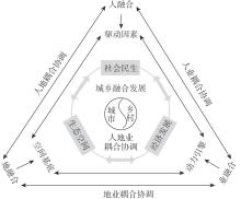
图1
系统框架"
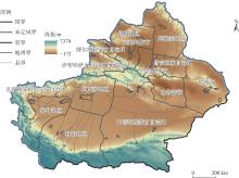
图2
研究区示意图 注:基于自然资源部标准地图服务网站审图号为GS(2023)2767号的标准地图制作,底图边界无修改。下同。"
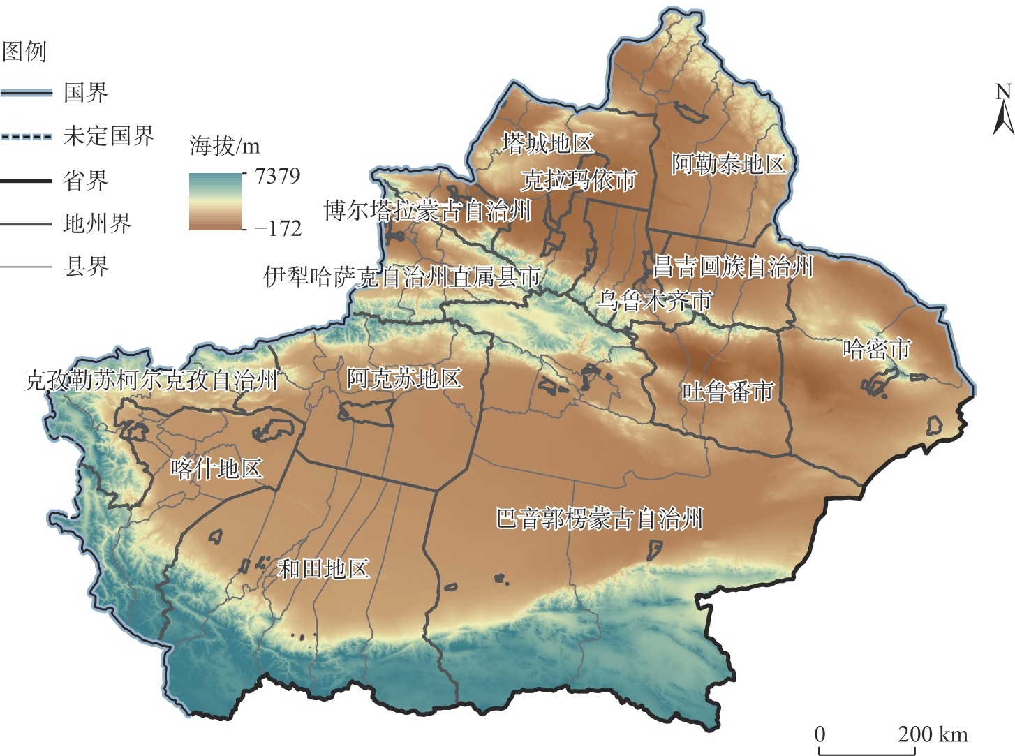

表1
数据来源"
| 数据 | 年份 | 来源以及分辨率 |
|---|---|---|
| 社会经济数据 | 2001、2006、2011、2016、2021 | 《中国县域统计年鉴》《新疆统计年鉴》、新疆维吾尔自治区国民经济和社会发展统计公报 |
| PM2.5浓度 | 2001、2006、2011、2016、2021 | 达尔豪斯大学大气成分分析组( |
| NDVI | 2001、2006、2011、2016、2021 | 中国科学院资源环境科学与数据中心( |
| 矢量行政区划数据 | 2023 | 自然资源部地图技术审查中心( |
| 路网数据 | 2021 | Open Street Map( |
| 沙漠数据 | 2000 | 国家青藏高原科学数据中心( |
| 绿洲数据 | 2020 | 干旱区生态与资源科学数据中心( |
表2
指标体系"
| 目标层 | 准则层 | 指标说明 | 单位 | 属性 | 权重/% | 参考文献 |
|---|---|---|---|---|---|---|
| 人融合 | 人口密度 | 人口数量/区域面积 | 人·km-2 | + | 13.23 | [ |
| 人口城镇化率 | 城镇人口/总人口×100% | % | + | 3.53 | [ | |
| 居民财富状况 | 人均储蓄存款余额 | 元·人-1 | + | 7.76 | [ | |
| 教育发展水平 | 义务教育阶段学生数/总人口×100% | % | + | 1.87 | [ | |
| 医疗发展水平 | 医疗、卫生院床位数 | 张·(103人)-1 | + | 2.14 | [ | |
| 社会保障水平 | 社会福利收养性单位床位 | 张·(103人)-1 | + | 6.35 | [ | |
| 地融合 | 地均粮食产量 | 粮食产量/播种面积 | kg·km-2 | + | 1.25 | [ |
| 土地城镇化率 | 建成区面积/区域面积×100% | % | + | 13.27 | [ | |
| 城市空间扩张 | 建成区面积/耕地面积×100% | % | - | 0.28 | [ | |
| 农业面源污染 | 化肥施用量/播种面积 | kg·km-2 | - | 0.55 | [ | |
| 空气质量 | PM2.5浓度 | μg·m-3 | - | 0.69 | [ | |
| NDVI | 区域NDVI均值 | 无量纲 | + | 5.13 | [ | |
| 业融合 | 人均GDP | 区域生产总值/区域人口 | 元·人-1 | + | 7.70 | [ |
| 产业结构 | (二产产值+三产产值)/一产产值 | 无量纲 | + | 9.79 | [ | |
| 农业发展水平 | 农业机械总动力/播种面积 | kW·km-2 | + | 9.64 | [ | |
| 工业发展水平 | 规模以上工业企业数 | 个 | + | 7.29 | [ | |
| 金融发展水平 | 人均年末金融机构贷款余额 | 元·人-1 | + | 9.53 | [ |
表3
耦合协调度等级"
| 取值范围 | 协调等级 | 取值范围 | 协调等级 |
|---|---|---|---|
| D≤0.2 | 严重失调 | 0.5<D≤0.6 | 勉强协调 |
| 0.2<D≤0.3 | 中度失调 | 0.6<D≤0.7 | 初级协调 |
| 0.3<D≤0.4 | 轻度失调 | 0.7<D≤0.8 | 中级协调 |
| 0.4<D≤0.5 | 濒临失调 | 0.8<D≤0.9 | 良好协调 |
图3
“人融合”水平"
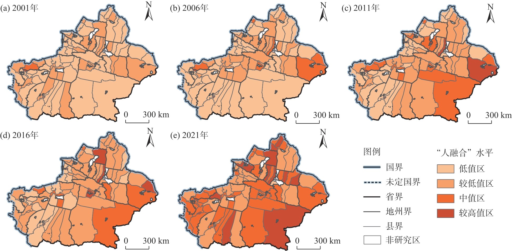
图4
“地融合”水平"
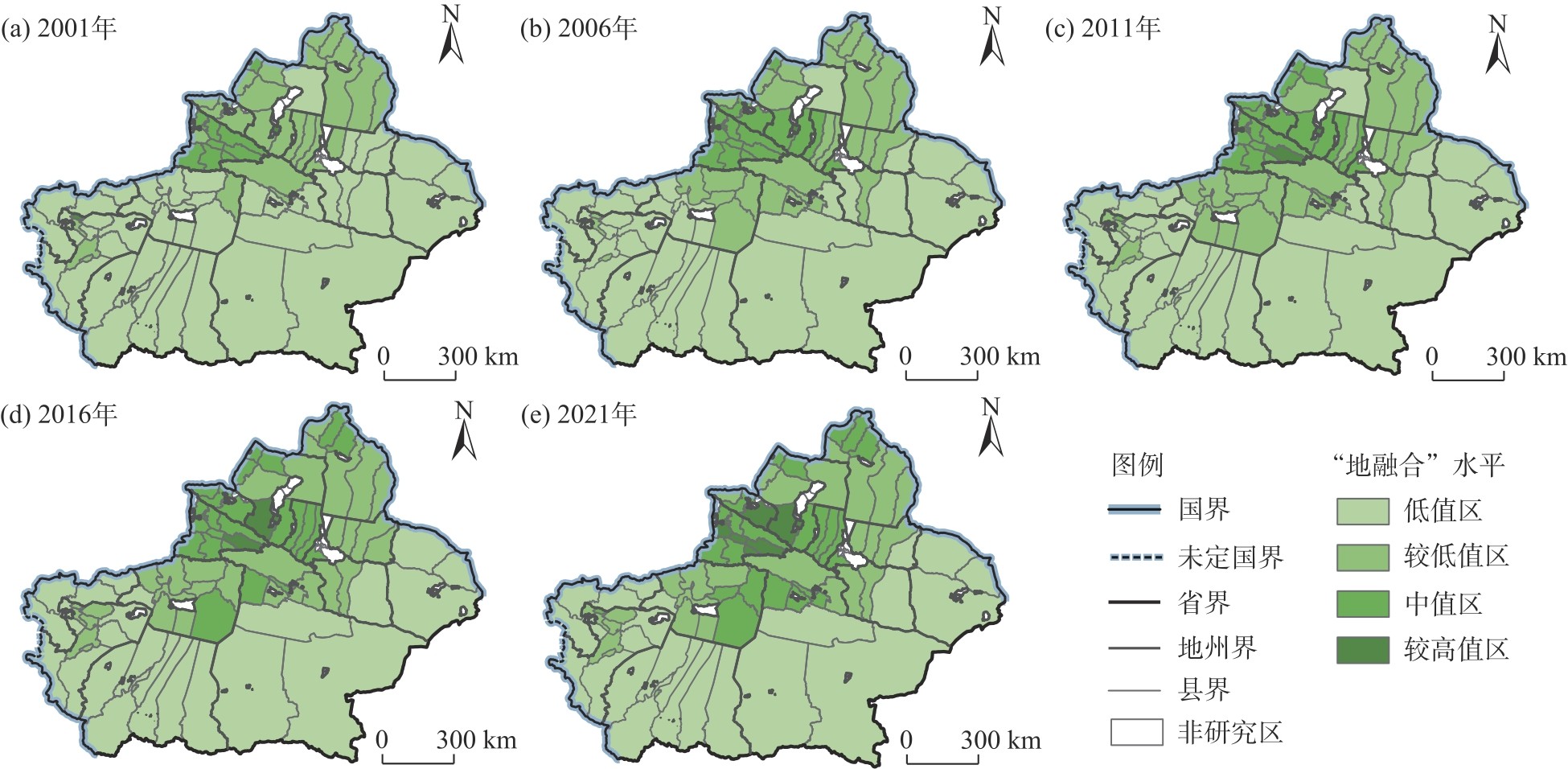
图5
“业融合”水平"
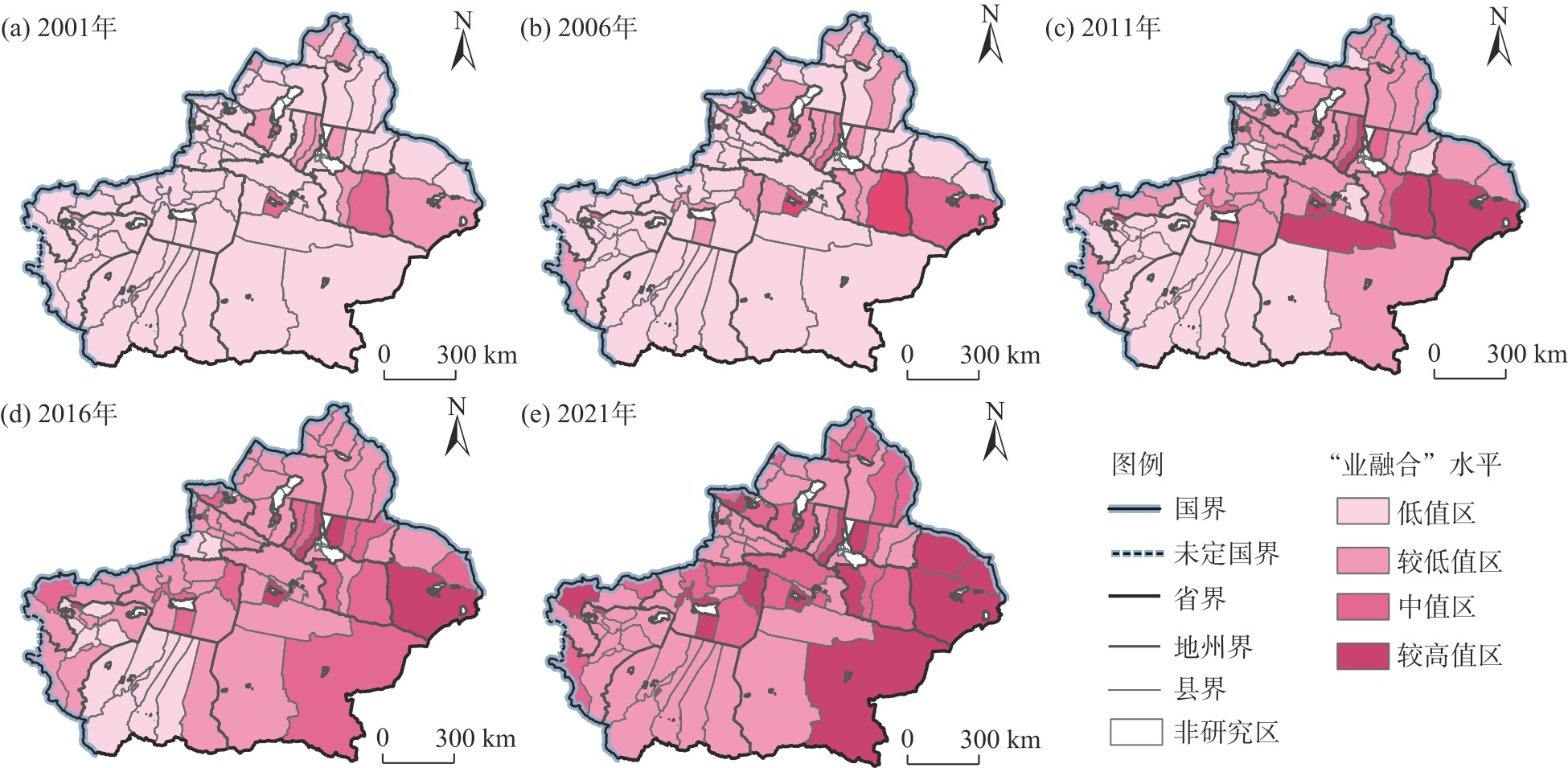
图6
城乡融合综合水平"
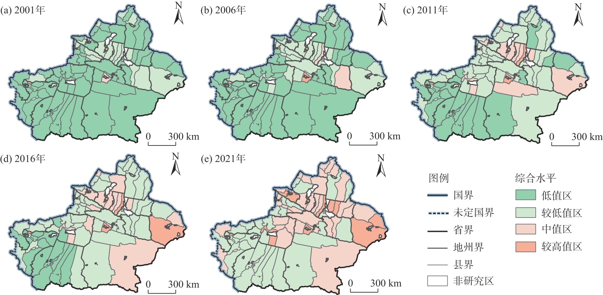
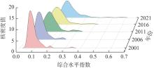
图7
综合水平核密度估计"
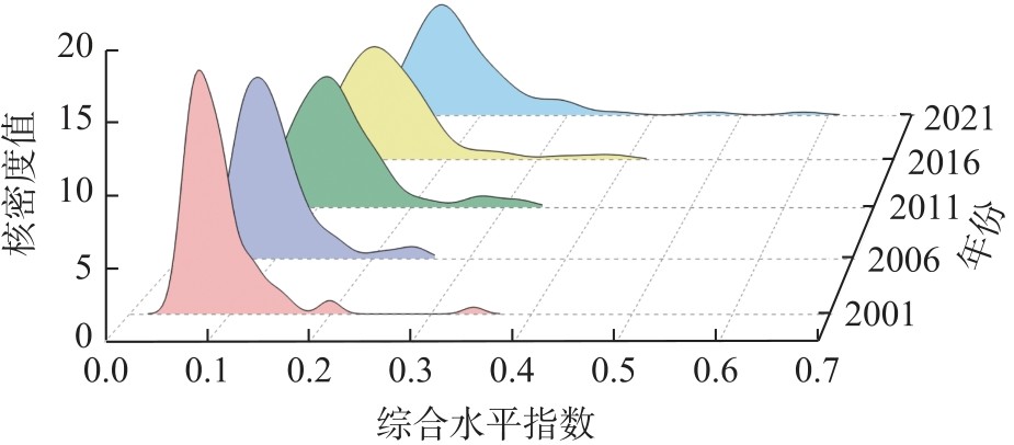
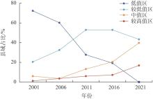
图8
城乡融合发展不同值区县域占比"
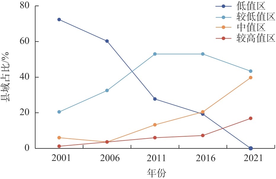
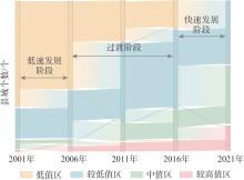
图9
城乡融合发展水平转移矩阵"
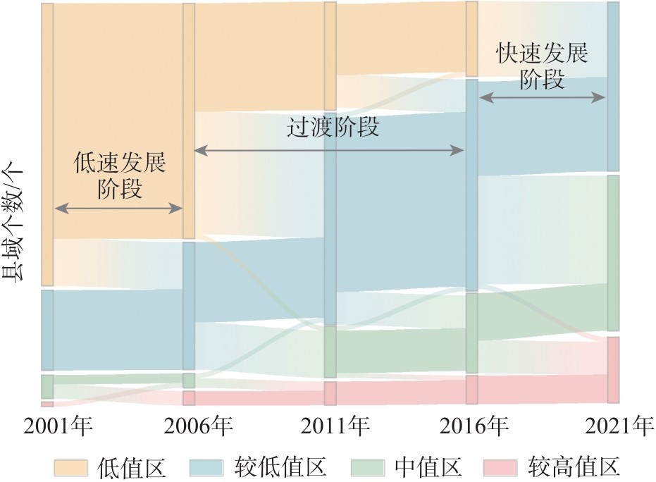
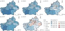
图10
耦合协调水平"
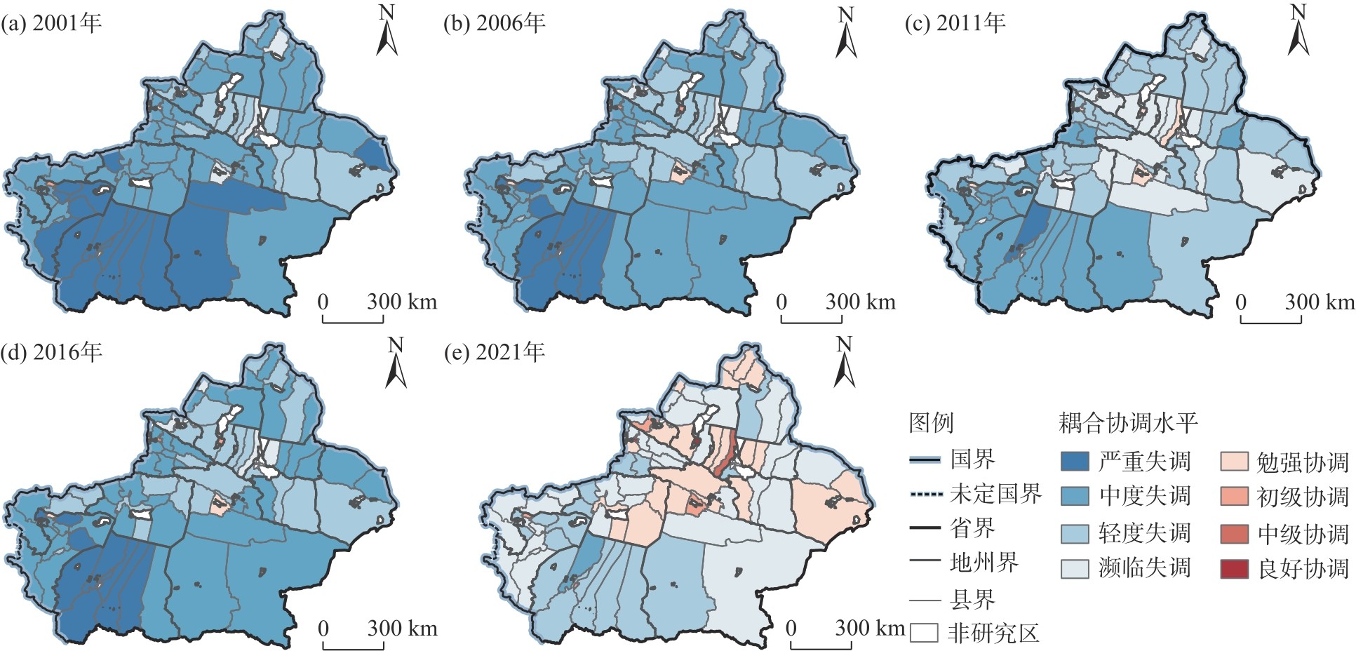
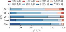
图11
耦合协调水平占比"
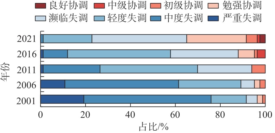
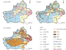
图12
新疆城乡融合发展水平分区与空间发展条件"
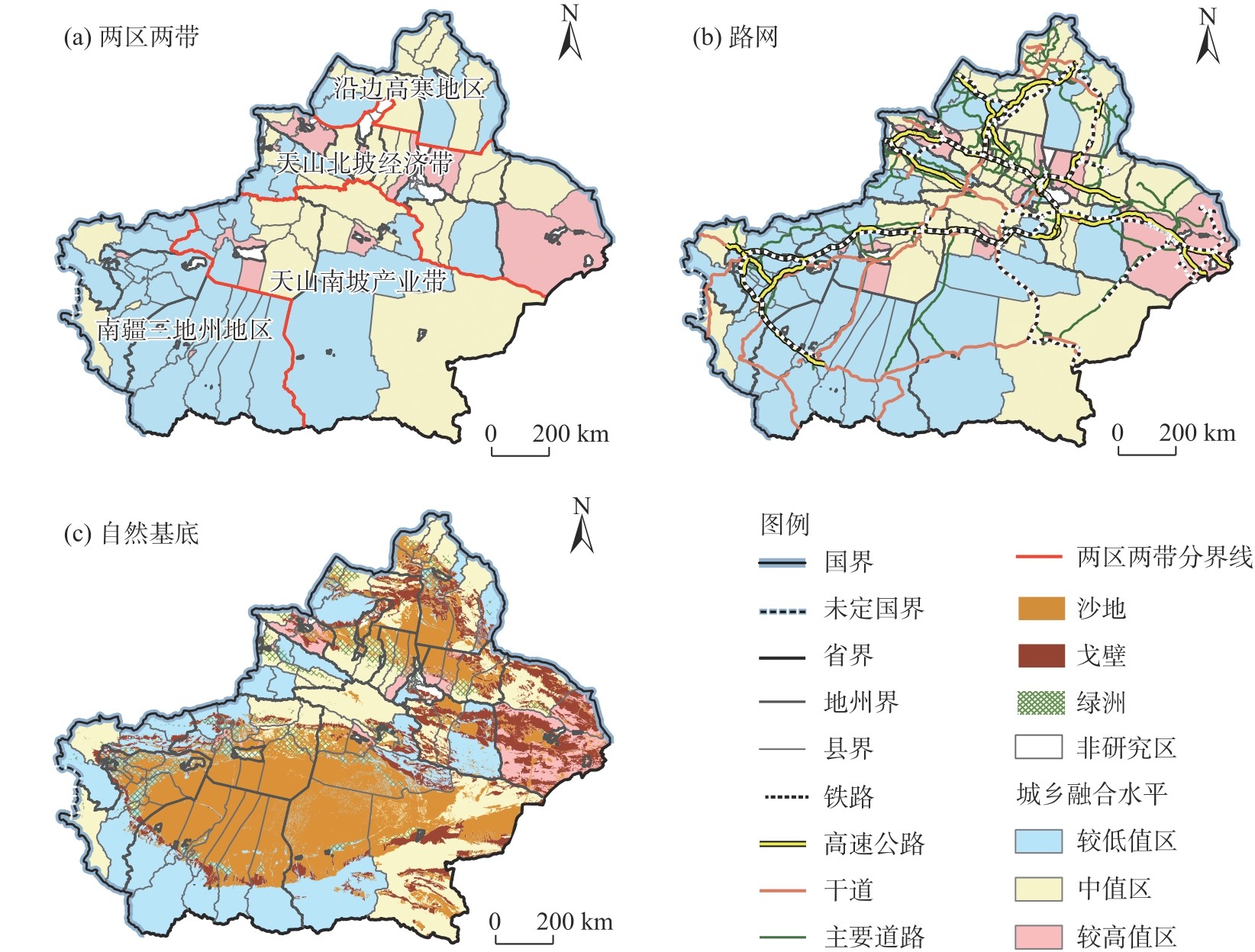
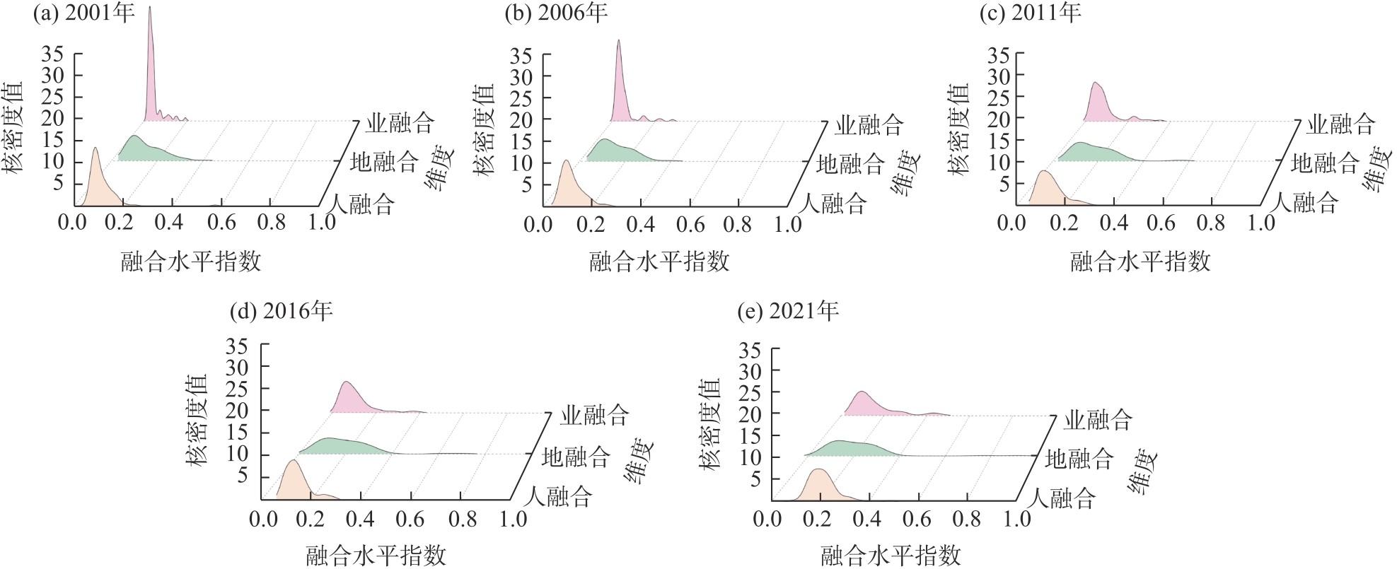
图13
“人-地-业”核密度分析"
| [1] | Zhang C, Fan Y P, Fang C L. Orderly and synergistic development of urban-rural integration based on evolutionary game model: A case study in the Jiangxi Province, China[J]. Land Use Policy, 2024, 146: 107331, doi: 10.1016/j.landusepol.2024.107331. |
| [2] | 秦昕, 涂维亮. 湖北省城乡融合发展的水平测度、区域差异及影响因素[J]. 湖北农业科学, 2025, 64(4): 211-217. |
| [Qin Xin, Tu Weiliang. Level measurement, regional differences and influencing factors of urban-rural integration in Hubei Province[J]. Hubei Agricultural Sciences, 2025, 64(4): 211-217.] | |
| [3] | 钱文荣, 仇焕广, 司伟, 等. 深化经济体制改革, 促进城乡融合发展——学习贯彻党的二十届三中全会精神笔谈[J]. 中国农村观察, 2024(5): 2-18. |
| [Qian Wenrong, Qiu Huanguang, Si Wei, et al. Deepening the reform of the economic system and promoting the integrated development of urban and rural areas: Study and practice the spirit of the third plenary session of the 20th CPC Central Committee[J]. China Rural Survey, 2024(5): 2-18.] | |
| [4] |
崔树强, 周国华, 李晓青, 等. “人-地-业”协调视角下长株潭城市群城乡融合发展仿真模拟[J]. 地理科学进展, 2024, 43(7): 1337-1354.
doi: 10.18306/dlkxjz.2024.07.006 |
|
[Cui Shuqiang, Zhou Guohua, Li Xiaoqing, et al. Simulation of urban-rural integration development of Changsha-Zhuzhou-Xiangtan urban agglomeration from the perspective of “human-land-industry” coordination[J]. Progress in Geography, 2024, 43(7): 1337-1354.]
doi: 10.18306/dlkxjz.2024.07.006 |
|
| [5] |
Yang Y Y, Liu Y S, Li Y R, et al. Measure of urban-rural transformation in Beijing-Tianjin-Hebei region in the new millennium: Population-land-industry perspective[J]. Land Use Policy, 2018, 79: 595-608.
doi: 10.1016/j.landusepol.2018.08.005 |
| [6] | Shan B Y, Zhang Q, Ren Q X, et al. Spatial heterogeneity of urban-rural integration and its influencing factors in Shandong Province of China[J]. Scientific Reports, 2022, 12(1): 14317, doi: 10.1038/s41598-022-18424-0. |
| [7] |
Zhang S, Chen W, Li Q, et al. Evaluation and development strategy of urban-rural integration under ecological protection in the Yellow River Basin, China[J]. Environmental Science and Pollution Research, 2023, 30(40): 92674-92691.
doi: 10.1007/s11356-023-28950-7 |
| [8] | 牛志勇. 城乡融合背景下人口双向流动与融合制度体系构建[J]. 农业经济, 2023(3): 96-98. |
| [Niu Zhiyong. Bidirectional population mobility and the construction of an integration system framework in the context of urban-rural integration[J]. Agricultural Economy, 2023(3): 96-98.] | |
| [9] |
龙花楼, 陈坤秋. 基于土地系统科学的土地利用转型与城乡融合发展[J]. 地理学报, 2021, 76(2): 295-309.
doi: 10.11821/dlxb202102004 |
|
[Long Hualou, Chen Kunqiu. Urban-rural integrated development and land use transitions: A perspective of land system science[J]. Acta Geographica Sinica, 2021, 76(2): 295-309.]
doi: 10.11821/dlxb202102004 |
|
| [10] |
邹利林, 林程, 王建英, 等. 中国城乡土地利用公平测评及时空跃迁与优化路径[J]. 地理学报, 2025, 80(11): 2847-2868.
doi: 10.11821/dlxb202511001 |
|
[Zou Lilin, Lin Cheng, Wang Jianying, et al. Spatio-temporal characteristics and optimization path of land use equity between urban and rural areas in China[J]. Acta Geographica Sinica, 2025, 80(11): 2847-2868.]
doi: 10.11821/dlxb202511001 |
|
| [11] |
方创琳, 孙彪. 新质生产力的地理学内涵及驱动城乡融合发展的重点方向[J]. 地理学报, 2024, 79(6): 1357-1370.
doi: 10.11821/dlxb202406001 |
|
[Fang Chuanglin, Sun Biao. The connotation of new quality productive forces and research priorities for driving urban-rural integrated development from the geographical perspective[J]. Acta Geographica Sinica, 2024, 79(6): 1357-1370.]
doi: 10.11821/dlxb202406001 |
|
| [12] | 刘肖, 金浩. 产业协同集聚与城镇化耦合的经济增长效应[J]. 西北人口, 2021, 42(5): 16-29. |
| [Liu Xiao, Jin Hao. Economic growth effect of co-agglomeration and urbanization coupling interaction[J]. Northwest Population Journal, 2021, 42(5): 16-29.] | |
| [13] | Tian J, Ma J Q, Zeng S P, et al. Characteristics and driving factors of the spatial and temporal evolution of county urban-rural integration-evidence from the Beijing-Tianjin-Hebei region, China[J]. Land, 2025, 14(8): 1563, doi: 10.3390/land14081563. |
| [14] | Muga G B, Hu S G, Wang Z L, et al. The efficiency of urban-rural integration in the Yangtze River Economic Belt and its optimization[J]. Sustainability, 2023, 15(3): 2419, doi: 10.3390/su15032419. |
| [15] | Xu J, Zeng Z J, Xi Z H, et al. Research on sustainable urban-rural integration development: Measuring levels, influencing factors, and exploring driving mechanisms-taking eight cities in the Greater Bay Area as examples[J]. Sustainability, 2024, 16(8): 3357, doi: 10.3390/su16083357. |
| [16] | 王武林, 罗婉璐, 周伟健. 福建省县域城乡融合时空演变与跃迁机制[J]. 人文地理, 2025, 40(1): 113-123. |
| [Wang Wulin, Luo Wanlu, Zhou Weijian. Spatio-temporal evolution and transition mechanism of urban-rural integration in county territory of Fujian Province[J]. Human Geography, 2025, 40(1): 113-123.] | |
| [17] | Yang Y Y, Bao W K, Wang Y S, et al. Measurement of urban-rural integration level and its spatial differentiation in China in the new century[J]. Habitat International, 2021, 117: 102420, doi: 10.1016/j.habitatint.2021.102420. |
| [18] |
He Y H, Zhou G H, Tang C L, et al. The spatial organization pattern of urban-rural integration in urban agglomerations in China: An agglomeration-diffusion analysis of the population and firms[J]. Habitat International, 2019, 87: 54-65.
doi: 10.1016/j.habitatint.2019.04.003 |
| [19] | Liu N N, Chen Y Y, Su F. Research on the spatial differences and influencing factors of integrated urban-rural development in the Yangtze River Delta[J]. Frontiers in Sustainable Cities, 2023, 4: 1077653, doi: 10.3389/frsc.2022.1077653. |
| [20] | Niu B, Ge D Z, Sun J W, et al. Multi-scales urban-rural integrated development and land-use transition: The story of China[J]. Habitat International, 2023, 132: 102744, doi: 10.1016/j.habitatint.2023.102744. |
| [21] |
Liu X G, Luo Y X, Zhu Y F, et al. Research on the measurement and effects of urban-rural integration and modernization in national central cities[J]. Social Indicators Research, 2024, 173(3): 827-866.
doi: 10.1007/s11205-024-03357-0 |
| [22] | Chen X F, Yu G X. The impact of urban-rural integration on food security: Evidence from provincial panel data in China[J]. Sustainability, 2024, 16(9): 3815, doi: 10.3390/su16093815. |
| [23] | Qin Y, Xu J L, Zhang H X, et al. The measurement of the urban-rural integration level of resource-exhausted cities: A case study of Zaozhuang City, China[J]. Sustainability, 2023, 15(1): 418, doi: 10.3390/su15010418. |
| [24] | 蔡金芳, 王志强. 新疆城乡融合发展水平测度与影响因素研究[J]. 农村经济与科技, 2024, 35(3): 89-91, 98. |
| [Cai Jinfang, Wang Zhiqiang. Research on the measurement and influencing factors of urban-rural integration development in Xinjiang[J]. Rural Economy and Science-Technology, 2024, 35(3): 89-91, 98.] | |
| [25] | 王继伟, 吴文婕. 基于TOPSIS模型的新疆县域城乡融合水平评价[J]. 农村经济与科技, 2024, 35(20): 104-110. |
| [Wang Jiwei, Wu Wenjie. Evaluation of urban-rural integration levels in Xinjiang counties using the TOPSIS model[J]. Rural Economy and Science-Technology, 2024, 35(20): 104-110.] | |
| [26] | 高强, 薛洲. 以县域城乡融合发展引领乡村振兴: 战略举措和路径选择[J]. 经济纵横, 2022(12): 17-24. |
| [Gao Qiang, Xue Zhou. Leading rural revitalization with county urban-rural integrated development: Strategic measures and path selection[J]. Economic Review Journal, 2022(12): 17-24.] | |
| [27] |
龙花楼, 徐雨利, 郑瑜晗, 等. 中国式现代化下的县域城乡融合发展[J]. 经济地理, 2023, 43(7): 12-19.
doi: 10.15957/j.cnki.jjdl.2023.07.002 |
|
[Long Hualou, Xu Yuli, Zheng Yuhan, et al. Urban-rural integrated development at county level under Chinese path to modernization[J]. Economic Geography, 2023, 43(7): 12-19.]
doi: 10.15957/j.cnki.jjdl.2023.07.002 |
|
| [28] |
Peng L A, Sun N, Jiang Z D, et al. The impact of urban-rural integration on carbon emissions of rural household energy consumption: Evidence from China[J]. Environment, Development and Sustainability, 2025, 27(1): 1799-1827.
doi: 10.1007/s10668-023-03944-0 |
| [29] | Niu Y C, Zhao L, Xie J X, et al. Population-land-industry-facility system coupling coordination and influencing factors in Hebei Province[J]. Land, 2025, 14(10): 2043, doi: 10.3390/land1410-20-43. |
| [30] | Ma L B, Chen M M, Che X L, et al. Research on population-land-industry relationship pattern in underdeveloped regions: Gansu Province of western China as an example[J]. Sustainability, 2019, 11(8): 2434, doi: 10.3390/su11082434. |
| [31] |
陆大道, 郭来喜. 地理学的研究核心—人地关系地域系统——论吴传钧院士的地理学思想与学术贡献[J]. 地理学报, 1998, 53(2): 97-105.
doi: 10.11821/xb199802001 |
|
[Lu Dadao, Guo Laixi. Man-earth areal system: The core of geographical study: On the geographical thoughts and academic contributions of academician Wu Chuanjun[J]. Acta Geographica Sinica, 1998, 53(2): 97-105.]
doi: 10.11821/xb199802001 |
|
| [32] |
周德, 戚佳玲, 钟文钰. 城乡融合评价研究综述: 内涵辨识、理论认知与体系重构[J]. 自然资源学报, 2021, 36(10): 2634-2651.
doi: 10.31497/zrzyxb.20211013 |
|
[Zhou De, Qi Jialing, Zhong Wenyu. Review of urban-rural integration evaluation: Connotation identification, theoretical analysis, and system reconstruction[J]. Journal of Natural Resources, 2021, 36(10): 2634-2651.]
doi: 10.31497/zrzyxb.20211013 |
|
| [33] | Li J T, Yang Y Y, Jiang N. County-rural transformation development from viewpoint of “population-land-industry” in Beijing-Tianjin-Hebei region under the background of rapid urbanization[J]. Sustainability, 2017, 9(9): 1637, doi: 10.3390/su9091637. |
| [34] | 郑万吉, 叶阿忠. 城乡收入差距、产业结构升级与经济增长——基于半参数空间面板VAR模型的研究[J]. 经济学家, 2015(10): 61-67. |
| [Zheng Wanji, Ye Azhong. Urban-rural income gap, industrial structure upgrading, and economic growth: An empirical study based on a semi-parametric spatial panel VAR model[J]. Economist, 2015(10): 61-67.] | |
| [35] |
杨婕, 戈大专, 孙攀, 等. 基于“人口-土地-资本”要素流动的城乡融合发展机制——以江西省为例[J]. 资源科学, 2025, 47(1): 110-124.
doi: 10.18402/resci.2025.01.09 |
|
[Yang Jie, Ge Dazhuan, Sun Pan, et al. The mechanism of urban-rural integrated development based on the “population-land-capital” factor flow: A case study of Jiangxi Province[J]. Resources Science, 2025, 47(1): 110-124.]
doi: 10.18402/resci.2025.01.09 |
|
| [36] | 林聚任, 张璐. 流动社会学视角下县域人口要素流动与城乡融合发展[J]. 济南大学学报(社会科学版), 2025, 35(5): 72-82. |
| [Lin Juren, Zhang Lu. Population factor mobility and urban-rural integrated development at the county level: From the perspective of mobility sociology[J]. Journal of University of Jinan (Social Science Edition), 2025, 35(5): 72-82.] | |
| [37] | 陈卫强, 笪晓军. 县域城乡融合发展的理论逻辑、现实困境及推进路径——基于“资源-产业-空间”的系统分析框架[J]. 农业经济问题, 2025(5): 94-106. |
| [Chen Weiqiang, Da Xiaojun. Theoretical logic, realistic dilemmas, and promotion paths of county-level urban-rural integrated development: A system analysis framework based on “resources-industry-space”[J]. Issues in Agricultural Economy, 2025(5): 94-106.] | |
| [38] | Huang L Y, Cao Y K. Review of the integrated development of ecological and cultural forestry[J]. Sustainability, 2022, 14(11): 6818, doi: 10.3390/su14116818. |
| [39] | 李琳, 黄拓夫, 欧阳晓. 中国县域城乡产业融合水平测度及其时空格局研究[J]. 地理研究, 2025, 44(4): 1119-1142. |
| [Li Lin, Huang Tuofu, Ouyang Xiao. Research on the measurement of the level and spatial and temporal pattern of urban and rural industrial integration in China[J]. Geographical Research, 2025, 44(4): 1119-1142.] | |
| [40] | Li M M, He B, Guo R Z, et al. Study on population distribution pattern at the county level of China[J]. Sustainability, 2018, 10(10): 3598, doi: 10.3390/su10103598. |
| [41] | Liu H, Lu G J, Luo K, et al. Measurement and spatio-temporal pattern evolution of urban-rural integration development in the Chengdu-Chongqing economic circle[J]. Land, 2024, 13(7): 942, doi: 10.3390/land13070942. |
| [42] | 柯新利, 邓洁, 宋钰. 长江经济带耕地利用绿色转型与城乡融合耦合协调发展的时空格局研究[J]. 生态学报, 2024, 44(13): 5773-5785. |
| [Ke Xinli, Deng Jie, Song Yu. Spatial-temporal pattern of coupling coordination between green transition of farmland use and urban-rural integration development in the Yangtze River Economic Belt[J]. Acta Ecologica Sinica, 2024, 44(13): 5773-5785.] | |
| [43] |
郑瑜晗, 龙花楼. 中国城乡融合发展测度评价及其时空格局[J]. 地理学报, 2023, 78(8): 1869-1887.
doi: 10.11821/dlxb202308002 |
|
[Zheng Yuhan, Long Hualou. Measurement and spatio-temporal pattern of urban-rural integrated development in China[J]. Acta Geographica Sinica, 2023, 78(8): 1869-1887.]
doi: 10.11821/dlxb202308002 |
|
| [44] | Xu C Y, Qian C, Yang W C, et al. Spatiotemporal pattern of urban-rural integration development and its driving mechanism analysis in Hangzhou bay urban agglomeration[J]. International Journal of Environmental Research and Public Health, 2022, 19(14): 8390, doi: 10.3390/ijerph19148390. |
| [45] | Wei L R, Zhao X J, Lu J X. Measuring the level of urban-rural integration development and analyzing the spatial pattern based on the new development concept: Evidence from cities in the Yellow River Basin[J]. International Journal of Environmental Research and Public Health, 2023, 20(1): 15, doi: 10.3390/ijerph20010015. |
| [46] |
周德, 戚佳玲, 钟文钰, 等. 城市群城乡融合发展: 测度评价、障碍因素与驱动因素[J]. 地理研究, 2023, 42(11): 2914-2939.
doi: 10.11821/dlyj020220537 |
| [Zhou De, Qi Jialing, Zhong Wenyu, et al. Urban and rural integration development in urban agglomerations: Measurement and evaluation, obstacle factors and driving factors[J]. Geographical Research, 2023, 42(11): 2914-2939.] | |
| [47] |
于雪霞, 周国华, 吴国华, 等. 中国中部农区城乡融合发展的时空特征及驱动机制[J]. 地理研究, 2025, 44(2): 400-418.
doi: 10.11821/dlyj020240420 |
| [Yu Xuexia, Zhou Guohua, Wu Guohua, et al. Spatiotemporal characteristics and driving mechanisms of urban-rural integrated development in rural areas of central China[J]. Geographical Research, 2025, 44(2): 400-418.] | |
| [48] | Massaquoi S M, Mande Z, Ge D D, et al. Does financial credit obtained from financial institutions influence agricultural productivity while balancing economic growth and sustainability? Empirical evidence from Sierra Leone using the VAR approach[J]. SAGE Open, 2025, 15(2): 21582440251342095, doi: 10.1177/2158244-0251342095. |
| [49] |
谭佳欣, 王凯. 武陵山区旅游化对城乡融合发展的影响机制研究[J]. 自然资源学报, 2025, 40(4): 1048-1067.
doi: 10.31497/zrzyxb.20250411 |
|
[Tan Jiaxin, Wang Kai. The impact mechanism of tourismfication on urban-rural integration development in the Wuling Mountain area[J]. Journal of Natural Resources, 2025, 40(4): 1048-1067.]
doi: 10.31497/zrzyxb.20250411 |
|
| [50] |
秦趣, 唐晓兵, 文斌. 伊犁地区旅游发展水平与乡村振兴耦合机制及实证研究[J]. 干旱区地理, 2026, 49(6): 1277-1281.
doi: 10.12118/j.issn.1000-6060.2025.392 |
| [Qin Qu, Tang Xiaobing, Wen Bin. Empirical study on the coupling mechanism of tourism development level and rural revitalization in lli region[J]. Arid Land Geography, 2026, 49(6): 1277-1287.] | |
| [51] | Ma L B, Li J Y, Wang X, et al. Evolution and simulation optimization of rural settlements in urban-rural integration areas from a multi-gradient perspective: A case study of the Lan-Bai urban agglomeration in China[J]. Habitat International, 2024, 153: 103203, doi: 10.1016/j.habitatint.2024.103203. |
| [52] |
Li C X, Wu J Y. Land use transformation and eco-environmental effects based on production-living-ecological spatial synergy: Evidence from Shaanxi Province, China[J]. Environmental Science and Pollution Research, 2022, 29(27): 41492-41504.
doi: 10.1007/s11356-022-18777-z |
| [53] | Fang X, Shi X Y, Phillips T K, et al. The coupling coordinated development of urban environment towards sustainable urbanization: An empirical study of Shandong Peninsula, China[J]. Ecological Indicators, 2021, 129: 107864, doi: 10.1016/j.ecolind.2021.107864. |
| [54] |
王颖, 孙平军, 李诚固, 等. 2003年以来东北地区城乡协调发展的时空演化[J]. 经济地理, 2018, 38(7): 59-66.
doi: 10.15957/j.cnki.jjdl.2018.07.008 |
|
[Wang Ying, Sun Pingjun, Li Chenggu, et al. Spatial-temporal evolution features of urban and rural harmonious in northeast China since 2003[J]. Economic Geography, 2018, 38(7): 59-66.]
doi: 10.15957/j.cnki.jjdl.2018.07.008 |
|
| [55] |
刘潇, 张新焕, 陈洋, 等. “乡镇-县域-绿洲”视角下新疆城乡融合的空间条件测度研究[J]. 干旱区地理, 2026, 49(5): 1039-1051.
doi: 10.12118/j.issn.1000-6060.2025.361 |
|
[Liu Xiao, Zhang Xinhuan, Chen Yang, et al. Measurement of spatial conditions for urban-rural integration in Xinjiang from the perspective of “township-county-oasis”[J]. Arid Land Geography, 2026, 49(5): 1039-1051.]
doi: 10.12118/j.issn.1000-6060.2025.361 |
| [1] | 仝雁军, 袁露, 雷军. 边疆安全背景下新疆边境人口-社会经济-资源环境耦合协调关系研究[J]. 干旱区地理, 2026, 49(8): 1626-1639. |
| [2] | 王紫洋, 夏咏, 王福红, 丁宁, 吕毅, 苏泽琛. 新疆县域耕地利用生态效率时空演变及驱动因素[J]. 干旱区地理, 2026, 49(7): 1385-1394. |
| [3] | 宁雅萱, 尹豪, 李金诺. 中国北方农牧交错带中段新型城镇化与农业生态系统服务耦合分析[J]. 干旱区地理, 2026, 49(7): 1457-1469. |
| [4] | 李文君, 张维梅. 中国数字经济与共同富裕的耦合协调关系及时空演进趋势[J]. 干旱区地理, 2026, 49(7): 1481-1492. |
| [5] | 陈亚宁, 朱成刚, 李稚, 方功焕. 新疆高质量发展的水资源潜力挖掘分析[J]. 干旱区地理, 2026, 49(6): 1101-1107. |
| [6] | 刘潇, 张新焕, 陈洋, 闫海龙. “乡镇-县域-绿洲”视角下新疆城乡融合的空间条件测度研究[J]. 干旱区地理, 2026, 49(5): 1039-1051. |
| [7] | 白洋, 赵平, 李永峰, 陈明珠, 孙艺玥. 新疆地质旅游空间协同区划研究[J]. 干旱区地理, 2026, 49(5): 1074-1086. |
| [8] | 王伟军, 李娟, 李花. 黄河流域旅游-生态-福祉耦合协调的多尺度时空演化及分异机理[J]. 干旱区地理, 2026, 49(4): 683-696. |
| [9] | 王慧丽, 李妞, 刘英, 刘咏涵. 黄河流域水资源-生态韧性动态耦合与级层障碍解析[J]. 干旱区地理, 2026, 49(3): 569-580. |
| [10] | 欧开航, 方世巧, 程乾, 周徐帆. 农村公共服务与乡村旅游耦合协调度及其乡村振兴影响效应——基于西部地区的实证[J]. 干旱区地理, 2026, 49(2): 404-415. |
| [11] | 孙国军, 李家瑶, 王子轩. 黄河流域数文旅产业发展水平评价与耦合协调时空特征分析[J]. 干旱区地理, 2026, 49(1): 117-127. |
| [12] | 朱怡婷, 梁桂仙, 周春山, 辛龙, 李金雪. 新疆文旅新质生产力发展时空演变特征与驱动因素[J]. 干旱区地理, 2026, 49(1): 128-139. |
| [13] | 阿力木·艾尔肯, 李如琦, 努尔扎提·阿卜杜柯尤木, 玛依热·艾海提, 希热娜依·铁里瓦尔地. 1961—2022年新疆南部降雨和极端降雨特征[J]. 干旱区地理, 2026, 49(1): 13-22. |
| [14] | 杨迪, 邹进, 马晓飞, 张珣, 周锐, 刘艳春, 石金莲. 体育旅游资源空间分布特征及可持续发展研究——以新疆为例[J]. 干旱区地理, 2026, 49(1): 140-150. |
| [15] | 刘全渝, 刘馨璐, 李桂真, 李从娟. 新疆表层土壤粒径分形特征及驱动因素分析[J]. 干旱区地理, 2026, 49(1): 56-68. |
|
||

