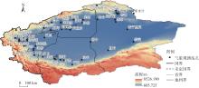
| [1] |
金晨, 何清, 黄乾. 新疆南部暴雨研究进展[J]. 大气科学学报, 2023, 46(1): 82-96.
|
|
[Jin Chen, He Qing, Huang Qian. A review on rainstorm research in southern Xinjiang[J]. Transactions of Atmospheric Sciences, 2023, 46(1): 82-96.]
|
| [2] |
姚俊强, 李漠岩, 迪丽努尔·托列吾别克, 等. 不同时间尺度下新疆气候“暖湿化”特征[J]. 干旱区研究, 2022, 39(2): 333-346.
doi: 10.13866/j.azr.2022.02.01
|
|
[Yao Junqiang, Li Moyan, Tuoliewubieke Dilinuer, et al. The assessment on “warming-wetting” trend in Xinjiang at multi-scale during 1961—2019[J]. Arid Zone Research, 2022, 39(2): 333-346.]
doi: 10.13866/j.azr.2022.02.01
|
| [3] |
魏艳英, 龚美玲, 李海花. 2010—2019年新疆南部致灾暴雨时空分布及其影响[J]. 干旱气象, 2021, 39(6): 930-938.
|
|
[Wei Yanying, Gong Meiling, Li Haihua. Spatial-temporal distribution and influence of disastrous rainstorm in southern Xinjiang during 2010—2019[J]. Journal of Arid Meteorology, 2021, 39(6): 930-938.]
|
| [4] |
杨霞, 许婷婷, 张林梅, 等. 不同气候背景下新疆南部暖季暴雨特征和差异[J]. 干旱气象, 2022, 40(2): 222-233.
doi: 10.11755/j.issn.1006-7639(2022)-02-0222
|
|
[Yang Xia, Xu Tingting, Zhang Linmei, et al. Characteristics and differences of rainstorm in the southern Xinjiang during warm season under different climatic backgrounds[J]. Journal of Arid Meteorology, 2022, 40(2): 222-233.]
|
| [5] |
杨霞, 周鸿奎, 许婷婷, 等. 新疆南部夏季不同类型暴雨精细化特征分析[J]. 干旱区研究, 2021, 38(3): 747-756.
doi: 10.13866/j.azr.2021.03.16
|
|
[Yang Xia, Zhou Hongkui, Xu Tingting, et al. Comparative analysis of the fine characteristics of different rainstorms in southern Xinjiang during summer[J]. Arid Zone Research, 2021, 38(3): 747-756.]
doi: 10.13866/j.azr.2021.03.16
|
| [6] |
张俊兰, 李伟, 郑育琳. 昆仑山北坡短时强降水天气分型及雷达回波特征分析[J]. 沙漠与绿洲气象, 2022, 16(1): 1-9.
|
|
[Zhang Junlan, Li Wei, Zheng Yulin. Analysis of weather classification and radar echo characteristics of short-term heavy precipitation in the northern Kunlun Mountains[J]. Desert and Oasis Meteorology, 2022, 16(1): 1-9.]
|
| [7] |
张俊兰, 杨霞, 施俊杰. 青藏高原天气系统对昆仑山北坡一次罕见暴雨过程影响分析[J]. 高原气象, 2021, 40(5): 1002-1011.
doi: 10.7522/j.issn.1000-0534.2020.00111
|
|
[Zhang Junlan, Yang Xia, Shi Junjie. Analysis of the influence of the Qinghai-Xizang Plateau weather system on a rare rainstorm process on the northern slope of Kunlun Mountain[J]. Plateau Meteorology, 2021, 40(5): 1002-1011.]
doi: 10.7522/j.issn.1000-0534.2020.00111
|
| [8] |
热孜瓦古·孜比布拉, 吕新生, 王鹏飞, 等. 2020年春季新疆南部西部一次极端暴雨成因分析[J]. 沙漠与绿洲气象, 2021, 15(3): 20-28.
|
|
[Zibibula Reziwagu, Lü Xinsheng, Wang Pengfei, et al. Analysis of an extreme rainstorm in the west of southern Xinjiang in spring 2020[J]. Desert and Oasis Meteorology, 2021, 15(3): 20-28.]
|
| [9] |
孙颖姝, 周玉淑, 王咏青. 一次双高空急流背景下新疆南部强降水事件的动力过程和水汽源分析[J]. 大气科学, 2019, 43(5): 1041-1054.
|
|
[Sun Yingshu, Zhou Yushu, Wang Yongqing. Analysis of dynamic process and moisture source on a heavy precipitation event in southern Xinjiang associated with the double upper-level Jet[J]. Chinese Journal of Atmospheric Sciences, 2019, 43(5): 1041-1054.]
|
| [10] |
努尔比亚·吐尼牙孜, 张超, 李泽巍, 等. 新疆南部西部2016年8月4次暴雨过程特征分析[J]. 干旱气象, 2019, 37(2): 301-311.
|
|
[Tunyaz Nurbiye, Zhang Chao, Li Zewei, et al. Characteristics of four rainstorm processes in the west of southern Xinjiang in August 2016[J]. Journal of Arid Meteorology, 2019, 37(2): 301-311.]
|
| [11] |
唐鹏, 黄艳, 张丽, 等. 中昆仑山北坡一次极端暴雨天气过程分析[J]. 沙漠与绿洲气象, 2022, 16(6): 34-41.
|
|
[Tang Peng, Huang Yan, Zhang Li, et al. Causation analysis of an extreme torrentaial rain on the north slope of middle Kunlun Mountain[J]. Desert and Oasis Meteorology, 2022, 16(6): 34-41.]
|
| [12] |
李如琦, 李桉孛, 李海花, 等. 塔克拉玛干沙漠南缘两次极端暴雨的气流模型与水汽输送特征[J]. 沙漠与绿洲气象, 2022, 16(6): 1-10.
|
|
[Li Ruqi, Li Anbei, Li Haihua, et al. Air flow model and water vapor transport characteristics of two extreme rainstorms in the southern edge of Taklimakan Desert[J]. Desert and Oasis Meteorology, 2022, 16(6): 1-10.]
|
| [13] |
杨霞, 张云惠, 张超, 等. 新疆南部西部“5·21”极端大暴雨成因分析[J]. 沙漠与绿洲气象, 2020, 14(1): 21-30.
|
|
[Yang Xia, Zhang Yunhui, Zhang Chao, et al. Causation analysis of the 21 May 2018 torrential rain in the west of southern Xinjiang[J]. Desert and Oasis Meteorology, 2020, 14(1): 21-30.]
|
| [14] |
张俊兰, 李如琦, 李娜, 等. 新疆塔里木盆地2021年“7·19”暴雨水汽特征的初步分析[J]. 大气科学, 2023, 47(2): 567-584.
|
|
[Zhang Junlan, Li Ruqi, Li Na, et al. Preliminary analysis of the water vapor characteristics of the “July 19” heavy rain in 2021 in the Tarim Basin Xinjiang[J]. Chinese Journal of Atmospheric Sciences, 2023, 47(2): 567-584.]
|
| [15] |
李海花, 李吉州, 刘大锋, 等. 阿克苏地区早春一次极端降水水汽特征分析[J]. 沙漠与绿洲气象, 2022, 16(6): 18-24.
|
|
[Li Haihua, Li Jizhou, Liu Dafeng, et al. Analysis of water vapor characteristics of an extreme precipitation in Aksu Area in early spring of 2022[J]. Desert and Oasis Meteorology, 2022, 16(6): 18-24.]
|
| [16] |
庄晓翠, 赵江伟, 李博渊, 等. 新疆南部西部暴雨过程水汽来源及输送特征[J]. 暴雨灾害, 2022, 41(5): 544-555.
|
|
[Zhuang Xiaocui, Zhao Jiangwei, Li Boyuan, et al. Characteristics of water vapor source and transport during rainstorm in western southern Xinjiang[J]. Torrential Rain and Disasters, 2022, 41(5): 544-555.]
|
| [17] |
莫绍青, 李耀辉. 新疆南部极端干旱区典型暴雨的水汽特征及触发机制分析[J]. 高原气象, 2023, 42(1): 82-97.
doi: 10.7522/j.issn.1000-0534.2022.00026
|
|
[Mo Shaoqing, Li Yaohui. Analysis of the water vapor characteristics and trigger mechanism for a typical heavy rainstorm in the extreme arid region of the southern Xinjiang[J]. Plateau Meteorology, 2023, 42(1): 82-97.]
doi: 10.7522/j.issn.1000-0534.2022.00026
|
| [18] |
庄晓翠, 李博渊, 赵江伟, 等. 基于HYSPLIT模式分析的塔克拉玛干沙漠南缘暴雨水汽特征[J]. 气象, 2022, 48(3): 311-323.
|
|
[Zhuang Xiaocui, Li Boyuan, Zhao Jiangwei, et al. Water vapor characteristics of rainstorm in southern Taklimakan Desert based on HYSPLIT model analysis[J]. Meteorlogical Monthly, 2022, 48(3): 311-323.]
|
| [19] |
庄晓翠, 李博渊, 赵江伟, 等. 天山南坡暖季暴雨过程的水汽来源及输送特征[J]. 干旱气象, 2022, 40(1): 30-40.
doi: 10.11755/j.issn.1006-7639(2022)-01-0030
|
|
[Zhuang Xiaocui, Li Boyuan, Zhao Jiangwei, et al. Water vapor source and transport characteristics of rainstorm processes in warm season on southern slope of the Tianshan Mountains[J]. Journal of Arid Meteorology, 2022, 40(1): 30-40.]
|
| [20] |
李海花, 闵月, 李桉孛, 等. 昆仑山北麓两次极端暴雨水汽特征对比分析[J]. 干旱区地理, 2022, 45(3): 715-724.
doi: 10.12118/j.issn.1000-6060.2021.397
|
|
[Li Haihua, Min Yue, Li Anbei, et al. Comparative analysis of on water vapor characteristics of two extreme rainstorms in the north slope of Kunlun Mountains[J]. Arid Land Geography, 2022, 45(3): 715-724.]
doi: 10.12118/j.issn.1000-6060.2021.397
|
| [21] |
牟欢, 赵丽, 王旭, 等. 基于拉格朗日方法的一次新疆南部西部特大暴雨水汽来源分析[J]. 冰川冻土, 2021, 43(4): 1157-1165.
doi: 10.7522/j.issn.1000-0240.2021.0037
|
|
[Mu Huan, Zhao Li, Wang Xu, et al. Water vapor source analysis of a severe torrential rain in the west of southern Xinjiang based on the Lagrangian method[J]. Journal of Glaciology and Geocryology, 2021, 43(4): 1157-1165.]
doi: 10.7522/j.issn.1000-0240.2021.0037
|
| [22] |
李娜, 秦贺, 李如琦, 等. 新疆夏季两例塔什干低涡天气过程对比分析[J]. 沙漠与绿洲气象, 2018, 12(6): 8-15.
|
|
[Li Na, Qin He, Li Ruqi, et al. Comparative analysis of the two cases of Tashkent vortex weather processes in summer in Xinjiang[J]. Desert and Oasis Meteorology, 2018, 12(6): 8-15.]
|
| [23] |
周雪英, 贾健, 刘国强, 等. 2017年春季新疆南部中部两次强降水天气环流配置及干冷空气侵入特征对比[J]. 气象科技, 2018, 46(6): 1201-1210.
|
|
[Zhou Xueying, Jia Jian, Liu Guoqiang, et al. Comparative analysis of circulation background and dry intrusion of two spring heavy rainfall events in south Xinjiang[J]. Meteorological Science and Technology, 2018, 46(6): 1201-1210.]
|
| [24] |
胡素琴, 希热娜依·铁里瓦尔地, 李娜, 等. 新疆南部西部干旱区两次极端暴雨过程对比分析[J]. 大气科学, 2022, 46(5): 1177-1197.
|
|
[Hu Suqin, Tiliwaldi Xerinay, Li Na, et al. Comparative analysis of two extreme rainstormsin the arid area of western south Xinjiang[J]. Chinese Journal of Atmospheric Sciences, 2022, 46(5): 1177-1197.]
|
| [25] |
希热娜依·铁里瓦尔地, 玛依热·艾海提, 孟凡雪, 等. 新疆南部西部两次极端暴雨中尺度特征对比分析[J]. 沙漠与绿洲气象, 2022, 16(5): 47-55.
|
|
[Tiliwaldi Xerinay, Ahat Mayire, Meng Fanxue, et al. Comparative analysis on environmental conditions and m esoscale characteristics of two extreme rainfall events in west of southern Xinjiang[J]. Desert and Oasis Meteorology, 2022, 16(5): 47-55.]
|
| [26] |
周括, 冉令坤, 蔡仁, 等. 地形追随垂直运动方程在新疆南部极端暴雨中的诊断分析[J]. 大气科学, 2022, 46(3): 745-761.
|
|
[Zhou Kuo, Ran Lingkun, Cai Ren, et al. Diagnostic analysis of terrain following vertical motion equation in southern Xinjiang extreme rainstorms[J]. Chinese Journal of Atmospheric Sciences, 2022, 46(3): 745-761.]
|
| [27] |
肖开提·多莱特. 新疆降水量级标准的划分[J]. 新疆气象, 2005, 28(3): 7-8.
|
|
[Duolaite Xiaokaiti. Formulation of precipitation intensity standard of Xinjiang[J]. Bimonthly of Xinjiang Meteorology, 2005, 28(3): 7-8.]
|
| [28] |
陈丹, 袁华江, 张永华, 等. 1960—2019年沙雅县极端天气的气候特征分析[J]. 沙漠与绿洲气象, 2020, 14(4): 94-99.
|
|
[Chen Dan, Yuan Huajiang, Zhang Yonghua, et al. Analysis of the extreme weather event in Shaya of Xinjiang from 1960 to 2019[J]. Desert and Oasis Meteorology, 2020, 14(4): 94-99.]
|
| [29] |
卢珊, 胡泽勇, 付春伟, 等. 黄土高原夏季极端降水及其成因分析[J]. 高原气象, 2022, 41(1): 241-254.
doi: 10.7522/j.issn.1000-0534.2021.00027
|
|
[Lu Shan, Hu Zeyong, Fu Chunwei, et al. Characteristics and possible causes for extreme precipitation in summer over the Loess Plateau[J]. Plateau Meteorology, 2022, 41(1): 241-254.]
doi: 10.7522/j.issn.1000-0534.2021.00027
|
 ), 李如琦2(