干旱区地理 ›› 2026, Vol. 49 ›› Issue (1): 23-34.doi: 10.12118/j.issn.1000-6060.2025.107 cstr: 32274.14.ALG2025107
李若楠1,2,3( ), 李均力1,3(), 刘帅琪1,2,3, 都伟冰4
收稿日期:2025-03-01
修回日期:2025-07-21
出版日期:2026-01-25
发布日期:2026-01-18
通讯作者:
李均力(1980-),男,博士,研究员,主要从事遥感信息提取、水资源遥感等方面的研究. E-mail: lijl@ms.xjb.ac.cn作者简介:李若楠(2001-),女,硕士研究生,主要从事干旱区冰川变化研究. E-mail: liruonan23@mails.ucas.ac.cn
基金资助:
LI Ruonan1,2,3(), LI Junli1,3(), LIU Shuaiqi1,2,3, DU Weibing4
Received:2025-03-01
Revised:2025-07-21
Published:2026-01-25
Online:2026-01-18
摘要:
木孜塔格峰冰川变化对南疆水资源具有重要影响。利用1960—2023年的多源遥感数据和深度学习方法提取木孜塔格峰区冰川的面积及末端变化,并分别从冰川单元和地形角度分析冰川变化的区域差异及驱动因素。结果表明:(1)1960—2023年木孜塔格峰冰川总体上呈现退缩趋势,冰川面积退缩速率为0.83 km2·a-1,冰川末端退缩速率为2.21 m·a-1,与中国西北其他冰川相比变化幅度较小。(2)从冰川内部的区域差异来看,冰川面积退缩速率在南向和东向较大,且随海拔和坡度的增加而减小;而冰川末端退缩速率在东、西坡向(4.42 m·a-1和4.01 m·a-1)高于南、北坡向(1.63 m·a-1和1.45 m·a-1)。(3)木孜塔格峰区冰川面积和末端区域变化差异主要受到地形与气候作用的影响,阳坡受更多太阳辐射导致加速融化,低海拔区域则因气温上升而更易发生退缩。研究结果为理解高寒山区冰川对气候变化的响应机制提供了科学依据,对南疆地区水资源管理及生态安全评估具有重要参考价值。
李若楠, 李均力, 刘帅琪, 都伟冰. 1960—2023年木孜塔格峰冰川变化及其地形因素分析[J]. 干旱区地理, 2026, 49(1): 23-34.
LI Ruonan, LI Junli, LIU Shuaiqi, DU Weibing. Glacier changes and topographic factors of the Ulugh Muztagh from 1960 to 2023[J]. Arid Land Geography, 2026, 49(1): 23-34.
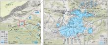
图1
研究区示意图"

表1
冰川制图选择的遥感数据"
| 年份 | 影像日期(年-月-日) | 来源 | 轨道号/行号或网格编号 | 分辨率/m |
|---|---|---|---|---|
| 1960 | - | 地形图 | - | 10 |
| 1986 | 1986-11-08 | Landsat | 141/035 | 30 |
| 1995 | 1995-03-22 | Landsat | 141/035 | 30 |
| 2004 | 2004-09-14 | Landsat | 141/035 | 30 |
| 2015 | 2015-08-20 | Landsat | 141/035 | 30 |
| 2023 | 2023-09-07 | Sentinel | T45SWA | 10 |
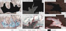
图2
冰川边界制图结果"

表2
不同遥感数据的冰川制图精度对比"
| 数据类别 | 评价指标 | ||||
|---|---|---|---|---|---|
| PA | UA | OA | F1 | IoU | |
| Sentinel-2 | 0.831 | 0.851 | 0.950 | 0.835 | 0.768 |
| Landsat-5\7\8 | 0.748 | 0.832 | 0.916 | 0.780 | 0.679 |
表3
不同时间段冰川面积变化及退缩特征"
| 年份 | 面积/km2 | 变化量 /km2 | 退缩速率 /km2·a-1 | 退缩率 /% | 年均退缩 率/%·a-1 |
|---|---|---|---|---|---|
| 1960 | 703.51±6.97 | - | - | - | - |
| 1986 | 678.32±12.83 | -25.19 | 0.97 | 3.58 | 0.14 |
| 1995 | 674.94±12.71 | -3.38 | 0.38 | 0.50 | 0.06 |
| 2004 | 671.48±13.43 | -3.46 | 0.38 | 0.51 | 0.06 |
| 2015 | 663.85±14.31 | -7.63 | 0.69 | 1.14 | 0.10 |
| 2023 | 651.50±5.83 | -12.35 | 1.54 | 1.86 | 0.23 |
| 总计 | - | -52.01 | 0.83 | 7.39 | 0.12 |
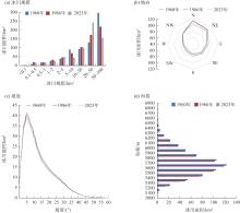
图3
1960—2023年不同规模、坡向、坡度和海拔的冰川面积分布"
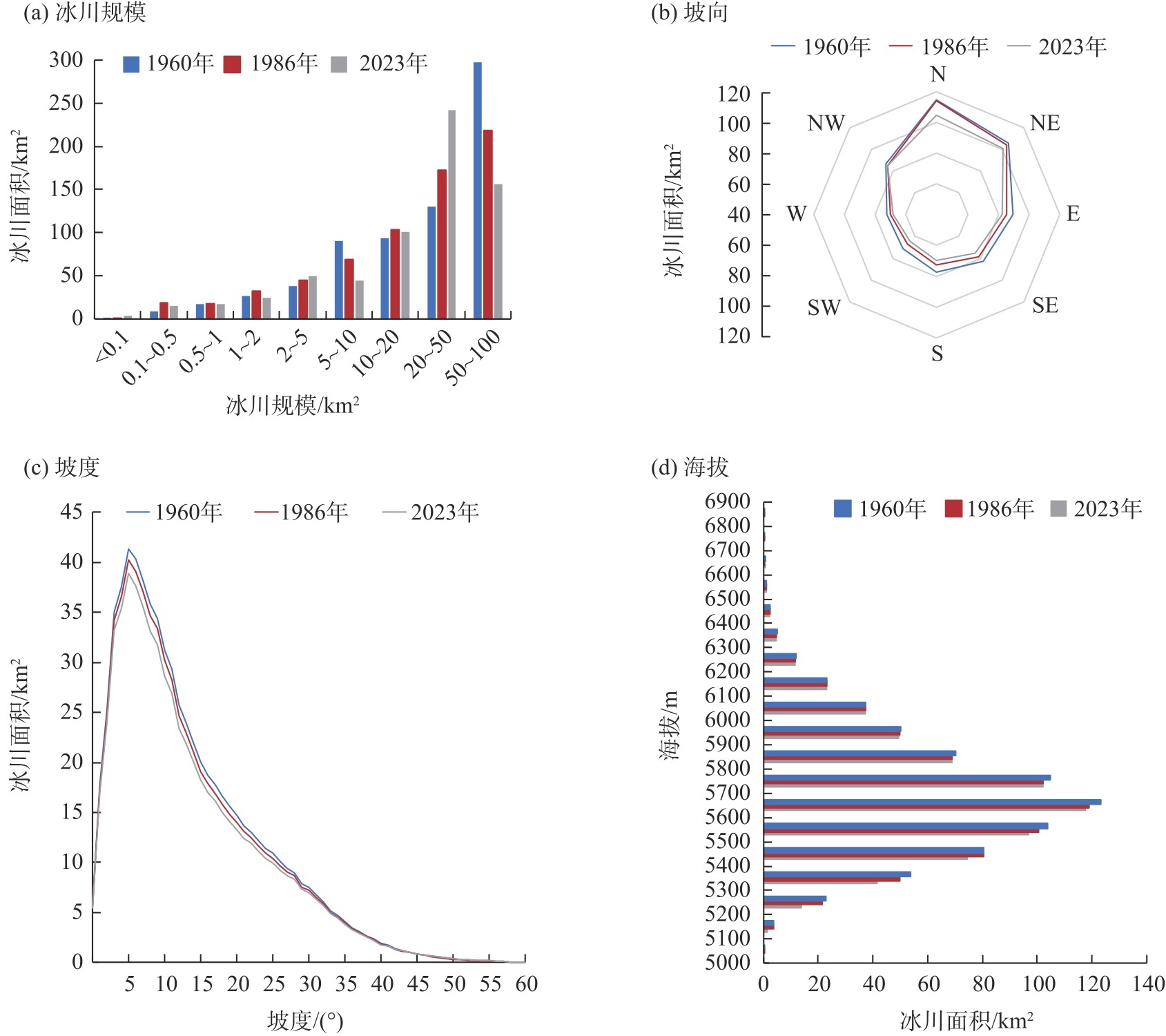
图4
1960—2023年不同坡向、坡度和海拔的冰川面积退缩量及退缩率"
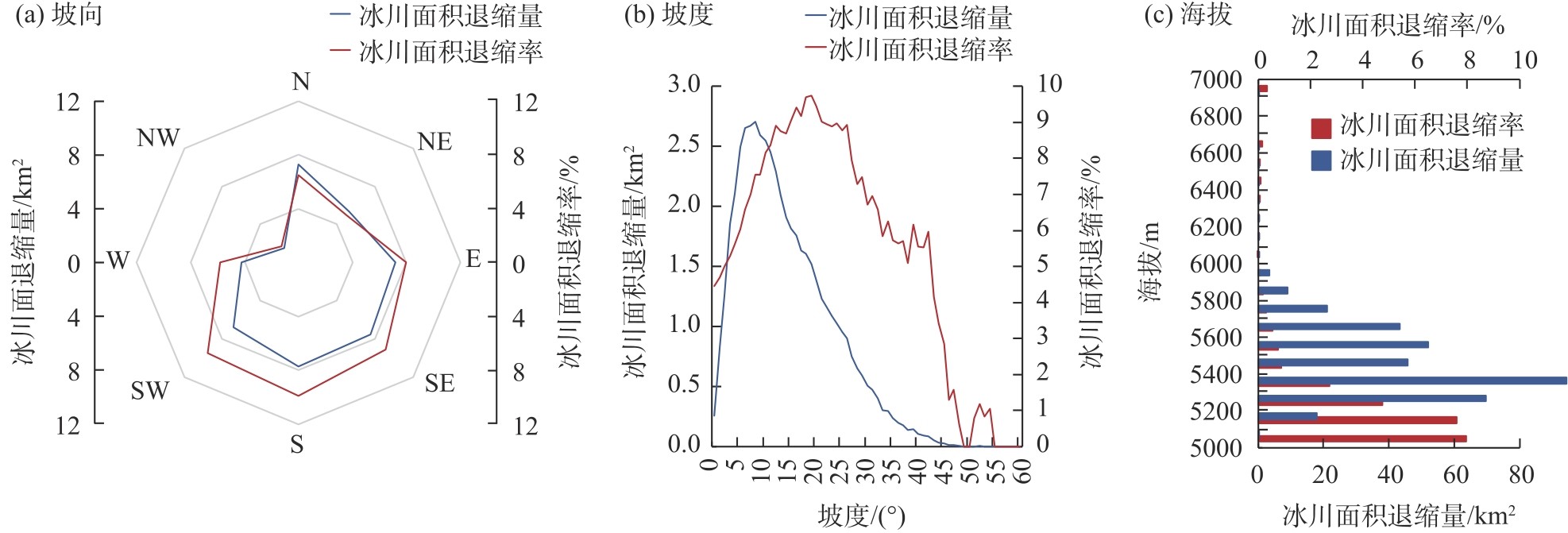
图5
冰舌末端变化的区域差异"
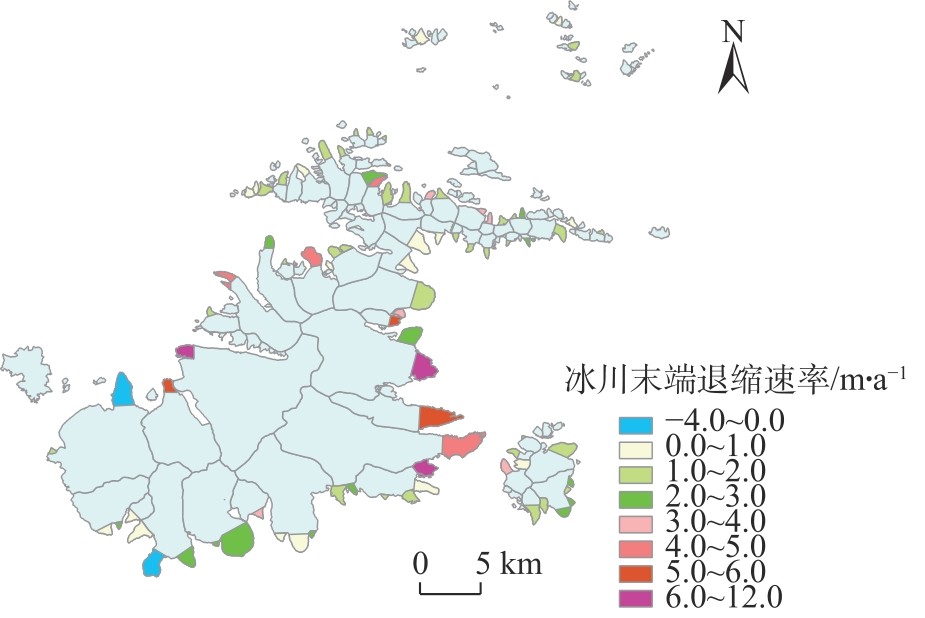
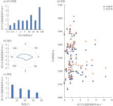
图6
84个典型冰川在不同规模、坡向、坡度和海拔的末端退缩速率"
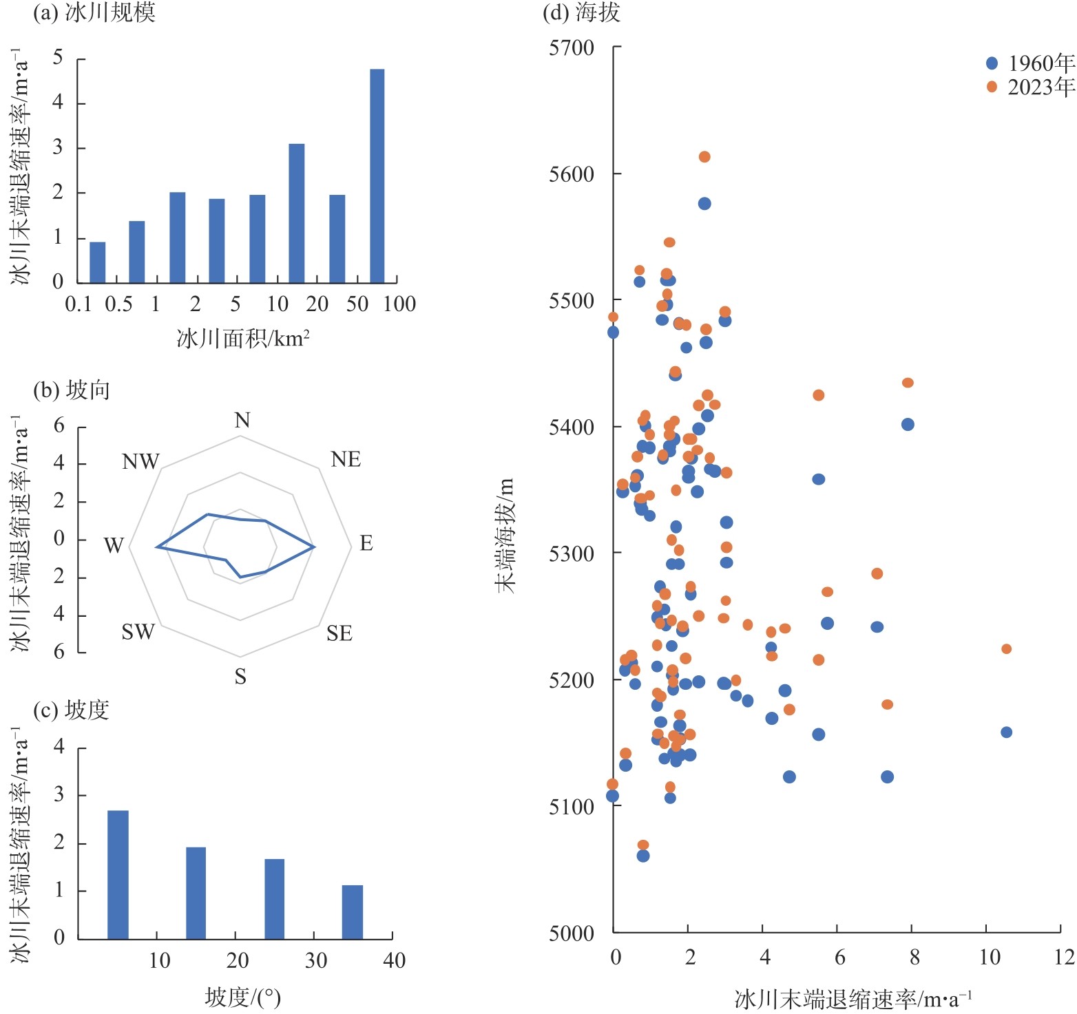
表4
地形因子与冰川面积及末端退缩的相关性和显著性"
| 因子 | 冰川规模 | 最小海拔 | 最大海拔 | 平均海拔 | 平均坡度 | 南北向 | 东西向 |
|---|---|---|---|---|---|---|---|
| 面积退缩量 | 0.58*** | -0.21* | 0.69*** | 0.26** | -0.27** | 0.15 | -0.02 |
| 面积退缩率 | -0.28** | -0.08 | -0.31** | -0.34*** | 0.29** | 0.10 | -0.10 |
| 末端退缩速率 | 0.37** | -0.21 | 0.51*** | 0.28** | 0.03 | 0.11 | 0.10 |
表5
中国西部主要山系的年平均气温与年平均降水量"
| 山系 | 年平均气温/℃ | 年平均降水量/mm | 数据来源 |
|---|---|---|---|
| 木孜塔格山 | -11.5 | 413 | 车彦军等[ |
| 阿尔泰山 | -8.0~4.1 | 75~700 | 戴玉萍等[ |
| 天山 | 8.0 | 500~1200 | 邢武成等[ |
| 阿尔金山 | 3.5 | 50~100 | 张聪等[ |
| 祁连山 | 4.0 | 250 | 程锦泉 [ |
| 东昆仑山 | 0.0~8.0 | 500~800 | 李成秀[ |
| 中昆仑山 | 0.0~8.0 | 100 | 李成秀[ |
| 西昆仑山 | 0.0~8.0 | 20 | 李成秀[ |
| 喀喇昆仑山北坡 | 0.0~6.0 | 600 | 李海娟[ |
| 唐古拉山 | -1.6 | 420 | 张裕[ |
| 念青唐古拉山 | -1.0 | 400~700 | 李亚鹏等[ |
| 喜马拉雅山(珠峰绒布河流域) | 2.0 | 371 | 刘玉婷等[ |
表6
中国西部山脉和典型地区冰川的退缩速率"
| 山脉 | 典型区域 | 最高海拔/m | 平均海拔/m | 研究时段 | 冰川面积年均退缩率/%·a-1 | 数据来源 |
|---|---|---|---|---|---|---|
| 中昆仑山 | 木孜塔格山区 | 6973 | 5557 | 1960—2023 | 0.12 | 本研究 |
| 阿尔泰山 | 友谊峰 | 4374 | - | 1959—2008 | 0.39 | 骆书飞等[ |
| 天山 | 阿克苏河流域 | - | 2233 | 1975—2016 | 0.63 | Zhang等[ |
| 依连哈比尔尕山 | 4590 | - | 2016—2022 | 0.75 | 李若楠等[ | |
| 阿尔金山 | 西段 | 6228 | 5800 | 1973—2020 | 0.44 | 田洪阵等[ |
| 中段 | - | 4000~4200 | 1973—2020 | 0.32 | 田洪阵等[ | |
| 东段 | - | 5177 | 1973—2020 | 0.62 | 田洪阵等[ | |
| 祁连山 | 团结峰地区 | 5826 | - | 1966—2020 | 0.32 | 石梦寒[ |
| 西昆仑山 | 昆仑峰区 | 7167 | - | 1976—2010 | 0.12 | 李成秀等[ |
| 中昆仑山 | 布喀塔格峰 | 6860 | - | 1973—2010 | 0.14 | 姜珊[ |
| 马兰冰帽 | 6056 | - | 1973—2010 | 0.16 | 姜珊[ | |
| 喀喇昆仑山 | 克勒青河流域 | 8611 | 5400 | 1978—2015 | 0.22 | 许艾文等[ |
| 克勒青河流域 | 8611 | 5400 | 2000—2016 | 0.14 | 王盼盼[ | |
| 唐古拉山 | 格拉丹东地区 | 6621 | 5182~6621 | 1990—2015 | 0.26 | 王聪强等[ |
| 冬克玛底地区 | 6100 | 5173~6100 | 1990—2015 | 0.68 | 王聪强等[ | |
| 布加岗日地区 | 6328 | 4175~6328 | 1990—2015 | 0.75 | 王聪强等[ | |
| 中段 | - | - | 1990—2015 | 0.89 | 王聪强等[ | |
| 念青唐古拉山 | 西段 | 7093 | - | 1976—2011 | 0.59 | 冀琴等[ |
| 东部 | - | - | 1999—2015 | 1.24 | Ji等[ | |
| 纳木错流域 | - | - | 1970—2000 | 0.51 | 吴艳红[ | |
| 喜马拉雅山 | 珠穆朗玛峰保护区 | 8849 | - | 1976—2006 | 0.52 | 聂勇等[ |
| [24] | Maslov K A, Persello C, Schellenberger T, et al. Globally scalable glacier mapping by deep learning matches expert delineation accuracy[J]. Nature Communications, 2025, 16: 43, doi: 10.1038/s41467-024-54956-x. |
| [25] |
Jones D B, Harrison S, Anderson K, et al. Rock glaciers and mountain hydrology: A review[J]. Earth-Science Reviews, 2019, 193: 66-90.
doi: 10.1016/j.earscirev.2019.04.001 |
| [26] | 孙永, 易朝路, 刘金花, 等. 昆仑山木孜塔格地区冰川发育水汽来源探讨[J]. 地球环境学报, 2018, 9(4): 383-391. |
| [Sun Yong, Yi Zhaolu, Liu Jinhua, et al. Discussing sources of moisture feeding the glaciers on the Ulugh Muztagh, Kunlun Mountain[J]. Journal of Earth Environment, 2018, 9(4): 383-391.] | |
| [27] | 蒋宗立, 张俊丽, 张震, 等. 1972—2011年东昆仑山木孜塔格峰冰川面积变化与物质平衡遥感监测[J]. 国土资源遥感, 2019, 31(4): 128-136. |
| [Jiang Zongli, Zhang Junli, Zhang Zhen, et al. Glacier change and mass balance(1972—2011) in Ulugh Muztagh, eastern Kunlun Mountains, monitored by remote sensing[J]. Remote Sensing for Land & Resources, 2019, 31(4): 128-136.] | |
| [28] | 郭万钦, 刘时银, 许君利, 等. 木孜塔格西北坡鱼鳞川冰川跃动遥感监测[J]. 冰川冻土, 2012, 34(4): 765-774. |
| [Guo Wanqin, Liu Shiyin, Xu Junli, et al. Monitoring recent surging of the Yulinchuan glacier on north slopes of Muztag range by remote sensing[J]. Journal of Glaciology and Geocryology, 2012, 34(4): 765-774.] | |
| [29] | 崔志勇, 周文明. 基于RS和GIS技术提取木孜塔格峰冰川面积变化[J]. 现代测绘, 2013, 36(4): 6-8. |
| [Cui Zhiyong, Zhou Wenming. Extracting area change of glaciers in the Ulugh Muztagh region based on RS and GIS[J]. Modern Surveying and Mapping, 2013, 36(4): 6-8.] | |
| [30] | 曾敏. 基于模拟多光谱的木孜塔格峰冰雪信息提取与变化分析[D]. 成都: 成都理工大学, 2021. |
| [Zeng Min. Snow and ice information extraction and change analysis of Muztagh Peak based on simulated multispectral[D]. Chengdu: Chengdu University of Technology, 2021.] | |
| [31] |
车彦军, 陈丽花, 谷来磊, 等. 东昆仑木孜塔格峰地区冰湖演变与冰川物质亏损[J]. 冰川冻土, 2023, 45(4): 1254-1265.
doi: 10.7522/j.issn.1000-0240.2023.0096 |
|
[Che Yanjun, Chen Lihua, Gu Lailei, et al. Evolution of glacial lakes and glacier mass loss in Ulugh Muztagh area of eastern Kunlun Mountains[J]. Journal of Glaciology and Geocryology, 2023, 45(4): 1254-1265.]
doi: 10.7522/j.issn.1000-0240.2023.0096 |
|
| [32] | Gu L, Che Y J, Zhang M J, et al. Slight mass loss in glaciers over the Ulugh Muztagh Mountains during the period from 2000 to 2020[J]. Remote Sensing, 2023, 15(9): 2338, doi: 10.3390/rs15092338. |
| [33] | 谢自楚, 刘潮海. 冰川学导论[M]. 上海: 上海科学普及出版社, 2010. |
| [Xie Zichu, Liu Chaohai. Introduction to glaciology[M]. Shanghai: Shanghai Science Popularization Press, 2010.] | |
| [34] | 刘时银, 郭万钦, 许君利, 等. 中国第二次冰川编目数据集(版本1.0)[DB/OL]. 寒区旱区科学数据中心. [2021-01-07]. https://www.doi.org/10.12072/ncdc.Westdc.db0006.2020. |
| [Liu Shiyin, Guo Wanqin, Xu Junli, et al. The second glacier inventory dataset of China (Version 1.0)[DB/OL]. Cold and Arid Regions Science Data Center at Lanzhou. [2021-01-07]. https://www.doi.org/10.12072/ncdc.Westdc.db0006.2020.] | |
| [35] |
李若楠, 李均力, 李爽爽, 等. 基于Sentinel-2的依连哈比尔尕冰川变化监测[J]. 干旱区研究, 2024, 41(6): 940-950.
doi: 10.13866/j.azr.2024.06.04 |
| [Li Ruonan, Li Junli, Li Shuangshuang, et al. Monitoring of Yiliha Bierga glacier change based on Sentinel-2[J]. Arid Land Geography, 2024, 41(6): 940-950.] | |
| [36] |
Bolch T, Menounos B, Wheate R. Landsat-based inventory of glaciers in western Canada, 1985—2005[J]. Remote Sensing of Environment, 2010, 114(1): 127-137.
doi: 10.1016/j.rse.2009.08.015 |
| [1] |
Hugonnet R, McNabb R, Berthier E, et al. Accelerated global glacier mass loss in the early twenty-first century[J]. Nature, 2021, 592(7856): 726-731.
doi: 10.1038/s41586-021-03436-z |
| [2] |
Rounce D R, Hock R, Maussion F, et al. Global glacier change in the 21st century: Every increase in temperature matters[J]. Science, 2023, 379: 78-83.
doi: 10.1126/science.abo1324 pmid: 36603094 |
| [3] |
Bhattacharya A, Bolch T, Mukherjee K, et al. High Mountain Asian glacier response to climate revealed by multi-temporal satellite observations since the 1960s[J]. Nature Communications, 2021, 12: 4133, doi: 10.1038/s41467-021-24180-y.
pmid: 34226559 |
| [4] | Yang L, Zhao G G, Mu X M, et al. Historical and projected evolutions of glaciers in response to climate change in High Mountain Asia[J]. Environmental Research, 2023, 237(2): 117037, doi: 10.1016/j.envres.2023.117037. |
| [5] |
Miles E, McCarthy M, Dehecq A, et al. Health and sustainability of glaciers in High Mountain Asia[J]. Nature Communications, 2021, 12(1): 2868, doi: 10.1038/s41467-021-23073-4.
pmid: 34001875 |
| [6] |
Zheng G X, Allen S K, Bao A M, et al. Increasing risk of glacial lake outburst floods from future Third Pole deglaciation[J]. Nature Climate Change, 2021, 11: 411-417.
doi: 10.1038/s41558-021-01028-3 |
| [7] |
Taylor C, Robinson T R, Dunning S, et al. Glacial lake outburst floods threaten millions globally[J]. Nature Communications, 2023, 14: 487, doi: 10.1038/s41467-023-36033-x.
pmid: 36750561 |
| [8] |
Liu J, Wu Y M, Gao X. Increase in occurrence of large glacier-related landslides in the high mountains of Asia[J]. Scientific Reports, 2021, 11: 1635, doi: 10.1038/s41598-021-81212-9.
pmid: 33452415 |
| [9] |
Shangguan D H, Ding Y J, Liu S Y, et al. Quick release of internal water storage in a glacier leads to underestimation of the hazard potential of glacial lake outburst floods from Lake Merzbacher in central Tianshan Mountains[J]. Geophysical Research Letters, 2017, 44(19): 9786-9795.
doi: 10.1002/grl.v44.19 |
| [10] | Mondal S K, Patel V D, Bharti R, et al. Causes and effects of Shisper glacial lake outburst flood event in Karakoram in 2022[J]. Geomatics, Natural Hazards and Risk, 2023, 14(1): 2264460, doi: 10.1080/19475705.2023.2264460. |
| [11] | Lu H L, Qiu J, Li M J, et al. Temporal and spatial variations in the sub-daily precipitation structure over the Qinghai-Tibet Plateau (QTP)[J]. Science of the Total Environment, 2024, 915: 170153, doi: 10.1016/j.scitotenv.2024.170153. |
| [37] | 聂勇, 张镱锂, 刘林山, 等. 近30年珠穆朗玛峰国家自然保护区冰川变化的遥感监测[J]. 地理学报, 2010, 65(1): 13-28. |
| [Nie Yong, Zhang Yili, Liu Linshan, et al. Monitoring glacier change based on remote sensing in the Mt. Qomolangma National Nature Preserve, 1976—2006[J]. Acta Geographica Sinica, 2010, 65(1): 13-28.] | |
| [38] |
Evans I S. Local aspect asymmetry of mountain glaciation: A global survey of consistency of favoured directions for glacier numbers and altitudes[J]. Geomorphology, 2006, 73(1-2): 166-184.
doi: 10.1016/j.geomorph.2005.07.009 |
| [39] |
White A, Copland L. Area change of glaciers across northern Ellesmere Island, Nunavut, between -1999 and -2015[J]. Journal of Glaciology, 2018, 64(246): 609-623.
doi: 10.1017/jog.2018.49 |
| [40] | 李成秀. 昆仑山冰川和积雪变化的遥感监测[D]. 兰州: 兰州大学, 2014. |
| [Li Chengxiu. Remote sensing monitoring of glacier and snow cover changes in the Kunlun Mountain[D]. Lanzhou: Lanzhou University, 2014.] | |
| [41] | Cuffey K M, Paterson W S B. The physics of glaciers (Edition 4)[M]. Burlington: Academic Press, 2010: 1-7. |
| [42] |
戴玉萍, 王璞玉, 张正勇, 等. 中国阿尔泰山冰川变化脆弱性及适应能力影响因素分析[J]. 冰川冻土, 2024, 46(2): 525-538.
doi: 10.7522/j.issn.1000-0240.2024.0043 |
|
[Dai Yuping, Wang Puyu, Zhang Zhengyong, et al. Analysis of glacier change vulnerability and influencing factors of adaptability in the Chinese Altai Mountains[J]. Journal of Glaciology and Geocryology, 2024, 46(2): 525-538.]
doi: 10.7522/j.issn.1000-0240.2024.0043 |
|
| [43] |
邢武成, 李忠勤, 张慧, 等. 1959年来中国天山冰川资源时空变化[J]. 地理学报, 2017, 72(9): 1594-1605.
doi: 10.11821/dlxb201709005 |
|
[Xing Wucheng, Li Zhongqin, Zhang Hui, et al. Spatial-temporal variation of glacier resources in Chinese Tianshan Mountains since 1959[J]. Acta Geographica Sinica, 2017, 72(9): 1594-1605.]
doi: 10.11821/dlxb201709005 |
|
| [44] |
张聪, 姚晓军, 刘时银, 等. 1970—2016年阿尔金山冰川长度变化[J]. 冰川冻土, 2021, 43(1): 49-60.
doi: 10.7522/j.issn.1000-0240.2020.0038 |
|
[Zhang Cong, Yao Xiaojun, Liu Shiyin, et al. Variation of glacier length in the Altun Mountains during 1970—2016[J]. Journal of Glaciology and Geocryology, 2021, 43(1): 49-60.]
doi: 10.7522/j.issn.1000-0240.2020.0038 |
|
| [45] | 程锦泉. 祁连山冰川储量估算及未来变化研究[D]. 兰州: 兰州大学, 2024. |
| [Cheng Jinquan. Study on glacier ice volume estimationand future changes in the Qilian Mountains[D]. Lanzhou: Lanzhou University, 2024.] | |
| [46] | 李海娟. 近30年喀喇昆仑山东部北坡主要冰川变化的遥感监测[D]. 昆明: 云南大学, 2021. |
| [Li Haijuan. Remote sensing study on main glacier changes in the past 30 years on the north slope of the eastern Karakoram[D]. Kunming: Yunnan University, 2021.] | |
| [47] | 张裕. 1980—2020年唐古拉山冰川变化及其对气候波动的响应[D]. 大连: 辽宁师范大学, 2023. |
| [Zhang Yu. Glacier change in Tanggula Mountain and its response to climate fluctuation from 1980 to 2020[D]. Dalian: Liaoning Normal University, 2023.] | |
| [48] |
李亚鹏, 张威, 柴乐, 等. 1984—2019年念青唐古拉山中段冰川ELA变化估算及特征分析[J]. 冰川冻土, 2022, 44(4): 1165-1174.
doi: 10.7522/j.issn.1000-0240.2022.0108 |
|
[Li Yapeng, Zhang Wei, Chai Le, et al. Estimation and characteristic analysis of ELA variations in middle section of the Nyainqêntanglha Mountains from 1984 to 2019[J]. Journal of Glaciology and Geocryology, 2022, 44(4): 1165-1174.]
doi: 10.7522/j.issn.1000-0240.2022.0108 |
|
| [49] |
刘玉婷, 刘景时, 古丽格纳·哈力木拉提, 等. 喜马拉雅山北坡典型冰川流域水文过程比较研究[J]. 冰川冻土, 2022, 44(3): 1063-1069.
doi: 10.7522/j.issn.1000-0240.2022.099 |
| [12] |
姚晓军, 刘时银, 郭万钦, 等. 近50 a来中国阿尔泰山冰川变化——基于中国第二次冰川编目成果[J]. 自然资源学报, 2012, 27(10): 1734-1745.
doi: 10.11849/zrzyxb.2012.10.011 |
|
[Yao Xiaojun, Liu Shiyin, Guo Wanqin, et al. Glacier change of Altay Mountain in China from 1960 to 2009: Based on the Second Glacier Inventory of China[J]. Journal of Natural Resources, 2012, 27(10): 1734-1745.]
doi: 10.11849/zrzyxb.2012.10.011 |
|
| [13] | Yu X Y, Lu C H. Alpine glacier change in the eastern Altun Mountains of northwest China during 1972—2010[J]. PLoS ONE, 2015, 10(2): e0117262, doi: 10.1371/journal.pone.0117262. |
| [14] |
牟建新, 李忠勤, 王璞玉, 等. 萨吾尔山冰川现状及演化过程[J]. 干旱区地理, 2024, 47(8): 1277-1291.
doi: 10.12118/j.issn.1000-6060.2024.112 |
|
[Mu Jianxin, Li Zhongqin, Wang Puyu, et al. Glaciers in Saur Mountains: Current situation and evolutionary process[J]. Arid Land Geography, 2024, 47(8): 1277-1291.]
doi: 10.12118/j.issn.1000-6060.2024.112 |
|
| [15] | 王璞玉, 李忠勤, 李慧林, 等. 近50年来天山地区典型冰川厚度及储量变化[J]. 地理学报, 2012, 67(7): 929-940. |
|
[Wang Puyu, Li Zhongqin, Li Huilin, et al. Changes of ice-thickness and volume for representative glaciers in Tianshan Mountains in the past 50 years[J]. Acta Geographica Sinica, 2012, 67(7): 929-940.]
doi: 10.11821/xb201207006 |
|
| [16] |
Bolch T, Kulkarni A, Kääb A, et al. The state and fate of Himalayan glaciers[J]. Science, 2012, 336(6079): 310-314.
doi: 10.1126/science.1215828 pmid: 22517852 |
| [17] | Zhu M L, Yao T D, Yang W, et al. Possible causes of anomalous glacier mass balance in the western Kunlun Mountains[J]. Journal of Geophysical Research: Atmospheres, 2022, 127(7): e2021JD035705, doi: 10.1029/2021JD035705. |
| [18] |
贾尚坤, 魏俊锋, 张法刚, 等. 喜马拉雅山入湖冰川物质变化研究综述[J]. 干旱区地理, 2024, 47(7): 1156-1164.
doi: 10.12118/j.issn.1000-6060.2023.566 |
|
[Jia Shangkun, Wei Junfeng, Zhang Fagang, et al. Research review of mass changes for lake-terminating glaciers in the Himalayas[J]. Arid Land Geography, 2024, 47(7): 1156-1164.]
doi: 10.12118/j.issn.1000-6060.2023.566 |
|
| [19] | Li J W, Sun M P, Yao X J, et al. A review of Karakoram glacier anomalies in High Mountains Asia[J]. Water, 2023, 15(18): 3215, doi: 10.3390/w15183215. |
| [49] |
[Liu Yuting, Liu Jingshi, Halimulati Guligna, et al. Comparison of hydrological regime between two glacier-fed watersheds in the north Himalayas[J]. Journal of Glaciology and Geocryology, 2022, 44(3): 1063-1069.]
doi: 10.7522/j.issn.1000-0240.2022.099 |
| [50] | 骆书飞, 李忠勤, 王璞玉, 等. 近50年来中国阿尔泰山友谊峰地区冰川储量变化[J]. 干旱区资源与环境, 2014, 28(5): 180-185. |
| [Luo Shufei, Li Zhongqin, Wang Puyu, et al. Glacier volume change in Youyi area of Altay Mountains, China from 1959 to 2008[J]. Journal of Arid Land Resources and Environment, 2014, 28(5): 180-185.] | |
| [51] |
Zhang Q F, Chen Y N, Li Z, et al. Glacier changes from 1975 to 2016 in the Aksu River Basin, central Tianshan Mountains[J]. Journal of Geographical Sciences, 2019, 29(6): 984-1000.
doi: 10.1007/s11442-019-1640-z |
| [52] |
田洪阵, 肖月, 杨太保, 等. 1973—2020 年阿尔金山冰川面积变化及其对气温变化的响应[J]. 冰川冻土, 2021, 43(5): 1424-1434.
doi: 10.7522/j.issn.1000-0240.2021.0093 |
|
[Tian Hongzhen, Xiao Yue, Yang Taibao, et al. Glacier area changes and their responses to air temperature changes in the Altun Mountains from 1973 to 2020[J]. Journal of Glaciology and Geocryology, 2021, 43(5): 1424-1434.]
doi: 10.7522/j.issn.1000-0240.2021.0093 |
|
| [53] | 石梦寒. 基于遥感的祁连山团结峰地区冰川变化及运动特征分析[D]. 兰州: 兰州大学, 2023. |
| [Shi Menghan. Analysis of glacier variation and movement characteristics in Tuanjie Peak of Qilian Mountain based on remote sensing[D]. Lanzhou: Lanzhou University, 2023.] | |
| [54] | 李成秀, 杨太保, 田洪阵. 近40年来西昆仑山冰川及冰湖变化与气候因素[J]. 山地学报, 2015, 33(2): 157-165. |
| [Li Chengxiu, Yang Taibao, Tian Hongzhen. Variation of western Kunlun Mountain glaciers monitored by remote sensing during 1976—2010[J]. Mountain Research, 2015, 33(2): 157-165.] | |
| [55] | 姜珊. 基于遥感的东昆仑山冰川和气候变化研究[D]. 兰州: 兰州大学, 2012. |
| [20] |
Wang Y T, Hou S G, Huai B J, et al. Glacier anomaly over the western Kunlun Mountains, northwestern Tibetan Plateau, since the 1970s[J]. Journal of Glaciology, 2018, 64(246): 624-636.
doi: 10.1017/jog.2018.53 |
| [21] | Zhang C, Yao X J, Li S J, et al. Glacier change in the west Kunlun main peak area from 2000 to 2020[J]. Remote Sensing, 2023, 15(17): 4236, doi: 10.3390/rs15174236. |
| [22] |
Li Z J, Wang N L, Chen A A, et al. Slight change of glaciers in the Pamir over the period 2000—2017[J]. Arctic, Antarctic, and Alpine Research, 2022, 54(1): 13-24.
doi: 10.1080/15230430.2022.2028475 |
| [23] |
Farinotti D, Immerzeel W W, de Kok R J, et al. Manifestations and mechanisms of the Karakoram glacier anomaly[J]. Nature Geoscience, 2020, 13: 8-16.
doi: 10.1038/s41561-019-0513-5 pmid: 31915463 |
| [55] | [Jiang Shan. Research on glacier and climate change in the East Kunlun Mountains based on remote sensing[D]. Lanzhou: Lanzhou University, 2012.] |
| [56] |
许艾文, 杨太保, 王聪强, 等. 1978—2015年喀喇昆仑山克勒青河流域冰川变化的遥感监测[J]. 地理科学进展, 2016, 35(7): 878-888.
doi: 10.18306/dlkxjz.2016.07.009 |
|
[Xu Aiwen, Yang Taibao, Wang Congqiang, et al. Variation of glaciers in the Shaksgam River Basin, Karakoram Mountains during 1978—2015[J]. Progress in Geography, 2016, 35(7): 878-888.]
doi: 10.18306/dlkxjz.2016.07.009 |
|
| [57] | 王盼盼. 基于多源遥感数据的喀喇昆仑山克勒青河谷冰川变化研究[D]. 兰州: 西北师范大学, 2021. |
| [Wang Panpan. Glacier change in Shaksgam Valley, Karakoram Mountains based on multi-source remote sensing data[D]. Lanzhou: Northwest Normal University, 2021.] | |
| [58] | 王聪强. 1990—2015年唐古拉山冰川对气候变化响应的研究[D]. 兰州: 兰州大学, 2017. |
| [Wang Congqiang. The variation of glacier and its response to climate change in the Tanggula Mountains from 1990 to 2015[D]. Lanzhou: Lanzhou University, 2017.] | |
| [59] | 冀琴, 杨太保, 田洪阵, 等. 念青唐古拉山西段近40年冰川与气候变化研究[J]. 干旱区资源与环境, 2014, 28(7): 12-17. |
| [Ji Qin, Yang Taibao, Tian Hongzhen, et al. Relation between glacier retreat and climate change in the western Nyainqentanglha in the past 40 years[J]. Journal of Arid Land Resources and Environment, 2014, 28(7): 12-17.] | |
| [60] | Ji Q, Yang T B, Dong J, et al. Glacier variations in response to climate change in the eastern Nyainqêntanglha range, Tibetan Plateau from 1999 to 2015[J]. Arctic, Antarctic, and Alpine Research, 2018, 50(1): 1435844, doi: 10.1080/15230430.2018.1435844. |
| [61] | 吴艳红, 朱立平, 叶庆华, 等. 纳木错流域近30年来湖泊-冰川变化对气候的响应[J]. 地理学报, 2007, 62(3): 301-311. |
| [Wu Yanhong, Zhu Liping, Ye Qinghua, et al. The response of lake-glacier area change to climate variations in Namco Basin, central Tibetan Plateau, during the last three decades[J]. Acta Geographica Sinica, 2007, 62(3): 301-311.] |
| [1] | 黄静, 李婷, 李朋飞, Altansukh OCHIR, 杨梅焕, 王涛, 李莎. 2000—2020年蒙古国植被净初级生产力时空演变特征及其影响因素[J]. 干旱区地理, 2025, 48(9): 1541-1554. |
| [2] | 刘京会, 袁旭山, 李艳敏, 李鑫旭. 基于CMIP6的伊犁河流域极端降水时空特征分析研究[J]. 干旱区地理, 2025, 48(8): 1329-1341. |
| [3] | 张毅明, 汤宇磊, 冯俊波. 基于随机森林模型的青藏高原冰川预测及分析[J]. 干旱区地理, 2025, 48(8): 1342-1352. |
| [4] | 赵建文, 李金麟, 王圣杰. 祁连山土壤水分时空变化特征及主要驱动因素分析[J]. 干旱区地理, 2025, 48(8): 1480-1491. |
| [5] | 张昕晗, 赵文婷, 焦菊英, 马晓武, 杨波, 凌麒. 1960—2023年黄土高原极端降水事件时空演变特征[J]. 干旱区地理, 2025, 48(7): 1153-1166. |
| [6] | 魏建飞, 袁悠燃, 李强, 董佩佩, 刘玖榕. 黄河流域国土空间效率时空变化及障碍因子分析[J]. 干旱区地理, 2025, 48(6): 1055-1066. |
| [7] | 卢晗, 曾永年, 王盼成. 青藏高原东北部实际蒸散发时空变化特征及影响因素[J]. 干旱区地理, 2025, 48(5): 753-764. |
| [8] | 李梦冉, 徐小任, 王梁, 段健, 史舒琪, 任丹丹. 黄河流域农业碳排放时空变化特征及影响因素分析[J]. 干旱区地理, 2025, 48(5): 854-865. |
| [9] | 侯迎, 刘雯惠, 褚阳, 马小娟, 姚诗雨, 倪同欣. 贺兰山东麓绿洲多层次土壤水分亏缺及其影响因素的时空分析[J]. 干旱区地理, 2025, 48(4): 649-660. |
| [10] | 闫劲烨, 马正权, 孙萱萱, 阿力木·阿巴斯, 帕丽达·牙合甫. 2015—2023年“乌-昌-石”城市群PM2.5与PM10时空变化及潜在源分析[J]. 干旱区地理, 2025, 48(3): 405-420. |
| [11] | 马启民, 杜函芮, 王峥铭, 龙银平. 鄂尔多斯高原十大孔兑不同地貌地形的植被覆盖特征分析[J]. 干旱区地理, 2025, 48(3): 434-443. |
| [12] | 李康宁, 林伊琳, 赵俊三, 王健, 葛峰. 三江源植被覆盖变化驱动机制及生态脆弱性分析[J]. 干旱区地理, 2025, 48(2): 283-295. |
| [13] | 张海东, 李崇博, 孟李奇, 阿地来·赛提尼亚孜, 巨喜锋. 喀什三角洲NDVI演变特征及其对气候的响应[J]. 干旱区地理, 2025, 48(2): 296-307. |
| [14] | 刘文君, 胡可可, 苏里坦, 金磊. 塔里木河流域农业耗水特征及其影响因素分析[J]. 干旱区地理, 2025, 48(11): 1951-1960. |
| [15] | 周紫羽, 党若源, 杨舒喻, 王蕾, 徐基良, 李景文, 安黎哲. 近40 a吐哈地区绿洲时空变化特征及影响因素研究[J]. 干旱区地理, 2025, 48(10): 1695-1706. |
|
||