干旱区地理 ›› 2025, Vol. 48 ›› Issue (9): 1541-1554.doi: 10.12118/j.issn.1000-6060.2024.609 cstr: 32274.14.ALG2024609
黄静1( ), 李婷1(), 李朋飞1, Altansukh OCHIR2, 杨梅焕1, 王涛1, 李莎1
收稿日期:2024-10-11
修回日期:2024-12-04
出版日期:2025-09-25
发布日期:2025-09-17
通讯作者:
李婷(1989-),女,博士,讲师,主要从事生态恢复与生态系统服务研究. E-mail: liting19@xust.edu.cn作者简介:黄静(1996-),女,硕士研究生,主要从事植被变化及生态系统服务研究. E-mail: 22210226097@stu.xust.edu.cn
基金资助:
HUANG Jing1(), LI Ting1(), LI Pengfei1, Altansukh OCHIR2, YANG Meihuan1, WANG Tao1, LI Sha1
Received:2024-10-11
Revised:2024-12-04
Published:2025-09-25
Online:2025-09-17
摘要:
蒙古国是中国的北方邻国,其草地生态系统极易受到自然和人类活动因素的影响。采用一元线性回归模型分析2000—2020年蒙古国植被净初级生产力(NPP)时空演变规律;利用随机森林回归模型结合世界网格化牲畜数据集(GLW)模拟2020年蒙古国牲畜放牧密度,并结合年均地表温度、年均降水量、下行短波辐射、土壤水分、NO2排放量和人类足迹指数等指标,采用地理探测器定量探究蒙古国国家和省域尺度NPP变化的影响因素。 结果表明:(1) 2000—2020年,蒙古国NPP呈东增西减、北增南减的空间变化特征;整体上呈增加趋势,并以非显著增加为主,非显著增加区域占蒙古国国土面积的62.539%。(2) 单因子分析显示,气候因素是蒙古国NPP变化的主要原因,其中下行短波辐射和年均降水量的解释力最高,其q值分别为0.615、0.602;但人类足迹指数、NO2排放量与气候因子交互作用大于单因子分析结果。(3) 省域尺度分析表明,气候和地形等自然因素仍是蒙古国东部和西部地区NPP变化的主要驱动力,而蒙古国中部地区和杭爱地区NPP变化更易受到放牧密度、NO2排放量等人类活动与自然因素的交互作用,这些区域是今后开展草地退化风险防控的重点关注区域。研究结果可为蒙古国不同地区草地生态系统的有效管理和可持续发展策略的制定提供科学依据。
黄静, 李婷, 李朋飞, Altansukh OCHIR, 杨梅焕, 王涛, 李莎. 2000—2020年蒙古国植被净初级生产力时空演变特征及其影响因素[J]. 干旱区地理, 2025, 48(9): 1541-1554.
HUANG Jing, LI Ting, LI Pengfei, Altansukh OCHIR, YANG Meihuan, WANG Tao, LI Sha. Spatiotemporal evolution characteristics and its influencing factors of net primary productivity of vegetation in Mongolia form 2000 to 2020[J]. Arid Land Geography, 2025, 48(9): 1541-1554.

图1
研究区概况 注:基于自然资源部标准地图服务网站审图号为GS(2016)2938号的标准地图制作,底图边界无修改。下同。"
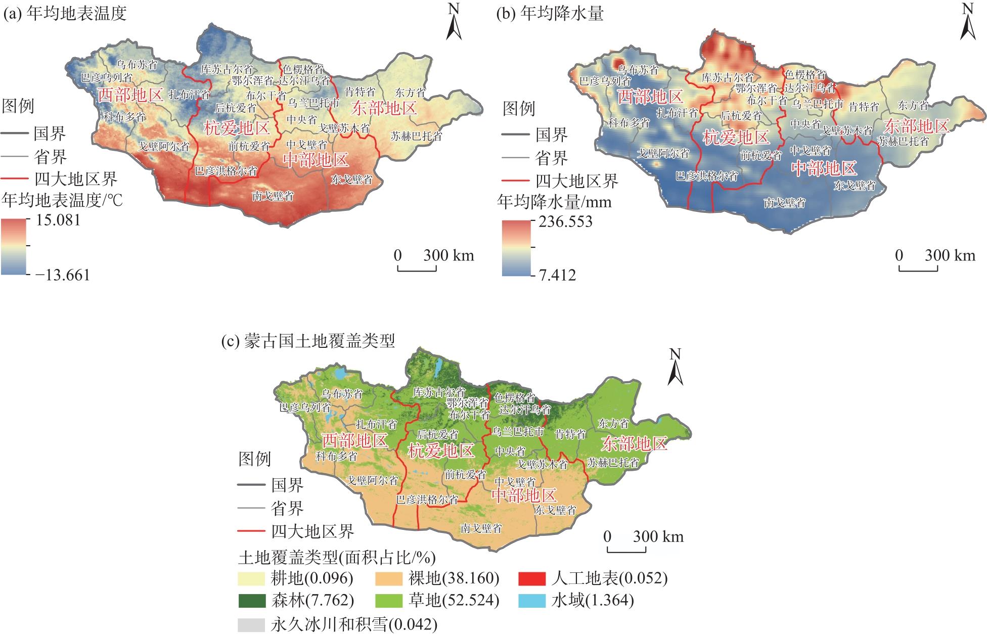
表1
数据描述"
| 数据类型 | 数据年份 | 空间分辨率 | 数据来源 |
|---|---|---|---|
| 蒙古国省域边界 | - | - | 蒙古国国家统计信息服务网( |
| 净初级生产力(NPP) | 2000—2020 | 500 m | 国家地球系统科学数据中心( |
| NO2排放量 | 2000—2020 | 0.008° | 美国国家航空航天局(NASA)( |
| 世界网格化牲畜数据集 | 2015 | 1 km | 联合国粮食及农业组织( |
| 风速 | 2000—2020 | 1 km | 谷歌地球引擎( |
| 数字高程模型(DEM) | 2020 | 30 m | 国家冰川冻土沙漠科学中心( |
| 年均地表温度 | 2003—2019 | 1 km | 青藏高原数据中心( |
| 实际蒸散发 | 2000—2020 | 1 km | 青藏高原数据中心( |
| 年均降水量 | 2000—2020 | 1 km | 欧洲气象卫星局( |
| 土壤水分 | 2000—2020 | 1 km | 谷歌地球引擎( |
| 人类足迹指数 | 2000—2020 | 1 km | 科学数据银行( |
| 夜间灯光 | 2000—2020 | 500 m | 国家地球系统科学数据中心( |
| 土地利用/覆盖 | 2000—2020 | 30 m | 地球大数据科学与工程数据中心( |
| 人口密度 | 2000—2020 | 1 km | 美国国家实验室( |
| 下行短波辐射 | 2000—2020 | 1 km | 欧洲气象中心( |
表2
交互作用类型"
| 判断标准 | 交互作用类型 |
|---|---|
| 非线性减弱 | |
| 双因子增强 | |
| 独立 | |
| 非线性增强 | |
| 单因子非线性减弱 |
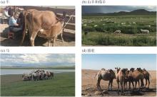
图2
蒙古国主要饲养牲畜"

图3
2000—2020年蒙古国NPP显著性检验"
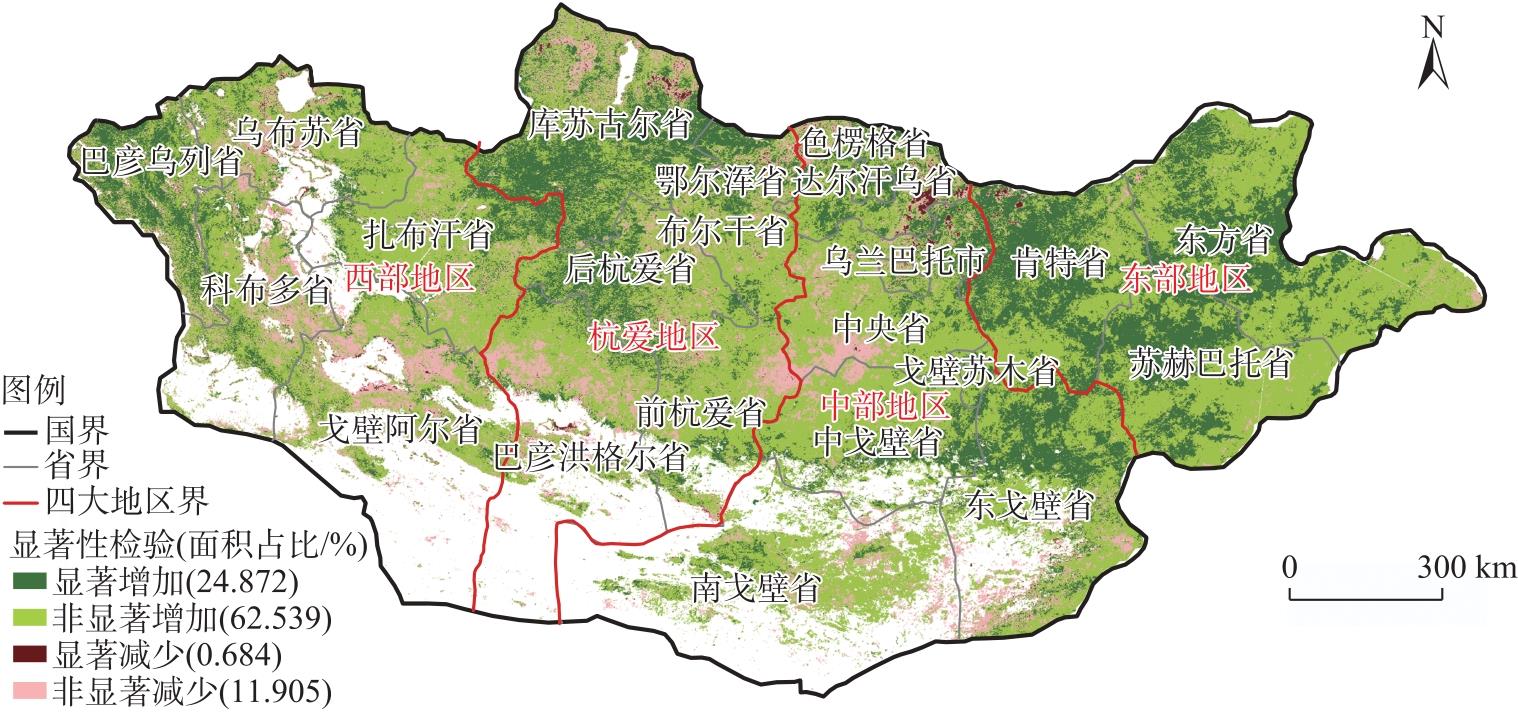

图4
2020年蒙古国放牧密度的空间分布格局及放牧密度模拟值精度评估 注:TLU为热带牲畜单位,1 TLU=250 kg;R2为判定系数;MAE为平均绝对误差;RMSE为均方根误差。"
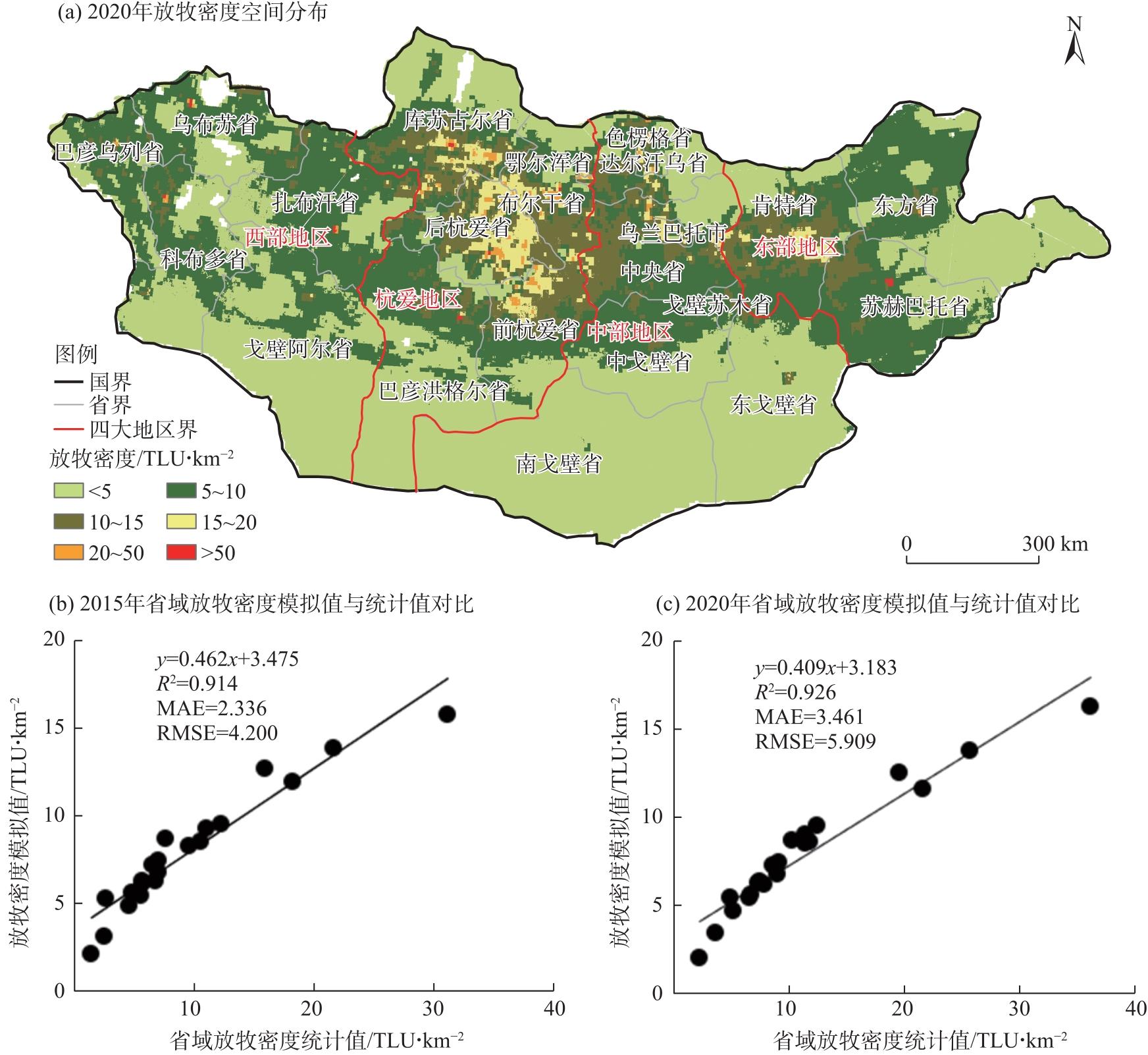
图5
单因子探测器和交互探测器结果 注:Rad为下行短波辐射;Pre为年均降水量;Sur为年均地表温度;Ele为海拔;Soi为土壤水分;Win为风速;NO2为NO2排放量;Liv为放牧密度;Hfi为人类足迹指数;q值为驱动因素解释力。下同。"

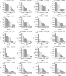
图6
蒙古国四大地区省域尺度NPP变化的单因子检测结果"
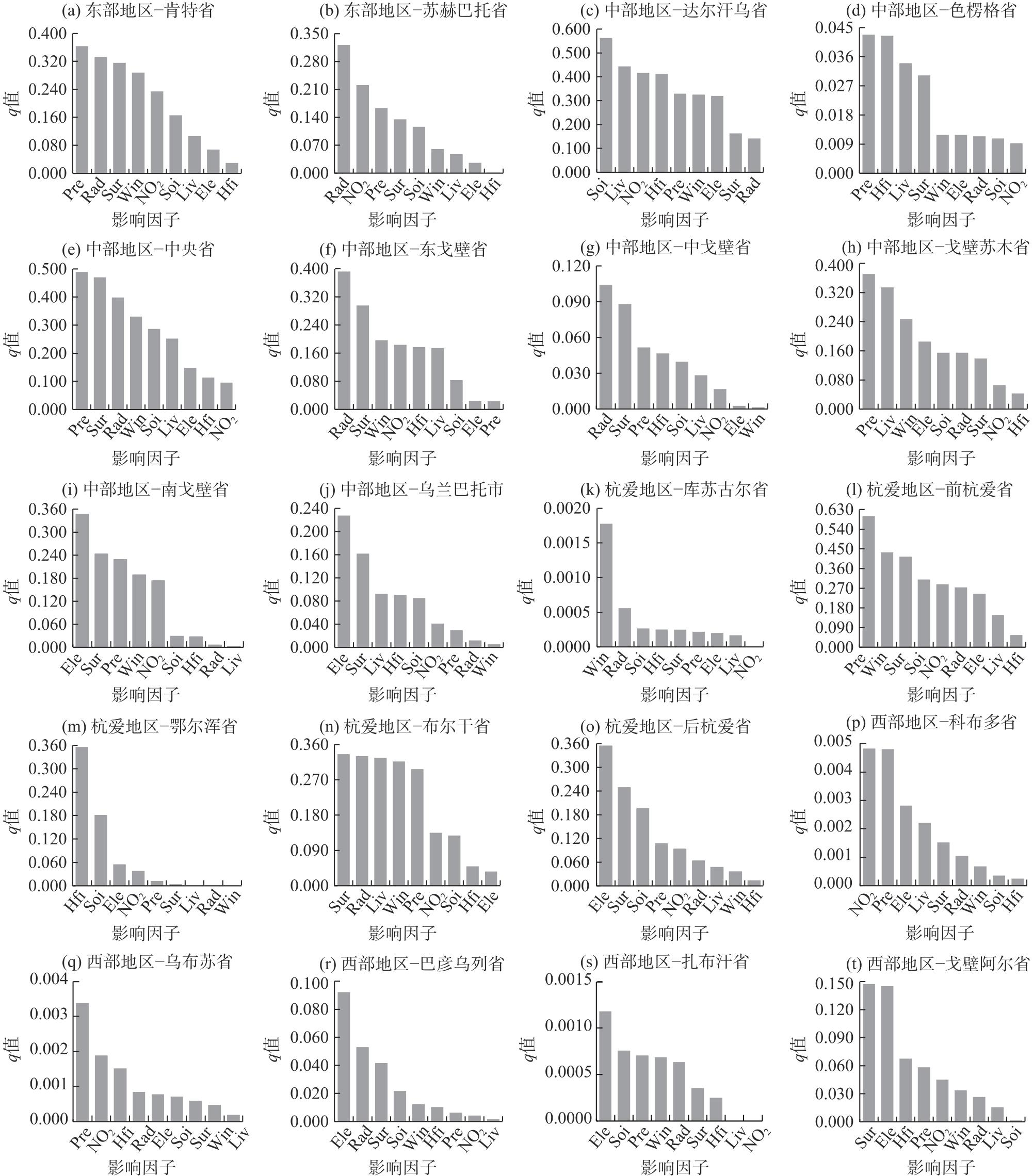

图7
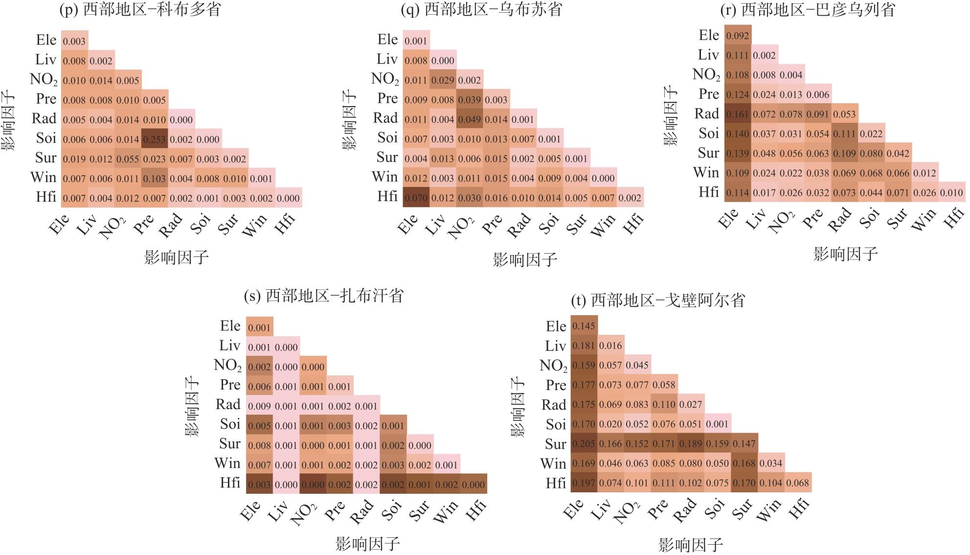
蒙古国省域尺度交互探测器结果"
| [1] | Halik G, Putra V S, Wiyono R U A. Assessment of climate change impact on drought disaster in Sampean Baru watershed, east Java, Indonesia based on IPCC-AR5[J]. Natural Hazards, 2022, 112: 1705-1726. |
| [2] | Liu Y Y, Wang Q, Zhang Z Y, et al. Grassland dynamics in responses to climate variation and human activities in China from 2000 to 2013[J]. Science of the Total Environment, 2019, 690: 27-39. |
| [3] |
Fan F, Liang C Z, Tang Y K, et al. Effects and relationships of grazing intensity on multiple ecosystem services in the Inner Mongolian steppe[J]. Science of the Total Environment, 2019, 675: 642-650.
doi: 10.1016/j.scitotenv.2019.04.279 |
| [4] | 爽武, 冯险峰, 孔玲玲, 等. 气候变化及人为干扰对西藏地区草地退化的影响研究[J]. 地理研究, 2021, 40(5): 1265-1279. |
| [Shuang Wu, Feng Xianfeng, Kong Lingling, et al. Effects of climate variation and human activities on grassland degradation in Tibet[J]. Geographical Research, 2021, 40(5): 1265-1279.] | |
| [5] | United Nations Convention to Combat Desertification (Secretariat). United Nations convention to combat desertification in those countries experiencing serious drought and/or desertification, particulary in Africa[M]. New York: Secretariat of the United Nations Convention to Combat Desertification, 1999: 1-56. |
| [6] | Chaves R B, Durigan G, Brancalion P H, et al. On the need of legal frameworks for assessing restoration projects success: New perspectives from São Paulo State (Brazil)[J]. Restoration Ecology, 2015, 23(6): 754-759. |
| [7] | Yang Y, Wang Z Q, Li J L, et al. Comparative assessment of grassland degradation dynamics in response to climate variation and human activities in China, Mongolia, Pakistan and Uzbekistan from 2000 to 2013[J]. Journal of Arid Environments, 2016, 135: 164-172. |
| [8] | Zhou W, Li J L, Mu S J, et al. Effects of ecological restoration-induced land-use change and improved management on grassland net primary productivity in the Shiyanghe River Basin, northwest China[J]. Grass and Forage Science, 2013, 69(4): 596-610. |
| [9] | Chang J F, Ciais P, Gasser T, et al. Climate warming from managed grasslands cancels the cooling effect of carbon sinks in sparsely grazed and natural grasslands[J]. Nature Communications, 2021, 12(1): 118, doi: 10.1038/s41467-020-20406-7. |
| [10] | Yan J J, Zhang G P, Deng X Y, et al. Does climate change or human activity lead to the degradation in the grassland ecosystem in a mountain-basin system in an arid region of China?[J]. Sustainability, 2019, 11(9): 2618, doi: 10.3390/su11092618. |
| [11] | Shao Y T, Wang J L. Vegetation phenology dataset in Mongolia (2001—2019)[J]. Journal of Global Change Data & Discovery, 2022, 6(2): 241-248. |
| [12] | Nanzad L, Zhang J H, Batdelger G, et al. Analyzing NPP response of different rangeland types to climatic parameters over Mongolia[J]. Agronomy, 2021, 11(4): 647, doi: 10.3390/agronomy11040647. |
| [13] | Lü G Y, Li X, Fang L, et al. Disentangling the influential factors driving NPP decrease in Shandong Province: An analysis from time series evaluation using MODIS and CASA model[J]. Remote Sensing, 2024, 16(11): 1966, doi: 10.3390/rs16111966. |
| [14] | 王川, 王丽莎, 张勇勇, 等. 2000—2020年祁连山植被净初级生产力时空变化及其驱动因素[J]. 生态学报, 2023, 43(23): 9710-9720. |
| [Wang Chuan, Wang Lisha, Zhang Yongyong, et al. Spatiotemporal change and driving factors of net primary productivity in Qilian Mountains from 2000 to 2020[J]. Acta Ecologica Sinica, 2023, 43(23): 9710-9720.] | |
| [15] | Meng X Y, Gao X, Li S, et al. Monitoring desertification in Mongolia based on Landsat images and Google Earth Engine from 1990 to 2020[J]. Ecological Indicators, 2021, 129(1): 107908, doi: 10.1016/j.ecolind.2021.107908. |
| [16] | Li M, Zhang X Z, Wu J S, et al. Declining human activity intensity on alpine grasslands of the Tibetan Plateau[J]. Journal of Environmental Management, 2021, 296: 113198, doi: 10.1016/j.jenvman.2021.113198. |
| [17] | 布仁高娃. 蒙古国荒漠化现状、成因及草原畜牧业前景研究[D]. 呼和浩特: 内蒙古大学, 2011. |
| [Buren Gova. Research on current status, causes and prospect of desertification in Mongolia[D]. Hohhot: Inner Mongolia University, 2011.] | |
| [18] | Wei Y J, Zhen L. The dynamics of livestock and its influencing factors on the Mongolian Plateau[J]. Environmental Development, 2020, 34: 100518, doi: 10.1016/j.envdev.2020.100518. |
| [19] | Lkhagvasuren Solongo (彩虹). 蒙古国肉类出口的影响因素分析[D]. 天津: 天津科技大学, 2020. |
| [Lkhagvasuren Solongo. Analysis of influential factors of Mongolia meat export[D]. Tianjin: Tianjin University of Science and Technology, 2020.] | |
| [20] | 孟小玉, 齐晓明, 佟宝全. 蒙古国矿产资源开发对经济发展的影响研究[J]. 干旱区资源与环境, 2021, 35(12): 100-105. |
| [Meng Xiaoyu, Qi Xiaoming, Tong Baoquan. Research on the influence of mineral resources exploitation on economic development in Mongolian[J]. Journal of Arid Land Resources and Environment, 2021, 35(12): 100-105.] | |
| [21] |
吕振涛, 李生宇, 彭中敏, 等. 蒙古国植被对干旱响应的敏感性研究[J]. 地理研究, 2021, 40(11): 3016-3028.
doi: 10.11821/dlyj020210105 |
| [Lü Zhentao, Li Shengyu, Peng Zhongmin, et al. Sensitivity of vegetation responses to drought in Mongolia[J]. Geographical Research, 2021, 40(11): 3016-3028.] | |
| [22] | 李一凡, 王卷乐, 祝俊祥. 基于地理分区的蒙古国景观格局分析[J]. 干旱区地理, 2016, 39(4): 817-827. |
| [Li Yifan, Wang Juanle, Zhu Junxiang. Landscape pattern analysis of Mongolia based on the geographical partitions[J]. Arid Land Geography, 2016, 39(4): 817-827.] | |
| [23] | Gang C C, Zhou W, Chen Y Z, et al. Quantitative assessment of the contributions of climate change and human activities on global grassland degradation[J]. Environmental Earth Sciences, 2014, 72(11): 4273-4282. |
| [24] | Ba W R, Qiu H T, Cao Y G. Spatiotemporal characteristics prediction and driving factors analysis of NPP in Shanxi Province covering the period 2001—2020[J]. Sustainability, 2023, 15(15): 12070, doi: 10.3390/su151512070. |
| [25] |
王劲峰, 徐成东. 地理探测器: 原理与展望[J]. 地理学报, 2017, 72(1): 116-134.
doi: 10.11821/dlxb201701010 |
|
[Wang Jinfeng, Xu Chengdong. Geodetector: Principle and prospective[J]. Acta Geographica Sinica, 2017, 72(1): 116-134.]
doi: 10.11821/dlxb201701010 |
|
| [26] |
夏婷婷, 薛璇, 王灏伟. 昆仑山北坡陆地水储量变化及其驱动因素分析[J]. 干旱区地理, 2024, 47(8): 1292-1303.
doi: 10.12118/j.issn.1000-6060.2024.094 |
|
[Xia Tingting, Xue Xuan, Wang Haowei. Changes in terrestrial water storage and its drivers on the north slope of Kunlun Mountains[J]. Arid Land Geography, 2024, 47(8): 1292-1303.]
doi: 10.12118/j.issn.1000-6060.2024.094 |
|
| [27] |
朱磊, 李燕楠, 徐佳慧. 中国冰雪旅游地空间分布格局及成因[J]. 干旱区地理, 2024, 47(8): 1399-1410.
doi: 10.12118/j.issn.1000-6060.2024.120 |
|
[Zhu Lei, Li Yannan, Xu Jiahui. Spatial distribution pattern and causes of ice and snow tourism in China[J]. Arid Land Geography, 2024, 47(8): 1399-1410.]
doi: 10.12118/j.issn.1000-6060.2024.120 |
|
| [28] | 齐小天, 张质明, 赵鑫, 等. 降雨径流污染风险等级识别与优化方法[J]. 环境科学, 2022, 43(3): 1500-1511. |
| [Qi Xiaotian, Zhang Zhiming, Zhao Xin, et al. Identification and optimization method of rainfall-runoff pollution risk level[J]. Environmental Science, 2022, 43(3): 1500-1511.] | |
| [29] | 邵嘉豪, 李晶, 闫星光, 等. 基于地理探测器的山西省2000—2020年NPP时空变化特征及驱动力分析[J]. 环境科学, 2023, 44(1): 312-322. |
| [Shao Jiahao, Li Jing, Yan Xingguang, et al. Analysis of spatiaotemporal variation characteristics and driving forces of NPP in Shanxi Province from 2000 to 2020 based on geodetector[J]. Environmental Science, 2023, 44(1): 312-322.] | |
| [30] | Bai L, Jiang L, Yang D Y, et al. Quantifying the spatial heterogeneity influences of natural and socioeconomic factors and their interactions on air pollution using the geographical detector method: A case study of the Yangtze River Economic Belt, China[J]. Journal of Cleaner Production, 2019, 232: 692-704. |
| [31] |
郭泽呈, 魏伟, 石培基, 等. 中国西北干旱区土地沙漠化敏感性时空格局[J]. 地理学报, 2020, 75(9): 1948-1965.
doi: 10.11821/dlxb202009010 |
|
[Guo Zecheng, Wei Wei, Shi Peiji, et al. Spatiotemporal changes of land desertification sensitivity in the arid region of northwest China[J]. Acta Geographica Sinica, 2020, 75(9): 1948-1965.]
doi: 10.11821/dlxb202009010 |
|
| [32] | Sun Y F, Guan Q Y, Wang Q Z, et al. Quantitative assessment of the impact of climatic factors on phenological changes in the Qilian Mountains, China[J]. Forest Ecology and Management, 2021, 499: 1-16. |
| [33] |
张皓哲, 薛亚永, 马圆圆. 新疆绿洲生态系统固碳潜力研究[J]. 干旱区研究, 2024, 41(6): 998-1009.
doi: 10.13866/j.azr.2024.06.09 |
|
[Zhang Haozhe, Xue Yayong, Ma Yuanyuan. Carbon sequestration potential of oasis ecosystems in Xinjiang[J]. Arid Zone Research, 2024, 41(6): 998-1009.]
doi: 10.13866/j.azr.2024.06.09 |
|
| [34] | Shao J H, Li J, Yan X G, et al. Analysis of spatiotemporal variation characteristics and driving forces of NPP in Shanxi Province from 2000 to 2020 based on geodetector[J]. Huan Jing Ke Xue, 2023, 44(1): 312-322. |
| [35] | Yang A L, Zhang H, Yang X J, et al. Quantitative analysis of the impact of climate change and human activities on vegetation NPP in the Qilian Mountain[J]. Human and Ecological Risk Assessment: An International Journal, 2023, 29(1): 202-221. |
| [36] | Chen J Q, John R, Zhang Y Q. Divergences of two coupled human and natural systems on the Mongolian Plateau[J]. Bioscience, 2015, 65(6): 559-570. |
| [37] | 叶中华. 中蒙两国交通运输领域合作成果丰硕[N]. 中国城市报, 2023-10-23(A07). |
| [Ye Zhonghua. China and Mongolia have fruitful cooperation in the field of transportation[N]. China City News, 2023-10-23(A07).] | |
| [38] | Yang Z S, Liu Y, Su H M, et al. Exploring complex place-based coevolution of ecosystem and human activities: A case study of Qilian Mountain area in China[J]. International Journal of Applied Earth Observation and Geoinformation, 2022, 115: 103091, doi: 10.1016/j.jag.2022.103091. |
| [39] | Otte J, Costales A, Dijkman J, et al. Livestock sector development for poverty reduction: An economic and policy perspective livestock many virtues[M]. Rome: Food and Agriculture Organization of the United Nations Rome, 2012: 1-7. |
| [40] |
李兰晖, 黄聪聪, 张镱锂, 等. 基于地理加权随机森林的青藏地区放牧强度时空格局模拟[J]. 地理科学, 2023, 43(3): 398-410.
doi: 10.13249/j.cnki.sgs.2023.03.003 |
| [Li Lanhui, Huang Congcong, Zhang Yili, et al. Mapping the multi-temporal grazing intensity on the Qinghai-Tibet Plateau using geographically weighted random forest[J]. Geographica Sinica, 2023, 43(3): 398-410.] | |
| [41] | 乌达巴拉, 何亭漪, 李秀男, 等. 蒙古国畜牧业发展现状[J]. 当代畜禽养殖业, 2022(1): 28-29, 37. |
| [Udabala, He Tingyi, Li Xiunan, et al. Current situation of livestock husbandry development in Mongolia[J]. Contemporary Livestock Farming, 2022(1): 28-29, 37.] | |
| [42] | 任小玢, 张东海, 俞鸿千, 等. 气候变化和人为活动在宁夏草地变化中的相对作用[J]. 生态学报, 2022, 42(19): 7989-8001. |
| [Ren Xiaobin, Zhang Donghai, Yu Hongqian, et al. Assessment of relative effects of climate change and human activities on grassland and dynamic in Ningxia[J]. Acta Ecologica Sinica, 2022, 42(19): 7989-8001.] | |
| [43] |
李霞, 张乐艺, 吴晨. 基于GEE和地理探测器的河南省不同流域植被变化及影响因素[J]. 应用生态学报, 2024, 35(7): 1887-1896.
doi: 10.13287/j.1001-9332.202407.021 |
|
[Li Xia, Zhang Leyi, Wu Chen. Vegetation changes and influencing factors in different watersheds of Henan Province based on GEE and geographic detectors[J]. Chinese Journal of Applied Ecology, 2024, 35(7): 1887-1896.]
doi: 10.13287/j.1001-9332.202407.021 |
|
| [44] | Yin C H, Chen X Q, Luo M, et al. Quantifying the contribution of driving factors on distribution and change of net primary productivity of vegetation in the Mongolian Plateau[J]. Remote Sensing, 2023, 15(8): 1986, doi: 10.1016/j.jclepro.2019.05.342. |
| [45] | 甘南, 宝音都仍, 闫晶晶. 蒙古国经济增长构成、动力及其影响因素[J]. 内蒙古农业大学学报(社会科学版), 2015, 17(1): 26-31. |
| [Gan Nan, Bao Yindureng, Yan Jingjing. Composition and dynamics of Mongolia’s economic growth and its influencing factors[J]. Journal of Inner Mongolia Agricultural University (Social Science Edtion), 2015, 17(1): 26-31.] | |
| [46] | Wang J L, Wei H S, Cheng K, et al. Spatio-temporal pattern of land degradation from 1990 to 2015 in Mongolia[J]. Environmental Development, 2020, 34: 100497, doi: 10.1016/j.envdev.2020.100497. |
| [47] |
吴雪晴, 张乐乐, 高黎明, 等. 青海湖流域NPP动态变化及驱动力[J]. 干旱区研究, 2023, 40(11): 1824-1832.
doi: 10.13866/j.azr.2023.11.12 |
|
[Wu Xueqing, Zhang Lele, Gao Liming, et al. Dynamic change and driving force of net primary productivity in Qinghai Lake Basin[J]. Arid Zone Research, 2023, 40(11): 1824-1832.]
doi: 10.13866/j.azr.2023.11.12 |
|
| [48] | 韩蕾, 齐晓明, 郝军. 基于资源环境承载力约束的蒙古国资源开发水平研究[J]. 干旱区资源与环境, 2021, 35(12): 93-99. |
| [Han Lei, Qi Xiaoming, Hao Jun. Natural resources development conditions and environmental carrying capacity in Mongolia[J]. Journal of Arid Land Resources and Environment, 2021, 35(12): 93-99.] | |
| [49] | 尹超华, 罗敏, 孟凡浩. 蒙古高原植被碳水利用效率时空变化特征及其影响因素[J]. 生态学杂志, 2022, 41(6): 1079-1089. |
|
[Yin Chaohua, Luo Min, Meng Fanhao. The spatiotemporal variation and influencing factors of vegetation carbon and water use efficiency in the Mongolian Plateau[J]. Chinese Journal of Ecology, 2022, 41(6): 1079-1089.]
doi: DOI: 10.13292/j.1000-4890.202205.008 |
|
| [50] | 朱思佳, 冯徽徽, 邹滨, 等. 2000—2019年洞庭湖流域植被NPP时空特征及驱动因素分析[J]. 自然资源遥感, 2022, 34(3): 196-206. |
| [Zhu Sijia, Feng Weiwei, Zou Bin, et al. Spatial-temporal characteristics of 2000—2019 vegetation NPP of the Dongting Lake Basin and their driving factors[J]. Remote Seneing for Natural Resources, 2022, 34(3): 196-206.] | |
| [51] | 张艳珍, 王钊齐, 杨悦, 等. 蒙古高原草地退化程度时空分布定量研究[J]. 草业科学, 2018, 35(2): 233-243. |
| [Zhang Yanzhen, Wang Zhaoqi, Yang Yue, et al. Research on the quantitative evaluation of grassland degradation and spatial and temporal distribution on the Mongolia Plateau[J]. Pratacultural Science, 2018, 35(2): 233-243.] | |
| [52] | 黄纤玉, 郝新, 陈静, 等. 基于博弈论的蒙古国经济社会-生态环境耦合协调度驱动因素及其特征研究[J]. 北京师范大学学报(自然科学版), 2024, 60(4): 499-508. |
| [Huang Qianyu, Hao Xin, Chen Jing, et al. Driving factors and characteristics of the coupling coordination degree of socio-economic development and eco-environment development in Mongolia based on game theory[J]. Journal of Beijing Normal University (Natural Science Edition), 2024, 60(4): 499-508.] | |
| [53] | Dedkov V P, Danzhalova E V, Tkachenko S N, et al. The influence of vegetation on reflected solar radiation in arid and extra-arid zone of Mongolian gobi[J]. Geography, Environment, Sustainability, 2020, 13(4): 72-80. |
| [1] | 刘京会, 袁旭山, 李艳敏, 李鑫旭. 基于CMIP6的伊犁河流域极端降水时空特征分析研究[J]. 干旱区地理, 2025, 48(8): 1329-1341. |
| [2] | 张毅明, 汤宇磊, 冯俊波. 基于随机森林模型的青藏高原冰川预测及分析[J]. 干旱区地理, 2025, 48(8): 1342-1352. |
| [3] | 张可心, 赵玉娟, 李美瑜. 1978—2023年陇东冰雹气候特征及其影响因素分析[J]. 干旱区地理, 2025, 48(8): 1374-1384. |
| [4] | 赵建文, 李金麟, 王圣杰. 祁连山土壤水分时空变化特征及主要驱动因素分析[J]. 干旱区地理, 2025, 48(8): 1480-1491. |
| [5] | 张昕晗, 赵文婷, 焦菊英, 马晓武, 杨波, 凌麒. 1960—2023年黄土高原极端降水事件时空演变特征[J]. 干旱区地理, 2025, 48(7): 1153-1166. |
| [6] | 程鹏, 彭海洋, 侯丁榕, 孙明东, 宋晓伟. 黄河流域农业灰水足迹强度空间格局及演进趋势[J]. 干旱区地理, 2025, 48(7): 1185-1197. |
| [7] | 郭念发, 王录仓. 兰州市主城区幼儿园入学可达性及影响因素分析[J]. 干旱区地理, 2025, 48(6): 1043-1054. |
| [8] | 魏建飞, 袁悠燃, 李强, 董佩佩, 刘玖榕. 黄河流域国土空间效率时空变化及障碍因子分析[J]. 干旱区地理, 2025, 48(6): 1055-1066. |
| [9] | 卢晗, 曾永年, 王盼成. 青藏高原东北部实际蒸散发时空变化特征及影响因素[J]. 干旱区地理, 2025, 48(5): 753-764. |
| [10] | 李梦冉, 徐小任, 王梁, 段健, 史舒琪, 任丹丹. 黄河流域农业碳排放时空变化特征及影响因素分析[J]. 干旱区地理, 2025, 48(5): 854-865. |
| [11] | 刘海军, 张海虹, 闫俊杰, 李想, 李高峰. 新疆农业碳排放效率时空异质性及其影响因素[J]. 干旱区地理, 2025, 48(5): 866-878. |
| [12] | 王立奇, 李国柱. 中国城市生态韧性时空特征及影响因素分析[J]. 干旱区地理, 2025, 48(5): 893-904. |
| [13] | 庞家朋, 李梦园. 中国旅游休闲街区空间差异及成因分析[J]. 干旱区地理, 2025, 48(5): 905-915. |
| [14] | 侯迎, 刘雯惠, 褚阳, 马小娟, 姚诗雨, 倪同欣. 贺兰山东麓绿洲多层次土壤水分亏缺及其影响因素的时空分析[J]. 干旱区地理, 2025, 48(4): 649-660. |
| [15] | 李维露, 张明斗. 黄河流域城市人口集聚与土地生态韧性的协同性研究[J]. 干旱区地理, 2025, 48(4): 728-738. |
|
||