干旱区地理 ›› 2025, Vol. 48 ›› Issue (10): 1878-1891.doi: 10.12118/j.issn.1000-6060.2025.052 cstr: 32274.14.ALG2025052
• 区域发展 • 上一篇
李占稳1( ), 吴文恒1,2(), 姚涵刚1, 朱昱泽1, 李钰萱1
收稿日期:2025-01-25
修回日期:2025-04-23
出版日期:2025-10-25
发布日期:2025-10-27
通讯作者:
吴文恒(1977-),男,教授,主要从事人口与资源环境研究. E-mail: wuwh@nwu.edu.cn作者简介:李占稳(2000-),男,硕士研究生,主要从事区域发展研究. E-mail: lizhanwen@stumail.nwu.edu.cn
基金资助:
LI Zhanwen1(), WU Wenheng1,2(), YAO Hangang1, ZHU Yuze1, LI Yuxuan1
Received:2025-01-25
Revised:2025-04-23
Published:2025-10-25
Online:2025-10-27
摘要:
探究黄河流域新型城镇化与农业现代化(“两化”)耦合协调关系,对落实黄河流域生态保护和高质量发展战略,推动城乡融合和区域协调发展具有重要意义。构建指标体系,运用熵值法、耦合协调度、地理探测器等方法,定量分析2010—2022年黄河流域67个地级市“两化”水平及其耦合协调的时空格局,探讨驱动机制。结果表明:(1) 研究期内黄河流域“两化”水平显著上升,均呈东高西低的空间分布格局。(2) “两化”耦合协调类型由濒临失调主导向勉强协调为主演化,初级和中级协调范围稳步扩大。(3) “两化”耦合协调水平空间集聚特征显著,在山东形成极热点核心及山西、甘肃、宁夏(甘宁)形成2个冷点聚集区。(4) 耦合协调发展空间分异格局是多因子协同作用、交互影响的结果。经济、市场、数字金融是核心驱动因子,农业科技、收入是次级驱动因子,交通与其他因子交互作用显著增强。研究结果有助于加强“两化”耦合理论认知,为流域推进“两化”战略、促进城乡融合发展提供政策参考。
李占稳, 吴文恒, 姚涵刚, 朱昱泽, 李钰萱. 黄河流域新型城镇化与农业现代化耦合协调的时空格局及驱动机制[J]. 干旱区地理, 2025, 48(10): 1878-1891.
LI Zhanwen, WU Wenheng, YAO Hangang, ZHU Yuze, LI Yuxuan. Spatio-temporal evolution and driving mechanism of coupling coordination between new urbanization and agricultural modernization in the Yellow River Basin[J]. Arid Land Geography, 2025, 48(10): 1878-1891.
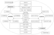
图1
新型城镇化与农业现代化耦合协调机理"

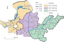
图2
黄河流域研究区位图 注:基于自然资源部标准地图服务网站审图号为GS(2019)1822号的标准地图制作,底图边界无修改。下同。"
表1
黄河流域“两化”耦合协调指标体系"
| 目标层 | 一级指标 | 二级指标 | 指标含义 | 指标属性 |
|---|---|---|---|---|
| 新型城镇化 | 人口城镇化 | 常住人口城镇化率/% | 城镇常住人口/年末常住人口 | + |
| 城镇人口密度/人·km-2 | 城镇常住人口/建成区面积 | + | ||
| 第二产业从业人员比例/% | 第二产业从业人员/总就业人员 | + | ||
| 第三产业从业人员比例/% | 第三产业从业人员/总就业人员 | + | ||
| 经济城镇化 | 第二、三产业产值占比/% | 第二、三产业产值/地区生产总值 | + | |
| 人均GDP/元 | 地区生产总值/年末总人口 | + | ||
| 城镇居民人均可支配收入/元 | 直接获取 | + | ||
| 城镇居民人均生活消费支出/元 | 直接获取 | + | ||
| 社会城镇化 | 人均社会消费品零售额/元 | 社会消费品零售总额/年末常住人口 | + | |
| 互联网接入用户/户 | 互联网接入用户 | + | ||
| 卫生技术人员数/人 | 卫生技术人员数 | + | ||
| 卫生机构床位数/张·10-4人 | 卫生机构床位数/年末常住人口 | + | ||
| 城镇登记失业率/% | 直接获取 | - | ||
| 空间城镇化 | 建成区面积/km2 | 建成区面积 | + | |
| 建成区经济密度/108元·km-2 | 第二、三产业产值/建成区面积 | + | ||
| 人均城市道路面积/m2 | 城区道路总面积/城区总人口 | + | ||
| 生态城镇化 | 人均公园绿地面积/m2 | 直接获取 | + | |
| 建成区绿化率/% | 直接获取 | + | ||
| 污水处理厂集中处理率/% | 达到排放标准的城市生活污水数量/城市生活污水排放总量 | + | ||
| 生活垃圾无害化处理率/% | 无害化处理的城镇垃圾数量/生活垃圾产生总量 | + | ||
| 农业现代化 | 农业投入水平 | 中间投入/104元 | 农林牧渔总产值-农林牧渔增加值 | - |
| 农村用电量/104 kW·h | 农村用电量 | + | ||
| 单位耕地面积农机总动力/kW·hm-2 | 农机总动力/耕地面积 | + | ||
| 粮食播种面积占比/% | 粮食播种面积/农作物播种面积 | + | ||
| 农业产出水平 | 土地生产率/104元·hm-2 | 农林牧渔总产值/耕地面积 | + | |
| 农业产出率/% | 农林牧渔增加值/农林牧渔总产值 | + | ||
| 农耕生产率/104元·kW-1 | 农林牧渔增加值/农机总动力 | + | ||
| 粮食作物单产/t·hm-2 | 粮食产量/粮食播种面积 | + | ||
| 农村社会发展水平 | 农村人均用电量/kW·h | 农村用电量/农村常住人口 | + | |
| 农村居民收入水平/元 | 农民人均可支配收入 | + | ||
| 农村居民消费水平/元 | 农村居民人均消费支出 | + | ||
| 农业经营产业化 | 农业社会化服务发展程度/% | 农林牧渔服务业产值/农林牧渔业总产值 | + | |
| 地理标志农产品数量/个 | 直接获取 | + | ||
| 国家农业科技园区数量/个 | 直接获取 | + | ||
| 农业产业化国家重点龙头企业数量/个 | 直接获取 | + | ||
| 农业可持续发展 | 人均耕地面积/hm2 | 耕地面积/农村常住人口 | + | |
| 中间消耗产出率/% | 中间消耗/农林牧渔增加值 | - | ||
| 单位耕地面积化肥施用量/t·hm-2 | 化肥施用量/耕地面积 | - | ||
| 植被覆盖率 | 归一化植被指数 | + |
表2
黄河流域“两化”耦合协调度等级划分标准"
| 耦合协调度 | 协调等级 | 耦合协调度 | 协调等级 |
|---|---|---|---|
| [0.0~0.2] | 严重失调 | (0.6~0.7] | 初级协调 |
| (0.2~0.3] | 中度失调 | (0.7~0.8] | 中级协调 |
| (0.3~0.4] | 轻度失调 | (0.8~0.9] | 良好协调 |
| (0.4~0.5] | 濒临失调 | (0.9~1.0] | 优质协调 |
| (0.5~0.6] | 勉强协调 |
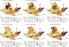
图3
黄河流域“两化”发展水平时空格局"

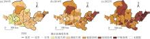
图4
黄河流域“两化”耦合协调度时空格局"
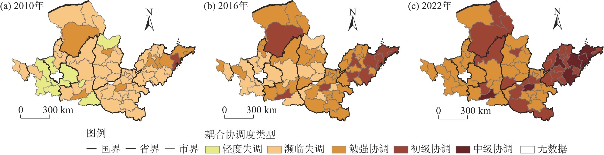
表3
黄河流域“两化”耦合协调度全局Moran's I"
| 年份 | 全局Moran's I | P值 |
|---|---|---|
| 2010 | 0.306*** | 0.000 |
| 2016 | 0.310*** | 0.000 |
| 2022 | 0.339*** | 0.000 |
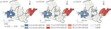
图5
黄河流域“两化”耦合协调度冷热点分布"

表4
耦合协调影响因素"
| 变量类型 | 驱动因素 | 符号 | 解释说明 |
|---|---|---|---|
| 被解释变量 | 耦合协调度 | D | 耦合协调度模型计算结果 |
| 经济 | eco | 第二、三产业增加值 | |
| 市场 | mar | 社会消费品零售总额 | |
| 数字金融 | dfin | 数字普惠金融指数 | |
| 收入 | inco | 城镇居民可支配收入/农村居民可支配收入 | |
| 人口 | pop | 第二、三产业从业人员/从业人员总数 | |
| 解释变量 | 农业科技 | atech | 农业机械总动力 |
| 交通 | tra | 公路里程/行政区面积 | |
| 开放 | open | 进出口总额/GDP | |
| 政府 | gov | 财政支出/GDP | |
| 创新 | inno | 科学技术支出/财政支出 |
表5
黄河流域“两化”耦合协调度的驱动因子探测结果"
| 序号 | 2010年 | 2016年 | 2022年 | ||||||||
|---|---|---|---|---|---|---|---|---|---|---|---|
| 因子排序 | q值 | P值 | 因子排序 | q值 | P值 | 因子排序 | q值 | P值 | |||
| 1 | eco | 0.761*** | 0.000 | eco | 0.807*** | 0.000 | eco | 0.831*** | 0.000 | ||
| 2 | mar | 0.751*** | 0.000 | mar | 0.795*** | 0.000 | mar | 0.818*** | 0.000 | ||
| 3 | dfin | 0.664*** | 0.000 | inno | 0.650*** | 0.000 | dfin | 0.728*** | 0.000 | ||
| 4 | inno | 0.624*** | 0.000 | open | 0.612*** | 0.000 | open | 0.644*** | 0.000 | ||
| 5 | gov | 0.555*** | 0.000 | dfin | 0.588*** | 0.000 | gov | 0.637*** | 0.000 | ||
| 6 | open | 0.531** | 0.019 | gov | 0.574*** | 0.005 | tra | 0.530*** | 0.004 | ||
| 7 | inco | 0.515*** | 0.000 | tra | 0.535*** | 0.002 | atech | 0.503** | 0.025 | ||
| 8 | pop | 0.510*** | 0.002 | atech | 0.484** | 0.016 | inno | 0.388** | 0.022 | ||
| 9 | atech | 0.394* | 0.045 | inco | 0.409** | 0.012 | pop | 0.331* | 0.069 | ||
| 10 | tra | 0.302* | 0.087 | pop | 0.239* | 0.056 | inco | 0.202* | 0.083 |

图6
黄河流域“两化”耦合协调度影响因子解释力和弦图 注:eco、mar、dfin等含义见表4。下同。"
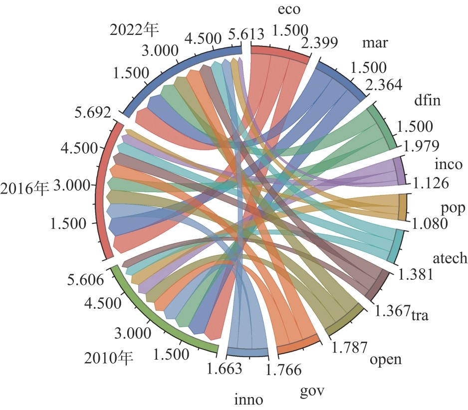
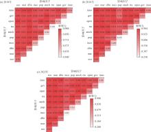
图7
黄河流域“两化”耦合协调度驱动因素交互探测结果"

| [1] |
陈明星, 叶超, 陆大道, 等. 中国特色新型城镇化理论内涵的认知与建构[J]. 地理学报, 2019, 74(4): 633-647.
doi: 10.11821/dlxb201904002 |
|
[Chen Mingxing, Ye Cao, Lu Dadao, et al. Cognition and construction of the theoretical connotation for new-type urbanization with Chinese characteristics[J]. Acta Geographica Sinica, 2019, 74(4): 633-647.]
doi: 10.11821/dlxb201904002 |
|
| [2] | 陈明星, 陆大道, 张华. 中国城市化水平的综合测度及其动力因子分析[J]. 地理学报, 2009, 64(4): 387-398. |
|
[Chen Mingxing, Lu Dadao, Zhang Hua. Comprehensive evaluation and the driving factors of China's urbanization[J]. Acta Geographica Sinica, 2009, 64(4): 387-398.]
doi: 10.11821/xb200904001 |
|
| [3] | 张红宇, 张海阳, 李伟毅, 等. 中国特色农业现代化: 目标定位与改革创新[J]. 中国农村经济, 2015(1): 4-13. |
| [Zhang Hongyu, Zhang Haiyang, Li Weiyi, et al. Agricultural modernization with Chinese characteristics: Target orientation and reform and innovation[J]. Chinese Rural Economy, 2015(1): 4-13.] | |
| [4] |
安晓宁, 辛岭. 中国农业现代化发展的时空特征与区域非均衡性[J]. 资源科学, 2020, 42(9): 1801-1815.
doi: 10.18402/resci.2020.09.14 |
|
[An Xiaoning, Xin Ling. The spatiotemporal characteristics and regional non-equilibrium of agricultural modernization development in China[J]. Resources Science, 2020, 42(9): 1801-1815.]
doi: 10.18402/resci.2020.09.14 |
|
| [5] |
蒋正云, 胡艳. 中部地区新型城镇化与农业现代化耦合协调机制及优化路径[J]. 自然资源学报, 2021, 36(3): 702-721.
doi: 10.31497/zrzyxb.20210313 |
| [Jiang Zhengyun, Hu Yan. Coupling and coordination between new urbanization and agricultural modernization in Central China[J]. Journal of Nature Resources, 2021, 36(3): 702-721.] | |
| [6] | 胡卫华. 美国城镇化与农业现代化协调发展经验借鉴[J]. 世界农业, 2015(2): 139-142. |
| [Hu Weihua. The experience reference of the coordinated development of urbanization and agricultural modernization in the United States[J]. World Agriculture, 2015(2): 139-142.] | |
| [7] | 刘玉. 农业现代化与城镇化协调发展研究[J]. 城市发展研究, 2007(6): 37-40. |
| [Liu Yu. The relations between agricultural modernization and urbanization[J]. Urban Development Studies, 2007(6): 37-40.] | |
| [8] | 汪晓文, 杜欣. 中国城镇化与农业现代化协调发展的测度[J]. 统计与决策, 2015(8): 121-124. |
| [Wang Xiaowen, Du Xin. Measurement of coordinated development of urbanization and agricultural modernization in China[J]. Statistics & Decision, 2015(8): 121-124.] | |
| [9] | 陈涛, 杨佳怡, 陈池波. 新型城镇化与农业现代化耦合协调度评价[J]. 统计与决策, 2022, 38(12): 70-74. |
| [Chen Tao, Yang Jiayi, Chen Chibo. Evaluation of the coupling coordination degree of new urbanization and agricultural modernization[J]. Statistics & Decision, 2022, 38(12): 70-74.] | |
| [10] |
陈莉, 闵晓飞. 农地“三权分置”下新疆新型城镇化与农业现代化协同发展研究[J]. 干旱区地理, 2018, 41(6): 1367-1375.
doi: 10.12118/j.issn.1000-6060.2018.06.25 |
| [Chen Li, Min Xiaofei. Coordinated development of new urbanization and agricultural modernization in Xinjiang under policy of “Three rights separation” for agricultural land[J]. Arid Land Geography, 2018, 41(6): 1367-1375.] | |
| [11] | 刘欣, 姚增福. 赤峰市城镇化与农业现代化协调演变及模式选择研究[J]. 中国农业资源与区划, 2018, 39(2): 214-220. |
| [Liu Xin, Yao Zengfu. Research on coordination evolution and pattern selection of urbanization and agricultural modernization[J]. Chinese Journal of Agricultural Resources and Regional Planning, 2018, 39(2): 214-220.] | |
| [12] | 文枫, 李会杰, 周彦兵, 等. 河南省新型城镇化与农业现代化协调关系测度[J]. 中国农业资源与区划, 2020, 41(4): 143-149. |
| [Wen Feng, Li Huijie, Zhou Yanbing, et al. Evaluation on the coordination relationship of the new urbanization and agricultural modernization in Henan Province[J]. Chinese Journal of Agricultural Resources and Regional Planning, 2020, 41(4): 143-149.] | |
| [13] | 代碧波, 陈晓菲. 粮食主产区农业现代化与新型城镇化的耦合协调度测算[J]. 统计与决策, 2020, 36(9): 104-108. |
| [Dai Bibo, Chen Xiaofei. Measurement of the coupling coordination degree between agricultural modernization and new urbanization in major food-producing areas[J]. Statistics & Decision, 2020, 36(9): 104-108.] | |
| [14] |
江孝君, 杨青山, 刘鉴. 中国地级以上城市 “五化” 协调发展时空格局及影响因素[J]. 地理科学进展, 2017, 36(7): 806-819.
doi: 10.18306/dlkxjz.2017.07.003 |
|
[Jiang Xiaojun, Yang Qingshan, Liu Jian. Spatiotemporal patterns and influencing factors of the “Five Modernizations” coordinated development of prefecture level and above cities in China[J]. Progress in Geography, 2017, 36(7): 806-819.]
doi: 10.18306/dlkxjz.2017.07.003 |
|
| [15] |
白雪, 宋玉祥, 浩飞龙. 东北地区“五化”协调发展的格局演变及影响机制[J]. 地理研究, 2018, 37(1): 67-80.
doi: 10.11821/dlyj201801005 |
| [Bai Xue, Song Yuxiang, Hao Feilong. Pattern evolution and influencing mechanism of coordination development of "Five Modernizations" in northeast China[J]. Geographical Research, 2018, 37(1): 67-80.] | |
| [16] |
潘竟虎, 胡艳兴, 刘晓, 等. 中国地级及以上城市“四化”协调发展效率的时空分异测度[J]. 地理科学, 2016, 36(4): 512-520.
doi: 10.13249/j.cnki.sgs.2016.04.004 |
| [Pan Jinghu, Hu Yanxing, Liu Xiao, et al. Spatial-temporal pattern of the coordinated development efficiency of the ‘Four Modernizations' of prefecture level cities or above in China[J]. Scientia Geographica Sinica, 2016, 36(4): 512-520.] | |
| [17] | 曹俊杰, 刘丽娟. 新型城镇化与农业现代化协调发展问题及对策研究[J]. 经济纵横, 2014(10): 12-15. |
| [Cao Junjie, Liu Lijuan. Research on the problems and countermeasures of the coordinated development of new urbanization and agricultural modernization[J]. Economic Review, 2014(10): 12-15.] | |
| [18] | 谢天成, 施祖麟. 城镇化与农业现代化协调发展研究——以昆山市为例[J]. 农业现代化研究, 2015, 36(6): 921-926. |
| [Xie Tiancheng, Shi Zulin. Coordinated development between urbanization and agricultural modernization: A case study in Kunshan City[J]. Research of Agricultural Modernization, 2015, 36(6): 921-926.] | |
| [19] | 张开华, 郑甘甜. 传统农区新型城镇化与农业现代化耦合协调路径研究[J]. 华东师范大学学报(哲学社会科学版), 2017, 49(4): 123-129. |
| [Zhang Kaihua, Zheng Gantian. On the coupling coordination of new urbanization and agricultural modernization in traditional rural areas[J]. Journal of East China Normal University (Humanities and Social Science), 2017, 49(4): 123-129.] | |
| [20] | 柯福艳. 统筹城乡背景下城镇化与农业现代化互促共进长效机制研究[J]. 农村经济, 2011(5): 36-39. |
| [Ke Fuyan. Study on the long-term mechanism of urbanization and agricultural modernization promoting each other under the background of coordinating urban and rural areas[J]. Rural Economy, 2011(5): 36-39.] | |
| [21] | 辛冲冲, 陈治国, 唐洪松, 等. 新疆农业现代化与城镇化协调发展关系的实证研究[J]. 农业现代化研究, 2016, 37(3): 430-436. |
| [Xin Chongchong, Chen Zhiguo, Tang Hongsong, et al. Empirical study on the coordinated development relationship between Xinjiang agricultural modernization and urbanization[J]. Research of Agricultural Modernization, 2016, 37(3): 430-436.] | |
| [22] |
田俊, 李旭东, 陈璇, 等. 黔中城市群新型城镇化与农业现代化耦合协调对城乡收入差距的影响[J]. 地理科学进展, 2024, 43(7): 1355-1371.
doi: 10.18306/dlkxjz.2024.07.007 |
|
[Tian Jun, Li Xudong, Chen Xuan, et al. Impact of coupling and coordination of new urbanization and agricultural modernization on the urban-rural income gap in the central Guizhou urban agglomeration[J]. Progress in Geography, 2024, 43(7): 1355-1371.]
doi: 10.18306/dlkxjz.2024.07.007 |
|
| [23] | Chen M X, Liu W D, Lu D D. Challenges and the way forward in China's new-type urbanization[J]. Land Use Policy, 2016, 55: 334-339. |
| [24] | Long H L, Li Y R, Liu Y S, et al. Accelerated restructuring in rural China fueled by ‘increasing vs. decreasing balance' land-use policy for dealing with hollowed villages[J]. Land Use Policy, 2012, 29(1): 11-22. |
| [25] |
叶超, 于洁. 迈向城乡融合: 新型城镇化与乡村振兴结合研究的关键与趋势[J]. 地理科学, 2020, 40(4): 528-534.
doi: 10.13249/j.cnki.sgs.2020.04.004 |
|
[Ye Chao, Yu Jie. Towards rural-urban integration: Key issues and trends on linking new-type urbanization to rural revitalization[J]. Scientia Geographica Sinica, 2020, 40(4): 528-534.]
doi: 10.13249/j.cnki.sgs.2020.04.004 |
|
| [26] |
乔家君, 肖杰. 黄河中下游乡村振兴与新型城镇化耦合协调机制研究[J]. 地理科学进展, 2024, 43(3): 417-433.
doi: 10.18306/dlkxjz.2024.03.001 |
|
[Qiao Jiajun, Xiao Jie. Spatial pattern and driving mechanism of the coordinated development of rural revitalization and new urbanization in the middle and lower reaches of the Yellow River[J]. Progress in Geography, 2024, 43(3): 417-433.]
doi: 10.18306/dlkxjz.2024.03.001 |
|
| [27] |
徐维祥, 李露, 周建平, 等. 乡村振兴与新型城镇化耦合协调的动态演进及其驱动机制[J]. 自然资源学报, 2020, 35(9): 2044-2062.
doi: 10.31497/zrzyxb.20200902 |
| [Xu Weixiang, Li Lu, Zhou Jianping, et al. The dynamic evolution and its driving mechanism of coordination of rural rejuvenation and new urbanization[J]. Journal of Nature Resources, 2020, 35(9): 2044-2062.] | |
| [28] |
邵海琴, 吴卫, 王兆峰. 长江经济带旅游资源绿色利用效率与新型城镇化的时空耦合协调[J]. 经济地理, 2021, 41(8): 204-213.
doi: 10.15957/j.cnki.jjdl.2021.08.024 |
|
[Shao Haiqin, Wu Wei, Wang Zhaofeng. Temporal and spatial coupling coordination of green utilization efficiency of tourism resources and new urbanization in the Yangtze River Economic Belt[J]. Economic Geography, 2021, 41(8): 204-213.]
doi: 10.15957/j.cnki.jjdl.2021.08.024 |
|
| [29] |
杨奇峰, 张平宇, 李静, 等. 东北地区农业现代化发展水平测度与时空演变分析[J]. 地理科学, 2022, 42(9): 1588-1599.
doi: 10.13249/j.cnki.sgs.2022.09.008 |
|
[Yang Qifeng, Zhang Pingyu, Li Jing, et al. Development level and spatio-temporal evolution of agricultural modernization in northeast China[J]. Scientia Geographica Sinica, 2022, 42(9): 1588-1599.]
doi: 10.13249/j.cnki.sgs.2022.09.008 |
|
| [30] | 李梦洁, 张亭好, 侯敬, 等. 山东省农业现代化发展水平时空演变及障碍因子研究[J]. 中国农业资源与区划, 2023, 44(7): 238-247. |
| [Li Mengjie, Zhang Tinghao, Hou Jing, et al. Research on spatial-temporal evolution and obstacle factors of agricultural modernization development level in Shandong Province[J]. Chinese Journal of Agricultural Resources and Regional Planning, 2023, 44(7): 238-247.] | |
| [31] |
杨华, 芮旸, 李炬霖, 等. 陕西省农业现代化水平时空特征及障碍因素[J]. 资源科学, 2020, 42(1): 172-183.
doi: 10.18402/resci.2020.01.17 |
|
[Yang Hua, Rui Yang, Li Julin, et al. Spatiotemporal characteristics of agricultural modernization level and obstacles in Shaanxi Province[J]. Resources Science, 2020, 42(1): 172-183.]
doi: 10.18402/resci.2020.01.17 |
|
| [32] |
刘玉洁, 吕硕, 陈洁, 等. 青藏高原农业现代化时空分异及其驱动机制[J]. 地理学报, 2022, 77(1): 214-227.
doi: 10.11821/dlxb202201015 |
|
[Liu Yujie, Lü Shuo, Chen Jie, et al. Spatio-temporal differentiation of agricultural modernization and its driving mechanism on the Qinghai-Tibet Plateau[J]. Acta Geographica Sinica, 2022, 77(1): 214-227.]
doi: 10.11821/dlxb202201015 |
|
| [33] |
万赟, 吴文恒, 刘金凤, 等. 近30 a黄河流域中心城市空间扩展特征及启示[J]. 干旱区地理, 2024, 47(2): 281-292.
doi: 10.12118/j.issn.1000-6060.2023.048 |
|
[Wan Yun, Wu Wenheng, Liu Jinfeng, et al. Spatial expansion characteristics and their enlightenment in central cities in the Yellow River Basin in the last 30 years[J]. Arid Land Geography, 2024, 47(2): 281-292.]
doi: 10.12118/j.issn.1000-6060.2023.048 |
|
| [34] | 刘畅, 邓铭, 冉春红. 东北地区农业现代化与新型城镇化协调发展研究[J]. 中国人口·资源与环境, 2017, 27(6): 155-162. |
| [Liu Chang, Deng Ming, Ran Chunhong. Research on the coordinated development of agricultural modernization and new urbanization in northeast China[J]. China Population, Resources and Environment, 2017, 27(6): 155-162.] | |
| [35] | 黄晶, 薛东前, 马蓓蓓, 等. 黄土高原乡村地域人—地—业协调发展时空格局与驱动机制[J]. 人文地理, 2021, 36(3): 117-128. |
| [Huang Jing, Xue Dongqian, Ma Beibei, et al. Spatial and temporal evolution pattern and driving mechanism of coordinated level of human-land-industry system in rural areas of the Loess Plateau[J]. Human Geography, 2021, 36(3): 117-128.] | |
| [36] |
王淑佳, 孔伟, 任亮, 等. 国内耦合协调度模型的误区及修正[J]. 自然资源学报, 2021, 36(3): 793-810.
doi: 10.31497/zrzyxb.20210319 |
| [Wang Shujia, Kong Wei, Ren Liang, et al. Research on misuses and modification of coupling coordination degree model in China[J]. Journal of Nature Resources, 2021, 36(3): 793-810.] | |
| [37] |
刘海猛, 胡森林, 方恺, 等. “一带一路”沿线国家政治-经济-社会风险综合评估及防控[J]. 地理研究, 2019, 38(12): 2966-2984.
doi: 10.11821/dlyj020181321 |
| [Liu Haimeng, Hu Senlin, Fang Kai, et al. A comprehensive assessment of political, economic and social risks and their prevention for the countries along the Belt and Road[J]. Geographical Research, 2019, 38(12): 2966-2984.] | |
| [38] | 王维. 长江经济带城乡协调发展评价及其时空格局[J]. 经济地理, 2017, 37(8): 60-66. |
| [Wang Wei. The evaluation of coordinated development level between urban and rural and its spatial-temporal pattern in Yangtze River Economic Zone[J]. Economic Geography, 2017, 37(8): 60-66.] | |
| [39] |
李琛, 吴映梅, 高彬嫔, 等. 高原湖泊乡村聚落空间分异及驱动力探测——以环洱海地区为例[J]. 经济地理, 2022, 42(4): 220-229.
doi: 10.15957/j.cnki.jjdl.2022.04.024 |
|
[Li Chen, Wu Yingmei, Gao Binpin, et al. Spatial differentiation and driving factors of rural settlement in plateau lake: A case study of the area around the Erhai[J]. Economic Geography, 2022, 42(4): 220-229.]
doi: 10.15957/j.cnki.jjdl.2022.04.024 |
|
| [40] |
王劲峰, 徐成东. 地理探测器: 原理与展望[J]. 地理学报, 2017, 72(1): 116-134.
doi: 10.11821/dlxb201701010 |
|
[Wang Jinfeng, Xu Chengdong. Geodetector: Principle and prospective[J]. Acta Geographica Sinica, 2017, 72(1): 116-134.]
doi: 10.11821/dlxb201701010 |
| [1] | 徐建斌, 曹小曙. 宁夏小流域尺度水土资源耦合特征及影响因素[J]. 干旱区地理, 2025, 48(9): 1531-1540. |
| [2] | 李亮亮, 夏咏, 王福红, 郭冰心, 赵兰兰. 新疆甜瓜生产格局及其贡献因素分析[J]. 干旱区地理, 2025, 48(9): 1567-1577. |
| [3] | 王晓菲, 邳华伟, 李思思. 青藏高原土壤风蚀潜力时空特征及驱动因素分析[J]. 干旱区地理, 2025, 48(9): 1589-1599. |
| [4] | 彭文英, 赵爽, 单子溢, 陈泽宇. 黄河流域新质生产力生态化水平测度与障碍因子[J]. 干旱区地理, 2025, 48(9): 1648-1659. |
| [5] | 田小波. 黄河流域城市旅游业高质量发展水平测度与空间格局特征[J]. 干旱区地理, 2025, 48(9): 1660-1671. |
| [6] | 李慧, 姚西龙. 水足迹视角下黄河流域可再生能源制氢节水潜力研究[J]. 干旱区地理, 2025, 48(8): 1353-1362. |
| [7] | 仲嘉维, 郑军, 张明月. 农业社会化服务如何影响粮食生态效率——以黄河流域71个地级市为例[J]. 干旱区地理, 2025, 48(8): 1385-1395. |
| [8] | 许静, 杨斌. 甘肃省新型城镇化与生态安全耦合协同及其驱动因素非平稳性[J]. 干旱区地理, 2025, 48(8): 1432-1444. |
| [9] | 高帅, 张务伟. 中国新质生产力与新型城镇化的协同演化研究[J]. 干旱区地理, 2025, 48(8): 1445-1456. |
| [10] | 周涛, 王亚娟, 刘小鹏. 宁夏沿黄城市群新型城镇化与低碳发展的耦合交互研究[J]. 干旱区地理, 2025, 48(8): 1457-1468. |
| [11] | 赵建文, 李金麟, 王圣杰. 祁连山土壤水分时空变化特征及主要驱动因素分析[J]. 干旱区地理, 2025, 48(8): 1480-1491. |
| [12] | 程鹏, 彭海洋, 侯丁榕, 孙明东, 宋晓伟. 黄河流域农业灰水足迹强度空间格局及演进趋势[J]. 干旱区地理, 2025, 48(7): 1185-1197. |
| [13] | 徐铭璟, 段宝玲, 冯强, 吕萌. 生态系统服务及其权衡/协同关系多情景模拟——以黄河流域山西段为例[J]. 干旱区地理, 2025, 48(7): 1206-1219. |
| [14] | 张晓明, 宿星, 张军, 贾静. 基于PLUS-InVEST模型的甘肃通渭滑坡区生境质量时空变化及预测[J]. 干旱区地理, 2025, 48(7): 1220-1232. |
| [15] | 夏梓洋, 夏云帆, 王宁, 林伟, 马丽娜, 谭晓平, 张艳珍, 焦瑞. 基于POI的天山北坡城市群旅游要素空间格局及影响因素[J]. 干旱区地理, 2025, 48(7): 1243-1254. |
|
||